55:
1237:
43:
75:
761:
1084:
1101:
1076:
1055:
366:
737:
In the town, the population was spread out, with 32.9% under 18, 9.3% from 18 to 24, 22.9% from 25 to 44, 17.6% from 45 to 64, and 17.3% who were 65 years of age or older. The median age was 30 years. For every 100 females, there were 101.7 males. For every 100 females aged 18 and over, there were
733:
living together, 8.7% had a female householder with no husband present, and 24.6% were non-families. 21.4% of all households were made up of individuals, and 10.3% had someone living alone who was 65 years of age or older. The average household size was 2.80 and the average family size was 3.23.
54:
407:, the town has a total area of 0.62 square miles (1.6 km), all land. It is situated at an altitude of 7,125 feet (2,172 m) above sea level, in the Rabbit Valley in south-central Utah. The
391:, offered a thousand-volume library to any Utah town that would rename itself after him. The town of Grayson also wanted the library prize, so in a compromise in 1916, Grayson took the name of
741:
The median income for a household in the town was $ 32,750, and the median income for a family was $ 34,500. Males had a median income of $ 29,750 versus $ 20,750 for females. The
706:
was 757.9 people per square mile (290.0/km). There were 143 housing units at an average density of 307.0 per square mile (117.5/km). The racial makeup of the town was 97.17%
411:
flows through the valley, which lies between 11,305-foot (3,446 m) Thousand Lake
Mountain to the north and 11,317-foot (3,449 m) Boulder Mountain to the south.
951:
1372:
1014:
1367:
1155:
380:, for A.K. Thurber, who in 1879 built the first house in the area. In 1897 the town moved to a new location due to sandy soil and poor water conditions.
897:
316:
1362:
88:
326:
1007:
936:
1148:
793:
774:
518:
872:
395:, Mr. Bicknell's wife's maiden name, as a tribute to her parents. The two towns split the library, each receiving 500 books.
1000:
987:
711:
42:
74:
1141:
1133:
847:
715:
404:
267:
487:
433:
420:
901:
664:
649:
634:
619:
604:
589:
574:
559:
354:
928:
412:
306:
142:
120:
1248:
481:
1357:
719:
505:
288:
416:
818:
475:
1334:
723:
408:
277:
1327:
1271:
707:
342:
1165:
729:
There were 126 households, out of which 38.1% had children under 18 living with them, 62.7% were
703:
493:
384:
346:
185:
147:
60:
963:
745:
for the town was $ 13,457. About 12.5% of families and 11.7% of the population were below the
932:
742:
522:
162:
1309:
1281:
1211:
463:
702:
of 2000, there were 353 people, 126 households, and 95 families residing in the town. The
1115:
1261:
1110:
1068:
1064:
499:
457:
392:
1351:
1256:
1120:
992:
1291:
1286:
1226:
1090:
898:"Geographic Identifiers: 2010 Demographic Profile Data (G001): Bicknell town, Utah"
746:
388:
813:
811:
1314:
1221:
1198:
1180:
1044:
1039:
766:
451:
439:
1301:
756:
445:
130:
103:
90:
1216:
1187:
1034:
258:
749:, including 13.6% of those under age 18 and 7.2% of those aged 65 or over.
365:
730:
180:
387:, a wealthy eastern author, historian, and Education Commissioner for
699:
364:
284:
263:
350:
135:
64:
1137:
996:
478:
wildlife habitat and fish hatchery (3.5 miles (5.6 km) SE)
1236:
1235:
868:
900:. U.S. Census Bureau, American Factfinder. Archived from
843:
508:(11,305 feet (3,446 m), 17 miles (27 km) NNE)
484:(11,317 feet (3,449 m), 37 miles (60 km) SE)
423:
Visitors Center is 17 miles (27 km) to the east.
502:
Tithing Office and
Granary (6 miles (10 km) SE)
1300:
1270:
1247:
1197:
988:
Wayne County
History @ Capitol Reef Country website
325:
315:
305:
295:
274:
257:
249:
241:
233:
228:
220:
212:
204:
196:
191:
179:
171:
161:
153:
141:
129:
119:
26:
1149:
1008:
892:
890:
8:
821:. United States Census Bureau. May 24, 2020
1156:
1142:
1134:
1015:
1001:
993:
726:of any race were 3.12% of the population.
532:
23:
16:Town in the state of Utah, United States
819:"Population and Housing Unit Estimates"
785:
314:
294:
256:
227:
219:
190:
152:
118:
83:
51:
39:
552:
1373:1879 establishments in Utah Territory
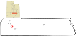
1240:Map of Utah highlighting Wayne County
838:
836:
525:, abbreviated "BSk" on climate maps.
462:228 miles (367 km) northeast of
438:110 miles (180 km) southwest of
432:120 miles (190 km) northeast of
324:
304:
273:
248:
240:
232:
211:
203:
195:
178:
170:
160:
140:
128:
79:Location of Utah in the United States
71:
7:
1368:Populated places established in 1879
1030:
718:, and 0.57% from two or more races.
216:0.00 sq mi (0.00 km)
208:0.57 sq mi (1.48 km)
200:0.57 sq mi (1.48 km)
1164:Municipalities and communities of
964:"Census of Population and Housing"
952:Climate Summary for Bicknell, Utah
542:
14:
1023:Places adjacent to Bicknell, Utah
456:212 miles (341 km) south of
450:169 miles (272 km) south of
1099:
1082:
1074:
1053:
775:List of cities and towns in Utah
759:
444:165 miles (266 km) west of
73:
53:
41:
873:United States Geological Survey
372:Bicknell was originally called
357:, the town population was 327.
869:"US Board on Geographic Names"
1:
1100:
1054:
796:. United States Census Bureau
519:Köppen Climate Classification
253:586.39/sq mi (226.32/km)
47:Aerial photograph of Bicknell
1083:
1075:
353:, United States. As of the
224:7,123 ft (2,171 m)
1363:Towns in Wayne County, Utah
848:United States Census Bureau
794:"2019 U.S. Gazetteer Files"
405:United States Census Bureau
242: • Estimate
21:Town in Utah, United States
1389:
923:Van Cott, John W. (1990).
488:Capitol Reef National Park
434:Bryce Canyon National Park
421:Capitol Reef National Park
1323:
1233:
1178:
1028:
691:
678:
663:
648:
633:
618:
603:
588:
573:
558:
551:
546:
541:
538:
496:(20 miles (32 km) E)
490:(17 miles (27 km) E)
84:
72:
52:
40:
33:
929:University of Utah Press
927:. Salt Lake City, Utah:
413:Fishlake National Forest
521:system, Bicknell has a
1241:
506:Thousand Lake Mountain
369:
104:38.34139°N 111.54556°W
1239:
844:"U.S. Census website"
692:U.S. Decennial Census
534:Historical population
419:is to the south. The
417:Dixie National Forest
415:is to the north, and
368:
276: • Summer (
1336:United States portal
904:on February 12, 2020
250: • Density
109:38.34139; -111.54556
535:
175:Albert King Thurber
100: /
1242:
1167:Wayne County, Utah
875:. October 25, 2007
704:population density
533:
494:Fruita Schoolhouse
385:Thomas W. Bicknell
370:
234: • Total
213: • Water
197: • Total
186:Thomas W. Bicknell
1345:
1344:
1131:
1130:
1126:
1125:
743:per capita income
696:
695:
523:semi-arid climate
517:According to the
403:According to the
336:
335:
205: • Land
63:and the state of
1380:
1337:
1330:
1238:
1190:
1183:
1173:
1168:
1158:
1151:
1144:
1135:
1103:
1102:
1086:
1085:
1078:
1077:
1057:
1056:
1031:
1017:
1010:
1003:
994:
976:
975:
973:
971:
960:
954:
949:
943:
942:
925:Utah Place Names
920:
914:
913:
911:
909:
894:
885:
884:
882:
880:
865:
859:
858:
856:
854:
840:
831:
830:
828:
826:
815:
806:
805:
803:
801:
790:
769:
764:
763:
762:
554:
549:
544:
536:
482:Boulder Mountain
476:Bicknell Bottoms
341:is a town along
281:
115:
114:
112:
111:
110:
105:
101:
98:
97:
96:
93:
77:
57:
45:
24:
1388:
1387:
1383:
1382:
1381:
1379:
1378:
1377:
1348:
1347:
1346:
1341:
1335:
1328:
1319:
1296:
1273:
1266:
1243:
1231:
1193:
1188:
1181:
1174:
1171:
1166:
1162:
1132:
1127:
1087:
1067:
1024:
1021:
984:
979:
969:
967:
962:
961:
957:
950:
946:
939:
922:
921:
917:
907:
905:
896:
895:
888:
878:
876:
867:
866:
862:
852:
850:
842:
841:
834:
824:
822:
817:
816:
809:
799:
797:
792:
791:
787:
783:
765:
760:
758:
755:
731:married couples
712:Native American
547:
531:
515:
472:
429:
401:
363:
301:
275:
108:
106:
102:
99:
94:
91:
89:
87:
86:
80:
68:
48:
36:
29:
22:
17:
12:
11:
5:
1386:
1384:
1376:
1375:
1370:
1365:
1360:
1350:
1349:
1343:
1342:
1340:
1339:
1332:
1324:
1321:
1320:
1318:
1317:
1312:
1306:
1304:
1298:
1297:
1295:
1294:
1289:
1284:
1278:
1276:
1272:Unincorporated
1268:
1267:
1265:
1264:
1259:
1253:
1251:
1245:
1244:
1234:
1232:
1230:
1229:
1224:
1219:
1214:
1209:
1203:
1201:
1195:
1194:
1179:
1176:
1175:
1163:
1161:
1160:
1153:
1146:
1138:
1129:
1128:
1124:
1123:
1118:
1113:
1107:
1106:
1104:
1097:
1094:
1093:
1088:
1073:
1071:
1061:
1060:
1058:
1051:
1048:
1047:
1042:
1037:
1029:
1026:
1025:
1022:
1020:
1019:
1012:
1005:
997:
991:
990:
983:
982:External links
980:
978:
977:
955:
944:
937:
931:. p. 31.
915:
886:
860:
832:
807:
784:
782:
779:
778:
777:
771:
770:
754:
751:
694:
693:
689:
688:
685:
683:
680:
676:
675:
672:
670:
667:
661:
660:
657:
655:
652:
646:
645:
642:
640:
637:
631:
630:
627:
625:
622:
616:
615:
612:
610:
607:
601:
600:
597:
595:
592:
586:
585:
582:
580:
577:
571:
570:
567:
565:
562:
556:
555:
550:
545:
540:
530:
527:
514:
511:
510:
509:
503:
497:
491:
485:
479:
471:
468:
467:
466:
460:
458:Salt Lake City
454:
448:
442:
436:
428:
425:
400:
397:
362:
359:
343:State Route 24
334:
333:
330:
323:
322:
319:
313:
312:
309:
303:
302:
299:
297:
293:
292:
282:
272:
271:
261:
255:
254:
251:
247:
246:
243:
239:
238:
235:
231:
230:
226:
225:
222:
218:
217:
214:
210:
209:
206:
202:
201:
198:
194:
193:
189:
188:
183:
177:
176:
173:
169:
168:
165:
159:
158:
155:
151:
150:
145:
139:
138:
133:
127:
126:
123:
117:
116:
82:
81:
78:
70:
69:
58:
50:
49:
46:
38:
37:
34:
31:
30:
28:Bicknell, Utah
27:
20:
15:
13:
10:
9:
6:
4:
3:
2:
1385:
1374:
1371:
1369:
1366:
1364:
1361:
1359:
1358:Towns in Utah
1356:
1355:
1353:
1338:
1333:
1331:
1326:
1325:
1322:
1316:
1313:
1311:
1308:
1307:
1305:
1303:
1299:
1293:
1290:
1288:
1285:
1283:
1280:
1279:
1277:
1275:
1269:
1263:
1260:
1258:
1255:
1254:
1252:
1250:
1246:
1228:
1225:
1223:
1220:
1218:
1215:
1213:
1210:
1208:
1205:
1204:
1202:
1200:
1196:
1192:
1191:
1184:
1177:
1172:United States
1169:
1159:
1154:
1152:
1147:
1145:
1140:
1139:
1136:
1122:
1119:
1117:
1114:
1112:
1109:
1108:
1105:
1098:
1096:
1095:
1092:
1089:
1081:
1072:
1070:
1066:
1063:
1062:
1059:
1052:
1050:
1049:
1046:
1043:
1041:
1038:
1036:
1033:
1032:
1027:
1018:
1013:
1011:
1006:
1004:
999:
998:
995:
989:
986:
985:
981:
965:
959:
956:
953:
948:
945:
940:
938:0-87480-345-4
934:
930:
926:
919:
916:
903:
899:
893:
891:
887:
874:
870:
864:
861:
849:
845:
839:
837:
833:
820:
814:
812:
808:
795:
789:
786:
780:
776:
773:
772:
768:
757:
752:
750:
748:
744:
739:
735:
732:
727:
725:
721:
717:
714:, 1.98% from
713:
709:
705:
701:
690:
686:
684:
681:
677:
673:
671:
668:
666:
662:
658:
656:
653:
651:
647:
643:
641:
638:
636:
632:
628:
626:
623:
621:
617:
613:
611:
608:
606:
602:
598:
596:
593:
591:
587:
583:
581:
578:
576:
572:
568:
566:
563:
561:
557:
537:
528:
526:
524:
520:
512:
507:
504:
501:
498:
495:
492:
489:
486:
483:
480:
477:
474:
473:
469:
465:
461:
459:
455:
453:
449:
447:
443:
441:
437:
435:
431:
430:
426:
424:
422:
418:
414:
410:
409:Fremont River
406:
398:
396:
394:
390:
386:
381:
379:
375:
367:
360:
358:
356:
352:
348:
344:
340:
331:
328:
320:
318:
310:
308:
298:
290:
286:
283:
279:
269:
265:
262:
260:
252:
244:
236:
223:
215:
207:
199:
187:
184:
182:
174:
166:
164:
156:
149:
146:
144:
137:
134:
132:
125:United States
124:
122:
113:
85:Coordinates:
76:
66:
62:
56:
44:
32:
25:
19:
1206:
1186:
1079:
968:. Retrieved
966:. Census.gov
958:
947:
924:
918:
906:. Retrieved
902:the original
877:. Retrieved
863:
851:. Retrieved
823:. Retrieved
798:. Retrieved
788:
747:poverty line
740:
738:97.5 males.
736:
728:
697:
529:Demographics
516:
402:
389:Rhode Island
382:
378:Thurber Town
377:
373:
371:
347:Wayne County
338:
337:
163:Incorporated
61:Wayne County
59:Location in
18:
1329:Utah portal
1302:Ghost towns
1274:communities
1182:County seat
908:February 1,
879:January 31,
853:January 31,
767:Utah portal
716:other races
679:2019 (est.)
355:2010 census
107: /
95:111°32′44″W
1352:Categories
1310:Eagle City
1282:Caineville
1212:Hanksville
781:References
698:As of the
470:Area sites
464:St. George
329:feature ID
229:Population
172:Founded by
92:38°20′29″N
1116:Escalante
800:August 7,
427:Distances
399:Geography
317:FIPS code
307:Area code
259:Time zone
221:Elevation
181:Named for
1262:Teasdale
1207:Bicknell
1111:Antimony
1080:Bicknell
1069:Kingston
1065:Junction
753:See also
720:Hispanic
710:, 0.28%
500:Teasdale
393:Blanding
383:In 1914
339:Bicknell
321:49-05490
296:ZIP code
1257:Fremont
1121:Boulder
970:June 4,
825:May 27,
513:Climate
374:Thurber
361:History
332:1438623
154:Settled
121:Country
1292:Grover
1287:Fruita
1227:Torrey
1091:Torrey
935:
724:Latino
700:census
614:−27.9%
539:Census
143:County
1315:Giles
1222:Lyman
1199:Towns
1045:Emery
1040:Lyman
708:White
674:−7.4%
644:10.5%
629:12.1%
599:−1.9%
452:Provo
440:Price
376:, or
300:84715
285:UTC-6
264:UTC-7
148:Wayne
131:State
1249:CDPs
972:2015
933:ISBN
910:2013
881:2008
855:2008
827:2020
802:2020
687:2.8%
665:2010
659:8.0%
650:2000
635:1990
620:1980
605:1970
590:1960
584:3.0%
575:1950
560:1940
548:Note
543:Pop.
446:Moab
351:Utah
327:GNIS
192:Area
167:1938
157:1879
136:Utah
65:Utah
35:Town
1217:Loa
1189:Loa
1035:Loa
722:or
682:336
669:327
654:353
639:327
624:296
609:264
594:366
579:373
564:362
345:in
311:435
289:MDT
278:DST
268:MST
245:336
237:327
1354::
1185::
1170:,
889:^
871:.
846:.
835:^
810:^
553:%±
349:,
1157:e
1150:t
1143:v
1016:e
1009:t
1002:v
974:.
941:.
912:.
883:.
857:.
829:.
804:.
569:—
291:)
287:(
280:)
270:)
266:(
67:.
Text is available under the Creative Commons Attribution-ShareAlike License. Additional terms may apply.