162:
138:
150:
19:
105:
The floods of 12 August 1948, in South-East
Scotland, Author: A. T. A. Learmonth, publ. in Scottish Geographical Journal, Volume 66, Issue 3 and 4 December 1950, pages 147 - 153
161:
137:
174:
213:
149:
72:
118:
92:
123:
39:
55:
35:
31:
207:
51:
47:
18:
189:
176:
67:
58:
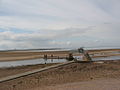
with its rather unusual bridge, whose ends are submerged at high tide.
43:
17:
93:"The Submerged Bridge over Biel Water in Belhaven Bay"
30:is a river running through the Biel Estate in
8:
143:New crossing at Biel Water, flood relief
133:
84:
34:. It runs for 4.5 kilometres from the
124:An Iron Age cist at North Belton Farm
7:
155:The Bridge at Biel Water, Belhaven
14:
119:RCAHMS record of Biel Mill Bridge
160:
148:
136:
73:List of places in East Lothian
1:
22:Biel Mill on the Biel Water
230:
167:The bridge at high tide
214:Rivers of East Lothian
23:
21:
190:55.97357°N 2.60507°W
186: /
195:55.97357; -2.60507
40:Whittinghame Water
32:Biel, East Lothian
24:
54:, and finally to
221:
201:
200:
198:
197:
196:
191:
187:
184:
183:
182:
179:
164:
152:
140:
106:
103:
97:
96:
89:
229:
228:
224:
223:
222:
220:
219:
218:
204:
203:
194:
192:
188:
185:
180:
177:
175:
173:
172:
168:
165:
156:
153:
144:
141:
132:
115:
110:
109:
104:
100:
91:
90:
86:
81:
64:
12:
11:
5:
227:
225:
217:
216:
206:
205:
170:
169:
166:
159:
157:
154:
147:
145:
142:
135:
131:
128:
127:
126:
121:
114:
113:External links
111:
108:
107:
98:
83:
82:
80:
77:
76:
75:
70:
63:
60:
13:
10:
9:
6:
4:
3:
2:
226:
215:
212:
211:
209:
202:
199:
163:
158:
151:
146:
139:
134:
130:Photo gallery
129:
125:
122:
120:
117:
116:
112:
102:
99:
94:
88:
85:
78:
74:
71:
69:
66:
65:
61:
59:
57:
53:
49:
45:
41:
37:
33:
29:
20:
16:
171:
101:
87:
56:Belhaven Bay
36:Luggate Burn
27:
25:
15:
193: /
178:55°58′25″N
79:References
52:West Barns
48:Biel House
28:Biel Water
181:2°36′18″W
208:Category
62:See also
38:and the
68:Stenton
44:Stenton
42:, via
26:The
210::
50:,
46:,
95:.
Text is available under the Creative Commons Attribution-ShareAlike License. Additional terms may apply.