58:
350:, Bisonvally had a population of 12,653 among which 6,332 are males and 6,321 are females. Bisonvalley village has an area of 32.62 km (12.59 sq mi) with 3,163 families residing in it. In Bisonvalley, 9.9% of the population was under 6 years of age. Bisonvalley had an average literacy of 93% higher than the national average of 74% and lower than state average of 94%.
40:
729:
127:
65:
446:
432:
363:
Bison valley is connected to a rural roads, 24 km (15 mi) form Munnar, about 133 km (83 mi) from Cochin, 30 km (19 mi) from
778:
532:
802:
450:
89:
797:
424:
57:
139:
771:
525:
396:
472:
267:
151:
764:
518:
589:
584:
171:
347:
247:
487:
319:
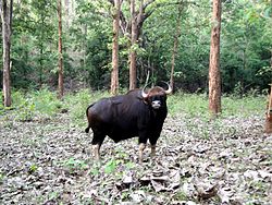
The name Bison valley is believed to tell the history of the place, Where the kings and officers of
255:
574:
320:
220:
466:
736:
579:
542:
296:
156:
39:
748:
304:
231:
510:
791:
368:
308:
685:
670:
665:
644:
599:
292:
604:
614:
594:
556:
400:
495:. Thiruvananthapuram: Directorate of Census Operations, Kerala. p. 58,59
104:
91:
693:
624:
380:
243:
238:
728:
703:
675:
639:
609:
331:
708:
634:
619:
404:
364:
324:
740:
698:
649:
629:
335:
303:. Bison valley is situated at around 914 metres (3000 ft) above
300:
280:
144:
449:. Registrar General & Census Commissioner, India. Archived from
744:
384:
327:
132:
44:
514:
447:"Census of India: Villages with population 5000 & above"
752:
684:
658:
567:
549:
276:
266:
254:
237:
227:
216:
211:
203:
195:
190:
182:
177:
167:
162:
150:
138:
120:
23:
433:Registrar General and Census Commissioner of India
425:"Table C-16 Population by Mother Tongue: Kerala"
772:
526:
8:
407:airports is 155 km from Bison valley.
779:
765:
533:
519:
511:
486:Kerala, Directorate of Census Operations.
379:The nearest major railway stations are at
20:
387:(approximately 140 kilometres by road).
416:
253:
236:
210:
189:
176:
161:
119:
84:
50:
36:
735:This article related to a location in
464:
367:, and 56 km (35 mi) from
275:
265:
226:
215:
202:
194:
186:32.62 km (12.59 sq mi)
181:
166:
149:
137:
7:
725:
723:
399:, which is 110 kilometers away. The
299:of the southwestern Indian state of
64:
14:
727:
489:District Census Handbook, Idukki
125:
63:
56:
38:
803:Idukki district geography stubs
580:Idukki-Painav,Idukki-Cheruthony
1:
751:. You can help Knowledge by
397:Cochin International Airport
798:Villages in Idukki district
819:
722:
207:390/km (1,000/sq mi)
85:
77:Location in Kerala, India
51:
37:
30:
18:Village in Kerala, India
590:Chelachuvadu-Keerithodu
395:The nearest airport is
471:: CS1 maint: others (
429:www.censusindia.gov.in
172:Panchayati Raj (India)
585:Thadiyampadu-Karimpan
228: • Minority
217: • Official
105:10.00000°N 77.06667°E
671:Karimkulam Chappathu
541:Cities and towns in
311:range of mountains.
268:Vehicle registration
204: • Density
101: /
575:Muttom, Thodupuzha
453:on 8 December 2008
321:east India company
196: • Total
183: • Total
110:10.00000; 77.06667
760:
759:
717:
716:
286:
285:
168: • Type
810:
781:
774:
767:
731:
724:
535:
528:
521:
512:
505:
504:
502:
500:
494:
483:
477:
476:
470:
462:
460:
458:
443:
437:
436:
421:
291:is a village in
131:
129:
128:
116:
115:
113:
112:
111:
106:
102:
99:
98:
97:
94:
67:
66:
60:
42:
21:
818:
817:
813:
812:
811:
809:
808:
807:
788:
787:
786:
785:
737:Idukki district
720:
718:
713:
680:
654:
563:
545:
543:Idukki district
539:
509:
508:
498:
496:
492:
485:
484:
480:
463:
456:
454:
445:
444:
440:
423:
422:
418:
413:
393:
377:
361:
356:
344:
317:
297:Idukki district
262:
126:
124:
109:
107:
103:
100:
95:
92:
90:
88:
87:
81:
80:
79:
78:
75:
74:
73:
72:
68:
47:
33:
26:
19:
12:
11:
5:
816:
814:
806:
805:
800:
790:
789:
784:
783:
776:
769:
761:
758:
757:
732:
715:
714:
712:
711:
706:
701:
696:
690:
688:
682:
681:
679:
678:
673:
668:
662:
660:
656:
655:
653:
652:
647:
642:
637:
632:
627:
622:
617:
612:
607:
602:
597:
592:
587:
582:
577:
571:
569:
565:
564:
562:
561:
559:
553:
551:
547:
546:
540:
538:
537:
530:
523:
515:
507:
506:
478:
438:
415:
414:
412:
409:
392:
389:
376:
373:
360:
357:
355:
354:Transportation
352:
343:
340:
316:
313:
305:mean sea level
284:
283:
278:
274:
273:
270:
264:
263:
260:
258:
252:
251:
241:
235:
234:
229:
225:
224:
218:
214:
213:
209:
208:
205:
201:
200:
197:
193:
192:
188:
187:
184:
180:
179:
175:
174:
169:
165:
164:
160:
159:
154:
148:
147:
142:
136:
135:
122:
118:
117:
83:
82:
76:
70:
69:
62:
61:
55:
54:
53:
52:
49:
48:
43:
35:
34:
31:
28:
27:
24:
17:
13:
10:
9:
6:
4:
3:
2:
815:
804:
801:
799:
796:
795:
793:
782:
777:
775:
770:
768:
763:
762:
756:
754:
750:
746:
742:
738:
733:
730:
726:
721:
710:
707:
705:
702:
700:
697:
695:
692:
691:
689:
687:
686:Hill stations
683:
677:
674:
672:
669:
667:
664:
663:
661:
657:
651:
648:
646:
643:
641:
638:
636:
633:
631:
628:
626:
623:
621:
618:
616:
613:
611:
608:
606:
603:
601:
598:
596:
593:
591:
588:
586:
583:
581:
578:
576:
573:
572:
570:
566:
560:
558:
555:
554:
552:
548:
544:
536:
531:
529:
524:
522:
517:
516:
513:
491:
490:
482:
479:
474:
468:
452:
448:
442:
439:
434:
430:
426:
420:
417:
410:
408:
406:
402:
398:
390:
388:
386:
382:
374:
372:
370:
369:Neriamangalam
366:
358:
353:
351:
349:
341:
339:
337:
333:
330:during their
329:
326:
322:
314:
312:
310:
309:Western Ghats
306:
302:
298:
295:Taluk in the
294:
290:
282:
279:
271:
269:
259:
257:
249:
245:
242:
240:
233:
230:
222:
219:
206:
198:
185:
173:
170:
158:
155:
153:
146:
143:
141:
134:
123:
114:
86:Coordinates:
59:
46:
41:
29:
22:
16:
753:expanding it
734:
719:
666:K. Chappathu
645:Vandiperiyar
600:Udumbanchola
497:. Retrieved
488:
481:
455:. Retrieved
451:the original
441:
428:
419:
394:
378:
362:
345:
342:Demographics
318:
293:Udumbanchola
289:Bison valley
288:
287:
277:Nearest city
15:
605:Nedumkandam
457:10 December
348:2011 Census
108: /
71:Bisonvalley
25:Bisonvalley
792:Categories
615:Kattappana
595:Kanjikuzhy
557:Thodupuzha
411:References
401:Coimbatore
191:Population
163:Government
694:Devikulam
625:Devikulam
381:Ernakulam
332:vacations
323:came for
315:Etymology
307:, in the
239:Time zone
223:, English
221:Malayalam
212:Languages
704:Peermade
676:Rajamala
659:Villages
640:Peermade
610:Rajakkad
467:cite web
244:UTC+5:30
152:District
96:77°4′0″E
93:10°0′0″N
709:Vagamon
635:Vagamon
620:Adimali
499:14 July
405:Madurai
391:Airport
375:Railway
365:Adimali
325:hunting
121:Country
32:village
741:Kerala
699:Munnar
650:Kumily
630:Munnar
550:Cities
346:As of
336:Munnar
301:Kerala
281:Munnar
261:685565
199:12,653
157:Idukki
145:Kerala
130:
747:is a
745:India
568:Towns
493:(PDF)
385:Aluva
328:bison
272:KL-69
232:Tamil
140:State
133:India
45:Bison
749:stub
501:2020
473:link
459:2008
403:and
383:and
359:Road
178:Area
334:in
256:PIN
248:IST
794::
743:,
739:,
469:}}
465:{{
431:.
427:.
371:.
338:.
780:e
773:t
766:v
755:.
534:e
527:t
520:v
503:.
475:)
461:.
435:.
250:)
246:(
Text is available under the Creative Commons Attribution-ShareAlike License. Additional terms may apply.