33:
145:
77:
The area around the river and Kelly Basin area is not in the South West World
Heritage area, but is on the edge, and has various conservation processes due to the history and ecology of the area.
230:
157:
259:
223:
264:
149:
216:
249:
254:
63:
44:
67:
52:
56:
48:
200:
243:
17:
32:
71:
172:
159:
144:
94:
196:
118:
31:
96:
Photograph - Bird River
Crossing, north Mt Lyell railway
204:
224:
117:Tasmania. Parks and Wildlife Service (1993),
8:
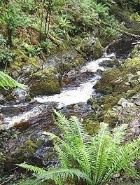
43:is a short river that drains in the area of
231:
217:
86:
66:had to cross the river before reaching
120:Kelly Basin-Bird River area site plan
7:
192:
190:
27:River in Western Tasmania, Australia
25:
143:
195:This article about a river in
1:
47:, at the southern end of the
203:. You can help Knowledge by
123:, Parks and Wildlife Service
281:
189:
99:, Libraries Tasmania, 1894
64:North Mount Lyell Railway
260:Tasmania geography stubs
173:42.35926°S 145.55327°E
37:
265:Australia river stubs
152:at Wikimedia Commons
35:
178:-42.35926; 145.55327
150:Bird River, Tasmania
18:Bird River, Tasmania
169: /
70:and the harbour in
250:Rivers of Tasmania
38:
255:Macquarie Harbour
212:
211:
148:Media related to
53:Macquarie Harbour
45:South Darwin Peak
16:(Redirected from
272:
233:
226:
219:
191:
184:
183:
181:
180:
179:
174:
170:
167:
166:
165:
162:
147:
132:
131:
130:
128:
114:
108:
107:
106:
104:
91:
57:Western Tasmania
49:West Coast Range
21:
280:
279:
275:
274:
273:
271:
270:
269:
240:
239:
238:
237:
187:
177:
175:
171:
168:
163:
160:
158:
156:
155:
141:
136:
135:
126:
124:
116:
115:
111:
102:
100:
93:
92:
88:
83:
28:
23:
22:
15:
12:
11:
5:
278:
276:
268:
267:
262:
257:
252:
242:
241:
236:
235:
228:
221:
213:
210:
209:
140:
139:External links
137:
134:
133:
109:
85:
84:
82:
79:
26:
24:
14:
13:
10:
9:
6:
4:
3:
2:
277:
266:
263:
261:
258:
256:
253:
251:
248:
247:
245:
234:
229:
227:
222:
220:
215:
214:
208:
206:
202:
198:
193:
188:
185:
182:
153:
151:
146:
138:
122:
121:
113:
110:
98:
97:
90:
87:
80:
78:
75:
73:
69:
65:
60:
59:, Australia.
58:
54:
50:
46:
42:
34:
30:
19:
205:expanding it
194:
186:
154:
142:
125:, retrieved
119:
112:
101:, retrieved
95:
89:
76:
61:
40:
39:
29:
176: /
164:145°33′12″E
72:Kelly Basin
244:Categories
161:42°21′33″S
81:References
41:Bird River
36:Bird River
68:Pillinger
197:Tasmania
103:26 April
127:11 July
51:, into
199:is a
201:stub
129:2015
105:2023
62:The
55:in
246::
74:.
232:e
225:t
218:v
207:.
20:)
Text is available under the Creative Commons Attribution-ShareAlike License. Additional terms may apply.