109:
254:
119:
168:
The area is bordered by the
Refstad neighborhood to the west and Brobekk to the east, and by Risløkka and Vollebekk to the south. The north side is bounded by
295:
42:
314:
319:
288:
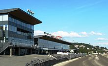
165:, a harness racing track (established in 1928), with its stadium building, stable building, and a large parking lot.
183:
Bjerkebanen mostly consists of residential buildings detached houses, townhouses, and small apartment buildings.
169:
281:
146:
162:
112:
17:
108:
265:
308:
158:
100:
16:
This article is about the Oslo neighborhood. For the harness racing track, see
57:
44:
87:
177:
118:
142:
127:
253:
154:
122:
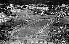
Bjerkebanen in Oslo in 1955. The stables are in the foreground, and
117:
107:
223:
261:
150:
191:(Økern Street) are the two largest streets in the area.
269:
96:
86:
78:
73:
28:
176:(Trondheim Street), separating the area from the
101:https://www.oslo.kommune.no/bydeler/bydel-bjerke/
289:
210:Det er vår egen by: Oslo ved 900 års jubileet
8:
296:
282:
25:
200:
95:
85:
72:
77:
7:
250:
248:
14:
212:. Oslo: Oslo kommune. p. 65.
252:
161:. The area is dominated by the
1:
268:. You can help Knowledge by
141:, is a neighborhood in the
336:
247:
130:Street) lies to the right.
15:
170:Norwegian National Road 4
38:
149:borough in northeastern
32:
315:Neighbourhoods of Oslo
264:location article is a
208:Heiberg, Hans (1950).
137:, often simply called
131:
115:
228:Store norske leksikon
187:(Refstad Street) and
121:
111:
320:Oslo geography stubs
58:59.9446°N 10.8068°E
54: /
132:
116:
79: • Total
277:
276:
224:"Bjerke Travbane"
163:Bjerke Race Track
157:. It lies in the
113:Bjerke Race Track
106:
105:
327:
298:
291:
284:
256:
249:
239:
238:
236:
234:
220:
214:
213:
205:
145:district of the
69:
68:
66:
65:
64:
63:59.9446; 10.8068
59:
55:
52:
51:
50:
47:
26:
335:
334:
330:
329:
328:
326:
325:
324:
305:
304:
303:
302:
245:
243:
242:
232:
230:
222:
221:
217:
207:
206:
202:
197:
174:Trondheimsveien
62:
60:
56:
53:
48:
45:
43:
41:
40:
34:
31:
24:
21:
18:Bjerke Travbane
12:
11:
5:
333:
331:
323:
322:
317:
307:
306:
301:
300:
293:
286:
278:
275:
274:
257:
241:
240:
215:
199:
198:
196:
193:
180:neighborhood.
104:
103:
98:
94:
93:
90:
84:
83:
80:
76:
75:
71:
70:
36:
35:
29:
22:
13:
10:
9:
6:
4:
3:
2:
332:
321:
318:
316:
313:
312:
310:
299:
294:
292:
287:
285:
280:
279:
273:
271:
267:
263:
258:
255:
251:
246:
229:
225:
219:
216:
211:
204:
201:
194:
192:
190:
186:
181:
179:
175:
171:
166:
164:
160:
159:Grorud Valley
156:
152:
148:
144:
140:
136:
129:
125:
120:
114:
110:
102:
99:
91:
89:
81:
67:
39:Coordinates:
37:
27:
19:
270:expanding it
259:
244:
231:. Retrieved
227:
218:
209:
203:
188:
185:Refstadveien
184:
182:
173:
167:
138:
134:
133:
123:
135:Bjerkebanen
61: /
30:Bjerkebanen
309:Categories
195:References
189:Økernveien
124:Økernveien
74:Population
49:10°48′24″E
46:59°56′41″N
88:Time zone
233:May 12,
97:Website
178:Årvoll
155:Norway
147:Bjerke
139:Bjerke
82:33,422
33:Bjerke
260:This
143:Økern
128:Økern
92:GMT+1
23:Place
266:stub
262:Oslo
235:2018
172:and
151:Oslo
311::
226:.
153:,
297:e
290:t
283:v
272:.
237:.
126:(
20:.
Text is available under the Creative Commons Attribution-ShareAlike License. Additional terms may apply.