298:
29:
437:
The largest floods on the Blšanka (monitored since 1905) were in 1956, when the water level rose to 280 cm (110 in). The most devastating flash floods were in 1872, when they killed over 100 people.
369:
There are 257 bodies of water in the basin area. The largest of them is the Blatno fishpond with an area of 30 ha (74 acres). There are no fishponds or reservoirs built directly on the Blšanka.
561:
447:
556:
541:
382:
414:
145:
317:, where it enters the Ohře River at the elevation of 189 m (620 ft). It is 50.8 km (31.6 mi) long. Its
406:
57:
274:
62:
513:
377:
There are no notable settlements on the river. The largest settlement on the Blšanka is the town of
306:
91:
297:
537:
429:
Trout fishing is allowed in a 22.66 km (14.08 mi) long section on the upper course.
310:
95:
418:
318:
314:
262:
50:
470:
550:
28:
402:
116:
491:
410:
160:
147:
514:"Blšanka. Malebná říčka mezi poli a chmelnicemi. Ale i živel, který zabíjel"
266:
245:
398:
394:
286:
34:
390:
386:
270:
237:
131:
378:
296:
258:
241:
313:
at the elevation of 680 m (2,230 ft) and flows to
381:. The river flows through the municipal territories of
321:
has an area of 482.7 km (186.4 sq mi).
471:"Základní charakteristiky toku Blšanka a jeho povodí"
305:The Blšanka originates in the southern part of the
233:
228:
214:
206:
194:
186:
176:
137:
125:
115:
101:
85:
77:
68:
56:
46:
41:
21:
473:(in Czech). T. G. Masaryk Water Research Institute
220:1.05 m/s (37 cu ft/s) near estuary
540:– Flood Warning and Forecasting Service of the
8:
324:The longest tributaries of the Blšanka are:
277:. It is 50.8 km (31.6 mi) long.
465:
463:
326:
459:
16:River in Ústí nad Labem, Czech Republic
18:
285:The river is named after the town of
198:482.7 km (186.4 sq mi)
7:
448:List of rivers of the Czech Republic
562:Rivers of the Ústí nad Labem Region
542:Czech Hydrometeorological Institute
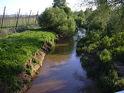
301:Confluence of the Blšanka and Ohře
14:
27:
307:Hradiště Military Training Area
92:Hradiště Military Training Area
139: • coordinates
1:
538:River flow at Stránky station
69:Physical characteristics
273:River. It flows through the
178: • elevation
103: • elevation
190:50.8 km (31.6 mi)
127: • location
87: • location
578:
512:Kinšt, Petr (2013-06-11).
216: • average
107:680 m (2,230 ft)
494:(in Czech). NajdiRevír.cz
224:
202:
111:
73:
26:
182:189 m (620 ft)
557:Tributaries of the Ohře
302:
492:"443 004 – Blšanka 1"
300:
275:Ústí nad Labem Region
161:50.31833°N 13.60944°E
516:(in Czech). Deník.cz
229:Basin features
157: /
303:
166:50.31833; 13.60944
362:
361:
251:
250:
569:
525:
524:
522:
521:
509:
503:
502:
500:
499:
488:
482:
481:
479:
478:
467:
352:Podvinecký potok
327:
311:Doupov Mountains
217:
172:
171:
169:
168:
167:
162:
158:
155:
154:
153:
150:
104:
96:Doupov Mountains
88:
31:
19:
577:
576:
572:
571:
570:
568:
567:
566:
547:
546:
534:
529:
528:
519:
517:
511:
510:
506:
497:
495:
490:
489:
485:
476:
474:
469:
468:
461:
456:
444:
435:
427:
375:
367:
365:Bodies of water
295:
283:
215:
179:
165:
163:
159:
156:
151:
148:
146:
144:
143:
140:
128:
102:
86:
37:
33:The Blšanka in
17:
12:
11:
5:
575:
573:
565:
564:
559:
549:
548:
545:
544:
533:
532:External links
530:
527:
526:
504:
483:
458:
457:
455:
452:
451:
450:
443:
440:
434:
431:
426:
423:
374:
371:
366:
363:
360:
359:
356:
353:
349:
348:
345:
342:
341:Mlýnecký potok
338:
337:
334:
331:
319:drainage basin
294:
293:Characteristic
291:
282:
279:
263:Czech Republic
249:
248:
235:
231:
230:
226:
225:
222:
221:
218:
212:
211:
208:
204:
203:
200:
199:
196:
192:
191:
188:
184:
183:
180:
177:
174:
173:
141:
138:
135:
134:
129:
126:
123:
122:
119:
113:
112:
109:
108:
105:
99:
98:
89:
83:
82:
79:
75:
74:
71:
70:
66:
65:
63:Ústí nad Labem
60:
54:
53:
51:Czech Republic
48:
44:
43:
39:
38:
32:
24:
23:
15:
13:
10:
9:
6:
4:
3:
2:
574:
563:
560:
558:
555:
554:
552:
543:
539:
536:
535:
531:
515:
508:
505:
493:
487:
484:
472:
466:
464:
460:
453:
449:
446:
445:
441:
439:
432:
430:
424:
422:
420:
416:
412:
408:
404:
400:
396:
392:
388:
384:
380:
372:
370:
364:
357:
354:
351:
350:
346:
343:
340:
339:
335:
332:
329:
328:
325:
322:
320:
316:
312:
308:
299:
292:
290:
288:
280:
278:
276:
272:
268:
264:
260:
256:
247:
243:
239:
236:
232:
227:
223:
219:
213:
209:
205:
201:
197:
193:
189:
185:
181:
175:
170:
142:
136:
133:
130:
124:
120:
118:
114:
110:
106:
100:
97:
93:
90:
84:
80:
76:
72:
67:
64:
61:
59:
55:
52:
49:
45:
40:
36:
30:
25:
20:
518:. Retrieved
507:
496:. Retrieved
486:
475:. Retrieved
436:
428:
376:
368:
323:
304:
284:
254:
252:
373:Settlements
333:Length (km)
234:Progression
164: /
551:Categories
520:2023-10-06
498:2023-10-06
477:2023-10-06
454:References
265:, a right
195:Basin size
152:13°36′34″E
35:Liběšovice
407:Měcholupy
393:, Kryry,
330:Tributary
281:Etymology
267:tributary
246:North Sea
207:Discharge
149:50°19′6″N
442:See also
419:Zálužice
415:Liběšice
403:Libořice
315:Zálužice
42:Location
411:Holedeč
391:Vroutek
387:Lubenec
309:in the
269:of the
261:in the
255:Blšanka
47:Country
22:Blšanka
433:Floods
399:Blšany
395:Očihov
358:right
287:Blšany
210:
187:Length
121:
81:
78:Source
58:Region
383:Valeč
379:Kryry
347:left
336:Side
259:river
257:is a
117:Mouth
417:and
355:17.9
344:18.1
271:Ohře
253:The
242:Elbe
238:Ohře
132:Ohře
425:Use
553::
462:^
421:.
413:,
409:,
405:,
401:,
397:,
389:,
385:,
289:.
244:→
240:→
94:,
523:.
501:.
480:.
Text is available under the Creative Commons Attribution-ShareAlike License. Additional terms may apply.