1184:
199:
206:
1226:
1198:
4804:
4463:
1719:
6241:
1212:
698:
43:
661:
road accesses Como Lake 11,750 feet (3,580 m), and provides the most common access to Blanca Peak. Most vehicles stop at an elevation of between 8,000 feet (2,400 m) and 10,000 feet (3,000 m) on this road. The Como Lake Road is a designated
Alamosa County Road and runs to the edge of
674:
on the North Face of Blanca Peak. Blanca Creek drains Blanca Basin under the south slopes of the peak, and Little Ute Creek descends from the
Winchell Lakes on the southeast side. However these are not used to access the peak due to private property.
564:. Below the steep North Face of Blanca Peak two live Glaciers once developed, until extinction sometime after 1903. North & South Blanca Glaciers were located at 37° 35N.,longitude 105° 28W. Blanca Peak is higher than any point in the
6315:
690:
to the southwest. Ellingwood Point is connected to Blanca by a short, high ridge, and is often climbed in conjunction with Blanca. Little Bear also has a high connecting ridge to Blanca, but it is a
670:
flows from the north side of Blanca Peak. A road, starting out as a two-wheel drive road, then becoming a four-wheel drive road (less challenging than the Como Lake Road), provides access to the
119:
5206:
1120:, the traditional Navajo homeland. It is associated with the color white, and is said to be covered in daylight and dawn and fastened to the ground with lightning. It is gendered male.
113:
107:
3772:
101:
657:
Blanca Peak heads up three major creeks. Holbrook Creek is on the west, flowing from a basin including Crater Lake, Blue Lakes, and Como Lake. An extremely challenging
5221:
4468:
642:
to the west. For example, it rises nearly 7,000 feet (2,100 m) over the edge of the San Luis Valley in only 6 miles (9.7 km). Blanca is also the third most
6280:
6275:
1707:
1675:
6270:
5261:
4792:
638:
Blanca Peak is notable not only for its absolute height, but also for its great local relief and dominant position at the end of the range, rising high above the
4429:
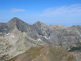
5176:
2136:
489:
155:
125:
1505:
3172:
1244:
702:
632:
5236:
4451:
2712:
6310:
5336:
3383:
5316:
3221:
1851:
1388:
3200:
1239:
379:
6305:
4188:
3695:
3122:
2156:
2101:
1997:
1740:
198:
1685:
5301:
5271:
4770:
2961:
2586:
1861:
1490:
1311:
1294:
6138:
5321:
5256:
3763:
2331:
2091:
6295:
6290:
6285:
5281:
2462:
2151:
1700:
1379:
1270:
1254:
604:
553:
513:
442:
253:
218:
137:
5417:
5246:
5241:
5161:
5115:
4785:
4183:
2702:
2146:
1921:
1724:
1249:
6216:
6196:
5191:
1613:
1525:
6300:
2321:
1384:
278:
6265:
5495:
5306:
5296:
5231:
4444:
3715:
3327:
1693:
1480:
4778:
3358:
2500:
5863:
5805:
5311:
5181:
4809:
4674:
4609:
4347:
4253:
4098:
3720:
3508:
3267:
2664:
1884:
1833:
1259:
372:
148:
131:
6191:
6118:
6098:
6078:
6073:
5993:
5973:
5745:
5620:
5251:
4352:
3368:
2196:
663:
365:
6186:
6023:
5963:
5828:
5600:
5500:
5331:
5326:
5291:
5286:
5171:
4268:
3650:
3045:
2931:
2775:
2717:
2266:
2076:
1628:
620:
600:
541:
521:
258:
1127:
was recorded on August 14, 1874, but to their surprise they found evidence of a stone structure possibly built by
6103:
6093:
6088:
6053:
6028:
5978:
5953:
5948:
5943:
5928:
5873:
5858:
5823:
5695:
5560:
4991:
4669:
4437:
4392:
4248:
4148:
3645:
3302:
3011:
2530:
2316:
2261:
1969:
1773:
1758:
721:
Climate data for Blanca Peak 37.5747 N, 105.4827 W, Elevation: 13,478 ft (4,108 m) (1991–2020 normals)
588:
584:
549:
446:
431:
427:
226:
3819:
3804:
1458:
6221:
6176:
6063:
6013:
5998:
5988:
5958:
5923:
5913:
5903:
5898:
5878:
5868:
5853:
5843:
5818:
5610:
5387:
5266:
5156:
5001:
4856:
4644:
4634:
4515:
4208:
4198:
3969:
3914:
3756:
3640:
3609:
3413:
3332:
3262:
3112:
2669:
2525:
2356:
2336:
2231:
2081:
1750:
1605:
580:
545:
423:
222:
1374:
6113:
6108:
6068:
6058:
6033:
6018:
5933:
5918:
5883:
5785:
5635:
5520:
5505:
5475:
5392:
5071:
5051:
4961:
4946:
4896:
4659:
4604:
4570:
4545:
4233:
4088:
4044:
3999:
3665:
3518:
3408:
3317:
3277:
3257:
2991:
2951:
2861:
2646:
2393:
2251:
2216:
1926:
1818:
1803:
1763:
1307:
1290:
318:
6211:
6171:
6083:
6043:
6038:
6003:
5968:
5938:
5908:
5888:
5813:
5570:
5490:
5480:
5276:
5201:
5108:
4861:
4714:
4520:
4328:
4213:
4128:
3974:
3844:
3614:
3584:
3142:
3054:
2941:
2891:
2742:
2454:
2416:
2378:
2241:
2206:
2032:
1984:
1768:
1079:
643:
616:
517:
350:
263:
73:
3741:
6201:
6156:
6128:
6123:
6048:
6008:
5983:
5838:
5833:
5780:
5775:
5700:
5580:
5575:
5196:
5186:
3894:
3700:
3312:
3102:
2555:
2398:
2286:
2271:
1931:
1808:
666:
just short of Blue Lakes. The Como Lake Road is rated as the most challenging 4WD road in
Colorado. The
83:
3899:
1289:
The elevation of the Blanca Peak
Tripoint includes an adjustment of +1.755 m (+5.76 ft) from
5848:
5770:
5730:
5710:
5685:
5660:
5485:
5470:
5460:
5445:
5397:
5382:
5352:
5216:
4639:
4203:
2946:
2926:
2296:
2246:
2055:
1876:
1203:
1189:
509:
5675:
5670:
5665:
5645:
5550:
5545:
5372:
5211:
5166:
5148:
4313:
4138:
4004:
3749:
3589:
2638:
2444:
2166:
2027:
4303:
1116:), the Dawn or White Shell Mountain. The mountain is considered to be the eastern boundary of the
6226:
5760:
5755:
5750:
5740:
5705:
5690:
5680:
5650:
5640:
5625:
5595:
5585:
5565:
5455:
5407:
4689:
4679:
4629:
4417:
4382:
4288:
4263:
4163:
3849:
3624:
3566:
3448:
3353:
3195:
3137:
2971:
2836:
2810:
2656:
2629:
2346:
2291:
1949:
1150:
360:
93:
6161:
5630:
5615:
5540:
5450:
5425:
5357:
5101:
4996:
4971:
4733:
4704:
4654:
4624:
4308:
4258:
4228:
4158:
3869:
3824:
3799:
3513:
3490:
3480:
3287:
2881:
2591:
2578:
2545:
2439:
2431:
2326:
2276:
2186:
2126:
2121:
2116:
1908:
1856:
1843:
1823:
1609:
1521:
1486:
628:
6166:
6146:
5765:
5735:
5720:
5605:
5590:
5525:
5510:
5440:
5430:
5036:
5026:
4986:
4846:
4758:
4505:
4407:
4372:
4113:
4093:
3959:
3939:
3909:
3864:
3574:
3373:
3249:
3132:
3097:
3077:
3016:
2986:
2981:
2876:
2841:
2722:
2689:
2201:
2096:
2017:
1974:
1793:
1231:
706:
687:
683:
658:
596:
533:
529:
1078:
to the northeast are also pre-Cambrian, also about 1.8 billion years old. In contrast, the
6245:
6206:
5725:
5715:
5655:
5555:
5530:
5515:
5465:
5435:
5226:
5066:
5006:
4941:
4931:
4916:
4906:
4694:
4550:
4367:
4293:
4103:
4078:
4014:
3854:
3839:
3794:
3670:
3655:
3543:
3453:
3388:
3127:
3087:
3072:
3026:
2996:
2596:
2421:
2226:
2181:
2111:
1889:
1788:
1632:
1306:
The elevation of Blanca Peak includes an adjustment of +1.754 m (+5.75 ft) from
1217:
639:
592:
537:
493:
459:
273:
4223:
6151:
5795:
5790:
4956:
4951:
4886:
4728:
4619:
4565:
4535:
4342:
4318:
4273:
4143:
4123:
4039:
4034:
4009:
3989:
3859:
3710:
3685:
3599:
3485:
3423:
3393:
3297:
3226:
3167:
3162:
3082:
3021:
2911:
2886:
2871:
2851:
2846:
2805:
2767:
2520:
2515:
2505:
2480:
2472:
2351:
2236:
2221:
2176:
2131:
2071:
1964:
1959:
1778:
1670:
1124:
667:
624:
557:
298:
246:
1479:
Beeton, Jared
Maxwell; Saenz, Charles Nicholas; Waddell, Benjamin James (2020-08-24).
623:, and is the highest peak in both ranges. It lies approximately 20 miles (32 km)
6259:
5081:
5061:
5046:
5041:
5031:
5011:
4911:
4901:
4881:
4851:
4841:
4831:
4826:
4753:
4599:
4510:
4500:
4490:
4485:
4402:
4083:
4063:
3964:
3954:
3944:
3934:
3929:
3924:
3904:
3879:
3814:
3809:
3690:
3680:
3619:
3604:
3528:
3500:
3472:
3433:
3418:
3307:
3292:
3282:
3240:
3187:
3152:
3092:
3067:
3006:
2976:
2966:
2747:
2737:
2601:
2535:
2490:
2388:
2281:
2211:
2050:
2042:
2007:
1992:
1828:
1783:
1099:
1083:
1071:
981:
691:
679:
671:
647:
565:
497:
479:
439:
234:
6181:
5021:
5016:
4936:
4876:
4871:
4821:
4748:
4743:
4718:
4699:
4594:
4589:
4560:
4530:
4480:
4412:
4377:
4362:
4332:
4298:
4278:
4243:
4173:
4168:
4073:
4068:
4029:
4024:
3984:
3919:
3874:
3834:
3730:
3675:
3660:
3556:
3533:
3458:
3403:
3398:
3216:
3177:
3157:
3147:
2956:
2936:
2906:
2901:
2866:
2856:
2831:
2732:
2679:
2619:
2568:
2563:
2540:
2485:
2341:
2306:
2256:
2161:
2012:
2002:
1916:
1813:
1798:
1409:
1067:
306:
292:
5056:
4981:
4976:
4926:
4738:
4723:
4709:
4664:
4614:
4584:
4580:
4397:
4357:
4337:
4323:
4238:
4178:
4153:
4118:
4108:
4058:
4054:
3889:
3789:
3705:
3594:
3579:
3428:
3378:
3348:
3031:
3001:
2921:
2916:
2826:
2795:
2785:
2780:
2757:
2752:
2727:
2707:
2510:
2495:
2383:
2022:
1954:
1941:
1899:
1732:
1075:
651:
469:
48:
1432:
1345:
5124:
5076:
4966:
4921:
4891:
4866:
4684:
4575:
4555:
4540:
4525:
4387:
4283:
4193:
4133:
4049:
4019:
3994:
3979:
3884:
3829:
3725:
3551:
3438:
3363:
3322:
3272:
3117:
2800:
2790:
2697:
2674:
2611:
2408:
2370:
2311:
2301:
2191:
2171:
2141:
2106:
1866:
1179:
697:
561:
525:
501:
314:
394:
381:
170:
157:
4649:
4218:
3443:
3107:
2896:
2086:
1132:
1128:
1070:
in age, dated at approximately 1.8 billion years old. The major part of the
569:
42:
5402:
5377:
5367:
5362:
5128:
4803:
4462:
3523:
1718:
1537:
505:
435:
419:
230:
1644:
1625:
1602:
Sacred Land, Sacred View: Navajo perceptions of the Four
Corners Region
1117:
1087:
5893:
5535:
5138:
3784:
340:
61:
5093:
1123:
Summitpost notes that "the first recorded ascent of Blanca by the
631:. Approximately 15 miles (24 km) to the north-northwest is
5097:
4774:
4433:
3745:
1689:
1550:
To find the table data on the PRISM website, start by clicking
646:
peak in
Colorado; it is separated from the higher peaks in the
1680:
1482:
The
Geology, Ecology, and Human History of the San Luis Valley
6316:
Religious places of the
Indigenous peoples of North America
694:
traverse, only recommended for highly experienced parties.
595:
approximately 251 feet (77 m) northeast by north (
3773:
The 126 highest major summits of greater North
America
599:
30°) of the Blanca Peak summit at the boundary of the
1572:
Precipitation, Minimum temp, Mean temp, Maximum temp
6137:
5804:
5416:
5345:
5147:
3633:
3565:
3542:
3499:
3471:
3341:
3248:
3239:
3209:
3186:
3053:
3044:
2819:
2766:
2688:
2655:
2637:
2628:
2610:
2577:
2554:
2471:
2453:
2430:
2407:
2369:
2064:
2041:
1983:
1940:
1907:
1898:
1875:
1842:
1749:
1731:
528:
is located 9.6 miles (15.5 km) north by east (
415:
410:
371:
359:
349:
339:
334:
329:
305:
291:
286:
272:
245:
186:
147:
92:
82:
72:
60:
55:
21:
1518:Dawson's Guide to Colorado's Fourteeners, Volume 2
1459:"Mount Blanca (Sisnaajini) Navajo Sacred Mountain"
615:Blanca Peak is located at the southern end of the
1681:High resolution zoomable panorama of Blanca Peak
1066:The granite that makes up the Blanca massif is
1540:. PRISM Climate Group, Oregon State University
1538:"PRISM Climate Group, Oregon State University"
5109:
4786:
4445:
3757:
1701:
8:
1596:
1594:
1105:
1090:rock between 250 and 300 million years old.
28:
1245:List of mountain peaks of the United States
633:Great Sand Dunes National Park and Preserve
5116:
5102:
5094:
4793:
4779:
4771:
4452:
4438:
4430:
3764:
3750:
3742:
3245:
3123:Iron Mountain (Costilla/Huerfano Counties)
3050:
2634:
1904:
1708:
1694:
1686:
717:
326:
47:View of Blanca Peak (left of center) from
18:
548:from the Sangre de Cristo Land Grant and
4469:The 55 highest major summits of Colorado
1998:Iron Mountain (Jackson/Larimer Counties)
1389:United States Department of the Interior
696:
1433:"Blanca Peak-Northeast Slope, Colorado"
1326:
1282:
1240:List of mountain peaks of North America
512:14,351-foot (4,374 m) peak is the
6281:Mountains of Huerfano County, Colorado
6276:Mountains of Costilla County, Colorado
3268:Grizzly Peak (Chaffee/Pitkin Counties)
1369:
1367:
1365:
1363:
6271:Mountains of Alamosa County, Colorado
1427:
1425:
1423:
1421:
1419:
7:
1474:
1472:
1340:
1338:
1336:
1334:
1332:
1330:
1102:as the Sacred Mountain of the East:
678:Three other fourteeners are nearby:
1380:Geographic Names Information System
1271:List of Ultras of the United States
1255:List of Colorado county high points
619:, a subrange of the more extensive
205:
16:Mountain in Colorado, United States
1250:List of mountain peaks of Colorado
603:. The Blanca Peak Tripoint is the
468:meaning "black belted mountain";
14:
6217:South Central Colorado Urban Area
6197:North Central Colorado Urban Area
2152:Green Mountain (Jefferson County)
1922:Green Mountain (Jefferson County)
1676:Blanca Peak at The Colorado Hiker
516:of the Sierra Blanca Massif, the
6311:Sacred mountains of the Americas
6239:
4802:
4461:
1717:
1485:. University Press of Colorado.
1224:
1210:
1196:
1182:
556:of both counties and the entire
204:
197:
41:
2147:Green Mountain (Boulder County)
1385:United States Geological Survey
3222:Red Mountain (Costilla County)
1852:Black Mountain (Moffat County)
654:at 9,019 feet (2,749 m).
1:
6306:North American 4000 m summits
3201:Lead Mountain (Custer County)
345:14,326 ft (4,367 m)
3696:Lead Mountain (Grand County)
2157:Grizzly Peak (Summit County)
2102:Black Mountain (Park County)
1260:List of Colorado fourteeners
1098:Blanca Peak is known to the
1054:Source: PRISM Climate Group
313:Northwest Face/North Ridge:
126:Colorado highest major peaks
2962:Red Mountain (Ouray County)
2587:Elk Mountain (Grand County)
1862:Elk Mountain (Routt County)
1645:"Blanca Peak on Summitpost"
1520:, Blue Clover Press, 1996,
910:Mean daily minimum °F (°C)
770:Mean daily maximum °F (°C)
664:Sangre de Cristo Wilderness
366:Colorado county high points
138:Colorado county high points
102:North America highest peaks
6332:
6296:Sangre de Cristo Mountains
6291:San Isabel National Forest
6286:Rio Grande National Forest
6187:Front Range Urban Corridor
3046:Sangre de Cristo Mountains
2332:Taylor Peak (Grand County)
2092:Bear Peak (Boulder County)
1576:30-year normals, 1991-2020
1053:
720:
621:Sangre de Cristo Mountains
601:San Isabel National Forest
542:Rio Grande National Forest
522:Sangre de Cristo Mountains
259:Sangre de Cristo Mountains
171:37.5772269°N 105.4858447°W
6235:
5135:
4816:
4475:
3779:
1566:from top of table; click
979:
909:
839:
769:
764:
761:
758:
755:
752:
749:
746:
743:
740:
737:
734:
731:
728:
725:
644:topographically prominent
279:USGS 7.5' topographic map
191:
40:
26:
6222:Southern Rocky Mountains
6177:Denver Metropolitan Area
2337:Thirtynine Mile Mountain
1671:Blanca Peak on 14ers.com
1631:August 14, 2006, at the
1606:Brigham Young University
1506:Blanca Peak on TopoQuest
176:37.5772269; -105.4858447
6301:Fourteeners of Colorado
5072:Mount of the Holy Cross
4605:Mount of the Holy Cross
4089:Mount of the Holy Cross
3409:Mount of the Holy Cross
1346:"Blanca Peak, Colorado"
591:is located on the same
395:37.577824°N 105.48541°W
297:August 14, 1874 by the
114:US most prominent peaks
6212:South-Central Colorado
6172:Colorado Western Slope
3615:West Beckwith Mountain
3585:East Beckwith Mountain
3055:Sangre de Cristo Range
2455:Medicine Bow Mountains
1985:Never Summer Mountains
1106:
1080:Sangre de Cristo Range
709:
617:Sangre de Cristo Range
518:Sangre de Cristo Range
264:Sangre de Cristo Range
120:US most isolated peaks
108:US highest major peaks
29:
6266:Mountains of Colorado
6202:Northwestern Colorado
6157:Colorado Mineral Belt
3103:Hardscrabble Mountain
1725:Mountains of Colorado
1600:Robert S. McPherson,
1082:to the north and the
701:The peak viewed from
700:
490:fourth highest summit
400:37.577824; -105.48541
282:Blanca Peak, Colorado
5496:Cherry Hills Village
4810:Colorado Fourteeners
2322:South Table Mountain
2297:North Table Mountain
1584:Retrieve Time Series
1516:Louis W. Dawson II,
1410:"Blanca Peak Routes"
1204:United States portal
1190:North America portal
1159:Peeroradarath (Tewa)
1074:to the east and the
607:in Huerfano County.
577:Blanca Peak Tripoint
552:. The summit is the
330:Blanca Peak Tripoint
268:Sierra Blanca Massif
132:Colorado fourteeners
6246:Colorado portal
6182:Four Corners Region
5317:Tourist attractions
5222:Indian reservations
4932:Kit Carson Mountain
4005:White Mountain Peak
3820:Volcán Iztaccíhuatl
3805:Volcán Popocatépetl
3716:Storm King Mountain
3590:Marcellina Mountain
2639:La Garita Mountains
2445:South Bald Mountain
2167:Horsetooth Mountain
2028:Seven Utes Mountain
840:Daily mean °F (°C)
391: /
167: /
88:103.4 mi (166.4 km)
6227:Southwest Colorado
4690:Bill Williams Peak
4680:North Arapaho Peak
4630:Rio Grande Pyramid
4418:Red Slate Mountain
4383:Mount Marcus Baker
4353:Mount Silverthrone
4289:Bill Williams Peak
4264:North Arapaho Peak
4164:Rio Grande Pyramid
3900:Volcán La Malinche
3625:Whetstone Mountain
3567:West Elk Mountains
3449:Red Table Mountain
3359:Carbonate Mountain
3354:Bill Williams Peak
3196:Greenhorn Mountain
3138:Methodist Mountain
2972:Rio Grande Pyramid
2837:Calf Creek Plateau
2811:Teakettle Mountain
2657:La Plata Mountains
2630:San Juan Mountains
2501:Horseshoe Mountain
2347:Twin Sisters Peaks
2292:North Arapaho Peak
2137:Flagstaff Mountain
1950:Fairchild Mountain
1165:Sierra Blanca Peak
710:
672:technical climbing
650:by relatively low
335:Highest point
66:14,351 ft (4374 m)
56:Highest point
6253:
6252:
6162:Colorado Piedmont
5746:Steamboat Springs
5621:Greenwood Village
5302:Statistical areas
5272:Prehistoric sites
5091:
5090:
4997:Missouri Mountain
4972:Snowmass Mountain
4768:
4767:
4734:Hesperus Mountain
4705:West Buffalo Peak
4675:Treasure Mountain
4655:West Spanish Peak
4625:Mount Silverheels
4427:
4426:
4348:Hesperus Mountain
4309:West Buffalo Peak
4254:Treasure Mountain
4229:West Spanish Peak
4159:Mount Silverheels
3870:Mount Fairweather
3800:Mount Saint Elias
3739:
3738:
3721:Terrible Mountain
3514:Fletcher Mountain
3491:West Spanish Peak
3481:East Spanish Peak
3467:
3466:
3288:Missouri Mountain
3235:
3234:
3040:
3039:
2882:Engineer Mountain
2665:Hesperus Mountain
2592:Parkview Mountain
2579:Rabbit Ears Range
2546:West Buffalo Peak
2440:Greyrock Mountain
2432:Laramie Mountains
2365:
2364:
2327:Specimen Mountain
2277:Mount Silverheels
2187:Long Scraggy Peak
2127:Eldorado Mountain
2122:Chief Cheley Peak
2117:Cheyenne Mountain
1909:Kenosha Mountains
1885:Flat Top Mountain
1857:Columbus Mountain
1844:Elkhead Mountains
1834:Treasure Mountain
1824:Snowmass Mountain
1564:Longitude figures
1492:978-1-64642-040-7
1171:Sisnaajiní (Diné)
1162:Pintsae'i'i (Ute)
1086:to the south are
1058:
1057:
686:to the north and
589:Huerfano counties
453:
452:
432:Huerfano counties
325:
324:
227:Costilla counties
6323:
6244:
6243:
6242:
6167:Colorado Plateau
6147:Central Colorado
5601:Glenwood Springs
5501:Colorado Springs
5257:National Forests
5118:
5111:
5104:
5095:
5037:Little Bear Peak
5027:Ellingwood Point
4987:Challenger Point
4847:Uncompahgre Peak
4807:
4806:
4795:
4788:
4781:
4772:
4759:South River Peak
4506:Uncompahgre Peak
4466:
4465:
4454:
4447:
4440:
4431:
4408:South River Peak
4373:Mount Waddington
4139:Volcán Tajumulco
4114:Mount Strickland
4094:Nevado de Colima
3960:Uncompahgre Peak
3940:Mount Williamson
3910:Mount Alverstone
3865:Nevado de Toluca
3766:
3759:
3752:
3743:
3575:Anthracite Range
3374:Chipeta Mountain
3250:Collegiate Peaks
3246:
3133:Little Bear Peak
3098:Ellingwood Point
3078:Challenger Point
3051:
3017:Uncompahgre Peak
2987:South River Peak
2982:Sharkstooth Peak
2877:Elliott Mountain
2842:Cannibal Plateau
2723:Jupiter Mountain
2690:Needle Mountains
2635:
2202:McCurdy Mountain
2197:Lookout Mountain
2097:Berrian Mountain
2018:Mount Richthofen
1975:Ypsilon Mountain
1905:
1794:Italian Mountain
1722:
1721:
1710:
1703:
1696:
1687:
1659:
1658:
1656:
1655:
1641:
1635:
1623:
1617:
1598:
1589:
1588:
1568:Zoom to location
1547:
1545:
1534:
1528:
1514:
1508:
1503:
1497:
1496:
1476:
1467:
1466:
1454:
1448:
1447:
1445:
1443:
1429:
1414:
1413:
1406:
1400:
1399:
1397:
1395:
1371:
1358:
1357:
1355:
1353:
1348:. Peakbagger.com
1342:
1315:
1304:
1298:
1287:
1234:
1232:Mountains portal
1229:
1228:
1227:
1220:
1215:
1214:
1213:
1206:
1201:
1200:
1199:
1192:
1187:
1186:
1185:
1151:Jicarilla Apache
1139:Historical names
1110:
1109:
718:
688:Little Bear Peak
684:Ellingwood Point
659:four wheel drive
406:
405:
403:
402:
401:
396:
392:
389:
388:
387:
384:
327:
309:
301:(first recorded)
249:
208:
207:
201:
182:
181:
179:
178:
177:
172:
168:
165:
164:
163:
160:
78:5326 ft (1623 m)
45:
36:
33:
32:
19:
6331:
6330:
6326:
6325:
6324:
6322:
6321:
6320:
6256:
6255:
6254:
6249:
6240:
6238:
6231:
6207:San Luis Valley
6133:
5800:
5696:Manitou Springs
5561:Federal Heights
5412:
5341:
5282:Protected areas
5207:Historic places
5143:
5131:
5122:
5092:
5087:
5086:
5067:Wetterhorn Peak
5007:Mount Bierstadt
4942:Tabeguache Peak
4917:Crestone Needle
4907:Mount Princeton
4812:
4801:
4799:
4769:
4764:
4763:
4695:Sultan Mountain
4551:Mount Princeton
4471:
4460:
4458:
4428:
4423:
4422:
4368:Wind River Peak
4294:Sultan Mountain
4104:Mount Humphreys
4079:Cofre de Perote
4015:Mount Princeton
3915:University Peak
3855:Mount Vancouver
3840:Mount Blackburn
3795:Pico de Orizaba
3775:
3770:
3740:
3735:
3671:Flirtation Peak
3656:Cochetopa Hills
3651:Chalk Mountains
3629:
3561:
3544:Uinta Mountains
3538:
3495:
3463:
3454:Tabeguache Peak
3389:French Mountain
3337:
3231:
3205:
3182:
3173:Silver Mountain
3128:Kit Carson Peak
3088:Crestone Needle
3073:California Peak
3036:
3027:Wetterhorn Peak
2997:Sultan Mountain
2932:Matterhorn Peak
2815:
2776:Cirque Mountain
2762:
2718:Jagged Mountain
2684:
2651:
2624:
2606:
2597:Radial Mountain
2573:
2550:
2467:
2449:
2426:
2422:North Mamm Peak
2403:
2361:
2267:Mount Parnassus
2227:Mount Bierstadt
2182:Lone Eagle Peak
2112:Centennial Cone
2077:Badger Mountain
2060:
2037:
1979:
1936:
1894:
1890:Sleepy Cat Peak
1871:
1838:
1789:Gothic Mountain
1745:
1727:
1716:
1714:
1667:
1662:
1653:
1651:
1643:
1642:
1638:
1633:Wayback Machine
1624:
1620:
1599:
1592:
1543:
1541:
1536:
1535:
1531:
1515:
1511:
1504:
1500:
1493:
1478:
1477:
1470:
1456:
1455:
1451:
1441:
1439:
1431:
1430:
1417:
1408:
1407:
1403:
1393:
1391:
1373:
1372:
1361:
1351:
1349:
1344:
1343:
1328:
1324:
1319:
1318:
1305:
1301:
1288:
1284:
1279:
1230:
1225:
1223:
1218:Colorado portal
1216:
1211:
1209:
1202:
1197:
1195:
1188:
1183:
1181:
1178:
1141:
1104:
1096:
1064:
1059:
1048:
1043:
1038:
1033:
1028:
1023:
1018:
1013:
1008:
1003:
998:
993:
988:
974:
969:
964:
959:
954:
949:
944:
939:
934:
929:
924:
919:
914:
904:
899:
894:
889:
884:
879:
874:
869:
864:
859:
854:
849:
844:
834:
829:
824:
819:
814:
809:
804:
799:
794:
789:
784:
779:
774:
715:
703:Smith Reservoir
640:San Luis Valley
627:of the town of
613:
593:drainage divide
550:Costilla County
538:drainage divide
510:ultra-prominent
494:Rocky Mountains
447:Huerfano County
399:
397:
393:
390:
385:
382:
380:
378:
377:
307:
281:
267:
262:
257:
247:
241:
240:
239:
238:
237:
216:
215:
214:
213:
209:
175:
173:
169:
166:
161:
158:
156:
154:
153:
143:
67:
51:
34:
27:
17:
12:
11:
5:
6329:
6327:
6319:
6318:
6313:
6308:
6303:
6298:
6293:
6288:
6283:
6278:
6273:
6268:
6258:
6257:
6251:
6250:
6236:
6233:
6232:
6230:
6229:
6224:
6219:
6214:
6209:
6204:
6199:
6194:
6189:
6184:
6179:
6174:
6169:
6164:
6159:
6154:
6152:Eastern Plains
6149:
6143:
6141:
6135:
6134:
6132:
6131:
6126:
6121:
6116:
6111:
6106:
6101:
6096:
6091:
6086:
6081:
6076:
6071:
6066:
6061:
6056:
6051:
6046:
6041:
6036:
6031:
6026:
6021:
6016:
6011:
6006:
6001:
5996:
5991:
5986:
5981:
5976:
5971:
5966:
5961:
5956:
5951:
5946:
5941:
5936:
5931:
5926:
5921:
5916:
5911:
5906:
5901:
5896:
5891:
5886:
5881:
5876:
5871:
5866:
5861:
5856:
5851:
5846:
5841:
5836:
5831:
5826:
5821:
5816:
5810:
5808:
5802:
5801:
5799:
5798:
5793:
5788:
5783:
5778:
5773:
5768:
5763:
5758:
5753:
5748:
5743:
5738:
5733:
5728:
5723:
5718:
5713:
5708:
5703:
5698:
5693:
5688:
5683:
5678:
5673:
5668:
5663:
5658:
5653:
5648:
5643:
5638:
5633:
5628:
5623:
5618:
5613:
5611:Grand Junction
5608:
5603:
5598:
5593:
5588:
5583:
5578:
5573:
5568:
5563:
5558:
5553:
5548:
5543:
5538:
5533:
5528:
5523:
5518:
5513:
5508:
5503:
5498:
5493:
5488:
5483:
5478:
5473:
5468:
5463:
5458:
5453:
5448:
5443:
5438:
5433:
5428:
5422:
5420:
5414:
5413:
5411:
5410:
5405:
5400:
5395:
5390:
5385:
5380:
5375:
5370:
5365:
5360:
5355:
5349:
5347:
5343:
5342:
5340:
5339:
5334:
5332:Transportation
5329:
5324:
5319:
5314:
5309:
5304:
5299:
5294:
5289:
5284:
5279:
5274:
5269:
5264:
5262:National Parks
5259:
5254:
5249:
5247:Municipalities
5244:
5239:
5234:
5229:
5224:
5219:
5214:
5209:
5204:
5199:
5194:
5189:
5184:
5179:
5174:
5172:Climate change
5169:
5164:
5159:
5153:
5151:
5145:
5144:
5136:
5133:
5132:
5123:
5121:
5120:
5113:
5106:
5098:
5089:
5088:
5085:
5084:
5079:
5074:
5069:
5064:
5059:
5054:
5049:
5044:
5039:
5034:
5029:
5024:
5019:
5014:
5009:
5004:
4999:
4994:
4992:Mount Columbia
4989:
4984:
4979:
4974:
4969:
4964:
4959:
4957:Mount Democrat
4954:
4952:Mount Sneffels
4949:
4944:
4939:
4934:
4929:
4924:
4919:
4914:
4909:
4904:
4899:
4894:
4889:
4887:Mount Blue Sky
4884:
4879:
4874:
4869:
4864:
4859:
4854:
4849:
4844:
4839:
4834:
4829:
4824:
4818:
4817:
4814:
4813:
4800:
4798:
4797:
4790:
4783:
4775:
4766:
4765:
4762:
4761:
4756:
4751:
4746:
4741:
4736:
4731:
4729:Henry Mountain
4726:
4721:
4712:
4707:
4702:
4697:
4692:
4687:
4682:
4677:
4672:
4670:Tower Mountain
4667:
4662:
4657:
4652:
4647:
4642:
4637:
4632:
4627:
4622:
4620:Vermilion Peak
4617:
4612:
4607:
4602:
4597:
4592:
4587:
4578:
4573:
4568:
4566:Mount Sneffels
4563:
4558:
4553:
4548:
4543:
4538:
4536:Mount Blue Sky
4533:
4528:
4523:
4518:
4513:
4508:
4503:
4498:
4493:
4488:
4483:
4477:
4476:
4473:
4472:
4459:
4457:
4456:
4449:
4442:
4434:
4425:
4424:
4421:
4420:
4415:
4410:
4405:
4400:
4395:
4390:
4385:
4380:
4375:
4370:
4365:
4360:
4355:
4350:
4345:
4343:Henry Mountain
4340:
4335:
4326:
4321:
4319:Tressider Peak
4316:
4311:
4306:
4301:
4296:
4291:
4286:
4281:
4276:
4274:Mount Natazhat
4271:
4266:
4261:
4256:
4251:
4249:Tower Mountain
4246:
4241:
4236:
4231:
4226:
4221:
4216:
4211:
4206:
4201:
4196:
4191:
4186:
4181:
4176:
4171:
4166:
4161:
4156:
4151:
4146:
4144:Regal Mountain
4141:
4136:
4131:
4129:Avalanche Peak
4126:
4124:Vermilion Peak
4121:
4116:
4111:
4106:
4101:
4096:
4091:
4086:
4081:
4076:
4071:
4066:
4061:
4052:
4047:
4042:
4040:Mount Sneffels
4037:
4035:Mount Wrangell
4032:
4027:
4022:
4017:
4012:
4010:North Palisade
4007:
4002:
3997:
3992:
3990:Mount Blue Sky
3987:
3982:
3977:
3972:
3967:
3962:
3957:
3952:
3947:
3942:
3937:
3932:
3927:
3922:
3917:
3912:
3907:
3902:
3897:
3892:
3887:
3882:
3877:
3872:
3867:
3862:
3860:Mount Slaggard
3857:
3852:
3847:
3842:
3837:
3832:
3827:
3822:
3817:
3812:
3807:
3802:
3797:
3792:
3787:
3781:
3780:
3777:
3776:
3771:
3769:
3768:
3761:
3754:
3746:
3737:
3736:
3734:
3733:
3728:
3723:
3718:
3713:
3711:San Luis Hills
3708:
3703:
3698:
3693:
3688:
3686:Grannys Nipple
3683:
3678:
3673:
3668:
3663:
3658:
3653:
3648:
3646:Blair Mountain
3643:
3637:
3635:
3631:
3630:
3628:
3627:
3622:
3617:
3612:
3607:
3602:
3600:Mount Gunnison
3597:
3592:
3587:
3582:
3577:
3571:
3569:
3563:
3562:
3560:
3559:
3554:
3548:
3546:
3540:
3539:
3537:
3536:
3531:
3526:
3521:
3516:
3511:
3505:
3503:
3497:
3496:
3494:
3493:
3488:
3486:Huerfano Butte
3483:
3477:
3475:
3469:
3468:
3465:
3464:
3462:
3461:
3456:
3451:
3446:
3441:
3436:
3431:
3426:
3424:Mount Oklahoma
3421:
3416:
3411:
3406:
3401:
3396:
3394:Henry Mountain
3391:
3386:
3381:
3376:
3371:
3366:
3361:
3356:
3351:
3345:
3343:
3339:
3338:
3336:
3335:
3330:
3325:
3320:
3315:
3310:
3305:
3303:Mount Columbia
3300:
3298:Mount Blaurock
3295:
3290:
3285:
3280:
3275:
3270:
3265:
3260:
3254:
3252:
3243:
3237:
3236:
3233:
3232:
3230:
3229:
3227:Trinchera Peak
3224:
3219:
3213:
3211:
3207:
3206:
3204:
3203:
3198:
3192:
3190:
3184:
3183:
3181:
3180:
3175:
3170:
3168:Rito Alto Peak
3165:
3163:Mount Zwischen
3160:
3155:
3150:
3145:
3140:
3135:
3130:
3125:
3120:
3115:
3110:
3105:
3100:
3095:
3090:
3085:
3083:Columbia Point
3080:
3075:
3070:
3065:
3059:
3057:
3048:
3042:
3041:
3038:
3037:
3035:
3034:
3029:
3024:
3022:Vermilion Peak
3019:
3014:
3012:Tower Mountain
3009:
3004:
2999:
2994:
2989:
2984:
2979:
2974:
2969:
2964:
2959:
2954:
2949:
2944:
2939:
2934:
2929:
2924:
2919:
2914:
2912:Horse Mountain
2909:
2904:
2899:
2894:
2889:
2887:Gladstone Peak
2884:
2879:
2874:
2872:El Diente Peak
2869:
2864:
2859:
2854:
2852:Cochetopa Dome
2849:
2847:Cimarron Ridge
2844:
2839:
2834:
2829:
2823:
2821:
2817:
2816:
2814:
2813:
2808:
2806:Mount Sneffels
2803:
2798:
2793:
2788:
2783:
2778:
2772:
2770:
2768:Sneffels Range
2764:
2763:
2761:
2760:
2755:
2750:
2745:
2740:
2735:
2730:
2725:
2720:
2715:
2713:Mount Garfield
2710:
2705:
2700:
2694:
2692:
2686:
2685:
2683:
2682:
2677:
2672:
2667:
2661:
2659:
2653:
2652:
2650:
2649:
2643:
2641:
2632:
2626:
2625:
2623:
2622:
2616:
2614:
2608:
2607:
2605:
2604:
2599:
2594:
2589:
2583:
2581:
2575:
2574:
2572:
2571:
2566:
2560:
2558:
2552:
2551:
2549:
2548:
2543:
2538:
2533:
2531:Mount Sheridan
2528:
2523:
2521:Mount Democrat
2518:
2516:Mount Buckskin
2513:
2508:
2506:Mount Arkansas
2503:
2498:
2493:
2488:
2483:
2481:Arkansas Hills
2477:
2475:
2473:Mosquito Range
2469:
2468:
2466:
2465:
2459:
2457:
2451:
2450:
2448:
2447:
2442:
2436:
2434:
2428:
2427:
2425:
2424:
2419:
2413:
2411:
2405:
2404:
2402:
2401:
2396:
2391:
2386:
2381:
2375:
2373:
2367:
2366:
2363:
2362:
2360:
2359:
2354:
2352:Waugh Mountain
2349:
2344:
2339:
2334:
2329:
2324:
2319:
2317:Ptarmigan Peak
2314:
2309:
2304:
2299:
2294:
2289:
2284:
2279:
2274:
2269:
2264:
2262:Mount Morrison
2259:
2254:
2249:
2244:
2239:
2237:Mount Blue Sky
2234:
2229:
2224:
2222:Mount Bancroft
2219:
2214:
2209:
2204:
2199:
2194:
2189:
2184:
2179:
2177:Jones Mountain
2174:
2169:
2164:
2159:
2154:
2149:
2144:
2139:
2134:
2132:Engelmann Peak
2129:
2124:
2119:
2114:
2109:
2104:
2099:
2094:
2089:
2084:
2079:
2074:
2072:Argentine Peak
2068:
2066:
2062:
2061:
2059:
2058:
2053:
2047:
2045:
2039:
2038:
2036:
2035:
2030:
2025:
2020:
2015:
2010:
2005:
2000:
1995:
1989:
1987:
1981:
1980:
1978:
1977:
1972:
1970:Mummy Mountain
1967:
1965:Mount McConnel
1962:
1960:Mount Chiquita
1957:
1952:
1946:
1944:
1938:
1937:
1935:
1934:
1929:
1924:
1919:
1913:
1911:
1902:
1896:
1895:
1893:
1892:
1887:
1881:
1879:
1873:
1872:
1870:
1869:
1864:
1859:
1854:
1848:
1846:
1840:
1839:
1837:
1836:
1831:
1826:
1821:
1816:
1811:
1806:
1801:
1796:
1791:
1786:
1781:
1779:Chair Mountain
1776:
1774:Cathedral Peak
1771:
1766:
1761:
1759:Aspen Mountain
1755:
1753:
1747:
1746:
1744:
1743:
1741:Mount Garfield
1737:
1735:
1729:
1728:
1715:
1713:
1712:
1705:
1698:
1690:
1684:
1683:
1678:
1673:
1666:
1665:External links
1663:
1661:
1660:
1649:SummitPost.org
1636:
1618:
1590:
1529:
1509:
1498:
1491:
1468:
1457:Carey, Harey.
1449:
1437:Peakbagger.com
1415:
1401:
1359:
1325:
1323:
1320:
1317:
1316:
1299:
1281:
1280:
1278:
1275:
1274:
1273:
1268:
1267:
1266:
1265:
1264:
1263:
1262:
1257:
1236:
1235:
1221:
1207:
1193:
1177:
1174:
1173:
1172:
1169:
1166:
1163:
1160:
1157:
1154:
1147:
1140:
1137:
1125:Wheeler Survey
1095:
1092:
1063:
1060:
1056:
1055:
1051:
1050:
1045:
1040:
1035:
1030:
1025:
1020:
1015:
1010:
1005:
1000:
995:
990:
985:
977:
976:
971:
966:
961:
956:
951:
946:
941:
936:
931:
926:
921:
916:
911:
907:
906:
901:
896:
891:
886:
881:
876:
871:
866:
861:
856:
851:
846:
841:
837:
836:
831:
826:
821:
816:
811:
806:
801:
796:
791:
786:
781:
776:
771:
767:
766:
763:
760:
757:
754:
751:
748:
745:
742:
739:
736:
733:
730:
727:
723:
722:
716:
714:
711:
668:Huerfano River
625:east-northeast
612:
609:
558:drainage basin
546:Alamosa County
534:Town of Blanca
514:highest summit
451:
450:
417:
413:
412:
408:
407:
375:
369:
368:
363:
357:
356:
353:
347:
346:
343:
337:
336:
332:
331:
323:
322:
311:
303:
302:
299:Wheeler Survey
295:
289:
288:
284:
283:
276:
270:
269:
254:Highest summit
251:
243:
242:
217:
211:
210:
203:
202:
196:
195:
194:
193:
192:
189:
188:
184:
183:
151:
145:
144:
142:
141:
135:
129:
123:
117:
111:
105:
98:
96:
90:
89:
86:
80:
79:
76:
70:
69:
64:
58:
57:
53:
52:
46:
38:
37:
24:
23:
15:
13:
10:
9:
6:
4:
3:
2:
6328:
6317:
6314:
6312:
6309:
6307:
6304:
6302:
6299:
6297:
6294:
6292:
6289:
6287:
6284:
6282:
6279:
6277:
6274:
6272:
6269:
6267:
6264:
6263:
6261:
6248:
6247:
6234:
6228:
6225:
6223:
6220:
6218:
6215:
6213:
6210:
6208:
6205:
6203:
6200:
6198:
6195:
6193:
6190:
6188:
6185:
6183:
6180:
6178:
6175:
6173:
6170:
6168:
6165:
6163:
6160:
6158:
6155:
6153:
6150:
6148:
6145:
6144:
6142:
6140:
6136:
6130:
6127:
6125:
6122:
6120:
6117:
6115:
6112:
6110:
6107:
6105:
6102:
6100:
6097:
6095:
6092:
6090:
6087:
6085:
6082:
6080:
6077:
6075:
6072:
6070:
6067:
6065:
6062:
6060:
6057:
6055:
6052:
6050:
6047:
6045:
6042:
6040:
6037:
6035:
6032:
6030:
6027:
6025:
6022:
6020:
6017:
6015:
6012:
6010:
6007:
6005:
6002:
6000:
5997:
5995:
5992:
5990:
5987:
5985:
5982:
5980:
5977:
5975:
5972:
5970:
5967:
5965:
5962:
5960:
5957:
5955:
5952:
5950:
5947:
5945:
5942:
5940:
5937:
5935:
5932:
5930:
5927:
5925:
5922:
5920:
5917:
5915:
5912:
5910:
5907:
5905:
5902:
5900:
5897:
5895:
5892:
5890:
5887:
5885:
5882:
5880:
5877:
5875:
5872:
5870:
5867:
5865:
5862:
5860:
5857:
5855:
5852:
5850:
5847:
5845:
5842:
5840:
5837:
5835:
5832:
5830:
5827:
5825:
5822:
5820:
5817:
5815:
5812:
5811:
5809:
5807:
5803:
5797:
5794:
5792:
5789:
5787:
5786:Woodland Park
5784:
5782:
5779:
5777:
5774:
5772:
5769:
5767:
5764:
5762:
5759:
5757:
5754:
5752:
5749:
5747:
5744:
5742:
5739:
5737:
5734:
5732:
5729:
5727:
5724:
5722:
5719:
5717:
5714:
5712:
5709:
5707:
5704:
5702:
5699:
5697:
5694:
5692:
5689:
5687:
5684:
5682:
5679:
5677:
5674:
5672:
5669:
5667:
5664:
5662:
5659:
5657:
5654:
5652:
5649:
5647:
5644:
5642:
5639:
5637:
5636:Idaho Springs
5634:
5632:
5629:
5627:
5624:
5622:
5619:
5617:
5614:
5612:
5609:
5607:
5604:
5602:
5599:
5597:
5594:
5592:
5589:
5587:
5584:
5582:
5579:
5577:
5574:
5572:
5569:
5567:
5564:
5562:
5559:
5557:
5554:
5552:
5549:
5547:
5544:
5542:
5539:
5537:
5534:
5532:
5529:
5527:
5524:
5522:
5521:Cripple Creek
5519:
5517:
5514:
5512:
5509:
5507:
5506:Commerce City
5504:
5502:
5499:
5497:
5494:
5492:
5489:
5487:
5484:
5482:
5479:
5477:
5474:
5472:
5469:
5467:
5464:
5462:
5459:
5457:
5454:
5452:
5449:
5447:
5444:
5442:
5439:
5437:
5434:
5432:
5429:
5427:
5424:
5423:
5421:
5419:
5415:
5409:
5406:
5404:
5401:
5399:
5396:
5394:
5391:
5389:
5386:
5384:
5381:
5379:
5376:
5374:
5371:
5369:
5366:
5364:
5361:
5359:
5356:
5354:
5351:
5350:
5348:
5344:
5338:
5335:
5333:
5330:
5328:
5325:
5323:
5320:
5318:
5315:
5313:
5310:
5308:
5305:
5303:
5300:
5298:
5295:
5293:
5290:
5288:
5285:
5283:
5280:
5278:
5275:
5273:
5270:
5268:
5265:
5263:
5260:
5258:
5255:
5253:
5250:
5248:
5245:
5243:
5240:
5238:
5235:
5233:
5230:
5228:
5225:
5223:
5220:
5218:
5215:
5213:
5210:
5208:
5205:
5203:
5200:
5198:
5195:
5193:
5192:Federal lands
5190:
5188:
5185:
5183:
5180:
5178:
5175:
5173:
5170:
5168:
5165:
5163:
5160:
5158:
5155:
5154:
5152:
5150:
5146:
5141:
5140:
5134:
5130:
5126:
5119:
5114:
5112:
5107:
5105:
5100:
5099:
5096:
5083:
5082:Sunshine Peak
5080:
5078:
5075:
5073:
5070:
5068:
5065:
5063:
5062:San Luis Peak
5060:
5058:
5055:
5053:
5050:
5048:
5047:Redcloud Peak
5045:
5043:
5042:Mount Sherman
5040:
5038:
5035:
5033:
5032:Mount Lindsey
5030:
5028:
5025:
5023:
5020:
5018:
5015:
5013:
5012:Sunlight Peak
5010:
5008:
5005:
5003:
5002:Humboldt Peak
5000:
4998:
4995:
4993:
4990:
4988:
4985:
4983:
4980:
4978:
4975:
4973:
4970:
4968:
4965:
4963:
4960:
4958:
4955:
4953:
4950:
4948:
4945:
4943:
4940:
4938:
4935:
4933:
4930:
4928:
4925:
4923:
4920:
4918:
4915:
4913:
4912:Mount Belford
4910:
4908:
4905:
4903:
4902:Mount Shavano
4900:
4898:
4895:
4893:
4890:
4888:
4885:
4883:
4882:Quandary Peak
4880:
4878:
4875:
4873:
4870:
4868:
4865:
4863:
4860:
4858:
4857:Mount Lincoln
4855:
4853:
4852:Crestone Peak
4850:
4848:
4845:
4843:
4842:La Plata Peak
4840:
4838:
4835:
4833:
4832:Mount Harvard
4830:
4828:
4827:Mount Massive
4825:
4823:
4820:
4819:
4815:
4811:
4805:
4796:
4791:
4789:
4784:
4782:
4777:
4776:
4773:
4760:
4757:
4755:
4754:Twilight Peak
4752:
4750:
4747:
4745:
4742:
4740:
4737:
4735:
4732:
4730:
4727:
4725:
4722:
4720:
4716:
4713:
4711:
4708:
4706:
4703:
4701:
4698:
4696:
4693:
4691:
4688:
4686:
4683:
4681:
4678:
4676:
4673:
4671:
4668:
4666:
4663:
4661:
4658:
4656:
4653:
4651:
4648:
4646:
4645:Mount Jackson
4643:
4641:
4638:
4636:
4635:Bald Mountain
4633:
4631:
4628:
4626:
4623:
4621:
4618:
4616:
4613:
4611:
4608:
4606:
4603:
4601:
4600:San Luis Peak
4598:
4596:
4593:
4591:
4588:
4586:
4582:
4579:
4577:
4574:
4572:
4569:
4567:
4564:
4562:
4559:
4557:
4554:
4552:
4549:
4547:
4544:
4542:
4539:
4537:
4534:
4532:
4529:
4527:
4524:
4522:
4519:
4517:
4516:Mount Lincoln
4514:
4512:
4511:Crestone Peak
4509:
4507:
4504:
4502:
4501:La Plata Peak
4499:
4497:
4494:
4492:
4491:Mount Harvard
4489:
4487:
4486:Mount Massive
4484:
4482:
4479:
4478:
4474:
4470:
4464:
4455:
4450:
4448:
4443:
4441:
4436:
4435:
4432:
4419:
4416:
4414:
4411:
4409:
4406:
4404:
4403:Twilight Peak
4401:
4399:
4396:
4394:
4391:
4389:
4386:
4384:
4381:
4379:
4376:
4374:
4371:
4369:
4366:
4364:
4361:
4359:
4356:
4354:
4351:
4349:
4346:
4344:
4341:
4339:
4336:
4334:
4330:
4327:
4325:
4322:
4320:
4317:
4315:
4312:
4310:
4307:
4305:
4304:Volcán Tacaná
4302:
4300:
4297:
4295:
4292:
4290:
4287:
4285:
4282:
4280:
4277:
4275:
4272:
4270:
4269:Mount Pinchot
4267:
4265:
4262:
4260:
4257:
4255:
4252:
4250:
4247:
4245:
4242:
4240:
4237:
4235:
4232:
4230:
4227:
4225:
4222:
4220:
4217:
4215:
4212:
4210:
4209:Mount Jackson
4207:
4205:
4202:
4200:
4199:Bald Mountain
4197:
4195:
4192:
4190:
4187:
4185:
4182:
4180:
4177:
4175:
4172:
4170:
4167:
4165:
4162:
4160:
4157:
4155:
4152:
4150:
4147:
4145:
4142:
4140:
4137:
4135:
4132:
4130:
4127:
4125:
4122:
4120:
4117:
4115:
4112:
4110:
4107:
4105:
4102:
4100:
4097:
4095:
4092:
4090:
4087:
4085:
4084:San Luis Peak
4082:
4080:
4077:
4075:
4072:
4070:
4067:
4065:
4064:Mount Augusta
4062:
4060:
4056:
4053:
4051:
4048:
4046:
4043:
4041:
4038:
4036:
4033:
4031:
4028:
4026:
4023:
4021:
4018:
4016:
4013:
4011:
4008:
4006:
4003:
4001:
3998:
3996:
3993:
3991:
3988:
3986:
3983:
3981:
3978:
3976:
3973:
3971:
3970:Mount Lincoln
3968:
3966:
3965:Crestone Peak
3963:
3961:
3958:
3956:
3955:La Plata Peak
3953:
3951:
3948:
3946:
3945:McArthur Peak
3943:
3941:
3938:
3936:
3935:Mount Rainier
3933:
3931:
3930:Mount Harvard
3928:
3926:
3925:Mount Massive
3923:
3921:
3918:
3916:
3913:
3911:
3908:
3906:
3905:Mount Whitney
3903:
3901:
3898:
3896:
3893:
3891:
3888:
3886:
3883:
3881:
3880:Mount Hubbard
3878:
3876:
3873:
3871:
3868:
3866:
3863:
3861:
3858:
3856:
3853:
3851:
3848:
3846:
3845:Mount Sanford
3843:
3841:
3838:
3836:
3833:
3831:
3828:
3826:
3823:
3821:
3818:
3816:
3815:Mount Lucania
3813:
3811:
3810:Mount Foraker
3808:
3806:
3803:
3801:
3798:
3796:
3793:
3791:
3788:
3786:
3783:
3782:
3778:
3774:
3767:
3762:
3760:
3755:
3753:
3748:
3747:
3744:
3732:
3729:
3727:
3724:
3722:
3719:
3717:
3714:
3712:
3709:
3707:
3704:
3702:
3699:
3697:
3694:
3692:
3691:Horsefly Peak
3689:
3687:
3684:
3682:
3681:Grand Hogback
3679:
3677:
3674:
3672:
3669:
3667:
3664:
3662:
3659:
3657:
3654:
3652:
3649:
3647:
3644:
3642:
3641:Bear Mountain
3639:
3638:
3636:
3632:
3626:
3623:
3621:
3620:West Elk Peak
3618:
3616:
3613:
3611:
3608:
3606:
3605:Mount Lamborn
3603:
3601:
3598:
3596:
3593:
3591:
3588:
3586:
3583:
3581:
3578:
3576:
3573:
3572:
3570:
3568:
3564:
3558:
3555:
3553:
3550:
3549:
3547:
3545:
3541:
3535:
3532:
3530:
3529:Quandary Peak
3527:
3525:
3522:
3520:
3517:
3515:
3512:
3510:
3507:
3506:
3504:
3502:
3501:Tenmile Range
3498:
3492:
3489:
3487:
3484:
3482:
3479:
3478:
3476:
3474:
3473:Spanish Peaks
3470:
3460:
3457:
3455:
3452:
3450:
3447:
3445:
3442:
3440:
3437:
3435:
3434:Mount Shavano
3432:
3430:
3427:
3425:
3422:
3420:
3419:Mount Massive
3417:
3415:
3414:Mount Jackson
3412:
3410:
3407:
3405:
3402:
3400:
3397:
3395:
3392:
3390:
3387:
3385:
3384:Fairview Peak
3382:
3380:
3377:
3375:
3372:
3370:
3367:
3365:
3362:
3360:
3357:
3355:
3352:
3350:
3347:
3346:
3344:
3340:
3334:
3333:Winfield Peak
3331:
3329:
3326:
3324:
3321:
3319:
3316:
3314:
3311:
3309:
3308:Mount Harvard
3306:
3304:
3301:
3299:
3296:
3294:
3293:Mount Belford
3291:
3289:
3286:
3284:
3283:La Plata Peak
3281:
3279:
3276:
3274:
3271:
3269:
3266:
3264:
3263:Garfield Peak
3261:
3259:
3256:
3255:
3253:
3251:
3247:
3244:
3242:
3241:Sawatch Range
3238:
3228:
3225:
3223:
3220:
3218:
3215:
3214:
3212:
3208:
3202:
3199:
3197:
3194:
3193:
3191:
3189:
3188:Wet Mountains
3185:
3179:
3176:
3174:
3171:
3169:
3166:
3164:
3161:
3159:
3156:
3154:
3153:Mount Lindsey
3151:
3149:
3146:
3144:
3141:
3139:
3136:
3134:
3131:
3129:
3126:
3124:
3121:
3119:
3116:
3114:
3113:Humboldt Peak
3111:
3109:
3106:
3104:
3101:
3099:
3096:
3094:
3093:Crestone Peak
3091:
3089:
3086:
3084:
3081:
3079:
3076:
3074:
3071:
3069:
3068:Bushnell Peak
3066:
3064:
3061:
3060:
3058:
3056:
3052:
3049:
3047:
3043:
3033:
3030:
3028:
3025:
3023:
3020:
3018:
3015:
3013:
3010:
3008:
3007:Sunshine Peak
3005:
3003:
3000:
2998:
2995:
2993:
2990:
2988:
2985:
2983:
2980:
2978:
2977:San Luis Peak
2975:
2973:
2970:
2968:
2967:Redcloud Peak
2965:
2963:
2960:
2958:
2955:
2953:
2950:
2948:
2945:
2943:
2940:
2938:
2935:
2933:
2930:
2928:
2925:
2923:
2920:
2918:
2915:
2913:
2910:
2908:
2905:
2903:
2900:
2898:
2895:
2893:
2890:
2888:
2885:
2883:
2880:
2878:
2875:
2873:
2870:
2868:
2865:
2863:
2860:
2858:
2855:
2853:
2850:
2848:
2845:
2843:
2840:
2838:
2835:
2833:
2830:
2828:
2825:
2824:
2822:
2818:
2812:
2809:
2807:
2804:
2802:
2799:
2797:
2794:
2792:
2789:
2787:
2784:
2782:
2779:
2777:
2774:
2773:
2771:
2769:
2765:
2759:
2756:
2754:
2751:
2749:
2748:Twilight Peak
2746:
2744:
2741:
2739:
2738:Sunlight Peak
2736:
2734:
2731:
2729:
2726:
2724:
2721:
2719:
2716:
2714:
2711:
2709:
2706:
2704:
2703:Electric Peak
2701:
2699:
2696:
2695:
2693:
2691:
2687:
2681:
2678:
2676:
2673:
2671:
2670:Lavender Peak
2668:
2666:
2663:
2662:
2660:
2658:
2654:
2648:
2645:
2644:
2642:
2640:
2636:
2633:
2631:
2627:
2621:
2618:
2617:
2615:
2613:
2609:
2603:
2602:Whiteley Peak
2600:
2598:
2595:
2593:
2590:
2588:
2585:
2584:
2582:
2580:
2576:
2570:
2567:
2565:
2562:
2561:
2559:
2557:
2553:
2547:
2544:
2542:
2539:
2537:
2536:Mount Sherman
2534:
2532:
2529:
2527:
2526:Mount Lincoln
2524:
2522:
2519:
2517:
2514:
2512:
2509:
2507:
2504:
2502:
2499:
2497:
2494:
2492:
2491:Dyer Mountain
2489:
2487:
2484:
2482:
2479:
2478:
2476:
2474:
2470:
2464:
2461:
2460:
2458:
2456:
2452:
2446:
2443:
2441:
2438:
2437:
2435:
2433:
2429:
2423:
2420:
2418:
2415:
2414:
2412:
2410:
2406:
2400:
2397:
2395:
2392:
2390:
2389:Meridian Peak
2387:
2385:
2382:
2380:
2377:
2376:
2374:
2372:
2368:
2358:
2357:Williams Peak
2355:
2353:
2350:
2348:
2345:
2343:
2340:
2338:
2335:
2333:
2330:
2328:
2325:
2323:
2320:
2318:
2315:
2313:
2310:
2308:
2305:
2303:
2300:
2298:
2295:
2293:
2290:
2288:
2285:
2283:
2282:Mount Sniktau
2280:
2278:
2275:
2273:
2270:
2268:
2265:
2263:
2260:
2258:
2255:
2253:
2250:
2248:
2245:
2243:
2240:
2238:
2235:
2233:
2232:Mount Edwards
2230:
2228:
2225:
2223:
2220:
2218:
2215:
2213:
2212:Mount Audubon
2210:
2208:
2205:
2203:
2200:
2198:
2195:
2193:
2190:
2188:
2185:
2183:
2180:
2178:
2175:
2173:
2170:
2168:
2165:
2163:
2160:
2158:
2155:
2153:
2150:
2148:
2145:
2143:
2140:
2138:
2135:
2133:
2130:
2128:
2125:
2123:
2120:
2118:
2115:
2113:
2110:
2108:
2105:
2103:
2100:
2098:
2095:
2093:
2090:
2088:
2085:
2083:
2082:Bald Mountain
2080:
2078:
2075:
2073:
2070:
2069:
2067:
2063:
2057:
2054:
2052:
2051:Blodgett Peak
2049:
2048:
2046:
2044:
2043:Rampart Range
2040:
2034:
2031:
2029:
2026:
2024:
2021:
2019:
2016:
2014:
2011:
2009:
2008:Mount Cumulus
2006:
2004:
2001:
1999:
1996:
1994:
1993:Braddock Peak
1991:
1990:
1988:
1986:
1982:
1976:
1973:
1971:
1968:
1966:
1963:
1961:
1958:
1956:
1953:
1951:
1948:
1947:
1945:
1943:
1939:
1933:
1930:
1928:
1925:
1923:
1920:
1918:
1915:
1914:
1912:
1910:
1906:
1903:
1901:
1897:
1891:
1888:
1886:
1883:
1882:
1880:
1878:
1874:
1868:
1865:
1863:
1860:
1858:
1855:
1853:
1850:
1849:
1847:
1845:
1841:
1835:
1832:
1830:
1829:Snowmass Peak
1827:
1825:
1822:
1820:
1817:
1815:
1812:
1810:
1807:
1805:
1802:
1800:
1797:
1795:
1792:
1790:
1787:
1785:
1784:Crested Butte
1782:
1780:
1777:
1775:
1772:
1770:
1767:
1765:
1762:
1760:
1757:
1756:
1754:
1752:
1751:Elk Mountains
1748:
1742:
1739:
1738:
1736:
1734:
1730:
1726:
1720:
1711:
1706:
1704:
1699:
1697:
1692:
1691:
1688:
1682:
1679:
1677:
1674:
1672:
1669:
1668:
1664:
1650:
1646:
1640:
1637:
1634:
1630:
1627:
1622:
1619:
1615:
1614:1-56085-008-6
1611:
1607:
1603:
1597:
1595:
1591:
1587:
1585:
1581:
1577:
1573:
1569:
1565:
1561:
1557:
1553:
1539:
1533:
1530:
1527:
1526:0-9628867-2-6
1523:
1519:
1513:
1510:
1507:
1502:
1499:
1494:
1488:
1484:
1483:
1475:
1473:
1469:
1464:
1463:Navajo People
1460:
1453:
1450:
1438:
1434:
1428:
1426:
1424:
1422:
1420:
1416:
1411:
1405:
1402:
1390:
1386:
1382:
1381:
1376:
1375:"Blanca Peak"
1370:
1368:
1366:
1364:
1360:
1347:
1341:
1339:
1337:
1335:
1333:
1331:
1327:
1321:
1313:
1309:
1303:
1300:
1296:
1292:
1286:
1283:
1276:
1272:
1269:
1261:
1258:
1256:
1253:
1252:
1251:
1248:
1247:
1246:
1243:
1242:
1241:
1238:
1237:
1233:
1222:
1219:
1208:
1205:
1194:
1191:
1180:
1175:
1170:
1168:Sierra Blanca
1167:
1164:
1161:
1158:
1155:
1152:
1148:
1146:
1143:
1142:
1138:
1136:
1134:
1131:or wandering
1130:
1126:
1121:
1119:
1115:
1111:
1108:
1101:
1100:Navajo people
1093:
1091:
1089:
1085:
1084:Culebra Range
1081:
1077:
1073:
1072:Wet Mountains
1069:
1061:
1052:
1046:
1041:
1036:
1031:
1026:
1021:
1016:
1011:
1006:
1001:
996:
991:
986:
983:
982:precipitation
978:
972:
967:
962:
957:
952:
947:
942:
937:
932:
927:
922:
917:
912:
908:
902:
897:
892:
887:
882:
877:
872:
867:
862:
857:
852:
847:
842:
838:
832:
827:
822:
817:
812:
807:
802:
797:
792:
787:
782:
777:
772:
768:
724:
719:
712:
708:
704:
699:
695:
693:
689:
685:
682:to the east,
681:
680:Mount Lindsey
676:
673:
669:
665:
660:
655:
653:
649:
648:Sawatch Range
645:
641:
636:
634:
630:
626:
622:
618:
610:
608:
606:
605:highest point
602:
598:
594:
590:
586:
582:
578:
573:
571:
567:
566:United States
563:
559:
555:
554:highest point
551:
547:
543:
539:
535:
531:
527:
523:
519:
515:
511:
507:
503:
499:
498:North America
495:
491:
487:
486:
481:
478:
476:
475:Peeroradarath
471:
467:
466:
461:
457:
448:
444:
441:
437:
433:
429:
425:
421:
418:
414:
409:
404:
376:
374:
370:
367:
364:
362:
358:
354:
352:
348:
344:
342:
338:
333:
328:
320:
316:
312:
310:
308:Easiest route
304:
300:
296:
294:
290:
285:
280:
277:
275:
271:
265:
260:
255:
252:
250:
244:
236:
232:
228:
224:
220:
200:
190:
185:
180:
152:
150:
146:
139:
136:
133:
130:
127:
124:
121:
118:
115:
112:
109:
106:
103:
100:
99:
97:
95:
91:
87:
85:
81:
77:
75:
71:
65:
63:
59:
54:
50:
44:
39:
31:
25:
20:
6237:
5571:Fort Collins
5491:Central City
5481:Castle Pines
5388:Homelessness
5368:Demographics
5337:Wildernesses
5267:Paleontology
5157:Bibliography
5137:
5052:Pyramid Peak
5022:Culebra Peak
5017:Handies Peak
4962:Capitol Peak
4947:Mount Oxford
4897:Mount Wilson
4877:Torreys Peak
4872:Mount Antero
4836:
4822:Mount Elbert
4749:Conejos Peak
4744:Bennett Peak
4719:Dolores Peak
4700:Mount Herard
4660:Mount Powell
4610:Grizzly Peak
4595:Culebra Peak
4590:Handies Peak
4571:Capitol Peak
4546:Mount Wilson
4531:Mount Antero
4495:
4481:Mount Elbert
4413:Mount Ritter
4393:Wheeler Peak
4378:Conejos Peak
4363:Bennett Peak
4333:Dolores Peak
4299:Mount Herard
4279:Mount Jarvis
4244:Mount Dubois
4234:Mount Powell
4224:Cerro Tláloc
4189:Mount Morgan
4174:Mount Kaweah
4169:Gannett Peak
4149:Mount Darwin
4099:Grizzly Peak
4074:Culebra Peak
4069:Handies Peak
4045:Capitol Peak
4025:Mount Shasta
4000:Mount Wilson
3985:Mount Antero
3949:
3920:Mount Elbert
3895:Mount Hunter
3875:Sierra Negra
3835:Mount Steele
3731:Ute Mountain
3676:Granite Peak
3666:Diamond Peak
3661:Dawson Butte
3557:Zenobia Peak
3534:Tenmile Peak
3509:Crystal Peak
3459:Tomichi Dome
3404:Mount Elbert
3399:Mount Antero
3318:Mount Oxford
3278:Ice Mountain
3258:Emerald Peak
3217:Culebra Peak
3178:Tijeras Peak
3158:Mount Mestas
3148:Mount Herard
3062:
2992:Stewart Peak
2957:Niagara Peak
2952:Mount Wilson
2937:Menefee Peak
2907:HD Mountains
2902:Handies Peak
2867:Dolores Peak
2862:Coxcomb Peak
2857:Conejos Peak
2832:Bennett Peak
2733:Snowdon Peak
2680:Spiller Peak
2647:Phoenix Peak
2620:Fishers Peak
2569:Mount Zirkel
2564:Mount Werner
2541:Pacific Peak
2486:Clinton Peak
2394:Mount Powell
2342:Torreys Peak
2307:Petit Grepon
2257:Mount Meeker
2252:Mount Julian
2217:Mount Bailey
2162:Hallett Peak
2013:Mount Nimbus
2003:Mount Cirrus
1927:Shawnee Peak
1917:Buffalo Peak
1819:Pyramid Peak
1814:Mount Sopris
1804:Mount Emmons
1799:Maroon Bells
1764:Capitol Peak
1652:. Retrieved
1648:
1639:
1621:
1601:
1583:
1579:
1575:
1571:
1567:
1563:
1559:
1555:
1551:
1549:
1542:. Retrieved
1532:
1517:
1512:
1501:
1481:
1462:
1452:
1442:November 14,
1440:. Retrieved
1436:
1412:. 14ers.com.
1404:
1392:. Retrieved
1378:
1350:. Retrieved
1312:NAVD 88
1308:NGVD 29
1302:
1295:NAVD 88
1291:NGVD 29
1285:
1156:Mount Blanca
1149:Dziłnałjin (
1144:
1122:
1114:Tsisnaasjiní
1113:
1103:
1097:
1068:pre-Cambrian
1065:
984:inches (mm)
677:
656:
637:
614:
576:
574:
568:east of its
484:
483:
474:
473:
465:Sis Naajinį́
464:
463:
455:
454:
319:class 2
293:First ascent
248:Parent range
30:Sis Naajinį́
6192:High Plains
5864:Clear Creek
5781:Wheat Ridge
5776:Westminster
5701:Monte Vista
5581:Fort Morgan
5576:Fort Lupton
5393:LGBT rights
5057:Wilson Peak
4982:Mount Eolus
4977:Windom Peak
4937:Maroon Peak
4927:Mount Bross
4862:Castle Peak
4837:Blanca Peak
4739:Jacque Peak
4724:Antora Peak
4715:Middle Peak
4710:Summit Peak
4665:Hagues Peak
4615:Mount Ouray
4585:Mount Eolus
4581:Windom Peak
4561:Maroon Peak
4521:Castle Peak
4496:Blanca Peak
4398:Francs Peak
4358:Jacque Peak
4338:Antora Peak
4329:Middle Peak
4324:Summit Peak
4314:Mount Craig
4239:Hagues Peak
4179:Grand Teton
4154:Mount Hayes
4119:Mount Ouray
4109:Mount Keith
4059:Mount Eolus
4055:Windom Peak
4030:Maroon Peak
3975:Castle Peak
3950:Blanca Peak
3890:Mount Walsh
3790:Mount Logan
3706:Powell Peak
3610:Needle Rock
3595:Mount Guero
3580:Carbon Peak
3429:Mount Ouray
3379:Cronin Peak
3369:Castle Peak
3349:Antora Peak
3328:Peak 13,762
3143:Mount Adams
3063:Blanca Peak
3032:Wilson Peak
3002:Summit Peak
2942:Middle Peak
2922:Lizard Head
2917:Little Cone
2892:Graham Peak
2827:Baldy Cinco
2796:Potosi Peak
2786:Gilpin Peak
2781:Dallas Peak
2758:Windom Peak
2753:Vestal Peak
2743:Turret Peak
2728:Pigeon Peak
2708:Mount Eolus
2511:Mount Bross
2496:Gemini Peak
2417:Crater Peak
2384:Jacque Peak
2379:Eagles Nest
2242:Mount Guyot
2207:Mount Alice
2056:Devils Head
2033:Static Peak
2023:Nokhu Crags
1955:Hagues Peak
1942:Mummy Range
1900:Front Range
1769:Castle Peak
1733:Book Cliffs
1626:Lapahie.com
1552:Coordinates
1394:October 19,
1145:Blanca Peak
1129:Ute Indians
1076:Front Range
705:, south of
652:Poncha Pass
540:separating
532:9°) of the
485:Pintsae'i'i
456:Blanca Peak
398: /
386:105°29′07″W
373:Coordinates
355:Blanca Peak
351:Parent peak
212:Blanca Peak
174: /
162:105°29′09″W
149:Coordinates
49:Mt. Lindsey
35:(in Navajo)
22:Blanca Peak
6260:Categories
6119:Washington
6099:San Miguel
6079:Rio Grande
6074:Rio Blanco
5994:Las Animas
5974:Kit Carson
5849:Broomfield
5771:Walsenburg
5731:Rocky Ford
5711:Northglenn
5686:Louisville
5661:Las Animas
5486:Centennial
5476:Cañon City
5471:Burlington
5461:Broomfield
5446:Black Hawk
5277:Prehistory
5202:Government
5182:Coloradans
5077:Huron Peak
4967:Pikes Peak
4922:Mount Yale
4892:Longs Peak
4867:Grays Peak
4685:Parry Peak
4576:Pikes Peak
4556:Mount Yale
4541:Longs Peak
4526:Grays Peak
4388:Cloud Peak
4284:Parry Peak
4259:Kings Peak
4194:Mount Gabb
4184:Mount Cook
4134:Atna Peaks
4050:Pikes Peak
4020:Mount Yale
3995:Longs Peak
3980:Grays Peak
3885:Mount Bear
3850:Mount Wood
3830:Mount Bona
3726:Two Buttes
3701:Mount Neva
3552:Tanks Peak
3439:Ouray Peak
3364:Casco Peak
3323:Mount Yale
3313:Mount Hope
3273:Huron Peak
3118:Hunts Peak
2801:Mount Emma
2791:Mears Peak
2698:Arrow Peak
2675:Mount Moss
2612:Raton Mesa
2556:Park Range
2463:Clark Peak
2409:Grand Mesa
2399:The Spider
2371:Gore Range
2312:Pikes Peak
2302:Parry Peak
2287:Mount Zion
2272:Mount Rosa
2192:Longs Peak
2172:James Peak
2142:Grays Peak
2107:Byers Peak
1932:Windy Peak
1867:Hahns Peak
1809:Mount Owen
1654:2011-05-07
1544:October 9,
1352:January 2,
1322:References
1107:Sisnaajiní
562:Rio Grande
526:fourteener
520:, and the
502:U.S. state
443:High point
383:37°34′40″N
219:High point
159:37°34′38″N
74:Prominence
6024:Montezuma
5964:Jefferson
5829:Archuleta
5676:Lone Tree
5671:Littleton
5666:Leadville
5646:Lafayette
5551:Englewood
5546:Edgewater
5378:Education
5287:Railroads
5242:Mountains
5197:Geography
5187:Elections
5142:(capital)
4650:Bard Peak
4640:Mount Oso
4219:Bard Peak
4214:Mount Tom
4204:Mount Oso
3825:King Peak
3444:Park Cone
3108:Horn Peak
2947:Mount Oso
2927:Lone Cone
2897:Half Peak
2247:Mount Ida
2087:Bard Peak
1877:Flat Tops
1133:Spaniards
692:technical
611:Geography
570:longitude
536:, on the
488:) is the
411:Geography
341:Elevation
187:Geography
84:Isolation
62:Elevation
6104:Sedgwick
6094:San Juan
6089:Saguache
6054:Phillips
6029:Montrose
5979:La Plata
5954:Huerfano
5949:Hinsdale
5944:Gunnison
5929:Garfield
5874:Costilla
5859:Cheyenne
5824:Arapahoe
5806:Counties
5761:Trinidad
5756:Thornton
5751:Sterling
5741:Sheridan
5706:Montrose
5691:Loveland
5681:Longmont
5651:Lakewood
5641:La Junta
5626:Gunnison
5596:Glendale
5586:Fountain
5566:Florence
5456:Brighton
5403:Religion
5398:Politics
5383:Gun laws
5353:Abortion
5312:Timeline
5237:Military
5177:Colleges
5129:Colorado
3524:Peak One
1629:Archived
1582:; click
1578:; click
1574:; click
1570:; click
1560:Latitude
1558:); copy
1556:Location
1176:See also
980:Average
975:(−10.4)
970:(−17.1)
965:(−13.4)
930:(−13.6)
925:(−16.1)
920:(−18.2)
915:(−17.7)
900:(−10.6)
850:(−11.4)
845:(−11.1)
585:Costilla
506:Colorado
500:and the
436:Colorado
428:Costilla
420:Tripoint
416:Location
315:Scramble
287:Climbing
274:Topo map
231:Colorado
221:of both
6139:Regions
6064:Prowers
6014:Mineral
5999:Lincoln
5989:Larimer
5959:Jackson
5924:Fremont
5914:El Paso
5904:Douglas
5899:Dolores
5879:Crowley
5869:Conejos
5854:Chaffee
5844:Boulder
5819:Alamosa
5631:Holyoke
5616:Greeley
5541:Durango
5451:Boulder
5426:Alamosa
5373:Economy
5363:Culture
5346:Society
5307:Symbols
5297:Slavery
5252:Museums
5212:History
5167:Outline
4808:
4467:
3519:Peak 10
1723:
1586:button.
1554:(under
1118:Dinetah
1094:History
1088:Permian
1062:Geology
960:(−9.2)
955:(−4.4)
950:(−1.3)
945:(−0.9)
940:(−3.7)
935:(−8.8)
905:(−3.2)
895:(−7.0)
890:(−2.1)
865:(−1.4)
860:(−6.2)
855:(−9.0)
830:(−4.1)
825:(−0.6)
815:(10.4)
810:(13.5)
805:(14.7)
800:(12.4)
785:(−1.9)
780:(−4.6)
775:(−4.4)
713:Climate
629:Alamosa
597:bearing
581:Alamosa
560:of the
530:bearing
492:of the
424:Alamosa
361:Listing
223:Alamosa
94:Listing
6114:Teller
6109:Summit
6069:Pueblo
6059:Pitkin
6034:Morgan
6019:Moffat
5934:Gilpin
5919:Elbert
5894:Denver
5884:Custer
5766:Victor
5736:Salida
5721:Pueblo
5606:Golden
5591:Fruita
5536:Denver
5526:Dacono
5511:Cortez
5441:Aurora
5431:Arvada
5418:Cities
5408:Sports
5327:Trails
5292:Rivers
5217:Images
5149:Topics
5139:Denver
3785:Denali
3634:Others
3342:Others
3210:Others
2820:Others
2065:Others
1612:
1524:
1489:
1049:(877)
1019:(112)
885:(3.1)
880:(6.1)
875:(6.9)
870:(4.3)
835:(4.0)
820:(5.1)
795:(6.0)
790:(1.2)
726:Month
707:Blanca
587:, and
524:. The
508:. The
460:Navajo
430:, and
256:of the
68:NAVD88
6084:Routt
6044:Ouray
6039:Otero
6004:Logan
5969:Kiowa
5939:Grand
5909:Eagle
5889:Delta
5814:Adams
5726:Rifle
5716:Ouray
5656:Lamar
5556:Evans
5531:Delta
5516:Craig
5466:Brush
5436:Aspen
5358:Crime
5322:Towns
5232:Lists
5162:Index
5125:State
1277:Notes
1047:34.57
1044:(62)
1039:(60)
1034:(63)
1029:(64)
1024:(94)
1014:(41)
1009:(73)
1004:(97)
999:(94)
994:(60)
989:(57)
765:Year
266:, and
116:103rd
6129:Yuma
6124:Weld
6049:Park
6009:Mesa
5984:Lake
5839:Bent
5834:Baca
5796:Yuma
5791:Wray
1610:ISBN
1580:800m
1562:and
1546:2023
1522:ISBN
1487:ISBN
1444:2014
1396:2014
1354:2016
1112:(or
1042:2.44
1037:2.37
1032:2.48
1027:2.52
1022:3.72
1017:4.40
1012:1.63
1007:2.87
1002:3.81
997:3.72
992:2.38
987:2.23
973:13.4
958:15.5
953:24.1
948:29.6
943:30.3
938:25.4
933:16.2
918:−0.8
903:26.3
898:13.0
893:19.4
888:28.3
883:37.5
878:42.9
873:44.4
868:39.8
863:29.5
858:20.9
853:15.8
848:11.5
843:12.1
833:39.2
828:24.7
823:30.9
818:41.1
813:50.8
808:56.3
803:58.5
798:54.3
793:42.8
788:34.2
783:28.6
778:23.8
773:24.1
762:Dec
759:Nov
756:Oct
753:Sep
750:Aug
747:Jul
744:Jun
741:May
738:Apr
735:Mar
732:Feb
729:Jan
662:the
575:The
544:and
480:Tewa
225:and
122:49th
110:19th
104:33rd
5227:Law
5127:of
1310:to
1293:to
1135:."
968:1.3
963:7.9
928:7.6
923:3.0
913:0.1
579:of
504:of
496:of
470:Ute
445:of
422:of
140:3rd
134:4th
128:4th
6262::
1647:.
1608:,
1604:,
1593:^
1548:.
1471:^
1461:.
1435:.
1418:^
1387:,
1383:.
1377:.
1362:^
1329:^
635:.
583:,
572:.
482::
472::
462::
440:US
438:,
434:,
426:,
235:US
233:,
229:,
5117:e
5110:t
5103:v
4794:e
4787:t
4780:v
4717:/
4583:/
4453:e
4446:t
4439:v
4331:/
4057:/
3765:e
3758:t
3751:v
1709:e
1702:t
1695:v
1657:.
1616:.
1495:.
1465:.
1446:.
1398:.
1356:.
1314:.
1297:.
1153:)
477:;
458:(
449:.
321:)
317:(
261:,
Text is available under the Creative Commons Attribution-ShareAlike License. Additional terms may apply.