28:
44:
36:
20:
259:
196:
297:, the plant that gave the Red Moor its name and which also grew in the Black Moor, became waterlogged as soon as it germinated, became mouldy and black, thus giving rise to the name of the Black Moor. Even today the name appears apt.
142:. From its central plateau which lies near the higher edge of the bog in the north, where the peat is up to 8 metres thick in places, the surface of the terrain falls away on all sides. The central plateau forms an almost
146:
area with a length of about 800 metres from northwest to southeast and a width of about 400 metres. On the steepest slopes there are hollows running parallel to the contours: elongated, sharply defined troughs known as
357:
Joachim S. Hohmann: Landvolk unterm
Hakenkreuz. Agrar- und Rassenpolitik in der Rhön. Ein Beitrag zur Landesgeschichte Bayerns, Hessens und Thüringens, Frankfurt/M., Berlin, Bern, New York, Paris, Wien 1992,
227:, one kilometre southeast of the border with Thuringia and two kilometres east of the border with Hesse. It lies at an elevation of 770 to 782 metres above
160:
231:
in a shallow hollow that slopes gently southeast on the upper slopes of the 805-metre-high
Querenberg, whose summit is about one kilometre to the west.
457:
408:
363:
469:
444:
393:
378:
351:
494:
27:
423:
Moore in der Rhön als
Beispiele für Entstehung, Entwicklung und Ausbildungsformen von Mooren und ihre Probleme heute.
519:
489:
131:
43:
504:
88:
509:
235:
416:
Die
Vegetation der Hohen Rhön – Gesellschaftsinventar, Bewertung, aktuelle Gefährdungen, Erhaltungsmaßnahmen.
250:, which is three kilometres to the west and just under 300 metres lower and belongs to the Weser basin.
234:
The bog is drained mainly by the
Eisgraben, twelve metres lower, to the south. This stream empties into the
35:
401:
Vegetation und Ökologie des
Schwarzen Moores (Rhön) unter besonderer Berücksichtigung des Kationengehaltes.
514:
291:
95:. It is thus the largest bog complex in the Rhön. Much of the moor is a largely undisturbed and intact
499:
463:
279:
224:
290:, published in 1803, that the Black Moor was much wetter than the Red Moor. As a result, the red
267:
440:
404:
389:
374:
359:
347:
216:
135:
64:
275:
274:, whose name, according to tradition, comes from the colour of the original vegetation. The
208:
283:
204:
112:
56:
220:
247:
239:
108:
483:
238:, six kilometres east and 400 metres lower down, its waters forming part of the
271:
123:
rivers. In 2007 the Black Moor was included in the List of the 100 most beautiful
243:
143:
104:
19:
474:
228:
96:
175:
162:
63:) is an important internationally recognised wetland located in the Bavarian
258:
212:
195:
139:
76:
155:). These are up to 50 metres long and between one and three metres deep.
68:
124:
92:
80:
460:(Bavarian State Ministry for the Environment and Consumer Protection)
100:
84:
328:
Naturpark und Biosphärenreservat
Bayerische Rhön e. V. (pub.):
138:, raised bog. Its surface appearance resembles that of the northern
257:
194:
148:
120:
116:
72:
42:
34:
26:
18:
388:Verlag Parzeller GmbH & Co. KG, Fulda, 2006,
346:Verlag Parzeller GmbH & Co. KG, Fulda, 1996,
339:Rötter Druck und Verlag GmbH, Bad Neustadt, 1988.
246:. Another stream drains the bog into the Hessian
418:Natur und Landschaft. Bonn-Bad Godesberg, 1981.
335:Zweckverband Naturpark Bayerische Rhön (pub.):
107:, and one of the most important raised bogs in
425:Beitrag in Naturkunde Osthessen. Fulda, 1996.
8:
373:Verlag Parzeller Fulda, 5th edition, 1986,
439:Verlag Richard Mack, Mellrichstadt, 1996,
288:letters about the High Rhoene of Franconia
466:(Bavarian Department of the Environment)
305:
437:Hochmoore im Biosphärenreservat Rhön.
7:
270:, is one of the larger moors in the
435:Jürgen Holzhausen, Ernst Hettche:
14:
430:Naturschätze der Rhön: Hochmoore.
428:LIFE-Projekt Rhön der EU (pub.):
403:Dissertationes Botanicae, 1972;
266:The Black Moor, along with the
464:Black Moor – Geotope Number 47
1:
475:Photographs of the Black Moor
337:Naturlehrpfad Schwarzes Moor.
330:Naturlehrpfad Schwarzes Moor.
111:. The Black Moor lies on the
91:and has an area of 66.4
282:, Franz Anton Jäger, a keen
458:Black Moor Educational Path
203:The Black Moor lies in the
103:-wide conservation system,
536:
470:Black Moor picture gallery
421:Gisbert Große-Brauckmann:
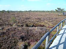
199:Central part of the moor
71:of the German states of
295:(Sphagnum magellanicum)
495:Franconian Saale basin
263:
211:, six kilometres from
200:
89:Rhön Biosphere Reserve
60:
48:
40:
32:
24:
432:Kaltensundheim, 1997.
261:
198:
176:50.51417°N 10.06500°E
130:The Black Moor is an
46:
38:
30:
22:
99:. It is part of the
371:Die Hochrhönstraße.
344:Die Moore der Rhön.
314:Die Moore der Rhön.
292:Magellan's Peatmoss
172: /
16:Highmoor in Germany
264:
201:
181:50.51417; 10.06500
49:
41:
33:
25:
520:Bogs of Thuringia
409:978-3-768-20857-4
364:978-3-631-45093-2
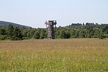
31:Observation tower
527:
384:Heribert Kramm:
317:
310:
276:vicar cooperator
262:The moor pathway
223:, ST 2287, from
205:Lower Franconian
187:
186:
184:
183:
182:
177:
173:
170:
169:
168:
165:
83:. It is part of
535:
534:
530:
529:
528:
526:
525:
524:
510:Bogs of Bavaria
480:
479:
454:
325:
320:
311:
307:
303:
286:, wrote in his
256:
193:
180:
178:
174:
171:
166:
163:
161:
159:
158:
17:
12:
11:
5:
533:
531:
523:
522:
517:
512:
507:
502:
497:
492:
490:Rhön Mountains
482:
481:
478:
477:
472:
467:
461:
453:
452:External links
450:
449:
448:
433:
426:
419:
412:
399:Theodor Gies:
397:
382:
367:
355:
342:Willy Kiefer:
340:
333:
324:
321:
319:
318:
312:Willy Kiefer:
304:
302:
299:
255:
252:
240:drainage basin
229:sea level (NN)
217:High Rhön Road
192:
189:
109:Central Europe
65:Rhön Mountains
61:Schwarzes Moor
23:The Black Moor
15:
13:
10:
9:
6:
4:
3:
2:
532:
521:
518:
516:
515:Bogs of Hesse
513:
511:
508:
506:
505:Rhön-Grabfeld
503:
501:
498:
496:
493:
491:
488:
487:
485:
476:
473:
471:
468:
465:
462:
459:
456:
455:
451:
446:
445:3-9802436-2-1
442:
438:
434:
431:
427:
424:
420:
417:
413:
410:
406:
402:
398:
395:
394:3-7900-0305-0
391:
387:
386:Die Hochrhön.
383:
380:
379:3-7900-0149-X
376:
372:
368:
365:
361:
356:
353:
352:3-7900-0269-0
349:
345:
341:
338:
334:
331:
327:
326:
322:
315:
309:
306:
300:
298:
296:
293:
289:
285:
281:
280:Simmershausen
277:
273:
269:
260:
253:
251:
249:
245:
241:
237:
232:
230:
226:
222:
218:
214:
210:
206:
197:
190:
188:
185:
156:
154:
150:
145:
141:
137:
136:cupola-shaped
133:
128:
126:
122:
118:
114:
110:
106:
102:
98:
94:
90:
86:
82:
78:
74:
70:
66:
62:
58:
54:
45:
37:
29:
21:
436:
429:
422:
415:
400:
385:
370:
369:Max Mölter:
343:
336:
329:
313:
308:
294:
287:
265:
233:
202:
157:
152:
129:
127:in Bavaria.
115:between the
52:
50:
500:Werra basin
244:River Rhine
219:and on the
179: /
144:rectangular
105:Natura 2000
484:Categories
414:Udo Bohn:
323:Literature
301:References
284:naturalist
221:state road
207:parish of
164:50°30′51″N
140:kermi bogs
97:raised bog
53:Black Moor
272:High Rhön
213:Fladungen
167:10°3′54″E
153:Schlenken
132:eccentric
113:watershed
77:Thuringia
316:page 10.
268:Red Moor
225:Seiferts
191:Location
125:geotopes
93:hectares
69:tripoint
242:of the
215:on the
81:Bavaria
67:at the
47:Drosera
443:
407:
392:
377:
362:
350:
248:Ulster
209:Hausen
149:flarks
101:Europe
85:UNESCO
57:German
332:2003.
236:Streu
121:Weser
117:Rhine
73:Hesse
39:Flark
441:ISBN
405:ISBN
390:ISBN
375:ISBN
360:ISBN
348:ISBN
254:Name
119:and
79:and
51:The
278:of
87:'s
486::
134:,
75:,
59::
447:.
411:.
396:.
381:.
366:.
354:.
151:(
55:(
Text is available under the Creative Commons Attribution-ShareAlike License. Additional terms may apply.