419:
641:
405:
252:
40:
508:: 'lake of the small peak') is the smaller and more westerly of two natural lakes within the Black Mountain. It is enclosed within a rock hollow formed as a result of glacial action during the ice ages. It is about 500 yards long and 200 yards wide, and roughly oriented east-west. It is drained by the Afon Sawdde which cuts through a
611:
traverses the range roughly from east to west. Increased use of certain sections of path by walkers in recent years has resulted in accelerated erosion, a problem exacerbated by the sometimes thin, gravelly soils and the high rainfall, and has prompted repairs by the
543:
towards the eastern end of the mountain. It is of similar glacial origin to its westerly neighbour, but is slightly larger. It is about 600 yards long and 200 yards wide, being roughly oriented north south. It is drained by a stream known as Nant y Llyn
429:
The massif is drained by a number of rivers which flow down the southern dip-slopes of the massif from its main ridge. In contrast the northerly directed streams tend to be shorter and steeper. The upper parts of the range are largely
964:
173:
563:
road, where there is a small space for cars to park. There is another small car park a short distance away to the south and next to the same road at the end of another footpath to the lake.
900:
579:, making the centre of the range even more inaccessible. There are several small car parks on the minor roads crossing the range, and a larger car park on the minor road from
865:
836:
724:
The Black
Mountain is generally considered to be one of the wildest regions of Wales and is associated with numerous myths such as the Arthurian legend of the
212:. The most resistant of all are the Plateau beds, which form a protective cap over most of the range. They also form steep cliffs just below the edge of the
732:. More recent events are commemorated in prose and verse, e.g. 'From the Mist to Heaven' written after a tragedy played out on these moors in May 1904.
148:) is sometimes used inaccurately to describe the whole of this massif, whereas it should be restricted to the peaks along the northern escarpment within
925:
418:
592:
974:
969:
904:
392:
and upland Welsh moorland in the centre and north of the country. All such moorlands are tree-less in their upper parts, in their current
712:. The skylark is plentiful due to the extensive rough pasture present below the main peaks which allows ground nesting of the species.
692:. The kestrel and buzzard are widely distributed, but the raven is restricted to the higher mountains. There is a wide distribution of
278:
are also remnants of glacial action, having been created by other moraines blocking drainage by forming deep hollows below the cliffs.
620:
on the high and middle ground, although some are bridged by stone pavements. There is a well graded stone staircase which carries the
102:
in the east of the
National Park, nor with a 703 metres (2,306 ft) summit in the Black Mountains that is confusingly also called
979:
817:
236:
are to be found beneath the spectacular north and east facing sandstone scarps in the north-east of the range, especially below
571:
Parts of the massif are over 5 km or over 3 miles from the nearest public road. Indeed, those roads are mostly very minor
376:
elsewhere in
Britain was in a similar condition, and extensive Bronze Age remains have been found there too. Examples include
512:
which in part forms a natural dam. A small artificial dam was constructed in the 1930s to divert some of its waters to boost
833:
580:
524:
489:
which sit directly below the main escarpment, being much larger than the small lake of similar origin which occurs below
328:
outside the circle nearby, known as Maen Mawr, with two smaller stones forming a small avenue. There is also evidence of
613:
79:
736:
on its southeastern margin is sometimes known locally as the
Sleeping Giant, after the appearance of its profile from
676:
to name a few of the most obvious residents. The red kite was previously restricted to this and adjoining areas in
133:
in the wider modern sense of that term, thus also including the Black
Mountains and the intervening high ground of
779:
470:, a tributary of the Loughor, are the principal southerly-directed watercourses. Two left-bank tributaries of the
348:
on Fan Foel showed it to be of early Bronze Age in date (circa 2000 BC) and there is a very similar unexcavated
208:) are important landscape-forming rocks in the south and west of the range owing to their greater resistance to
555:
The lake can be reached on foot by an approximately 1.7 mile (2.7 km) walk across the moor from the minor
197:
114:
749:
640:
293:
99:
31:
103:
527:, although the road to the car park is poorly signposted, and in very poor condition for car travel.
87:
458:
arises at the western end of the range. Significant right bank tributaries of the Tawe such as the
688:
in the rest of the country, but has since been introduced widely in southern
Britain, such as the
286:
There are many surviving remains, especially prehistoric and Roman, in the area. They include the
361:
404:
813:
572:
193:
523:
The lake can easily be reached by foot from the car park on the water board access road near
17:
725:
673:
517:
329:
176:
of
Carmarthenshire is thus the minor summit of Fan Foel, height 781 metres (2,562 ft).
840:
705:
629:
625:
584:
540:
536:
509:
501:
443:
408:
275:
271:
259:
255:
201:
161:
153:
149:
83:
67:
43:
364:
owing to a warmer climate than at present, with much of the present moorland covered by
754:
681:
661:
657:
600:
545:
505:
325:
221:
205:
157:
145:
130:
75:
63:
55:
454:
have their sources on the northern and eastern flanks of the range whilst the smaller
958:
576:
455:
423:
729:
713:
669:
665:
588:
552:. The surface of Llyn y Fan Fawr lies at about 1980 feet or 605 m above sea level.
486:
475:
349:
345:
313:
309:
241:
169:
134:
759:
677:
621:
608:
604:
479:
467:
459:
385:
337:
297:
189:
111:
652:
There are numerous different species of bird in the area, and they include the
591:
and hence legally accessible to the public on foot under the provisions of the
890:
Ordnance Survey
Explorer map OL12 'Brecon Beacons National Park: western area'
737:
697:
685:
549:
471:
463:
451:
393:
333:
317:
301:
267:
251:
213:
122:
940:
927:
66:
in South, Mid and West Wales, straddling the administrative boundary between
709:
689:
596:
556:
490:
447:
185:
86:
at 802 metres or 2,631 ft. The Black
Mountain also forms a part of the
595:. In addition the range is crossed from north to south by a number of long
733:
653:
645:
617:
560:
513:
438:, some of which is degrading judging by the partly destroyed sections of
435:
431:
412:
389:
377:
373:
357:
353:
245:
217:
165:
126:
39:
787:
701:
693:
321:
237:
233:
229:
225:
209:
830:
The
Itinerary in Wales of John Leland in or about the years 1536-1539
716:
are common near the streams and torrents running from the hill tops.
381:
305:
288:
118:
843:
Containing Part 6 (The Itinerary in Wales), with a Map, London, 1906
240:. There are smaller moraines lying immediately below the cliffs of
639:
417:
403:
365:
341:
250:
71:
38:
192:
in the north-east. The larger part of these hills is formed from
965:
Sites of Special Scientific Interest in Carmarthen & Dinefwr
607:
though long sections of them are very rough and indistinct. The
439:
369:
324:, and is known as Cerrig Duon, or "black stones". There is a
74:(as well as the county boundary between Carmarthenshire and
587:. Virtually the entire massif consists of land mapped as
316:. An especially famous circle occurs on the banks of the
516:'s water supply. Llyn y Fan Fach is associated with the
30:
For the range in southeast Wales and Herefordshire, see
852:
Ordnance Survey 1:25,000 scale Explorer map sheet OL12
482:, drain the northwestern slopes of the Black Mountain.
172:. The highest point of the "Carmarthen Fans" and the
548:: 'stream of the lake'), whose waters flow into the
98:The Black Mountain should not be confused with the
780:"Geopark — Brecon Beacons National Park Authority"
356:. The excavation at Fan Foel indicated that the
220:, in common with their companion peaks of the
27:Mountain range, west of Brecon Beacons, Wales
8:
539:or lake of the large peak, which lies below
78:) and forming the westernmost range of the
854:Brecon Beacons National Park: western area
583:village to the base of the access road to
901:"Geopark Timeline — Fforest Fawr Geopark"
872:. Brecon Beacons National Park Authority
771:
422:The Black Mountain range seen from the
184:The range stretches approximately from
160:). The "Carmarthen Fans" thus includes
614:Brecon Beacons National Park Authority
593:Countryside and Rights of Way Act 2000
129:i.e. what is now considered to be the
46:the highest peak on the Black Mountain
485:The range is noted for its two large
7:
25:
156:lies east across the border into
372:at lower heights. Most current
812:Gwasg Carreg Gwalch, Llanrwst
411:lake below the escarpment and
1:
18:Black Mountain (range), Wales
975:Mountains and hills of Powys
970:Landforms of Carmarthenshire
632:in the centre of the range.
140:The term "Carmarthen Fans" (
80:Brecon Beacons National Park
828:Toulmin Smith, Lucy (ed.),
996:
224:to the east. The area was
106:. In his description of a
29:
340:. Recent excavation of a
300:crossing Fforest Fawr as
980:Mountain ranges of Wales
684:owing to persecution by
839:April 28, 2016, at the
216:. The rocks are of the
198:Carboniferous Limestone
82:. Its highest point is
649:
426:
415:
294:Mynydd Bach Trecastell
263:
232:and a number of fresh
59:
47:
32:Black Mountains, Wales
784:www.breconbeacons.org
720:Cultural associations
643:
628:up the escarpment to
616:. There are numerous
599:which may be used by
421:
407:
388:, much of the upland
304:. There are numerous
262:in the Black Mountain
254:
188:in the south-west to
42:
941:51.88144°N 3.70848°W
870:Fforest Fawr Geopark
810:Place-names of Gwent
266:The lakes below the
88:Fforest Fawr Geopark
937: /
644:Side view of adult
360:was well-wooded in
946:51.88144; -3.70848
790:on 4 December 2008
650:
573:single track roads
427:
416:
362:Bronze Age Britain
312:and several small
264:
196:, though bands of
121:extending between
48:
808:Morgan, R. 2005.
466:, as well as the
434:and covered with
330:human settlements
194:Old Red Sandstone
16:(Redirected from
987:
952:
951:
949:
948:
947:
942:
938:
935:
934:
933:
930:
917:
916:
914:
912:
903:. Archived from
897:
891:
888:
882:
881:
879:
877:
862:
856:
850:
844:
826:
820:
806:
800:
799:
797:
795:
786:. Archived from
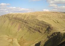
776:
726:Lady of the Lake
708:as well as many
518:Lady of the Lake
21:
995:
994:
990:
989:
988:
986:
985:
984:
955:
954:
945:
943:
939:
936:
931:
928:
926:
924:
923:
921:
920:
910:
908:
907:on 16 July 2011
899:
898:
894:
889:
885:
875:
873:
864:
863:
859:
851:
847:
841:Wayback Machine
827:
823:
807:
803:
793:
791:
778:
777:
773:
768:
750:Black Mountains
746:
722:
638:
630:Fan Brycheiniog
626:Llyn y Fan Fawr
601:mountain bikers
585:Llyn y Fan Fach
569:
541:Fan Brycheiniog
537:Llyn y Fan Fawr
533:
531:Llyn y Fan Fawr
510:glacial moraine
502:Llyn y Fan Fach
499:
497:Llyn y Fan Fach
444:Llyn y Fan Fawr
409:Llyn y Fan Fach
402:
284:
276:Llyn y Fan Fach
272:Llyn y Fan Fawr
260:Fan Brycheiniog
256:Llyn y Fan Fawr
202:Twrch Sandstone
182:
154:Fan Brycheiniog
150:Carmarthenshire
100:Black Mountains
96:
84:Fan Brycheiniog
68:Carmarthenshire
44:Fan Brycheiniog
35:
28:
23:
22:
15:
12:
11:
5:
993:
991:
983:
982:
977:
972:
967:
957:
956:
919:
918:
892:
883:
857:
845:
821:
801:
770:
769:
767:
764:
763:
762:
757:
755:Brecon Beacons
752:
745:
742:
740:to the south.
721:
718:
682:Mynydd Mallaen
658:common buzzard
637:
634:
577:passing places
568:
565:
532:
529:
498:
495:
401:
398:
326:standing stone
283:
280:
222:Brecon Beacons
206:Millstone Grit
181:
178:
158:Brecknockshire
142:Bannau Sir Gâr
131:Brecon Beacons
104:Black Mountain
95:
92:
76:Brecknockshire
64:mountain range
52:Black Mountain
26:
24:
14:
13:
10:
9:
6:
4:
3:
2:
992:
981:
978:
976:
973:
971:
968:
966:
963:
962:
960:
953:
950:
906:
902:
896:
893:
887:
884:
871:
867:
861:
858:
855:
849:
846:
842:
838:
835:
831:
825:
822:
819:
818:0-86381-956-7
815:
811:
805:
802:
789:
785:
781:
775:
772:
765:
761:
758:
756:
753:
751:
748:
747:
743:
741:
739:
735:
731:
727:
719:
717:
715:
714:Pied wagtails
711:
707:
703:
699:
695:
691:
687:
683:
679:
675:
671:
667:
663:
659:
655:
647:
642:
635:
633:
631:
627:
623:
619:
615:
610:
606:
602:
598:
594:
590:
586:
582:
578:
574:
566:
564:
562:
558:
553:
551:
547:
542:
538:
530:
528:
526:
521:
519:
515:
511:
507:
503:
496:
494:
492:
488:
487:glacial lakes
483:
481:
477:
473:
469:
465:
461:
457:
453:
449:
446:. The rivers
445:
441:
437:
433:
425:
424:Usk Reservoir
420:
414:
410:
406:
399:
397:
395:
391:
387:
383:
379:
375:
371:
367:
363:
359:
355:
351:
347:
343:
339:
335:
331:
327:
323:
319:
315:
314:stone circles
311:
310:round barrows
307:
303:
299:
295:
291:
290:
281:
279:
277:
273:
269:
261:
257:
253:
249:
247:
243:
239:
235:
231:
227:
223:
219:
215:
211:
207:
203:
199:
195:
191:
187:
179:
177:
175:
171:
167:
163:
159:
155:
152:(the peak of
151:
147:
143:
138:
136:
132:
128:
124:
120:
116:
113:
109:
108:Blak Montayne
105:
101:
93:
91:
89:
85:
81:
77:
73:
69:
65:
61:
57:
53:
45:
41:
37:
33:
19:
922:
911:30 September
909:. Retrieved
905:the original
895:
886:
874:. Retrieved
869:
866:"Reservoirs"
860:
853:
848:
829:
824:
809:
804:
792:. Retrieved
788:the original
783:
774:
730:Twrch Trwyth
723:
670:common raven
666:carrion crow
651:
589:open country
581:Llanddeusant
570:
554:
534:
525:Llanddeusant
522:
500:
484:
476:River Cennen
428:
350:round barrow
346:round barrow
287:
285:
265:
242:Waun Lefrith
183:
170:Waun Lefrith
141:
139:
135:Fforest Fawr
117:refers to a
107:
97:
51:
49:
36:
944: /
876:29 December
760:South Wales
698:field voles
686:gamekeepers
678:South Wales
622:Beacons Way
609:Beacons Way
605:horseriders
575:with a few
480:Afon Sawdde
468:River Amman
460:River Giedd
386:Bodmin Moor
368:scrub with
338:agriculture
334:hut circles
282:Archaeology
228:during the
190:Sennybridge
115:John Leland
112:antiquarian
60:Y Mynydd Du
959:Categories
929:51°52′53″N
794:13 January
766:References
624:path from
597:bridleways
550:River Tawe
472:River Towy
464:Afon Twrch
442:bank near
394:sub-arctic
318:River Tawe
302:Sarn Helen
298:Roman road
268:escarpment
214:escarpment
174:county top
123:Carmarthen
932:3°42′31″W
710:songbirds
702:red foxes
690:Chilterns
618:peat bogs
557:Trecastle
535:The lake
491:Pen y Fan
226:glaciated
186:Ammanford
837:Archived
744:See also
738:Cwm Tawe
734:Cribarth
696:such as
680:such as
654:red kite
646:red kite
636:Wildlife
561:Abercraf
520:legend.
514:Llanelli
478:and the
462:and the
436:peat bog
432:moorland
413:Picws Du
400:Drainage
390:Pennines
378:Dartmoor
374:moorland
358:moorland
354:Picws Du
258:, below
246:Picws Du
234:moraines
230:ice ages
218:Devonian
166:Picws Du
162:Fan Foel
127:Monmouth
706:badgers
694:mammals
674:skylark
662:kestrel
648:, Wales
456:Loughor
396:state.
322:Fan Hir
306:menhirs
238:Fan Hir
210:erosion
200:and of
180:Geology
62:) is a
834:Vol. 3
816:
567:Access
474:, the
382:Exmoor
320:below
296:and a
289:castra
119:massif
110:, the
546:Welsh
506:Welsh
366:hazel
342:cairn
292:s at
146:Welsh
72:Powys
56:Welsh
913:2010
878:2021
814:ISBN
796:2022
728:and
704:and
672:and
603:and
452:Tawe
450:and
440:peat
336:and
274:and
244:and
204:(or
168:and
125:and
94:Name
70:and
50:The
559:to
448:Usk
370:oak
352:on
344:or
270:of
144:in
961::
868:.
832:,
782:.
700:,
668:,
664:,
660:,
656:,
493:.
384:,
380:,
332:,
308:,
248:.
164:,
137:.
90:.
58::
915:.
880:.
798:.
544:(
504:(
54:(
34:.
20:)
Text is available under the Creative Commons Attribution-ShareAlike License. Additional terms may apply.