600:
59:
583:
713:
638:
304:
626:
288:
395:
652:
614:
312:
296:
43:
66:
360:
once covered the Unley region of the
Adelaide Plains. The woodland forest was a mix of grey-box, blue gum, red gum, native pines and sheoak trees, with grass trees, native grasses and orchids. These plants had deep roots that held the soil together and the plant debris that fell on the earth
453:
Black Forest
Primary School opened in 1919. It is located off South Road and School Avenue, between Forest Avenue and Addison Road. The east end of the school grounds are adjacent to the "Forest Avenue Reserve".
486:
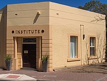
The
Clarence Park Community Centre is located in the Institute Building and surrounding buildings on the corner of East Avenue and Canterbury Terrace. The centre includes a childcare facility and a men's shed.
818:
599:
199:
187:
1056:
1178:
582:
58:
91:
175:
625:
789:
1049:
637:
512:
Black Forest is serviced by three tram stops, two train stations and buses on East Avenue and South Road. All services are run by the
712:
981:
872:
690:
426:
1082:
1042:
725:
271:
266:
366:
In the early years of colonial settlement, the Black Forest was supposedly "frequented by bush rangers and cattle thieves".
845:
1087:
643:
544:
1173:
1132:
1092:
651:
535:
239:
234:
192:
84:
613:
1147:
1117:
1127:
1112:
1097:
1152:
1137:
1107:
1102:
246:
225:
1122:
670:
548:
216:
988:. Dept. for Transport, Energy and Infrastructure, Public Transport Division. 12 January 2011. Archived from
657:
568:
540:
1142:
876:
694:
146:
130:
429:
counted 1,846 persons in Black Forest on census night. Of these, 47.2% were male and 52.8% were female.
381:
in 1966, and the third, located on South Road between Byron and Cowper Roads, opened on 8 January 1996.
944:
303:
339:
168:
754:
432:
The majority of residents (79.0%) are of
Australian birth, with other common census responses being
956:
478:
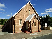
The
Uniting Church History Centre is based in the former Church of Christ building on East Avenue.
204:
968:
287:
785:
556:
335:
804:
466:
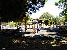
is located on Forest Avenue near the centre of the suburb. There is another small park, the
311:
295:
327:
33:
901:
408:
Please help update this article to reflect recent events or newly available information.
525:
513:
989:
1167:
1066:
331:
180:
230:
729:
261:
1034:
923:
42:
588:
563:
501:
343:
106:
93:
254:
323:
29:
433:
437:
310:
302:
294:
286:
1038:
377:
in 1915, the second opened on 10 November 1947 and was renamed
388:
1015:
819:"The A-Z story of the history behind Adelaide's suburbs"
373:: the first opened on 1 September 1899 and was renamed
631:
South Road Tram level crossing - prior to the overpass
524:
198:
186:
174:
163:
155:
145:
137:
122:
83:
23:
356:"A dense area of bush known as the Black Forest
211:
902:"The Manning Index of South Australian History"
361:decomposed releasing nutrients into the soil."
291:Entrance to the Clarence Park Community Centre
1050:
8:
749:
747:
127:
1057:
1043:
1035:
755:"Black Forest, South Australia (Adelaide)"
711:
518:
41:
20:
867:
865:
863:
529:
521:
504:, and to a lesser degree by East Avenue.
369:There have been three Post Offices named
782:Adelaide and surrounds street directory
682:
578:
776:
774:
772:
259:
244:
223:
213:
7:
1179:Populated places established in 1850
695:"Black Forest (suburb and locality)"
605:South Road overpass over Cross Road,
65:
18:Suburb of Adelaide, South Australia
904:. State Library of South Australia
159:1.63 km (0.6 sq mi)
14:
699:Australian Census 2021 QuickStats
470:, at the east end of Byron Road.
650:
636:
624:
612:
598:
581:
393:
64:
57:
986:Adelaide Metro official website
873:Australian Bureau of Statistics
728:. City of Unley. Archived from
691:Australian Bureau of Statistics
427:Australian Bureau of Statistics
346:(west) and East Avenue (east).
322:is an inner southern suburb of
982:"Public Transport in Adelaide"
957:Clarence Park Community Centre
926:. Australian Schools Directory
924:"Australian Schools Directory"
167:4.7 km (3 mi) SW of
1:
947:, community.history.sa.gov.au
945:Uniting Church History Centre
877:"Black Forest (State Suburb)"
817:Tim Bowden (9 October 2013).
644:Clarence Park railway station
545:Adelaide Entertainment Centre
474:Uniting Church History Centre
315:Uniting Church History Centre
784:(47th ed.). UBD. 2009.
500:Black Forest is serviced by
468:Princess Margaret Playground
299:Princess Margaret Playground
1195:
444:Facilities and attractions
1073:
848:. Premier Postal Auctions
757:. Postcodes-Australia.com
591:overpass over Cross Road,
402:This section needs to be
277:
214:
210:
52:
40:
844:Premier Postal History.
671:List of Adelaide suburbs
619:South Road Tram Overpass
358:('Kertaweeta' in Kuarna)
658:Emerson railway station
541:Royal Adelaide Hospital
425:The 2006 Census by the
330:. It is located in the
307:Wayville Baptist Church
881:2006 Census QuickStats
316:
308:
300:
292:
726:"How Unley Developed"
464:Forest Avenue Reserve
314:
306:
298:
290:
47:Forest Avenue Reserve
340:Seaford railway line
219:around Black Forest:
169:Adelaide city centre
1174:Suburbs of Adelaide
875:(25 October 2007).
732:on 27 December 2008
200:Federal division(s)
188:State electorate(s)
103: /
846:"Post Office List"
530:Following station
522:Preceding station
379:Clarence Park West
338:(north-west), the
317:
309:
301:
293:
107:34.964°S 138.576°E
1161:
1160:
969:Community Centres
959:, sacommunity.org
791:978-0-7319-2336-6
575:
574:
557:Glenelg tram line
423:
422:
336:Glenelg tram line
334:, bounded by the
285:
284:
281:
280:
1186:
1059:
1052:
1045:
1036:
1031:
1029:
1027:
1020:Official website
1002:
1001:
999:
997:
992:on 26 April 2011
978:
972:
966:
960:
954:
948:
942:
936:
935:
933:
931:
920:
914:
913:
911:
909:
898:
892:
891:
889:
887:
869:
858:
857:
855:
853:
841:
835:
834:
832:
830:
814:
808:
802:
796:
795:
778:
767:
766:
764:
762:
751:
742:
741:
739:
737:
722:
716:
715:
709:
707:
705:
693:(28 June 2022).
687:
654:
640:
628:
616:
602:
585:
519:
508:Public transport
482:Community Centre
418:
415:
409:
397:
396:
389:
212:
129:
118:
117:
115:
114:
113:
112:-34.964; 138.576
108:
104:
101:
100:
99:
96:
68:
67:
61:
45:
36:
26:
21:
1194:
1193:
1189:
1188:
1187:
1185:
1184:
1183:
1164:
1163:
1162:
1157:
1069:
1065:Suburbs of the
1063:
1025:
1023:
1022:. City of Unley
1016:"City of Unley"
1014:
1011:
1006:
1005:
995:
993:
980:
979:
975:
971:, City of Unley
967:
963:
955:
951:
943:
939:
929:
927:
922:
921:
917:
907:
905:
900:
899:
895:
885:
883:
871:
870:
861:
851:
849:
843:
842:
838:
828:
826:
816:
815:
811:
807:, City of Unley
803:
799:
792:
780:
779:
770:
760:
758:
753:
752:
745:
735:
733:
724:
723:
719:
703:
701:
689:
688:
684:
679:
667:
660:
655:
646:
641:
632:
629:
620:
617:
608:
606:
603:
594:
592:
586:
571:
551:
510:
498:
493:
484:
476:
460:
451:
446:
419:
413:
410:
407:
398:
394:
387:
352:
328:South Australia
111:
109:
105:
102:
97:
94:
92:
90:
89:
79:
78:
77:
76:
75:
74:
73:
69:
48:
34:South Australia
28:
27:
24:
19:
12:
11:
5:
1192:
1190:
1182:
1181:
1176:
1166:
1165:
1159:
1158:
1156:
1155:
1150:
1145:
1140:
1135:
1130:
1125:
1120:
1115:
1110:
1105:
1100:
1095:
1090:
1085:
1080:
1074:
1071:
1070:
1064:
1062:
1061:
1054:
1047:
1039:
1033:
1032:
1010:
1009:External links
1007:
1004:
1003:
973:
961:
949:
937:
915:
893:
859:
836:
823:The Advertiser
809:
797:
790:
768:
743:
717:
681:
680:
678:
675:
674:
673:
666:
663:
662:
661:
656:
649:
647:
642:
635:
633:
630:
623:
621:
618:
611:
609:
604:
597:
595:
587:
580:
573:
572:
569:Moseley Square
566:
561:
559:
554:
552:
549:Festival Plaza
538:
532:
531:
528:
526:Adelaide Metro
523:
514:Adelaide Metro
509:
506:
497:
494:
492:
489:
483:
480:
475:
472:
459:
456:
450:
447:
445:
442:
421:
420:
401:
399:
392:
386:
383:
364:
363:
351:
348:
342:(south-east),
283:
282:
279:
278:
275:
274:
269:
264:
258:
257:
252:
249:
243:
242:
237:
228:
222:
221:
208:
207:
202:
196:
195:
190:
184:
183:
178:
172:
171:
165:
161:
160:
157:
153:
152:
149:
143:
142:
139:
135:
134:
124:
120:
119:
87:
81:
80:
71:
70:
63:
62:
56:
55:
54:
53:
50:
49:
46:
38:
37:
17:
13:
10:
9:
6:
4:
3:
2:
1191:
1180:
1177:
1175:
1172:
1171:
1169:
1154:
1151:
1149:
1146:
1144:
1141:
1139:
1136:
1134:
1131:
1129:
1126:
1124:
1121:
1119:
1116:
1114:
1111:
1109:
1106:
1104:
1101:
1099:
1096:
1094:
1091:
1089:
1086:
1084:
1083:Clarence Park
1081:
1079:
1076:
1075:
1072:
1068:
1067:City of Unley
1060:
1055:
1053:
1048:
1046:
1041:
1040:
1037:
1021:
1017:
1013:
1012:
1008:
991:
987:
983:
977:
974:
970:
965:
962:
958:
953:
950:
946:
941:
938:
925:
919:
916:
903:
897:
894:
882:
878:
874:
868:
866:
864:
860:
847:
840:
837:
824:
820:
813:
810:
806:
801:
798:
793:
787:
783:
777:
775:
773:
769:
756:
750:
748:
744:
731:
727:
721:
718:
714:
700:
696:
692:
686:
683:
676:
672:
669:
668:
664:
659:
653:
648:
645:
639:
634:
627:
622:
615:
610:
601:
596:
593:looking south
590:
584:
579:
577:
570:
565:
562:
560:
558:
555:
553:
550:
546:
542:
537:
534:
533:
527:
520:
517:
515:
507:
505:
503:
495:
490:
488:
481:
479:
473:
471:
469:
465:
457:
455:
448:
443:
441:
439:
435:
430:
428:
417:
405:
400:
391:
390:
384:
382:
380:
376:
372:
367:
362:
357:
354:
353:
349:
347:
345:
341:
337:
333:
332:City of Unley
329:
325:
321:
313:
305:
297:
289:
276:
273:
272:Clarence Park
270:
268:
267:Clarence Park
265:
263:
260:
256:
253:
250:
248:
245:
241:
238:
236:
232:
229:
227:
224:
220:
218:
209:
206:
203:
201:
197:
194:
191:
189:
185:
182:
181:City of Unley
179:
177:
173:
170:
166:
162:
158:
154:
150:
148:
144:
140:
136:
132:
125:
121:
116:
88:
86:
82:
60:
51:
44:
39:
35:
31:
22:
16:
1088:Everard Park
1078:Black Forest
1077:
1024:. Retrieved
1019:
994:. Retrieved
990:the original
985:
976:
964:
952:
940:
928:. Retrieved
918:
906:. Retrieved
896:
884:. Retrieved
880:
850:. Retrieved
839:
827:. Retrieved
822:
812:
800:
781:
759:. Retrieved
734:. Retrieved
730:the original
720:
702:. Retrieved
698:
685:
607:looking west
576:
511:
499:
485:
477:
467:
463:
461:
452:
431:
424:
411:
403:
385:Demographics
378:
374:
371:Black Forest
370:
368:
365:
359:
355:
320:Black Forest
319:
318:
251:Black Forest
231:Everard Park
215:
72:Black Forest
25:Black Forest
15:
1133:Myrtle Bank
1093:Forestville
908:8 September
536:Forestville
436:(3.1%) and
262:Edwardstown
240:Forestville
235:Forestville
147:Postcode(s)
138:Established
110: /
98:138°34′34″E
85:Coordinates
1168:Categories
1148:Unley Park
1118:Kings Park
825:. Adelaide
677:References
589:South Road
564:South Road
502:South Road
344:South Road
123:Population
95:34°57′50″S
1128:Millswood
1113:Hyde Park
1098:Fullarton
829:15 August
736:1 January
491:Transport
414:July 2019
255:Millswood
1153:Wayville
1138:Parkside
1108:Highgate
1103:Goodwood
1026:14 April
996:15 April
930:16 April
886:16 April
805:Our city
761:16 April
665:See also
567:towards
539:towards
440:(2.3%).
375:Glandore
324:Adelaide
247:Glandore
226:Glandore
164:Location
30:Adelaide
1123:Malvern
704:28 June
449:Schools
434:England
404:updated
350:History
217:Suburbs
205:Boothby
126:1,982 (
32:,
852:26 May
788:
710:
438:Greece
193:Badcoe
176:LGA(s)
1143:Unley
496:Roads
458:Parks
1028:2011
998:2011
932:2011
910:2011
888:2011
854:2011
831:2017
786:ISBN
763:2011
738:2011
706:2022
462:The
233:and
156:Area
151:5035
141:1850
131:2021
547:or
128:SAL
1170::
1018:.
984:.
879:.
862:^
821:.
771:^
746:^
697:.
543:,
516:.
326:,
1058:e
1051:t
1044:v
1030:.
1000:.
934:.
912:.
890:.
856:.
833:.
794:.
765:.
740:.
708:.
416:)
412:(
406:.
133:)
Text is available under the Creative Commons Attribution-ShareAlike License. Additional terms may apply.