391:
379:
367:
355:
583:
636:
407:
324:(17/35) is 3,600 ft × 60 ft (1,097 m × 18 m). It has two turf runways: 12/30 is 2,205 ft × 265 ft (672 m × 81 m) and 3/21 is 1,665 ft × 255 ft (507 m × 78 m).
410:
415:
413:
409:
408:
414:
412:
697:
390:
498:
476:
411:
620:
707:
673:
21:
613:
378:
309:, a longtime Concordia resident, aviation enthusiast, and former city mayor. It is on land originally owned by the Blosser family.
666:
366:
354:
287:
258:
87:
702:
343:
In 1930, Charlie
Blosser laid the first dirt airstrip on his farm. He later donated the land to the city for airport use.
606:
692:
659:
432:
397:
527:
462:
137:
327:
In the year ending July 24, 2007 the airport had 14,550 aircraft operations, average 39 per day: 97%
302:
458:
290:
90:
539:
306:
298:
279:
271:
129:
76:
65:
643:
590:
328:
318:
331:
and 3% military. Nine aircraft were then based at the airport: eight single-engine and one
555:
686:
559:
545:
332:
36:
23:
582:
565:
549:
635:
533:
321:
160:
147:
569:
642:
This article about a building or structure in Kansas is a
647:
594:
317:The airport covers 209 acres (85 ha); its one
243:
235:
226:
146:
135:
125:
117:
109:
104:
53:
698:Buildings and structures in Cloud County, Kansas
501:. Warsaw, Indiana Times-Union. September 7, 1978
667:
614:
477:"Blosser Spends His 84 Years High in the Sky"
305:, United States. The airport was named after
8:
421:Video panorama of airport from ground level
674:
660:
621:
607:
232:
50:
589:This Kansas airport-related article is a
444:
350:
479:. Fort Scott Tribune. November 7, 1979
454:
452:
450:
448:
16:Airport in Cloud County, Kansas, U.S.
7:
632:
630:
579:
577:
708:Kansas building and structure stubs
646:. You can help Knowledge (XXG) by
593:. You can help Knowledge (XXG) by
14:
400:Armory is in the airport complex.
634:
581:
499:"Tires Trouble Aerial Tradition"
405:
389:
377:
365:
353:
554:NOAA/NWS weather observations:
259:Federal Aviation Administration
116:
1:
459:FAA Airport Form 5010 for CNK
534:airport information for KCNK
523:Resources for this airport:
528:airport information for CNK
724:
629:
576:
433:List of airports in Kansas
398:Kansas Army National Guard
142:1,486 ft / 453 m
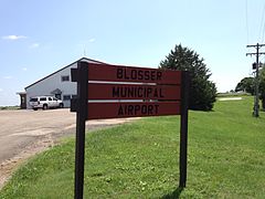
268:Blosser Municipal Airport
255:
231:
167:
164:
159:
155:
60:
55:Blosser Municipal Airport
540:accident history for CNK
297:) is two miles south of
466:, effective 2007-12-20
37:39.54917°N 97.65222°W
703:Kansas airport stubs
372:View of Airport Park
360:Airport welcome sign
303:Cloud County, Kansas
570:Terminal Procedures
550:live flight tracker
546:airport information
236:Aircraft operations
42:39.54917; -97.65222
33: /
693:Airports in Kansas
566:aeronautical chart
307:Charles H. Blosser
655:
654:
602:
601:
465:
416:
265:
264:
251:
250:
227:Statistics (2007)
222:
221:
130:Concordia, Kansas
121:City of Concordia
715:
676:
669:
662:
638:
631:
623:
616:
609:
585:
578:
511:
510:
508:
506:
495:
489:
488:
486:
484:
473:
467:
461:
456:
418:
417:
393:
381:
369:
357:
329:general aviation
233:
157:
156:
150:
97:
96:
83:
82:
72:
71:
51:
48:
47:
45:
44:
43:
38:
34:
31:
30:
29:
26:
723:
722:
718:
717:
716:
714:
713:
712:
683:
682:
681:
680:
628:
627:
560:past three days
520:
515:
514:
504:
502:
497:
496:
492:
482:
480:
475:
474:
470:
457:
446:
441:
429:
422:
419:
406:
401:
394:
385:
382:
373:
370:
361:
358:
349:
341:
315:
261:
148:
136:Elevation
100:
94:
86:
80:
75:
69:
64:
56:
41:
39:
35:
32:
27:
24:
22:
20:
19:
17:
12:
11:
5:
721:
719:
711:
710:
705:
700:
695:
685:
684:
679:
678:
671:
664:
656:
653:
652:
639:
626:
625:
618:
611:
603:
600:
599:
586:
575:
574:
573:
572:
562:
552:
542:
536:
530:
519:
518:External links
516:
513:
512:
490:
468:
443:
442:
440:
437:
436:
435:
428:
425:
424:
423:
420:
404:
402:
395:
388:
386:
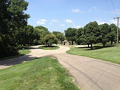
383:
376:
374:
371:
364:
362:
359:
352:
348:
345:
340:
337:
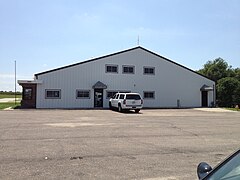
314:
311:
263:
262:
256:
253:
252:
249:
248:
245:
244:Based aircraft
241:
240:
237:
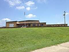
229:
228:
224:
223:
220:
219:
216:
213:
210:
206:
205:
202:
199:
196:
192:
191:
188:
185:
182:
178:
177:
174:
170:
169:
166:
163:
153:
152:
144:
143:
140:
133:
132:
127:
123:
122:
119:
115:
114:
111:
107:
106:
102:
101:
99:
98:
84:
73:
61:
58:
57:
54:
15:
13:
10:
9:
6:
4:
3:
2:
720:
709:
706:
704:
701:
699:
696:
694:
691:
690:
688:
677:
672:
670:
665:
663:
658:
657:
651:
649:
645:
640:
637:
633:
624:
619:
617:
612:
610:
605:
604:
598:
596:
592:
587:
584:
580:
571:
567:
563:
561:
557:
553:
551:
547:
543:
541:
537:
535:
531:
529:
525:
524:
522:
521:
517:
500:
494:
491:
478:
472:
469:
464:
460:
455:
453:
451:
449:
445:
438:
434:
431:
430:
426:
403:
399:
392:
387:
384:Main building
380:
375:
368:
363:
356:
351:
346:
344:
338:
336:
334:
330:
325:
323:
320:
312:
310:
308:
304:
300:
296:
292:
289:
285:
281:
277:
273:
269:
260:
254:
246:
242:
238:
234:
230:
225:
217:
214:
211:
208:
207:
203:
200:
197:
194:
193:
189:
186:
183:
180:
179:
175:
172:
171:
162:
158:
154:
151:
145:
141:
139:
134:
131:
128:
124:
120:
112:
108:
103:
92:
89:
85:
78:
74:
67:
63:
62:
59:
52:
49:
46:
648:expanding it
641:
595:expanding it
588:
544:FlightAware
503:. Retrieved
493:
481:. Retrieved
471:
342:
326:
316:
294:
283:
275:
267:
266:
110:Airport type
18:
40: /
28:097°39′08″W
687:Categories
564:SkyVector
439:References
333:ultralight
313:Facilities
25:39°32′57″N
505:August 7,
483:August 7,
299:Concordia
161:Direction
427:See also
257:Source:
190:Asphalt
168:Surface
556:current
532:AirNav
347:Gallery
339:History
319:asphalt
165:Length
149:Runways
105:Summary
322:runway
239:14,550
212:1,665
198:2,205
195:12/30
187:1,097
184:3,600
181:17/35
126:Serves
113:Public
301:, in
218:Turf
209:3/21
204:Turf
118:Owner
644:stub
591:stub
548:and
538:ASN
526:FAA
507:2013
485:2013
396:The
284:KCNK
280:ICAO
272:IATA
215:507
201:672
138:AMSL
81:KCNK
77:ICAO
66:IATA
463:PDF
295:CNK
291:LID
288:FAA
276:CNK
173:ft
95:CNK
91:LID
88:FAA
70:CNK
689::
568:,
558:,
447:^
335:.
293::
286:,
282::
278:,
274::
176:m
93::
79::
68::
675:e
668:t
661:v
650:.
622:e
615:t
608:v
597:.
509:.
487:.
270:(
247:9
Text is available under the Creative Commons Attribution-ShareAlike License. Additional terms may apply.