228:
185:
36:
172:
239:, which is likely to have been the site of Zouche's manor, an important estate of the family of the name la Zouche of Harringworth, who leased the land in the mid 14th century. For a while, among other names, Blow's down was eponymously referred to as Zouche's (or Souches) Downs, as seen in
255:
of the early 1800s would likely have drastically changed the appearance of Blow's Downs, due to hedges planted to separate fields. Around this time is when the Downs became known by the name they are known today, probably named after tenant farmers at Zouche's farm with the surname "Blow".
796:
1555:
267:, which opened in 1858, provided transportation of lime away from Blow's Down. The British Portland Cement Manufacturing Company acquired the lease to the site, and were still running the works during the 1920s. Production ceased some time before the
141:
The site has varied habitats with a large area of unimproved grassland, a scarce survival of this important habitat. Cattle help to maintain the pasture. Features include a disused quarry and medieval cultivation terraces. A rare plant,
782:
216:, the land would likely have been rented by the king, with the slopes of the downs being mainly used for grazing as they were too steep to plough. There is however, some evidence of crops being grown, namely the existence of
805:
135:
46:
1550:
535:
224:
during times of calm, with a tournament being held in 1214. The fields at the foot of Blow's Down would likely have made ideal locations for such mock battles of the time.
789:
620:
330:
101:
526:
295:
675:
264:
1511:
64:
220:, quite visible in the area now known as Cottage Bottom fields. Blow's Down was one of relatively few places in England permitted to hold
115:
27:
878:
1330:
918:
615:
236:
231:
Thomas
Jefferys' 1765 map of Bedfordshire, showing Dunstable as "Dunstaple" and the area now known as Blow's Down as "Souches Downs"
127:
933:
168:
There is access from Jeans Way in the north, from
Jardine Way and Half Moon Lane in the west, and from Skimpot Road in the east.
204:
identified several remains of neolithic huts, finding among other things a horse's bone and, in 1888, part of a human skeleton.
893:
565:
1493:
1385:
1355:
580:
1083:
131:
774:
1305:
1128:
984:
519:
512:
272:
200:
Blow's Down has a lengthy history, with evidence of human habitation dating back around 4000 years. The archeologist
1438:
555:
1478:
1463:
1380:
938:
908:
610:
585:
134:. The site forms around half of the 62.3-hectare (154-acre) Blow's Downs nature reserve, which is managed by the
1483:
1295:
1219:
1133:
201:
710:
680:
600:
302:
227:
184:
154:
263:
brought further, large changes to Blow's Downs. There is evidence of a limeworks on the Downs by 1901. The
251:
Throughout the 1800s and later, the Downs underwent several changes from human activity. The parliamentary
1365:
1287:
1068:
840:
590:
188:
A sketch of the sites of the remains of neolithic huts found on Blow's Down, from
Worthington G. Smith's
1400:
1360:
1315:
1171:
635:
221:
1335:
504:
1453:
1443:
1300:
1201:
870:
763:
720:
143:
1325:
1320:
1310:
1264:
1156:
1118:
1027:
999:
845:
753:
690:
650:
1458:
1433:
1340:
822:
213:
989:
1488:
1428:
1418:
1229:
1166:
1007:
953:
898:
883:
855:
748:
715:
408:
175:
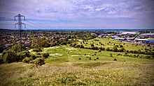
Northwest-facing view of
Dunstable from the viewpoint of Blow's Downs at sunset (August 2016).
88:
462:
375:
1448:
1423:
1408:
1390:
1278:
1259:
1186:
1161:
1138:
1098:
1037:
860:
685:
665:
655:
570:
35:
1350:
1176:
1060:
1045:
1017:
903:
695:
575:
240:
171:
158:
153:
Dunstable is built around Blow's Down, from the south around clockwise to the east. The
1473:
1254:
1234:
1191:
1123:
1108:
1103:
1012:
967:
850:
758:
725:
705:
700:
630:
162:
58:
1544:
1413:
1375:
1239:
1088:
1073:
948:
928:
923:
913:
830:
743:
640:
595:
1224:
1148:
1113:
1050:
813:
670:
645:
625:
539:
268:
260:
123:
51:
352:
430:
1370:
1244:
1181:
1078:
1022:
660:
605:
1468:
1249:
1209:
835:
735:
547:
1556:
Wildlife Trust for
Bedfordshire, Cambridgeshire and Northamptonshire reserves
1526:
1513:
1345:
1214:
1093:
976:
943:
252:
119:
301:. Sites of Special Scientific Interest. Natural England. Archived from
217:
355:. Wildlife Trust for Bedfordshire, Cambridgeshire and Northamptonshire
483:
806:
Wildlife Trust for
Bedfordshire, Cambridgeshire and Northamptonshire
136:
Wildlife Trust for
Bedfordshire, Cambridgeshire and Northamptonshire
157:
road follows a valley between the Blow's Down and the neighbouring
226:
183:
170:
470:
Dunstable & District Local
History Society Newsletter No. 46
778:
508:
40:
Northwest-facing view from the viewpoint at Blow's Downs SSSI.
416:
Dunstable
District Local History History Newsletter No. 43
114:(or Blow's Downs) is a 33.1-hectare (82-acre) biological
212:
Following the establishment of the town of
Dunstable by
333:. Sites of Special Scientific Interest. Natural England
1551:
Sites of Special Scientific Interest in Bedfordshire
1399:
1286:
1277:
1200:
1147:
1059:
1036:
998:
975:
966:
869:
821:
812:
734:
546:
97:
87:
79:
71:
57:
45:
126:. It was notified in 1989 under Section 28 of the
621:Kings Wood and Glebe Meadows, Houghton Conquest
374:Ltd, Copyright The mountain Guide-A.-Connect.
790:
520:
8:
21:
1283:
972:
818:
797:
783:
775:
527:
513:
505:
290:
288:
34:
20:
1187:Wansford Pasture & Standen's Pasture
16:Part of the Chiltern Hills, Bedfordshire
676:Smithcombe, Sharpenhoe and Sundon Hills
284:
271:, with the chalk pit being used by the
138:. It has a maximum elevation of 212 m.
259:In the early 20th century, commercial
130:, and the local planning authority is
325:
323:
161:, which together make up part of the
7:
536:Sites of Special Scientific Interest
402:
400:
398:
396:
646:Maulden Wood and Pennyfather's Hill
116:Site of Special Scientific Interest
28:Site of Special Scientific Interest
879:Arlesey Old Moat and Glebe Meadows
429:Smith, Worthington George (1894).
14:
1331:Irthlingborough Lakes and Meadows
616:Kings and Bakers Woods and Heaths
128:Wildlife and Countryside Act 1981
919:King's Wood and Rammamere Heath
407:Turner, David (February 2015).
1:
1474:Pitsford Water Nature Reserve
1356:Short Wood and Southwick Wood
581:Dunstable and Whipsnade Downs
484:"Bedfordshire Sheet XXXII.NE"
235:At the top of the downs lies
488:National Library of Scotland
132:Central Bedfordshire Council
1306:Ditchford Lakes and Meadows
1129:Waresley and Gransden Woods
1572:
243:1765 map of Bedfordshire.
150:can be found at the site.
939:Pegsdon Hills and Hoo Bit
909:Fancott Woods and Meadows
611:Houghton Regis Marl Lakes
586:Fancott Woods and Meadows
265:Luton-Dunstable rail link
190:Man, the Primeval Savage.
33:
26:
1484:Stoke Bruerne Brick Pits
1296:Barford Wood and Meadows
985:Cherry Hinton Chalk Pits
432:Man, The Primeval Savage
711:Totternhoe Chalk Quarry
681:Southill Lake and Woods
601:Galley and Warden Hills
376:"Blow's Down | England"
1366:Stoke Wood End Quarter
1316:Glapthorn Cow Pastures
1288:North Northamptonshire
841:Felmersham Gravel Pits
591:Felmersham Gravel Pits
461:Turner, David (2016).
448:Defending Bedfordshire
446:Osborne, Mike (2021).
296:"Blow's Down citation"
232:
192:
176:
1401:West Northamptonshire
1361:Southfield Farm Marsh
1172:Stanground Newt Ponds
636:Maulden Church Meadow
463:"Blow's Downs Update"
230:
187:
174:
1454:High Wood and Meadow
1444:Grafton Regis Meadow
1301:Collyweston Quarries
1202:South Cambridgeshire
871:Central Bedfordshire
764:Totternhoe Stone Pit
721:Wavendon Heath Ponds
331:"Map of Blow's Down"
275:as a training area.
202:Worthington G. Smith
144:Bunium bulbocastanum
1523: /
1326:Higham Ferrers Pits
1321:Great Oakley Meadow
1311:Finedon Cally Banks
1265:Trumpington Meadows
1157:Dogsthorpe Star Pit
1000:East Cambridgeshire
846:Pavenham Osier Beds
754:Kensworth Chalk Pit
691:Sundon Chalk Quarry
651:Nares Gladley Marsh
435:. pp. 323–325.
418:. pp. 320–321.
23:
1459:Kingsthorpe Meadow
1434:Duston Mill Meadow
233:
193:
177:
1506:
1505:
1502:
1501:
1419:Boddington Meadow
1273:
1272:
1230:Gamlingay Cinques
1167:Southorpe Paddock
1008:Chettisham Meadow
962:
961:
934:Old Warden Tunnel
899:Cut-throat Meadow
884:Barton Gravel Pit
856:Sharnbrook Summit
772:
771:
749:Double Arches Pit
716:Totternhoe Knolls
450:. Fonthill Media.
380:UK mountain Guide
247:1800s and onwards
148:Odontaeus armiger
109:
108:
1563:
1538:
1537:
1535:
1534:
1533:
1528:
1527:51.883°N 0.502°W
1524:
1521:
1520:
1519:
1516:
1449:Harlestone Heath
1429:Bugbrooke Meadow
1424:Bradlaugh Fields
1409:Abington Meadows
1284:
1279:Northamptonshire
1162:Southorpe Meadow
1139:Woodwalton Marsh
1119:Shepherd's Close
1099:Houghton Meadows
973:
861:Wymington Meadow
819:
799:
792:
785:
776:
686:Stevington Marsh
666:Pulloxhill Marsh
656:Odell Great Wood
529:
522:
515:
506:
499:
498:
496:
494:
480:
474:
473:
467:
458:
452:
451:
443:
437:
436:
426:
420:
419:
413:
404:
391:
390:
388:
386:
371:
365:
364:
362:
360:
349:
343:
342:
340:
338:
327:
318:
317:
315:
313:
307:
300:
292:
269:Second World War
261:chalk extraction
67:
38:
24:
1571:
1570:
1566:
1565:
1564:
1562:
1561:
1560:
1541:
1540:
1531:
1529:
1525:
1522:
1517:
1514:
1512:
1510:
1509:
1507:
1498:
1395:
1351:Rothwell Gullet
1269:
1260:Shepreth L Moor
1196:
1177:Stanground Wash
1143:
1069:Arthur's Meadow
1061:Huntingdonshire
1055:
1032:
994:
990:Skaters' Meadow
958:
904:Dropshort Marsh
865:
808:
803:
773:
768:
730:
696:Swineshead Wood
576:Dropshort Marsh
542:
533:
503:
502:
492:
490:
482:
481:
477:
465:
460:
459:
455:
445:
444:
440:
428:
427:
423:
411:
406:
405:
394:
384:
382:
373:
372:
368:
358:
356:
351:
350:
346:
336:
334:
329:
328:
321:
311:
309:
308:on 4 March 2016
305:
298:
294:
293:
286:
281:
249:
210:
208:Medieval period
198:
182:
159:Dunstable Downs
63:
41:
17:
12:
11:
5:
1569:
1567:
1559:
1558:
1553:
1543:
1542:
1532:51.883; -0.502
1504:
1503:
1500:
1499:
1497:
1496:
1494:Woodford Halse
1491:
1489:Storton's Pits
1486:
1481:
1479:Ramsden Corner
1476:
1471:
1466:
1461:
1456:
1451:
1446:
1441:
1436:
1431:
1426:
1421:
1416:
1411:
1405:
1403:
1397:
1396:
1394:
1393:
1388:
1386:Wicksteed Park
1383:
1378:
1373:
1368:
1363:
1358:
1353:
1348:
1343:
1338:
1333:
1328:
1323:
1318:
1313:
1308:
1303:
1298:
1292:
1290:
1281:
1275:
1274:
1271:
1270:
1268:
1267:
1262:
1257:
1255:Overhall Grove
1252:
1247:
1242:
1237:
1235:Gamlingay Wood
1232:
1227:
1222:
1217:
1212:
1206:
1204:
1198:
1197:
1195:
1194:
1192:Woodston Ponds
1189:
1184:
1179:
1174:
1169:
1164:
1159:
1153:
1151:
1145:
1144:
1142:
1141:
1136:
1131:
1126:
1124:Upwood Meadows
1121:
1116:
1111:
1109:Pingle Cutting
1106:
1101:
1096:
1091:
1086:
1081:
1076:
1071:
1065:
1063:
1057:
1056:
1054:
1053:
1048:
1042:
1040:
1034:
1033:
1031:
1030:
1025:
1020:
1015:
1013:Doghouse Grove
1010:
1004:
1002:
996:
995:
993:
992:
987:
981:
979:
970:
968:Cambridgeshire
964:
963:
960:
959:
957:
956:
951:
946:
941:
936:
931:
926:
921:
916:
911:
906:
901:
896:
891:
886:
881:
875:
873:
867:
866:
864:
863:
858:
853:
851:Sewell Cutting
848:
843:
838:
833:
827:
825:
816:
810:
809:
804:
802:
801:
794:
787:
779:
770:
769:
767:
766:
761:
759:Nine Acres Pit
756:
751:
746:
740:
738:
732:
731:
729:
728:
726:Yelden Meadows
723:
718:
713:
708:
706:Tilwick Meadow
703:
701:Tebworth Marsh
698:
693:
688:
683:
678:
673:
668:
663:
658:
653:
648:
643:
638:
633:
631:Marston Thrift
628:
623:
618:
613:
608:
603:
598:
593:
588:
583:
578:
573:
568:
563:
558:
552:
550:
544:
543:
534:
532:
531:
524:
517:
509:
501:
500:
475:
472:. p. 335.
453:
438:
421:
409:"Blow's Downs"
392:
366:
353:"Blow's Downs"
344:
319:
283:
282:
280:
277:
248:
245:
218:strip lynchets
209:
206:
197:
194:
181:
178:
163:Chiltern Hills
107:
106:
99:
95:
94:
91:
85:
84:
81:
77:
76:
73:
69:
68:
61:
59:Grid reference
55:
54:
49:
43:
42:
39:
31:
30:
15:
13:
10:
9:
6:
4:
3:
2:
1568:
1557:
1554:
1552:
1549:
1548:
1546:
1539:
1536:
1495:
1492:
1490:
1487:
1485:
1482:
1480:
1477:
1475:
1472:
1470:
1467:
1465:
1462:
1460:
1457:
1455:
1452:
1450:
1447:
1445:
1442:
1440:
1437:
1435:
1432:
1430:
1427:
1425:
1422:
1420:
1417:
1415:
1414:Barnes Meadow
1412:
1410:
1407:
1406:
1404:
1402:
1398:
1392:
1391:Wilson's Pits
1389:
1387:
1384:
1382:
1379:
1377:
1376:Tailby Meadow
1374:
1372:
1369:
1367:
1364:
1362:
1359:
1357:
1354:
1352:
1349:
1347:
1344:
1342:
1339:
1337:
1334:
1332:
1329:
1327:
1324:
1322:
1319:
1317:
1314:
1312:
1309:
1307:
1304:
1302:
1299:
1297:
1294:
1293:
1291:
1289:
1285:
1282:
1280:
1276:
1266:
1263:
1261:
1258:
1256:
1253:
1251:
1248:
1246:
1243:
1241:
1240:Hardwick Wood
1238:
1236:
1233:
1231:
1228:
1226:
1223:
1221:
1218:
1216:
1213:
1211:
1208:
1207:
1205:
1203:
1199:
1193:
1190:
1188:
1185:
1183:
1180:
1178:
1175:
1173:
1170:
1168:
1165:
1163:
1160:
1158:
1155:
1154:
1152:
1150:
1146:
1140:
1137:
1135:
1132:
1130:
1127:
1125:
1122:
1120:
1117:
1115:
1112:
1110:
1107:
1105:
1102:
1100:
1097:
1095:
1092:
1090:
1089:Grafham Water
1087:
1085:
1084:Godmanchester
1082:
1080:
1077:
1075:
1074:Brampton Wood
1072:
1070:
1067:
1066:
1064:
1062:
1058:
1052:
1049:
1047:
1044:
1043:
1041:
1039:
1035:
1029:
1026:
1024:
1021:
1019:
1018:Fordham Woods
1016:
1014:
1011:
1009:
1006:
1005:
1003:
1001:
997:
991:
988:
986:
983:
982:
980:
978:
974:
971:
969:
965:
955:
952:
950:
949:Sallowsprings
947:
945:
942:
940:
937:
935:
932:
930:
929:Landpark Wood
927:
925:
924:Lancot Meadow
922:
920:
917:
915:
914:Flitwick Moor
912:
910:
907:
905:
902:
900:
897:
895:
894:Cooper's Hill
892:
890:
887:
885:
882:
880:
877:
876:
874:
872:
868:
862:
859:
857:
854:
852:
849:
847:
844:
842:
839:
837:
834:
832:
831:Begwary Brook
829:
828:
826:
824:
820:
817:
815:
811:
807:
800:
795:
793:
788:
786:
781:
780:
777:
765:
762:
760:
757:
755:
752:
750:
747:
745:
744:Biddenham Pit
742:
741:
739:
737:
733:
727:
724:
722:
719:
717:
714:
712:
709:
707:
704:
702:
699:
697:
694:
692:
689:
687:
684:
682:
679:
677:
674:
672:
669:
667:
664:
662:
659:
657:
654:
652:
649:
647:
644:
642:
641:Maulden Heath
639:
637:
634:
632:
629:
627:
624:
622:
619:
617:
614:
612:
609:
607:
604:
602:
599:
597:
596:Flitwick Moor
594:
592:
589:
587:
584:
582:
579:
577:
574:
572:
569:
567:
566:Cooper's Hill
564:
562:
559:
557:
554:
553:
551:
549:
545:
541:
537:
530:
525:
523:
518:
516:
511:
510:
507:
489:
485:
479:
476:
471:
464:
457:
454:
449:
442:
439:
434:
433:
425:
422:
417:
410:
403:
401:
399:
397:
393:
381:
377:
370:
367:
354:
348:
345:
332:
326:
324:
320:
304:
297:
291:
289:
285:
278:
276:
274:
270:
266:
262:
257:
254:
246:
244:
242:
238:
237:Zouche's farm
229:
225:
223:
219:
215:
207:
205:
203:
196:Neolothic era
195:
191:
186:
179:
173:
169:
166:
164:
160:
156:
151:
149:
146:, and beetle
145:
139:
137:
133:
129:
125:
121:
117:
113:
105:
104:
100:
96:
92:
90:
86:
83:33.1 hectares
82:
78:
74:
70:
66:
62:
60:
56:
53:
50:
48:
44:
37:
32:
29:
25:
19:
1508:
1225:Fulbourn Fen
1149:Peterborough
1114:Raveley Wood
1051:Norwood Road
1028:Soham Meadow
889:Blow's Downs
888:
814:Bedfordshire
671:Sandy Warren
626:Knocking Hoe
560:
556:Barton Hills
540:Bedfordshire
491:. Retrieved
487:
478:
469:
456:
447:
441:
431:
424:
415:
383:. Retrieved
379:
369:
357:. Retrieved
347:
335:. Retrieved
310:. Retrieved
303:the original
258:
250:
234:
211:
199:
189:
167:
152:
147:
140:
124:Bedfordshire
111:
110:
102:
98:Location map
89:Notification
52:Bedfordshire
18:
1530: /
1439:Farthinghoe
1371:Summer Leys
1341:Old Sulehay
1336:King's Wood
1245:Hayley Wood
1182:Thorpe Wood
1134:Wistow Wood
1104:Lady's Wood
1079:Gamsey Wood
1023:Ouse Washes
661:Potton Wood
606:Hanger Wood
571:Deacon Hill
561:Blow's Down
222:tournaments
112:Blow's Down
22:Blow's Down
1545:Categories
1515:51°52′59″N
1469:Mill Crook
1381:Titchmarsh
1250:Lower Wood
1210:Beechwoods
954:Totternhoe
836:Cople Pits
736:Geological
548:Biological
279:References
273:Home Guard
253:enclosures
75:Biological
1518:0°30′07″W
1346:The Plens
1220:Cambourne
1215:Buff Wood
1094:Great Fen
1046:Lattersey
977:Cambridge
944:The Riddy
359:24 August
337:24 August
312:24 August
241:Jefferys'
120:Dunstable
103:Magic Map
493:4 August
385:3 August
72:Interest
65:TL033214
47:Location
1038:Fenland
823:Bedford
214:Henry I
180:History
165:range.
1464:Lings
466:(PDF)
412:(PDF)
306:(PDF)
299:(PDF)
495:2023
387:2023
361:2015
339:2015
314:2015
93:1989
80:Area
538:in
122:in
118:in
1547::
486:.
468:.
414:.
395:^
378:.
322:^
287:^
155:A5
798:e
791:t
784:v
528:e
521:t
514:v
497:.
389:.
363:.
341:.
316:.
Text is available under the Creative Commons Attribution-ShareAlike License. Additional terms may apply.