55:
250:
31:
258:
62:
288:
has undertaken a Dam Safety
Assurance program for Bluestone. The DSA project includes raising the dam by 8 feet (2.4 m), installing anchors and thrust blocks to tie the dam into bedrock, spillway improvements and other work. The first phase of the project was completed in October 2004. The
705:
284:
In recent years, it was discovered that
Bluestone Dam would be unable to pass the Probable Maximum Flood possible at the site, which could cause failure of the dam. To remedy the problem, the
740:
700:
735:
730:
695:
690:
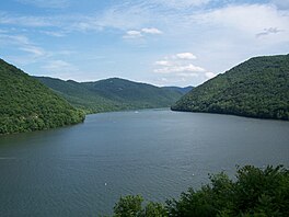
237:. Normally approximately 2,040 acres (8.3 km) in size, the lake can grow to over 36 miles (58 km) long at flood control pool. At higher water levels, the lake extends into
715:
725:
675:
54:
557:
318:
298:
630:
415:
685:
406:
233:, West Virginia. At its normal pool level, Bluestone Dam impounds a 10.7-mile (17.2 km) stretch of the New and its tributary, the
335:
306:
101:
720:
680:
411:
270:
277:
in the Flood
Control Acts of 1936 and 1938. Construction of the project was begun in early 1941, suspended in 1944 because of
710:
522:
492:
462:
375:
285:
269:
Rivers. The dam is 165 feet (50 m) high and 2,048 feet (624 m) long. The dam was authorized by
Presidential
289:
second phase, installing bedrock anchors, was completed in 2011. Three additional phases remain to be constructed.
265:
The lake is formed by
Bluestone Dam, a concrete gravity dam located just upstream of the confluence of the New and
297:
Due to its large size, Bluestone Lake provides many recreational opportunities including boating and fishing. The
526:
496:
466:
379:
340:
226:
150:
401:
604:
441:
309:, each encompassing portions of the lake. Camping and other activities are available in these facilities.
238:
230:
209:
249:
30:
330:
302:
36:
548:
143:
518:
458:
583:
488:
266:
234:
40:
257:
157:
669:
274:
222:
133:
83:
660:
371:
278:
116:
103:
579:
87:
281:. Work resumed in 1946, and completed for operational purposes in 1949.
144:
256:
248:
631:"West Virginia DNR creates 5 new state fishing record categories"
635:
16:
Reservoir located on the New River near Hinton, West
Virginia
706:
United States Army Corps of
Engineers, Huntington District
519:"Construction of Bluestone Dam: Phase II (1945–1949)"
489:"Construction of Bluestone Dam: Phase I (1941–1944)"
205:
201:
193:
185:
181:
166:
156:
142:
132:
93:
79:
23:
440:(Map). 1:24,000. 7.5-Minute Series (Topographic).
741:Bodies of water of Summers County, West Virginia
701:Protected areas of Summers County, West Virginia
94:
736:Bodies of water of Monroe County, West Virginia
731:Bodies of water of Mercer County, West Virginia
696:Protected areas of Monroe County, West Virginia
691:Protected areas of Mercer County, West Virginia
8:
558:West Virginia Division of Natural Resources
299:West Virginia Division of Natural Resources
716:United States Army Corps of Engineers dams
661:US Army Corps of Engineers: Bluestone Lake
438:Narrows, Virginia-West Virginia quadrangle
20:
726:Bodies of water of Giles County, Virginia
676:Protected areas of Giles County, Virginia
416:United States Department of the Interior
366:
364:
362:
360:
358:
356:
352:
321:were caught along the Bluestone Lake.
162:4,565 sq mi (11,820 km)
61:
453:
451:
7:
407:Geographic Names Information System
550:Bluestone Wildlife Management Area
336:Bluestone Wildlife Management Area
307:Bluestone Wildlife Management Area
14:
60:
53:
29:
605:"West Virginia Fishing Records"
580:"West Virginia Fishing Records"
412:United States Geological Survey
319:West Virginia stage record fish
192:
184:
629:Kirk, Sam (January 10, 2024).
253:Aerial view of the dam in 2011
1:
78:
523:U.S. Army Corps of Engineers
493:U.S. Army Corps of Engineers
463:U.S. Army Corps of Engineers
376:U.S. Army Corps of Engineers
286:U.S. Army Corps of Engineers
273:in 1935 and approved by the
686:Reservoirs in West Virginia
189:10.7 mi (17.2 km)
757:
225:reservoir located on the
197:2,040 acres (830 ha)
48:
39:marina, at the point the
28:
261:Front of the dam in 2006
35:Bluestone Lake near the
721:Dams completed in 1949
681:Reservoirs in Virginia
442:U.S. Geological Survey
262:
254:
711:Dams in West Virginia
260:
252:
117:37.64028°N 80.88583°W
331:Bluestone State Park
303:Bluestone State Park
37:Bluestone State Park
122:37.64028; -80.88583
113: /
560:. January 29, 2007
263:
255:
584:West Virginia DNR
216:
215:
170:January 1952
748:
648:
647:
645:
643:
626:
620:
619:
617:
615:
601:
595:
594:
592:
590:
576:
570:
569:
567:
565:
555:
545:
539:
538:
536:
534:
515:
509:
508:
506:
504:
485:
479:
478:
476:
474:
455:
446:
445:
434:
428:
427:
425:
423:
402:"Bluestone Lake"
398:
392:
391:
389:
387:
372:"Bluestone Lake"
368:
177:
175:
146:
128:
127:
125:
124:
123:
118:
114:
111:
110:
109:
106:
96:
64:
63:
57:
33:
21:
756:
755:
751:
750:
749:
747:
746:
745:
666:
665:
657:
652:
651:
641:
639:
628:
627:
623:
613:
611:
603:
602:
598:
588:
586:
578:
577:
573:
563:
561:
553:
547:
546:
542:
532:
530:
517:
516:
512:
502:
500:
487:
486:
482:
472:
470:
459:"Bluestone DSA"
457:
456:
449:
436:
435:
431:
421:
419:
418:. June 27, 1980
400:
399:
395:
385:
383:
370:
369:
354:
349:
327:
315:
295:
271:Executive Order
247:
235:Bluestone River
212:, West Virginia
173:
171:
145:Primary inflows
121:
119:
115:
112:
107:
104:
102:
100:
99:
75:
74:
73:
72:
71:
70:
69:
65:
44:
41:Bluestone River
17:
12:
11:
5:
754:
752:
744:
743:
738:
733:
728:
723:
718:
713:
708:
703:
698:
693:
688:
683:
678:
668:
667:
664:
663:
656:
655:External links
653:
650:
649:
621:
596:
571:
540:
510:
480:
447:
429:
393:
351:
350:
348:
345:
344:
343:
338:
333:
326:
323:
314:
311:
294:
291:
246:
243:
219:Bluestone Lake
214:
213:
207:
203:
202:
199:
198:
195:
191:
190:
187:
183:
182:
179:
178:
168:
164:
163:
160:
158:Catchment area
154:
153:
148:
140:
139:
136:
130:
129:
97:
91:
90:
81:
77:
76:
68:Bluestone Lake
67:
66:
59:
58:
52:
51:
50:
49:
46:
45:
34:
26:
25:
24:Bluestone Lake
15:
13:
10:
9:
6:
4:
3:
2:
753:
742:
739:
737:
734:
732:
729:
727:
724:
722:
719:
717:
714:
712:
709:
707:
704:
702:
699:
697:
694:
692:
689:
687:
684:
682:
679:
677:
674:
673:
671:
662:
659:
658:
654:
638:
637:
632:
625:
622:
610:
609:Land Big Fish
606:
600:
597:
585:
581:
575:
572:
559:
552:
551:
544:
541:
528:
524:
520:
514:
511:
498:
494:
490:
484:
481:
468:
464:
460:
454:
452:
448:
443:
439:
433:
430:
417:
413:
409:
408:
403:
397:
394:
381:
377:
373:
367:
365:
363:
361:
359:
357:
353:
346:
342:
339:
337:
334:
332:
329:
328:
324:
322:
320:
312:
310:
308:
304:
300:
292:
290:
287:
282:
280:
276:
275:U.S. Congress
272:
268:
259:
251:
245:Bluestone Dam
244:
242:
240:
236:
232:
228:
224:
223:flood control
220:
211:
208:
204:
200:
196:
188:
180:
169:
165:
161:
159:
155:
152:
149:
147:
141:
137:
135:
131:
126:
98:
92:
89:
85:
84:West Virginia
82:
56:
47:
42:
38:
32:
27:
22:
19:
640:. Retrieved
634:
624:
612:. Retrieved
608:
599:
587:. Retrieved
574:
562:. Retrieved
549:
543:
531:. Retrieved
513:
501:. Retrieved
483:
471:. Retrieved
437:
432:
420:. Retrieved
405:
396:
384:. Retrieved
316:
296:
283:
279:World War II
264:
241:, Virginia.
239:Giles County
218:
217:
194:Surface area
18:
206:Settlements
186:Max. length
120: /
95:Coordinates
670:Categories
642:August 25,
614:August 25,
589:August 25,
527:Huntington
497:Huntington
467:Huntington
380:Huntington
347:References
293:Recreation
267:Greenbrier
108:80°53′09″W
105:37°38′25″N
564:March 27,
533:March 27,
503:March 27,
473:March 27,
422:March 27,
386:March 27,
341:New River
317:Multiple
301:operates
227:New River
151:New River
138:Reservoir
43:enters it
529:District
499:District
469:District
382:District
325:See also
88:Virginia
80:Location
556:(Map).
444:. 1985.
313:Fishing
174:1952-01
172: (
231:Hinton
210:Hinton
554:(PDF)
229:near
221:is a
167:Built
644:2024
636:WBOY
616:2024
591:2024
566:2010
535:2010
505:2010
475:2010
424:2010
388:2010
305:and
134:Type
672::
633:.
607:.
582:.
525:.
521:.
495:.
491:.
465:.
461:.
450:^
414:,
410:.
404:.
378:,
374:.
355:^
646:.
618:.
593:.
568:.
537:.
507:.
477:.
426:.
390:.
176:)
86:/
Text is available under the Creative Commons Attribution-ShareAlike License. Additional terms may apply.