68:
52:
888:
316:
75:
243:
Simiutaq is not an outlying island; it would have been a continuation of the landmass in the north were it not for the narrow and shallow
Amerlunnguaq Strait, which branches to the west off Kangerlussuaq Fjord near the mouth of the latter. Simiutaq is roughly triangular in shape, mostly hilly, with
315:
455:
550:
228:, separated from the mainland by the Amerluunguaq Strait in the north, and by the main arm of the Kangerlussuaq Fjord in the southeast. Its name is a generic
543:
1417:
365:
452:
536:
67:
113:
204:
sail into
Kangerlussuaq Fjord south of the island. The fjord is navigable in its entire length, with the ships mooring at the
1248:
325:
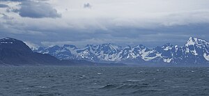
The northern end of
Simiutaq Island in the mouth of Kangerlussuaq Fjord, seen in bad weather from the Sarfaq Ittuk ship of
507:
416:
309:, located on a small island on the shores of Davis Strait, approximately 26 km (16 mi) south of the island.
1277:
470:
1324:
1313:
1261:
31:
1412:
209:
1063:
1269:
1164:
1159:
1154:
1149:
963:
1341:
1096:
182:
1336:
940:
914:
794:
568:
1017:
983:
900:
771:
616:
326:
322:
193:
173:
is a 13 km × 10 km (8.1 mi × 6.2 mi) uninhabited island in the
30:"Simiutaq" redirects here. For the island in Kujalleq municipality, southwest Greenland, see
1391:
1285:
1126:
1121:
1101:
862:
789:
348:
953:
51:
1187:
1174:
1131:
1111:
1106:
1073:
1068:
1033:
1006:
671:
621:
598:
459:
244:
low undulating plain in the north, and the highest point at 775 m (2,542.7 ft).
846:
1363:
1116:
1091:
1058:
1053:
727:
1406:
1317:
1236:
872:
666:
205:
1383:
1256:
1204:
1182:
359:
225:
101:
973:
750:
661:
201:
528:
17:
1215:
927:
737:
701:
691:
676:
656:
641:
334:
306:
381:
367:
128:
115:
1373:
1300:
1290:
887:
836:
828:
709:
631:
585:
178:
958:
358:
West Nine (BW-9) during the time of
American operation in Greenland during
232:
name for an island at the head of a fjord. It should not be confused with
1368:
1329:
1308:
1223:
1141:
867:
812:
799:
758:
745:
651:
626:
593:
330:
237:
233:
968:
841:
820:
784:
719:
681:
636:
174:
162:
354:
The "Cruncher Island" light and radio beacon, commonly referred to as
779:
763:
686:
213:
197:
216:
in the mouth of the fjord, at the southern end of
Simiutaq Island.
56:
Southern end of
Simiutaq Island at the mouth of Kangerlussuaq Fjord
1083:
1045:
603:
411:
355:
229:
646:
611:
482:
532:
362:, was a wartime radio communications facility located at
1382:
1356:
1299:
1247:
1232:
1200:
1173:
1140:
1082:
1044:
1029:
1002:
982:
939:
913:
896:
855:
811:
736:
718:
700:
584:
564:
158:
144:
107:
97:
92:
42:
544:
8:
37:
337:voyage alongside the coast of Davis Strait.
1244:
1041:
910:
581:
551:
537:
529:
36:
251:
428:
224:The island is located on the shores of
436:
434:
432:
7:
508:"Joint Committee Annual Report 2011"
181:, located in the mouth of the long
185:. It was also known informally as
25:
1418:Uninhabited islands of Greenland
886:
513:. United States State Department
314:
74:
73:
66:
50:
443:, Saga Map, Tage Schjøtt, 1992
1:
559:Abandoned sites in Greenland
417:List of islands of Greenland
1434:
346:
305:The closest settlement is
240:) in southwest Greenland.
212:. There are several small
196:and cruise ships, such as
29:
883:
149:
61:
49:
44:Nickname: Cruncher Island
347:Not to be confused with
177:municipality in western
856:outside municipalities
32:Simiutaq, SW Greenland
991:Farm ruins discovered
210:Kangerlussuaq Airport
129:66.06667°N 53.54167°W
402:on Simiutak Island.
1020:(Kangerluarsoruseq)
377: /
183:Kangerlussuaq Fjord
134:66.06667; -53.54167
125: /
39:
27:Island of Greenland
772:Kangerluarsoruseq
458:2010-05-09 at the
1400:
1399:
1357:Polar exploration
1352:
1351:
1196:
1195:
998:
997:
984:Middle Settlement
901:Greenlandic Norse
881:
880:
453:Hurtigruten.co.uk
382:66.050°N 53.600°W
327:Arctic Umiaq Line
298:
297:
266:Northwestern Cape
194:Royal Arctic Line
168:
167:
16:(Redirected from
1425:
1392:Deltaterrasserne
1345:
1333:
1321:
1281:
1273:
1265:
1245:
1219:
1127:Bluie West Eight
1122:Bluie West Seven
1102:Bluie West Three
1064:Bluie East Three
1042:
1021:
1018:Føroyingahavnin
946:
945:
931:
920:
919:
911:
904:Norsemen/Vikings
891:
890:
863:Clavering Island
832:
824:
803:
775:
767:
754:
607:
582:
553:
546:
539:
530:
523:
522:
520:
518:
512:
504:
498:
497:
495:
493:
479:
473:
468:
462:
450:
444:
438:
401:
400:
398:
397:
396:
394:
389:
388:
383:
378:
375:
374:
373:
370:
349:Bluie West Three
318:
252:
192:Supply ships of
140:
139:
137:
136:
135:
130:
126:
123:
122:
121:
118:
77:
76:
70:
54:
40:
21:
1433:
1432:
1428:
1427:
1426:
1424:
1423:
1422:
1403:
1402:
1401:
1396:
1378:
1348:
1339:
1327:
1311:
1295:
1279:
1278:Friedrichsthal
1271:
1263:
1241:
1228:
1217:
1209:
1192:
1188:Camp Fistclench
1175:Project Iceworm
1169:
1136:
1132:Bluie West Nine
1112:Bluie West Five
1107:Bluie West Four
1078:
1074:Bluie East Five
1069:Bluie East Four
1038:
1025:
1019:
1011:
994:
978:
943:
942:
935:
929:
917:
916:
907:
903:
892:
885:
877:
851:
830:
822:
807:
801:
773:
765:
752:
732:
714:
696:
672:Qernertuarssuit
605:
599:Appaalissiorfik
578:
571:
560:
557:
527:
526:
516:
514:
510:
506:
505:
501:
491:
489:
481:
480:
476:
469:
465:
460:Wayback Machine
451:
447:
439:
430:
425:
408:
392:
390:
387:66.050; -53.600
386:
384:
380:
379:
376:
371:
368:
366:
364:
363:
352:
345:
340:
339:
338:
324:
319:
303:
250:
222:
187:Cruncher Island
171:Simiutaq Island
154:
133:
131:
127:
124:
119:
116:
114:
112:
111:
88:
87:
86:
85:
84:
83:
82:
78:
57:
45:
35:
28:
23:
22:
18:Bluie West Nine
15:
12:
11:
5:
1431:
1429:
1421:
1420:
1415:
1405:
1404:
1398:
1397:
1395:
1394:
1388:
1386:
1380:
1379:
1377:
1376:
1371:
1366:
1360:
1358:
1354:
1353:
1350:
1349:
1347:
1346:
1342:Lille Koldewey
1334:
1322:
1305:
1303:
1297:
1296:
1294:
1293:
1288:
1283:
1275:
1267:
1259:
1253:
1251:
1242:
1240:
1239:
1233:
1230:
1229:
1227:
1226:
1221:
1212:
1210:
1208:
1207:
1201:
1198:
1197:
1194:
1193:
1191:
1190:
1185:
1179:
1177:
1171:
1170:
1168:
1167:
1162:
1157:
1152:
1146:
1144:
1138:
1137:
1135:
1134:
1129:
1124:
1119:
1117:Bluie West Six
1114:
1109:
1104:
1099:
1097:Bluie West Two
1094:
1092:Bluie West One
1088:
1086:
1080:
1079:
1077:
1076:
1071:
1066:
1061:
1059:Bluie East Two
1056:
1054:Bluie East One
1050:
1048:
1039:
1037:
1036:
1030:
1027:
1026:
1024:
1023:
1014:
1012:
1010:
1009:
1003:
1000:
999:
996:
995:
993:
992:
988:
986:
980:
979:
977:
976:
971:
966:
961:
956:
950:
948:
937:
936:
934:
933:
930:(Kilaarsarfik)
924:
922:
908:
906:
905:
897:
894:
893:
884:
882:
879:
878:
876:
875:
870:
865:
859:
857:
853:
852:
850:
849:
844:
839:
834:
826:
817:
815:
809:
808:
806:
805:
797:
792:
787:
782:
777:
769:
761:
756:
748:
742:
740:
734:
733:
731:
730:
728:Nipisat Island
724:
722:
716:
715:
713:
712:
706:
704:
698:
697:
695:
694:
689:
684:
679:
674:
669:
664:
659:
654:
649:
644:
639:
634:
629:
624:
619:
617:Comer's Midden
614:
609:
601:
596:
590:
588:
579:
577:
576:
573:
565:
562:
561:
558:
556:
555:
548:
541:
533:
525:
524:
499:
474:
463:
445:
427:
426:
424:
421:
420:
419:
414:
407:
404:
344:
341:
321:
320:
313:
312:
311:
302:
299:
296:
295:
292:
289:
285:
284:
281:
278:
274:
273:
270:
267:
263:
262:
259:
256:
249:
246:
221:
218:
208:port, west of
166:
165:
160:
156:
155:
150:
147:
146:
145:Administration
142:
141:
109:
105:
104:
99:
95:
94:
90:
89:
80:
79:
72:
71:
65:
64:
63:
62:
59:
58:
55:
47:
46:
43:
26:
24:
14:
13:
10:
9:
6:
4:
3:
2:
1430:
1419:
1416:
1414:
1411:
1410:
1408:
1393:
1390:
1389:
1387:
1385:
1381:
1375:
1372:
1370:
1367:
1365:
1362:
1361:
1359:
1355:
1343:
1338:
1335:
1331:
1326:
1323:
1319:
1318:Sabine Island
1315:
1310:
1307:
1306:
1304:
1302:
1298:
1292:
1289:
1287:
1284:
1282:
1280:(Narsarmijit)
1276:
1274:
1268:
1266:
1260:
1258:
1255:
1254:
1252:
1250:
1246:
1243:
1238:
1235:
1234:
1231:
1225:
1222:
1220:
1214:
1213:
1211:
1206:
1203:
1202:
1199:
1189:
1186:
1184:
1181:
1180:
1178:
1176:
1172:
1166:
1163:
1161:
1158:
1156:
1153:
1151:
1148:
1147:
1145:
1143:
1139:
1133:
1130:
1128:
1125:
1123:
1120:
1118:
1115:
1113:
1110:
1108:
1105:
1103:
1100:
1098:
1095:
1093:
1090:
1089:
1087:
1085:
1081:
1075:
1072:
1070:
1067:
1065:
1062:
1060:
1057:
1055:
1052:
1051:
1049:
1047:
1043:
1040:
1035:
1032:
1031:
1028:
1022:
1016:
1015:
1013:
1008:
1005:
1004:
1001:
990:
989:
987:
985:
981:
975:
972:
970:
967:
965:
962:
960:
957:
955:
952:
951:
949:
947:
944:(Eystribyggð)
938:
932:
926:
925:
923:
921:
918:(Vestribyggð)
912:
909:
902:
899:
898:
895:
889:
874:
873:Sabine Island
871:
869:
866:
864:
861:
860:
858:
854:
848:
845:
843:
840:
838:
835:
833:
827:
825:
823:(Lichtenfels)
819:
818:
816:
814:
810:
804:
798:
796:
793:
791:
788:
786:
783:
781:
778:
776:
774:(Færingehavn)
770:
768:
762:
760:
757:
755:
749:
747:
744:
743:
741:
739:
735:
729:
726:
725:
723:
721:
717:
711:
708:
707:
705:
703:
699:
693:
690:
688:
685:
683:
680:
678:
675:
673:
670:
668:
667:Qaqortuatsiaq
665:
663:
660:
658:
655:
653:
650:
648:
645:
643:
640:
638:
635:
633:
630:
628:
625:
623:
620:
618:
615:
613:
610:
608:
602:
600:
597:
595:
592:
591:
589:
587:
583:
580:
574:
570:
567:
566:
563:
554:
549:
547:
542:
540:
535:
534:
531:
509:
503:
500:
488:
484:
478:
475:
472:
467:
464:
461:
457:
454:
449:
446:
442:
437:
435:
433:
429:
422:
418:
415:
413:
410:
409:
405:
403:
399:
361:
357:
350:
342:
336:
332:
328:
323:
317:
310:
308:
300:
293:
290:
288:Southern Cape
287:
286:
282:
279:
276:
275:
271:
268:
265:
264:
260:
257:
254:
253:
247:
245:
241:
239:
235:
231:
227:
219:
217:
215:
211:
207:
206:Kangerlussuaq
203:
199:
195:
190:
188:
184:
180:
176:
172:
164:
161:
157:
153:
148:
143:
138:
110:
106:
103:
100:
96:
91:
69:
60:
53:
48:
41:
33:
19:
1413:Davis Strait
1384:Paleo-Eskimo
1337:Edelweiss II
1262:Lichtenfels
1257:Neu-Herrnhut
1183:Camp Century
751:Itterajivit
606:(Ritenbenck)
515:. Retrieved
502:
490:. Retrieved
486:
477:
466:
448:
440:
393:Bluie West 9
360:World War II
353:
304:
277:Eastern Cape
261:Longitude W
248:Promontories
242:
226:Davis Strait
223:
191:
186:
170:
169:
159:Municipality
151:
102:Davis Strait
1364:Brønlundhus
1272:(Alluitsoq)
1216:Ritenbench
974:Herjolfsnes
831:(Lichtenau)
802:(Kap Tobin)
662:Nuugaatsiaq
569:Greenlandic
471:sisimiut.gl
385: /
329:during the
202:Hurtigruten
132: /
108:Coordinates
1407:Categories
1270:Lichtenau
1084:Bluie West
1046:Bluie East
954:Brattahlíð
829:Alluitsoq
766:(Håbets Ø)
753:(Kap Hope)
738:Sermersooq
702:Qeqertalik
692:Sermermiut
677:Qilakitsoq
657:Narsaarsuk
642:Itissaalik
483:"Simiutak"
423:References
391: (
335:Kangaamiut
307:Kangaamiut
301:Settlement
294:53°34′00″
283:53°24′13″
272:53°40′45″
258:Latitude N
120:53°32′30″W
117:66°04′00″N
1374:North Ice
1325:Edelweiss
1314:Hansa Bay
1301:Wehrmacht
1291:Idlorpait
1264:(Akunnat)
847:Østprøven
837:Idlorpait
800:Uunarteq
710:Qullissat
632:Illorsuit
586:Avannaata
441:Maniitsoq
291:66°01′29″
280:66°04′43″
269:66°05′10″
255:Direction
220:Geography
179:Greenland
152:Greenland
93:Geography
1369:Eismitte
1330:Dove Bay
1309:Holzauge
1249:Moravian
1224:Rodebaai
1142:DEW line
1034:American
941:Eastern
928:Sandnæs
915:Western
868:Pituffik
821:Akunnat
813:Kujalleq
759:Ivittuut
746:Ikkatteq
652:Moriusaq
627:Ikermiut
594:Annoatok
517:9 August
492:3 August
487:Mapcarta
456:Archived
406:See also
331:Sisimiut
238:Qaqortoq
234:Simiutaq
214:skerries
98:Location
81:Simiutaq
38:Simiutaq
1218:(Appat)
1007:Faroese
969:Hvalsey
842:Ikigait
785:Qoornoq
764:Kangeq
720:Qeqqata
682:Saattoq
637:Illulik
372:53°36′W
369:66°03′N
343:History
175:Qeqqata
163:Qeqqata
1286:Umanak
1237:German
964:Garðar
959:Dyrnæs
795:Umivik
790:Umanak
780:Nualik
687:Sarfaq
604:Appat
575:Danish
236:(near
198:Norway
1205:Dutch
1165:DYE-4
1160:DYE-3
1155:DYE-2
1150:DYE-1
572:Inuit
511:(PDF)
412:Bluie
356:Bluie
230:Inuit
647:Kuuk
622:Etah
612:Ataa
519:2014
494:2019
200:'s
1409::
1316:,
485:.
431:^
189:.
1344:)
1340:(
1332:)
1328:(
1320:)
1312:(
552:e
545:t
538:v
521:.
496:.
395:)
351:.
333:-
34:.
20:)
Text is available under the Creative Commons Attribution-ShareAlike License. Additional terms may apply.