139:
179:
146:
172:
2421:
2409:
29:
2397:
401:
zone with long, cold, snowy winters, and cool to warm summers. Due to its altitude, it receives precipitation all year, as snow in winter, and as thunderstorms in summer. Precipitation
770:
826:
2451:
1016:
381:, Edith and J. Holliday, and B. Pitcher. Other established routes include the West Face by Steven French and Matt Parramore in 1981, and the West Pillar (IV
2456:
94:
1885:
2441:
171:
1905:
1081:
1354:
138:
2466:
1990:
1930:
1397:
406:
1443:
2319:
1539:
349:
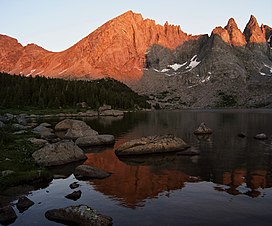
is significant as the west aspect rises 2,000 feet (610 meters) above Shadow Lake in one-half mile. Nearby geographic features include
1009:
479:
2446:
1136:
1025:
675:
637:
616:
515:
394:
2055:
246:
949:
361:
0.44 miles to the southeast. The peak's unofficial name commemorates Karl
Bollinger who perished August 11, 1953, from a
2461:
1519:
1002:
721:
422:
369:, the day after he climbed this namesake peak. His name has also been reported as Karl Bollinger Jr., and Kent Bollinger.
338:
2387:
2334:
452:
87:
989:
688:
Peel, M. C.; Finlayson, B. L.; McMahon, T. A. (2007). "Updated world map of the Köppen−Geiger climate classification".
2254:
2204:
1840:
657:
Accidents in
American Mountaineering: Annual Report of the Safety Committee of the American Alpine Club, 1954, page 7.
410:
2339:
2214:
1875:
1549:
1339:
2471:
2369:
2264:
2194:
2085:
1870:
1739:
1704:
1589:
878:
342:
298:
208:
2289:
2249:
1955:
1499:
1334:
1299:
1141:
471:
448:
382:
302:
285:
212:
2309:
2140:
1980:
1910:
1694:
1679:
1435:
1214:
1101:
1056:
64:
54:
2105:
2100:
2095:
1985:
1975:
1669:
1279:
924:"Injured man rescued from Square Top Mtn - Tip-Top Search & Rescue helps 2 injured on the mountain"
77:
923:
744:
2110:
2080:
2075:
2040:
2000:
1940:
1820:
1659:
1644:
1624:
1609:
1604:
1559:
1233:
1174:
1131:
1091:
1076:
775:
330:
326:
69:
895:
716:
2314:
2115:
1845:
1774:
1759:
1684:
1489:
1309:
1304:
1241:
831:
803:
499:
2120:
1865:
1850:
1529:
1349:
798:
487:
346:
334:
322:
261:
983:
2354:
2344:
2189:
2025:
1749:
1564:
1466:
1448:
1407:
1379:
1359:
1344:
1161:
697:
671:
633:
612:
495:
398:
2425:
2401:
2329:
2239:
2145:
2060:
1960:
1950:
1900:
1812:
1664:
1629:
1534:
1458:
1146:
1096:
1061:
900:
503:
491:
459:
436:
318:
230:
2150:
2130:
2005:
1965:
1789:
1689:
1579:
1504:
1415:
1364:
1257:
1194:
1179:
1126:
1051:
366:
241:
234:
771:"Falling Rock, Loose Rock, Failure to Test Holds, Wyoming, Wind River Range, Seneca Lake"
297:
is a 12,232-foot-elevation (3,728-meter) mountain summit located on the shared border of
2413:
2364:
2349:
2324:
2304:
2299:
2219:
2125:
2065:
2020:
2015:
1925:
1895:
1880:
1802:
1734:
1719:
1699:
1649:
1639:
1514:
1425:
1392:
1271:
1199:
1111:
1106:
1033:
475:
463:
426:
402:
223:
502:
does not offer updated aggregated records on the official number of fatalities in the
2435:
2284:
2279:
2229:
2165:
2135:
1995:
1935:
1920:
1825:
1764:
1674:
1544:
1484:
1294:
1209:
1041:
486:
in 2017. Other incidents include a seriously injured backpacker being airlifted near
362:
2408:
2374:
2359:
2259:
2234:
2224:
2173:
2090:
2050:
2035:
2010:
1970:
1915:
1890:
1860:
1835:
1744:
1634:
1594:
1584:
1574:
1509:
1494:
1420:
1329:
1324:
1319:
1284:
1204:
1169:
1121:
1116:
957:
483:
378:
358:
278:
854:
2294:
2269:
2244:
2199:
2070:
2030:
1945:
1855:
1779:
1769:
1754:
1729:
1724:
1714:
1709:
1619:
1599:
1554:
1476:
1387:
1369:
1314:
1289:
1224:
1189:
1151:
1086:
1066:
1046:
540:
432:
354:
2155:
1797:
1614:
1524:
1184:
1071:
745:"Wind River Range condition update - Fires, trails, bears, Continental Divide"
350:
701:
482:), 2015, and 2018. A 54-year-old climber fell 400–800 feet to his death from
109:
96:
2274:
2209:
2045:
1830:
28:
467:
1654:
444:
266:
409:
via
Washakie Creek, and the east side drains into Lonesome Lake, thence
1569:
994:
306:
216:
440:
44:
584:
478:, over the years, including 1993, 2007 (involving an experienced
998:
827:"Officials rule Wind River Range climbing deaths accidental"
345:. Bollinger ranks as the 148th-highest peak in Wyoming, and
458:
Importantly, there have been notable incidents, including
950:"Incident Reports - September, 2006 - Wind River Search"
881:
Climber Falls to His Death in
Wyoming's Wind River Range
490:
in 2005, and a fatal hiker incident (from an apparent
2385:
2182:
2164:
1811:
1788:
1475:
1457:
1434:
1406:
1378:
1270:
1250:
1232:
1223:
1160:
1032:
565:
Guide to the
Wyoming Mountains and Wilderness Areas
277:
272:
260:
255:
240:
222:
204:
125:
86:
76:
63:
53:
43:
38:
21:
377:The northeast ridge was first climbed in 1941 by
668:Climbing and Hiking in the Wind River Mountains
609:Climbing and Hiking in the Wind River Mountains
397:system, Bollinger Peak is located in an alpine
439:. There are other concerns as well, including
1010:
717:"Bear Safety in Wyoming's Wind River Country"
630:Sky's Witness: A Year In The Wind River Range
579:
577:
575:
573:
8:
405:from the mountain's west side drains to the
563:Orrin H. Bonney, Lorraine G. Bonney, 1965,
1229:
1017:
1003:
995:
18:
2392:
527:
33:West aspect, from Shadow Lake at sunset
797:MacDonald, Dougald (August 14, 2007).
178:
145:
2452:Mountains of Sublette County, Wyoming
7:
2457:Mountains of Fremont County, Wyoming
535:
533:
531:
329:. It is set on the common boundary
317:The peak is situated in the remote
1886:Dome Mountain (Hot Springs County)
896:"Squaretop Mountain Rock Climbing"
853:Dayton, Kelsey (August 24, 2018).
191:Bollinger Peak (the United States)
14:
799:"Trundled Rock Kills NOLS Leader"
516:List of mountain peaks of Wyoming
2419:
2407:
2395:
648:Chicago Tribune, August 14, 1953
632:, 2014, Henry Holt and Company,
177:
170:
144:
137:
27:
1906:Flagstone Peak (Fremont County)
353:, 0.16 mile to the south,
16:Mountain summit in Wyoming, USA
982:Bollinger Peak rock climbing:
883:, August 31, 2017, k2radio.com
743:Ballou, Dawn (July 27, 2005).
494:) in 2006 that involved state
357:one-half mile south, and
1:
2467:North American 3000 m summits
2442:Bridger–Teton National Forest
988:Bollinger's fatality report:
585:"Bollinger Peak - 12,232' WY"
427:Mountaineering § Hazards
423:Hazards of outdoor recreation
395:Köppen climate classification
339:Bridger-Teton National Forest
194:Show map of the United States
49:12,232 ft (3,728 m)
1444:Elk Mountain (Carbon County)
2320:Prospect Peak (Park County)
1841:Bastion Peak-Northeast Peak
1540:Elk Mountain (Teton County)
1300:Dome Mountain (Park County)
948:Staff (September 1, 2006).
453:nighttime cold temperatures
82:1.01 mi (1.63 km)
2488:
825:Staff (December 9, 2015).
420:
411:North Fork Popo Agie River
541:"Bollinger Peak, Wyoming"
130:
26:
2447:Shoshone National Forest
1705:Rolling Thunder Mountain
855:"Deadly underestimation"
715:Staff (April 24, 2017).
343:Shoshone National Forest
59:472 ft (144 m)
922:Staff (July 22, 2005).
690:Hydrol. Earth Syst. Sci
567:, Sage Books, page 181.
470:could be fatal in this
464:falls from steep cliffs
449:adverse snow conditions
2310:National Park Mountain
1436:Medicine Bow Mountains
1102:First Peoples Mountain
110:42.78278°N 109.23278°W
2096:Three Waters Mountain
2056:Roaring Fork Mountain
337:, on land managed by
2462:Mountains of Wyoming
2076:South Downs Mountain
1941:Knife Point Mountain
1821:American Legion Peak
1660:Prospectors Mountain
1645:Mount Woodrow Wilson
1610:Mount Jedediah Smith
1560:Green Lakes Mountain
1234:Bear Lodge Mountains
1175:Black Tooth Mountain
1026:Mountains of Wyoming
894:Funk, Jason (2009).
776:American Alpine Club
435:is a concern in the
331:Popo Agie Wilderness
327:Cirque of the Towers
115:42.78278; -109.23278
2315:Owl Creek Mountains
1846:Bears Ears Mountain
1685:Rendezvous Mountain
1520:Disappointment Peak
1490:Battleship Mountain
1242:Inyan Kara Mountain
984:Mountainproject.com
960:on January 27, 2020
928:PineDaleOnline News
832:Casper Star-Tribune
749:PineDaleOnline News
500:U.S. Forest Service
161:Show map of Wyoming
158:Location in Wyoming
106: /
2335:Sierra Madre Range
2121:Valentine Mountain
1866:Brown Cliffs North
1851:Big Sandy Mountain
1530:Dry Ridge Mountain
1350:Sepulcher Mountain
666:Joe Kelsey, 2013,
607:Joe Kelsey, 2013,
488:Squaretop Mountain
347:topographic relief
335:Bridger Wilderness
325:, in the renowned
323:Continental Divide
39:Highest point
2383:
2382:
2355:Sublette Mountain
2345:Snake River Range
2255:Granite Mountains
2205:Bridger Mountains
2190:Amethyst Mountain
2026:Overhanging Tower
1750:Teewinot Mountain
1565:Housetop Mountain
1467:Mount Fitzpatrick
1449:Medicine Bow Peak
1408:Laramie Mountains
1380:Gros Ventre Range
1360:Three Rivers Peak
1345:Quadrant Mountain
1266:
1265:
1162:Bighorn Mountains
1082:Fortress Mountain
954:WildernessDoc.com
670:, Falcon Guides,
611:, Falcon Guides,
496:search and rescue
472:class 4/5 terrain
460:accidental deaths
399:subarctic climate
393:According to the
309:, United States.
292:
291:
2479:
2424:
2423:
2422:
2412:
2411:
2400:
2399:
2398:
2391:
2330:Roaring Mountain
2240:Ferris Mountains
2146:Whiskey Mountain
2061:Roberts Mountain
1961:Mount Bonneville
1951:Lizard Head Peak
1901:East Temple Peak
1813:Wind River Range
1665:Rammell Mountain
1630:Mount Saint John
1535:Eagles Rest Peak
1459:Salt River Range
1355:Terrace Mountain
1230:
1147:Washakie Needles
1097:Mount Chittenden
1062:Clayton Mountain
1019:
1012:
1005:
996:
990:AAC-publications
970:
969:
967:
965:
956:. Archived from
945:
939:
938:
936:
934:
919:
913:
912:
910:
908:
901:Mountain Project
891:
885:
876:
870:
869:
867:
865:
850:
844:
843:
841:
839:
822:
816:
815:
813:
811:
794:
788:
787:
785:
783:
766:
760:
759:
757:
755:
740:
734:
733:
731:
729:
712:
706:
705:
685:
679:
664:
658:
655:
649:
646:
640:
626:
620:
605:
599:
598:
596:
595:
581:
568:
561:
555:
554:
552:
551:
537:
504:Wind River Range
437:Wind River Range
333:shares with the
319:Wind River Range
305:in the state of
281:
250:Lizard Head Peak
231:Wind River Range
226:
195:
181:
180:
174:
162:
148:
147:
141:
121:
120:
118:
117:
116:
111:
107:
104:
103:
102:
99:
31:
19:
2487:
2486:
2482:
2481:
2480:
2478:
2477:
2476:
2472:Rocky Mountains
2432:
2431:
2430:
2420:
2418:
2406:
2396:
2394:
2386:
2384:
2379:
2340:Signal Mountain
2215:Copper Mountain
2178:
2160:
2151:Wind River Peak
2131:War Bonnet Peak
2006:Mount Sacagawea
1966:Mount Chauvenet
1876:Desolation Peak
1807:
1790:Uinta Mountains
1784:
1690:Rendezvous Peak
1580:Maidenform Peak
1550:Fossil Mountain
1505:Cathedral Group
1471:
1453:
1430:
1416:Casper Mountain
1402:
1374:
1365:Trilobite Point
1340:Purple Mountain
1262:
1258:Missouri Buttes
1246:
1219:
1195:Hallelujah Peak
1180:Bomber Mountain
1156:
1127:Mount Stevenson
1052:Barronette Peak
1028:
1023:
979:
974:
973:
963:
961:
947:
946:
942:
932:
930:
921:
920:
916:
906:
904:
893:
892:
888:
877:
873:
863:
861:
852:
851:
847:
837:
835:
824:
823:
819:
809:
807:
796:
795:
791:
781:
779:
768:
767:
763:
753:
751:
742:
741:
737:
727:
725:
714:
713:
709:
687:
686:
682:
665:
661:
656:
652:
647:
643:
628:C. L. Rawlins,
627:
623:
606:
602:
593:
591:
589:listsofjohn.com
583:
582:
571:
562:
558:
549:
547:
539:
538:
529:
524:
512:
492:accidental fall
429:
421:Main articles:
419:
391:
375:
367:War Bonnet Peak
365:fall on nearby
315:
299:Sublette County
288:Northeast ridge
279:
235:Rocky Mountains
233:
224:
215:
209:Sublette County
200:
199:
198:
197:
196:
193:
192:
189:
188:
187:
186:
182:
165:
164:
163:
160:
159:
156:
155:
154:
153:
149:
114:
112:
108:
105:
100:
97:
95:
93:
92:
34:
17:
12:
11:
5:
2485:
2483:
2475:
2474:
2469:
2464:
2459:
2454:
2449:
2444:
2434:
2433:
2429:
2428:
2416:
2404:
2381:
2380:
2378:
2377:
2372:
2370:White Mountain
2367:
2365:Trischman Knob
2362:
2357:
2352:
2350:Specimen Ridge
2347:
2342:
2337:
2332:
2327:
2325:Rawhide Buttes
2322:
2317:
2312:
2307:
2305:Mount Washburn
2302:
2300:Mount Sheridan
2297:
2292:
2287:
2282:
2277:
2272:
2267:
2265:Heart Mountain
2262:
2257:
2252:
2247:
2242:
2237:
2232:
2227:
2222:
2220:Dirty Mountain
2217:
2212:
2207:
2202:
2197:
2195:Aspen Mountain
2192:
2186:
2184:
2180:
2179:
2177:
2176:
2170:
2168:
2162:
2161:
2159:
2158:
2153:
2148:
2143:
2138:
2133:
2128:
2126:Valentine Peak
2123:
2118:
2113:
2108:
2103:
2098:
2093:
2088:
2086:Split Mountain
2083:
2078:
2073:
2068:
2066:Shale Mountain
2063:
2058:
2053:
2048:
2043:
2038:
2033:
2028:
2023:
2021:Mount Whitecap
2018:
2016:Mount Washakie
2013:
2008:
2003:
1998:
1993:
1988:
1983:
1978:
1973:
1968:
1963:
1958:
1953:
1948:
1943:
1938:
1933:
1928:
1926:Henderson Peak
1923:
1918:
1913:
1908:
1903:
1898:
1896:Downs Mountain
1893:
1888:
1883:
1881:Dog Tooth Peak
1878:
1873:
1871:Cathedral Peak
1868:
1863:
1858:
1853:
1848:
1843:
1838:
1833:
1828:
1823:
1817:
1815:
1809:
1808:
1806:
1805:
1803:Medicine Butte
1800:
1794:
1792:
1786:
1785:
1783:
1782:
1777:
1772:
1767:
1762:
1757:
1752:
1747:
1742:
1740:Table Mountain
1737:
1735:Symmetry Spire
1732:
1727:
1722:
1720:Spearhead Peak
1717:
1712:
1707:
1702:
1700:Rockchuck Peak
1697:
1692:
1687:
1682:
1677:
1672:
1667:
1662:
1657:
1652:
1650:Nez Perce Peak
1647:
1642:
1640:Mount Woodring
1637:
1632:
1627:
1622:
1617:
1612:
1607:
1602:
1597:
1592:
1590:Moose Mountain
1587:
1582:
1577:
1572:
1567:
1562:
1557:
1552:
1547:
1542:
1537:
1532:
1527:
1522:
1517:
1515:Cloudveil Dome
1512:
1507:
1502:
1497:
1492:
1487:
1481:
1479:
1473:
1472:
1470:
1469:
1463:
1461:
1455:
1454:
1452:
1451:
1446:
1440:
1438:
1432:
1431:
1429:
1428:
1426:Muddy Mountain
1423:
1418:
1412:
1410:
1404:
1403:
1401:
1400:
1398:Sheep Mountain
1395:
1393:Doubletop Peak
1390:
1384:
1382:
1376:
1375:
1373:
1372:
1367:
1362:
1357:
1352:
1347:
1342:
1337:
1332:
1327:
1322:
1317:
1312:
1307:
1302:
1297:
1292:
1287:
1282:
1276:
1274:
1272:Gallatin Range
1268:
1267:
1264:
1263:
1261:
1260:
1254:
1252:
1248:
1247:
1245:
1244:
1238:
1236:
1227:
1221:
1220:
1218:
1217:
1212:
1207:
1202:
1200:The Innominate
1197:
1192:
1187:
1182:
1177:
1172:
1166:
1164:
1158:
1157:
1155:
1154:
1149:
1144:
1139:
1134:
1129:
1124:
1119:
1114:
1112:Mount Langford
1109:
1107:Mount Hornaday
1104:
1099:
1094:
1089:
1084:
1079:
1074:
1069:
1064:
1059:
1054:
1049:
1044:
1038:
1036:
1034:Absaroka Range
1030:
1029:
1024:
1022:
1021:
1014:
1007:
999:
993:
992:
986:
978:
977:External links
975:
972:
971:
940:
914:
886:
879:Nick Learned,
871:
845:
817:
789:
769:Staff (1993).
761:
735:
707:
680:
659:
650:
641:
621:
600:
569:
556:
545:Peakbagger.com
526:
525:
523:
520:
519:
518:
511:
508:
418:
415:
390:
387:
374:
371:
314:
311:
303:Fremont County
295:Bollinger Peak
290:
289:
283:
275:
274:
270:
269:
264:
258:
257:
253:
252:
244:
238:
237:
228:
220:
219:
213:Fremont County
206:
202:
201:
190:
185:Bollinger Peak
184:
183:
176:
175:
169:
168:
167:
166:
157:
152:Bollinger Peak
151:
150:
143:
142:
136:
135:
134:
133:
132:
131:
128:
127:
123:
122:
90:
84:
83:
80:
74:
73:
67:
61:
60:
57:
51:
50:
47:
41:
40:
36:
35:
32:
24:
23:
22:Bollinger Peak
15:
13:
10:
9:
6:
4:
3:
2:
2484:
2473:
2470:
2468:
2465:
2463:
2460:
2458:
2455:
2453:
2450:
2448:
2445:
2443:
2440:
2439:
2437:
2427:
2417:
2415:
2410:
2405:
2403:
2393:
2389:
2376:
2373:
2371:
2368:
2366:
2363:
2361:
2358:
2356:
2353:
2351:
2348:
2346:
2343:
2341:
2338:
2336:
2333:
2331:
2328:
2326:
2323:
2321:
2318:
2316:
2313:
2311:
2308:
2306:
2303:
2301:
2298:
2296:
2293:
2291:
2290:Mount Hancock
2288:
2286:
2285:Mansface Hill
2283:
2281:
2280:Jelm Mountain
2278:
2276:
2273:
2271:
2268:
2266:
2263:
2261:
2258:
2256:
2253:
2251:
2250:Garfield Peak
2248:
2246:
2243:
2241:
2238:
2236:
2233:
2231:
2230:Dunraven Peak
2228:
2226:
2223:
2221:
2218:
2216:
2213:
2211:
2208:
2206:
2203:
2201:
2198:
2196:
2193:
2191:
2188:
2187:
2185:
2181:
2175:
2172:
2171:
2169:
2167:
2166:Wyoming Range
2163:
2157:
2154:
2152:
2149:
2147:
2144:
2142:
2139:
2137:
2136:Warrior Peaks
2134:
2132:
2129:
2127:
2124:
2122:
2119:
2117:
2114:
2112:
2109:
2107:
2104:
2102:
2099:
2097:
2094:
2092:
2089:
2087:
2084:
2082:
2079:
2077:
2074:
2072:
2069:
2067:
2064:
2062:
2059:
2057:
2054:
2052:
2049:
2047:
2044:
2042:
2039:
2037:
2034:
2032:
2029:
2027:
2024:
2022:
2019:
2017:
2014:
2012:
2009:
2007:
2004:
2002:
1999:
1997:
1996:Mount Nystrom
1994:
1992:
1989:
1987:
1984:
1982:
1979:
1977:
1974:
1972:
1969:
1967:
1964:
1962:
1959:
1957:
1956:Mitchell Peak
1954:
1952:
1949:
1947:
1944:
1942:
1939:
1937:
1936:Klondike Peak
1934:
1932:
1929:
1927:
1924:
1922:
1921:Harrower Peak
1919:
1917:
1914:
1912:
1909:
1907:
1904:
1902:
1899:
1897:
1894:
1892:
1889:
1887:
1884:
1882:
1879:
1877:
1874:
1872:
1869:
1867:
1864:
1862:
1859:
1857:
1854:
1852:
1849:
1847:
1844:
1842:
1839:
1837:
1834:
1832:
1829:
1827:
1826:Atlantic Peak
1824:
1822:
1819:
1818:
1816:
1814:
1810:
1804:
1801:
1799:
1796:
1795:
1793:
1791:
1787:
1781:
1778:
1776:
1773:
1771:
1768:
1766:
1765:Traverse Peak
1763:
1761:
1758:
1756:
1753:
1751:
1748:
1746:
1743:
1741:
1738:
1736:
1733:
1731:
1728:
1726:
1723:
1721:
1718:
1716:
1713:
1711:
1708:
1706:
1703:
1701:
1698:
1696:
1693:
1691:
1688:
1686:
1683:
1681:
1678:
1676:
1675:Raynolds Peak
1673:
1671:
1668:
1666:
1663:
1661:
1658:
1656:
1653:
1651:
1648:
1646:
1643:
1641:
1638:
1636:
1633:
1631:
1628:
1626:
1623:
1621:
1618:
1616:
1613:
1611:
1608:
1606:
1603:
1601:
1598:
1596:
1593:
1591:
1588:
1586:
1583:
1581:
1578:
1576:
1573:
1571:
1568:
1566:
1563:
1561:
1558:
1556:
1553:
1551:
1548:
1546:
1545:Forellen Peak
1543:
1541:
1538:
1536:
1533:
1531:
1528:
1526:
1523:
1521:
1518:
1516:
1513:
1511:
1508:
1506:
1503:
1501:
1500:Buck Mountain
1498:
1496:
1493:
1491:
1488:
1486:
1485:Albright Peak
1483:
1482:
1480:
1478:
1474:
1468:
1465:
1464:
1462:
1460:
1456:
1450:
1447:
1445:
1442:
1441:
1439:
1437:
1433:
1427:
1424:
1422:
1419:
1417:
1414:
1413:
1411:
1409:
1405:
1399:
1396:
1394:
1391:
1389:
1386:
1385:
1383:
1381:
1377:
1371:
1368:
1366:
1363:
1361:
1358:
1356:
1353:
1351:
1348:
1346:
1343:
1341:
1338:
1336:
1335:Mount Jackson
1333:
1331:
1328:
1326:
1323:
1321:
1318:
1316:
1313:
1311:
1308:
1306:
1303:
1301:
1298:
1296:
1295:Clagett Butte
1293:
1291:
1288:
1286:
1283:
1281:
1278:
1277:
1275:
1273:
1269:
1259:
1256:
1255:
1253:
1249:
1243:
1240:
1239:
1237:
1235:
1231:
1228:
1226:
1222:
1216:
1213:
1211:
1210:Mount Woolsey
1208:
1206:
1203:
1201:
1198:
1196:
1193:
1191:
1188:
1186:
1183:
1181:
1178:
1176:
1173:
1171:
1168:
1167:
1165:
1163:
1159:
1153:
1150:
1148:
1145:
1143:
1142:The Thunderer
1140:
1138:
1135:
1133:
1130:
1128:
1125:
1123:
1120:
1118:
1115:
1113:
1110:
1108:
1105:
1103:
1100:
1098:
1095:
1093:
1090:
1088:
1085:
1083:
1080:
1078:
1075:
1073:
1070:
1068:
1065:
1063:
1060:
1058:
1055:
1053:
1050:
1048:
1045:
1043:
1042:Abiathar Peak
1040:
1039:
1037:
1035:
1031:
1027:
1020:
1015:
1013:
1008:
1006:
1001:
1000:
997:
991:
987:
985:
981:
980:
976:
959:
955:
951:
944:
941:
929:
925:
918:
915:
903:
902:
897:
890:
887:
884:
882:
875:
872:
860:
856:
849:
846:
834:
833:
828:
821:
818:
806:
805:
800:
793:
790:
778:
777:
772:
765:
762:
750:
746:
739:
736:
724:
723:
722:WindRiver.org
718:
711:
708:
703:
699:
695:
691:
684:
681:
677:
676:9781493001354
673:
669:
663:
660:
654:
651:
645:
642:
639:
638:9781466882416
635:
631:
625:
622:
618:
617:9781493001354
614:
610:
604:
601:
590:
586:
580:
578:
576:
574:
570:
566:
560:
557:
546:
542:
536:
534:
532:
528:
521:
517:
514:
513:
509:
507:
505:
501:
497:
493:
489:
485:
481:
477:
476:falling rocks
474:) and due to
473:
469:
465:
461:
456:
454:
450:
446:
442:
438:
434:
431:Encountering
428:
424:
416:
414:
412:
408:
404:
400:
396:
388:
386:
384:
380:
372:
370:
368:
364:
360:
356:
352:
348:
344:
340:
336:
332:
328:
324:
320:
312:
310:
308:
304:
300:
296:
287:
284:
282:
280:Easiest route
276:
271:
268:
265:
263:
259:
254:
251:
248:
245:
243:
239:
236:
232:
229:
227:
221:
218:
217:Wyoming, U.S.
214:
210:
207:
203:
173:
140:
129:
124:
119:
91:
89:
85:
81:
79:
75:
71:
68:
66:
62:
58:
56:
52:
48:
46:
42:
37:
30:
25:
20:
2375:Wilkins Peak
2360:Tongue Butte
2260:Granite Peak
2235:Factory Hill
2225:Douglas Knob
2174:Wyoming Peak
2091:Sunbeam Peak
2051:Rampart Peak
2036:Pingora Peak
2011:Mount Warren
1991:Mount Lander
1981:Mount Hooker
1971:Mount Febbas
1931:Jackson Peak
1916:Gannett Peak
1911:Fremont Peak
1891:Doublet Peak
1861:Bow Mountain
1836:Bastion Peak
1745:Teepe Pillar
1695:Rock of Ages
1680:Red Mountain
1635:Mount Wister
1595:Mount Bannon
1585:Middle Teton
1575:Littles Peak
1510:Cleaver Peak
1495:Bivouac Peak
1421:Laramie Peak
1330:Mount Holmes
1325:Mount Haynes
1320:Mount Everts
1285:Bannock Peak
1215:Penrose Peak
1205:Mather Peaks
1170:Bighorn Peak
1122:Mount Schurz
1117:Mount Norris
1057:Breccia Peak
964:February 17,
962:. Retrieved
958:the original
953:
943:
933:February 17,
931:. Retrieved
927:
917:
905:. Retrieved
899:
889:
880:
874:
864:February 15,
862:. Retrieved
859:WyoFile News
858:
848:
838:February 15,
836:. Retrieved
830:
820:
810:February 15,
808:. Retrieved
802:
792:
782:February 15,
780:. Retrieved
774:
764:
754:February 17,
752:. Retrieved
748:
738:
728:February 17,
726:. Retrieved
720:
710:
693:
689:
683:
667:
662:
653:
644:
629:
624:
608:
603:
592:. Retrieved
588:
564:
559:
548:. Retrieved
544:
484:Steeple Peak
457:
430:
392:
379:Norman Clyde
376:
359:Pingora Peak
316:
294:
293:
286:class 3
262:Type of rock
249:
225:Parent range
2295:Mount Leidy
2270:Hedges Peak
2245:Folsom Peak
2200:Barlow Peak
2141:Watch Tower
2106:Turret Peak
2101:Torrey Peak
2071:Sharks Nose
2031:Payson Peak
1986:Mount Koven
1976:Mount Helen
1946:Lander Peak
1856:Block Tower
1780:Window Peak
1770:Veiled Peak
1755:Temple Peak
1730:Survey Peak
1725:Static Peak
1715:South Teton
1710:Shadow Peak
1670:Ranger Peak
1620:Mount Moran
1600:Mount Glory
1555:Grand Teton
1477:Teton Range
1388:Darwin Peak
1370:White Peaks
1315:Joseph Peak
1290:Bunsen Peak
1280:Antler Peak
1225:Black Hills
1190:Darton Peak
1152:Younts Peak
1087:Francs Peak
1067:Colter Peak
1047:Atkins Peak
678:, page 428.
480:NOLS leader
407:Green River
355:Sharks Nose
313:Description
113: /
101:109°13′58″W
88:Coordinates
72:(12,383 ft)
65:Parent peak
2436:Categories
2156:Wolfs Head
2116:Union Peak
2111:Twin Peaks
2081:The Sphinx
2041:Pylon Peak
2001:Mount Owen
1798:Humpy Peak
1625:Mount Owen
1615:Mount Meek
1605:Mount Hunt
1525:Doane Peak
1185:Cloud Peak
1137:Sheep Mesa
1132:Pilot Peak
1092:Index Peak
1077:Eagle Peak
1072:Druid Peak
619:, page 30.
594:2021-07-31
550:2021-07-31
522:References
351:Wolfs Head
98:42°46′58″N
70:Pylon Peak
55:Prominence
2426:Mountains
2402:Geography
2275:Hoyt Peak
2210:Cook Peak
2046:Raid Peak
1831:Bair Peak
1760:Thor Peak
1310:Gray Peak
1305:Echo Peak
907:March 29,
702:1027-5606
462:, due to
445:wildfires
321:, on the
126:Geography
78:Isolation
45:Elevation
1775:The Wall
1655:Owl Peak
804:Climbing
510:See also
373:Climbing
273:Climbing
267:granitic
242:Topo map
205:Location
2414:Geology
2388:Portals
1570:The Jaw
468:misstep
417:Hazards
389:Climate
307:Wyoming
256:Geology
2183:Others
1251:Others
700:
674:
636:
615:
498:. The
403:runoff
363:leader
433:bears
966:2019
935:2019
909:2019
866:2019
840:2019
812:2019
784:2019
756:2019
730:2019
698:ISSN
672:ISBN
634:ISBN
613:ISBN
451:and
441:bugs
425:and
383:5.10
341:and
301:and
247:USGS
466:(a
385:).
2438::
952:.
926:.
898:.
857:.
829:.
801:.
773:.
747:.
719:.
696:.
694:11
692:.
587:.
572:^
543:.
530:^
506:.
455:.
447:,
443:,
413:.
211:/
2390::
1018:e
1011:t
1004:v
968:.
937:.
911:.
868:.
842:.
814:.
786:.
758:.
732:.
704:.
597:.
553:.
Text is available under the Creative Commons Attribution-ShareAlike License. Additional terms may apply.