55:
38:
83:
90:
62:
897:
54:
317:
648:. About halfway along the river's course, it widens out forming a small lake called Parr Lake. Beyond Parr Lake, the river narrows again and then nears
329:
159:
725:
341:
248:
82:
321:
125:
892:
600:
569:
534:
503:
472:
441:
406:
363:
173:
887:
656:. From Highway 165, the terrain begins to flatten out and the river empties into Lac la Ronge at Mosquito Point, just south of
562:). The Bow River itself begins at the west end of Ridge Lake and flows west where it is met by a short stream that flows from
669:
645:
396:
345:
337:
302:
20:
674:
653:
649:
400:
679:
644:
en route to Lac la Ronge. It is flanked on the east by
Meeyomoot River and on the west by Highway Creek and
637:
751:
391:) is the farthest upstream as it is east of Clarence-Steepbank Lakes Provincial Park and west of the
399:. At the west end of O'Conner Lake, a short stream flows out in a westerly direction, passing under
37:
356:
The Bow River chain lakes are a series of eight lakes in glacier-carved valleys that make up the
829:
803:
699:
657:
636:
From the chain lakes, Bow River turns northward following a glacier-carved valley through
563:
305:
296:
881:
435:
777:
357:
333:
325:
234:
130:
219:
615:
602:
584:
571:
549:
536:
518:
505:
487:
474:
456:
443:
421:
408:
378:
365:
263:
250:
188:
175:
855:
392:
403:, and into Clarence-Steepbank Lakes Provincial Park and then Hayes Lake (
652:
and runs parallel to it in a north-easterly direction until it crosses
641:
348:. There are no communities nor settlements along the river's course.
118:
328:. The river begins at Ridge Lake of Bow River chain lakes in
752:"Clarence-Steepbank Lakes Provincial Wilderness Park"
294:
289:
279:
240:
228:
218:
204:
165:
153:
145:
136:
124:
114:
109:
30:
89:
61:
898:Northern Saskatchewan Administration District
8:
726:"Clarence-Steepbank Lakes Provincial Park"
469:), which then flows downstream into Kit (
332:and flows in a northerly direction into
330:Clarence-Steepbank Lakes Provincial Park
160:Clarence-Steepbank Lakes Provincial Park
691:
27:
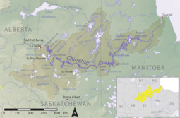
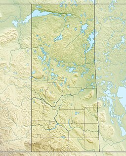
69:Location of the mouth in Saskatchewan
7:
834:Canadian Geographical Names Database
808:Canadian Geographical Names Database
704:Canadian Geographical Names Database
14:
360:of the Bow River. O'Conner Lake (
97:Bow River (Saskatchewan) (Canada)
318:Northern Administration District
88:
81:
60:
53:
36:
670:List of rivers of Saskatchewan
242: • coordinates
167: • coordinates
42:Churchill River drainage basin
1:
344:connects Lac la Ronge to the
137:Physical characteristics
16:River in Saskatchewan, Canada
732:. Government of Saskatchewan
397:Narrow Hills Provincial Park
338:Lac La Ronge Provincial Park
281: • elevation
206: • elevation
658:Potato River Indian Reserve
230: • location
155: • location
914:
434:). Hayes Lake connects to
285:360 m (1,180 ft)
210:540 m (1,770 ft)
18:
893:Tributaries of Hudson Bay
675:Hudson Bay drainage basin
214:
141:
47:
35:
72:Show map of Saskatchewan
680:Tourism in Saskatchewan
888:Rivers of Saskatchewan
836:. Government of Canada
810:. Government of Canada
784:. Virtual Saskatchewan
706:. Government of Canada
631:
352:Bow River chain lakes
149:Bow River chain lakes
782:Virtual Saskatchewan
730:Tourism Saskatchewan
616:54.2845°N 105.1726°W
585:54.2664°N 105.1096°W
550:54.2571°N 105.0463°W
531:), and Ridge Lakes (
519:54.2599°N 105.0328°W
488:54.2575°N 105.0185°W
457:54.2334°N 105.0004°W
422:54.2361°N 104.9926°W
379:54.2191°N 104.9341°W
264:54.9274°N 105.2134°W
189:54.2575°N 105.0513°W
19:For other uses, see
612: /
597:) and Birch Lakes (
581: /
546: /
515: /
484: /
453: /
418: /
375: /
290:Basin features
260: /
185: /
621:54.2845; -105.1726
590:54.2664; -105.1096
555:54.2571; -105.0463
524:54.2599; -105.0328
493:54.2575; -105.0185
462:54.2334; -105.0004
427:54.2361; -104.9926
384:54.2191; -104.9341
316:is a river in the
269:54.9274; -105.2134
194:54.2575; -105.0513
100:Show map of Canada
322:Canadian province
311:
310:
905:
872:
871:
869:
867:
852:
846:
845:
843:
841:
830:"Mosquito Point"
826:
820:
819:
817:
815:
800:
794:
793:
791:
789:
773:
767:
766:
764:
762:
748:
742:
741:
739:
737:
722:
716:
715:
713:
711:
696:
627:
626:
624:
623:
622:
617:
613:
610:
609:
608:
605:
596:
595:
593:
592:
591:
586:
582:
579:
578:
577:
574:
561:
560:
558:
557:
556:
551:
547:
544:
543:
542:
539:
530:
529:
527:
526:
525:
520:
516:
513:
512:
511:
508:
499:
498:
496:
495:
494:
489:
485:
482:
481:
480:
477:
468:
467:
465:
464:
463:
458:
454:
451:
450:
449:
446:
433:
432:
430:
429:
428:
423:
419:
416:
415:
414:
411:
390:
389:
387:
386:
385:
380:
376:
373:
372:
371:
368:
299:
275:
274:
272:
271:
270:
265:
261:
258:
257:
256:
253:
207:
200:
199:
197:
196:
195:
190:
186:
183:
182:
181:
178:
168:
156:
101:
92:
91:
85:
73:
64:
63:
57:
40:
28:
913:
912:
908:
907:
906:
904:
903:
902:
878:
877:
876:
875:
865:
863:
854:
853:
849:
839:
837:
828:
827:
823:
813:
811:
802:
801:
797:
787:
785:
775:
774:
770:
760:
758:
750:
749:
745:
735:
733:
724:
723:
719:
709:
707:
698:
697:
693:
688:
666:
634:
620:
618:
614:
611:
606:
603:
601:
599:
598:
589:
587:
583:
580:
575:
572:
570:
568:
567:
554:
552:
548:
545:
540:
537:
535:
533:
532:
523:
521:
517:
514:
509:
506:
504:
502:
501:
492:
490:
486:
483:
478:
475:
473:
471:
470:
461:
459:
455:
452:
447:
444:
442:
440:
439:
426:
424:
420:
417:
412:
409:
407:
405:
404:
383:
381:
377:
374:
369:
366:
364:
362:
361:
354:
346:Churchill River
303:Churchill River
295:
282:
268:
266:
262:
259:
254:
251:
249:
247:
246:
243:
231:
205:
193:
191:
187:
184:
179:
176:
174:
172:
171:
166:
154:
105:
104:
103:
102:
99:
98:
95:
94:
93:
76:
75:
74:
71:
70:
67:
66:
65:
43:
24:
17:
12:
11:
5:
911:
909:
901:
900:
895:
890:
880:
879:
874:
873:
847:
821:
795:
768:
743:
717:
690:
689:
687:
684:
683:
682:
677:
672:
665:
662:
646:Montreal River
633:
632:River's course
630:
353:
350:
309:
308:
306:drainage basin
300:
292:
291:
287:
286:
283:
280:
277:
276:
244:
241:
238:
237:
232:
229:
226:
225:
222:
216:
215:
212:
211:
208:
202:
201:
169:
163:
162:
157:
151:
150:
147:
143:
142:
139:
138:
134:
133:
128:
122:
121:
116:
112:
111:
107:
106:
96:
87:
86:
80:
79:
78:
77:
68:
59:
58:
52:
51:
50:
49:
48:
45:
44:
41:
33:
32:
15:
13:
10:
9:
6:
4:
3:
2:
910:
899:
896:
894:
891:
889:
886:
885:
883:
861:
857:
851:
848:
835:
831:
825:
822:
809:
805:
799:
796:
783:
779:
776:Yanko, Dave.
772:
769:
757:
753:
747:
744:
731:
727:
721:
718:
705:
701:
695:
692:
685:
681:
678:
676:
673:
671:
668:
667:
663:
661:
659:
655:
651:
647:
643:
639:
638:boreal forest
629:
625:
594:
565:
559:
528:
497:
466:
437:
436:Clarence Lake
431:
402:
398:
394:
388:
359:
351:
349:
347:
343:
339:
335:
331:
327:
323:
319:
315:
307:
304:
301:
298:
293:
288:
284:
278:
273:
245:
239:
236:
233:
227:
223:
221:
217:
213:
209:
203:
198:
170:
164:
161:
158:
152:
148:
144:
140:
135:
132:
129:
127:
123:
120:
117:
113:
108:
84:
56:
46:
39:
34:
29:
26:
22:
864:. Retrieved
859:
850:
838:. Retrieved
833:
824:
812:. Retrieved
807:
798:
786:. Retrieved
781:
778:"Wild Woods"
771:
759:. Retrieved
755:
746:
734:. Retrieved
729:
720:
708:. Retrieved
703:
694:
635:
355:
334:Lac la Ronge
326:Saskatchewan
313:
312:
297:River system
235:Lac la Ronge
131:Saskatchewan
25:
856:"Bow River"
804:"Parr Lake"
700:"Bow River"
654:Highway 165
650:Highway 969
619: /
607:105°10′21″W
588: /
576:105°06′35″W
553: /
541:105°02′47″W
522: /
510:105°01′58″W
500:), Jasper (
491: /
479:105°01′07″W
460: /
448:105°00′01″W
425: /
413:104°59′33″W
401:Highway 927
382: /
370:104°56′03″W
342:Rapid River
267: /
255:105°12′48″W
192: /
180:105°03′05″W
882:Categories
756:Sask Hiker
686:References
604:54°17′04″N
573:54°15′59″N
538:54°15′26″N
507:54°15′36″N
476:54°15′27″N
445:54°14′00″N
410:54°14′10″N
367:54°13′09″N
358:headwaters
252:54°55′39″N
177:54°15′27″N
866:12 August
862:. Geoview
840:12 August
814:12 August
788:10 August
761:12 August
736:12 August
710:12 August
564:Steepbank
393:Cub Hills
314:Bow River
31:Bow River
21:Bow River
664:See also
126:Province
110:Location
860:Geoview
320:of the
115:Country
642:muskeg
224:
146:Source
119:Canada
220:Mouth
868:2022
842:2022
816:2022
790:2022
763:2022
738:2022
712:2022
640:and
395:and
336:and
628:).
324:of
884::
858:.
832:.
806:.
780:.
754:.
728:.
702:.
660:.
340:.
870:.
844:.
818:.
792:.
765:.
740:.
714:.
566:(
438:(
23:.
Text is available under the Creative Commons Attribution-ShareAlike License. Additional terms may apply.