31:
185:
of
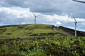
Scotland. It lends its name to Bowbeat Onshore Wind Farm built on the hill and commissioned in 2003. The wind farm produces 31.2MW of power using 24 turbines. It is commonly ascended with its neighbouring hills from Gladhouse Reservoir to the north.
283:
273:
278:
84:
77:
268:
244:
53:
208:
226:
63:
182:
150:
124:
162:
157:
178:
146:
139:
262:
69:
128:
99:
86:
132:
43:
30:
156:
138:
120:
115:
76:
62:
52:
42:
37:
23:
227:"Database of British and Irish Hills: user guide"
8:
284:Mountains and hills of the Southern Uplands
274:Mountains and hills of the Scottish Borders
20:
16:Hill in the Southern Uplands of Scotland
195:
203:
201:
199:
7:
14:
279:Mountains and hills of Midlothian
29:
1:
245:"Bowbeat onshore wind farm"
300:
48:626 m (2,054 ft)
28:
231:www.hills-database.co.uk
58:79 m (259 ft)
213:www.hill-bagging.co.uk
100:55.71056°N 3.12778°W
181:range, part of the
96: /
105:55.71056; -3.12778
38:Highest point
177:is a hill in the
172:
171:
291:
269:Donald mountains
253:
252:
241:
235:
234:
223:
217:
216:
205:
183:Southern Uplands
151:Southern Uplands
142:
125:Scottish Borders
111:
110:
108:
107:
106:
101:
97:
94:
93:
92:
89:
33:
21:
299:
298:
294:
293:
292:
290:
289:
288:
259:
258:
257:
256:
243:
242:
238:
225:
224:
220:
207:
206:
197:
192:
140:
104:
102:
98:
95:
90:
87:
85:
83:
82:
17:
12:
11:
5:
297:
295:
287:
286:
281:
276:
271:
261:
260:
255:
254:
236:
218:
209:"Bowbeat Hill"
194:
193:
191:
188:
179:Moorfoot Hills
170:
169:
160:
154:
153:
147:Moorfoot Hills
144:
136:
135:
122:
118:
117:
113:
112:
80:
74:
73:
66:
60:
59:
56:
50:
49:
46:
40:
39:
35:
34:
26:
25:
15:
13:
10:
9:
6:
4:
3:
2:
296:
285:
282:
280:
277:
275:
272:
270:
267:
266:
264:
250:
249:www.group.rwe
246:
240:
237:
232:
228:
222:
219:
214:
210:
204:
202:
200:
196:
189:
187:
184:
180:
176:
167:
164:
161:
159:
155:
152:
148:
145:
143:
137:
134:
130:
126:
123:
119:
114:
109:
81:
79:
75:
71:
67:
65:
61:
57:
55:
51:
47:
45:
41:
36:
32:
27:
22:
19:
248:
239:
230:
221:
212:
175:Bowbeat Hill
174:
173:
165:
141:Parent range
24:Bowbeat Hill
18:
103: /
78:Coordinates
263:Categories
190:References
166:Landranger
129:Midlothian
88:55°42′38″N
54:Prominence
116:Geography
91:3°07′40″W
44:Elevation
158:Topo map
133:Scotland
121:Location
68:Tu,Sim,
64:Listing
72:,GT,DN
265::
247:.
229:.
211:.
198:^
168:73
163:OS
149:,
131:,
127:,
251:.
233:.
215:.
70:D
Text is available under the Creative Commons Attribution-ShareAlike License. Additional terms may apply.