17:
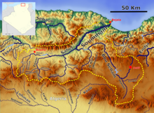
68:; It is formed of five streams, Wadi Mahouan, Wadi Mohammed el Hannach, oued Ouricia, Wadi Goussimet and Wadi Fermatou, which meet north of Setif. The river then takes the name Oued Bou Sellam; It runs first south-south-west, passes three kilometers west of Setif, and crosses the chain in which it takes its source between djebel Tafat and Guergour.
71:
The Oued Bou Sellam receives the wadi Malah, taking its source to Aïn Arnat in the dam Aïn Zada. After crossing the Aïn Zada dam, it crosses the Khelil commune by the east and receives two new tributaries,
91:. From the Guergour gorges, on the contrary, it flows in a very rugged country, arrives at the foot of the Guifsar, it turns abruptly to the west and flows into the wadi Sahel opposite the peak of Akbou.
270:
246:
194:
163:
275:
290:
239:
45:
280:
285:
232:
265:
128:
87:
Throughout this part of the course, the Bou Sellam watered the rich plain of Ameur, Ouled Mosli and
99:
The Oued Bou Sellam River contains 36% of the fish species of
Algerian inland waters (15 species).
65:
81:
73:
170:
77:
188:
88:
216:
60:
The basin of Bou Sellam is closed to the north, from the confluence of the river with the
259:
21:
49:
141:
61:
16:
64:, by Mount Gueldamane. Wadi Bou Sellam descends from the southern slopes of
48:. The river flows through the Bou Sellam Valley, and is obstructed by the
41:
37:
33:
15:
76:, which flows from the left bank in Besbassa halfway between
220:
215:This article related to a river in Algeria is a
240:
8:
247:
233:
271:Geography of Bordj Bou Arréridj Province
108:
193:: CS1 maint: archived copy as title (
186:
7:
212:
210:
219:. You can help Knowledge (XXG) by
84:shortly before on the right bank.
14:
24:basin with the Bou Sellam (right)
144:. Hidrotehnika-Hidroenergetika
80:and the Aïn Zada dam and the
1:
129:Defense Mapping Agency, 1981
117:The New International Atlas
46:Bordj Bou Arréridj Province
307:
276:Bodies of water of Algeria
209:
291:Algeria geography stubs
25:
19:
281:Landforms of Algeria
286:Africa river stubs
26:
266:Rivers of Algeria
228:
227:
298:
249:
242:
235:
211:
199:
198:
192:
184:
182:
181:
175:
169:. Archived from
168:
160:
154:
153:
151:
149:
138:
132:
126:
120:
113:
30:Bou Sellam River
306:
305:
301:
300:
299:
297:
296:
295:
256:
255:
254:
253:
207:
203:
202:
185:
179:
177:
173:
166:
164:"Archived copy"
162:
161:
157:
147:
145:
140:
139:
135:
127:
123:
114:
110:
105:
97:
58:
12:
11:
5:
304:
302:
294:
293:
288:
283:
278:
273:
268:
258:
257:
252:
251:
244:
237:
229:
226:
225:
201:
200:
155:
133:
121:
115:Rand McNally,
107:
106:
104:
101:
96:
93:
57:
54:
13:
10:
9:
6:
4:
3:
2:
303:
292:
289:
287:
284:
282:
279:
277:
274:
272:
269:
267:
264:
263:
261:
250:
245:
243:
238:
236:
231:
230:
224:
222:
218:
213:
208:
205:
196:
190:
176:on 2014-03-13
172:
165:
159:
156:
143:
137:
134:
130:
125:
122:
118:
112:
109:
102:
100:
94:
92:
90:
85:
83:
79:
75:
69:
67:
63:
55:
53:
51:
47:
43:
39:
35:
31:
23:
22:Soummam River
18:
221:expanding it
214:
206:
204:
178:. Retrieved
171:the original
158:
146:. Retrieved
136:
124:
116:
111:
98:
86:
70:
66:Mount Megris
59:
50:Ain Zada Dam
29:
27:
95:Environment
82:wadi Taissa
74:Wadi Khelil
56:Description
260:Categories
180:2017-06-22
142:"Ain Zada"
103:References
62:Oued Sahel
40:region in
148:22 August
78:El Kherba
189:cite web
89:Gherazla
119:, 1993.
42:Algeria
38:Maghreb
36:of the
174:(PDF)
167:(PDF)
44:, in
34:river
32:is a
217:stub
195:link
150:2011
28:The
20:The
262::
191:}}
187:{{
52:.
248:e
241:t
234:v
223:.
197:)
183:.
152:.
131:.
Text is available under the Creative Commons Attribution-ShareAlike License. Additional terms may apply.