17:
178:
110:
219:
253:
48:
212:
27:
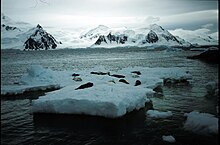
is an inlet, 30 miles (50 km) long in a northeast–southwest direction and 3 to 5 miles (5 to 8 km) wide, lying between the east sides of
243:
80:
British
Antarctic Territory. Scale 1:200000 topographic map. DOS 610 Series, Sheet W 67 66. Directorate of Overseas Surveys, Tolworth, UK, 1978.
139:
205:
124:
119:
129:
64:
238:
248:
114:
56:
52:
28:
185:
44:
90:
16:
189:
177:
32:
232:
40:
68:
60:
36:
154:
141:
63:. The outline of this inlet was more accurately delineated in 1936 by the
102:
15:
193:
47:to the south. The fjord was discovered by the
213:
8:
59:, Director of the Geographic Service of the
220:
206:
7:
174:
172:
49:French Antarctic Expedition, 1908–10
125:Geographic Names Information System
192:. You can help Knowledge (XXG) by
103:SCAR Composite Antarctic Gazetteer
20:Bourgeois Fjord seals on ice floe.
14:
176:
113: This article incorporates
108:
254:Fallières Coast geography stubs
130:United States Geological Survey
55:, and named by him for Colonel
244:Bodies of water of Graham Land
65:British Graham Land Expedition
1:
270:
171:
188:location article is a
115:public domain material
35:and the west coast of
21:
53:Jean-Baptiste Charcot
19:
239:Fjords of Antarctica
151: /
57:Joseph E. Bourgeois
29:Pourquoi Pas Island
43:to the north from
22:
201:
200:
155:67.667°S 67.083°W
120:"Bourgeois Fjord"
91:Lliboutry Glacier
261:
222:
215:
208:
180:
173:
166:
165:
163:
162:
161:
160:-67.667; -67.083
156:
152:
149:
148:
147:
144:
133:
112:
111:
33:Blaiklock Island
269:
268:
264:
263:
262:
260:
259:
258:
249:Fallières Coast
229:
228:
227:
226:
186:Fallières Coast
169:
159:
157:
153:
150:
145:
142:
140:
138:
137:
118:
109:
99:
87:
77:
45:Fallières Coast
39:. It separates
25:Bourgeois Fjord
12:
11:
5:
267:
265:
257:
256:
251:
246:
241:
231:
230:
225:
224:
217:
210:
202:
199:
198:
181:
135:
134:
106:
98:
95:
94:
93:
86:
83:
82:
81:
76:
73:
13:
10:
9:
6:
4:
3:
2:
266:
255:
252:
250:
247:
245:
242:
240:
237:
236:
234:
223:
218:
216:
211:
209:
204:
203:
197:
195:
191:
187:
182:
179:
175:
170:
167:
164:
131:
127:
126:
121:
116:
107:
104:
101:
100:
96:
92:
89:
88:
84:
79:
78:
74:
72:
70:
66:
62:
58:
54:
50:
46:
42:
38:
34:
30:
26:
18:
194:expanding it
183:
168:
136:
123:
41:Loubet Coast
24:
23:
158: /
69:John Rymill
61:French Army
37:Graham Land
233:Categories
97:References
85:See also
51:, under
143:67°40′S
146:67°5′W
67:under
184:This
117:from
190:stub
31:and
75:Map
235::
128:.
122:.
71:.
221:e
214:t
207:v
196:.
132:.
105:.
Text is available under the Creative Commons Attribution-ShareAlike License. Additional terms may apply.