169:
138:
40:
403:
285:
381:
176:
145:
263:(pronounced by locals as "Man-a-way"). From Mantua, US‑89/US‑91 enters Dry Canyon for 3 miles (4.8 km) before the combined routes reach their apex at Sardine Summit (5,981 feet ). From there, the highway enters a mountain valley known as Dry Lake before traversing Wellsville Canyon (popularly but incorrectly called "Sardine Canyon") before entering the
228:(US 89 / US 91) across the Wellsville Mountains. Both of these canyons are sometimes locally referred to as Sardine Canyon, although the actual Sardine Canyon is used by an old alignment of the highway along the eastern slope of the Wellsville Mountains.
252:
and US 91. The joint routes of US 89 / US 91 join together at 1100 South Main Street to the west and enter Box Elder Canyon 2 miles (3.2 km) east of downtown
Brigham City.
259:, a moderately-sized water impoundment created in 1961 through the construction of an earthen-fill dam at the upper mouth of the canyon, adjacent to the small farming community of
99:
385:
463:
168:
137:
468:
444:
300:
92:
255:
In addition to US 89 / US 91, Box Elder Canyon also contains Box Elder Creek, which flows westward from
318:
437:
213:
244:. The western or lower mouth of Box Elder Canyon is located approximately 56 miles (90 km) north of
236:
The valley was created by a prehistoric river, which flowed as a tributary into the main pool of ancient
360:
249:
225:
221:
49:
45:
39:
256:
201:
473:
62:
430:
241:
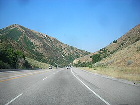
414:
331:
268:
75:
237:
209:
220:, United States. Box Elder Canyon and Wellsville Canyon together provide the routes of
245:
82:
457:
205:
264:
260:
53:
290:
17:
280:
114:
101:
319:
U.S. Geological Survey
Geographic Names Information System: Box Elder Canyon
402:
380:
410:
217:
153:
361:"Valleys in Box Elder County, UT - Utah State Valley List"
52:
heading down the canyon from the top (immediately west of
418:
200:
is a canyon located within the western slopes of the
91:
81:
71:
61:
32:
27:Canyon in Box Elder County, Utah, United States
438:
8:
330:Jones, Brittny Goodsell (October 11, 2008).
339:The Associated Press State & Local Wire
445:
431:
29:
386:Box Elder Canyon (Box Elder County, Utah)
332:"Sardine Canyon: The name's a bit fishy"
175:
144:
311:
7:
399:
397:
464:Landforms of Box Elder County, Utah
417:. You can help Knowledge (XXG) by
301:List of canyons and gorges in Utah
25:
44:Traveling southerly (west) along
401:
379:
283:
174:
167:
143:
136:
38:
240:, emerging east of present-day
1:
341:. Associated Press. p. 1
186:Show map of the United States
183:Location in the United States
490:
469:Canyons and gorges of Utah
396:
130:
37:
413:-related article is a
388:at Wikimedia Commons
202:Wellsville Mountains
115:41.4994°N 111.9944°W
111: /
204:, a branch of the
120:41.4994; -111.9944
67:5,525 ft (1,684 m)
426:
425:
384:Media related to
195:
194:
87:Wasatch Mountains
16:(Redirected from
481:
447:
440:
433:
405:
398:
383:
369:
368:
357:
351:
350:
348:
346:
336:
327:
321:
316:
293:
288:
287:
286:
257:Mantua Reservoir
214:Box Elder County
198:Box Elder Canyon
187:
178:
177:
171:
159:
158:Show map of Utah
147:
146:
140:
126:
125:
123:
122:
121:
116:
112:
109:
108:
107:
104:
76:Box Elder County
42:
33:Box Elder Canyon
30:
21:
18:Box Elder Canyon
489:
488:
484:
483:
482:
480:
479:
478:
454:
453:
452:
451:
394:
391:
377:
372:
359:
358:
354:
344:
342:
334:
329:
328:
324:
317:
313:
309:
297:
296:
289:
284:
282:
277:
238:Lake Bonneville
234:
210:Rocky Mountains
191:
190:
189:
188:
185:
184:
181:
180:
179:
162:
161:
160:
157:
156:
150:
149:
148:
119:
117:
113:
110:
105:
102:
100:
98:
97:
57:
28:
23:
22:
15:
12:
11:
5:
487:
485:
477:
476:
471:
466:
456:
455:
450:
449:
442:
435:
427:
424:
423:
406:
376:
375:External links
373:
371:
370:
352:
322:
310:
308:
305:
304:
303:
295:
294:
279:
278:
276:
273:
246:Salt Lake City
233:
230:
193:
192:
182:
173:
172:
166:
165:
164:
163:
151:
142:
141:
135:
134:
133:
132:
131:
128:
127:
95:
89:
88:
85:
79:
78:
73:
69:
68:
65:
59:
58:
43:
35:
34:
26:
24:
14:
13:
10:
9:
6:
4:
3:
2:
486:
475:
472:
470:
467:
465:
462:
461:
459:
448:
443:
441:
436:
434:
429:
428:
422:
420:
416:
412:
407:
404:
400:
395:
392:
389:
387:
382:
374:
366:
362:
356:
353:
340:
333:
326:
323:
320:
315:
312:
306:
302:
299:
298:
292:
281:
274:
272:
270:
266:
262:
258:
253:
251:
250:Interstate 15
247:
243:
239:
231:
229:
227:
226:U.S. Route 91
223:
222:U.S. Route 89
219:
215:
211:
207:
206:Wasatch Range
203:
199:
170:
155:
139:
129:
124:
96:
94:
90:
86:
84:
80:
77:
74:
70:
66:
64:
60:
55:
51:
47:
41:
36:
31:
19:
419:expanding it
408:
393:
390:
378:
364:
355:
345:November 21,
343:. Retrieved
338:
325:
314:
265:Cache Valley
254:
248:, Utah, via
242:Brigham City
235:
197:
196:
152:Location in
56:), July 2007
291:Utah portal
232:Description
118: /
106:111°59′40″W
93:Coordinates
474:Utah stubs
458:Categories
365:trails.com
307:References
269:Wellsville
103:41°29′58″N
50:US 91
46:US 89
63:Elevation
275:See also
72:Location
208:of the
261:Mantua
54:Mantua
409:This
335:(PDF)
83:Range
415:stub
411:Utah
347:2023
218:Utah
154:Utah
267:at
212:in
460::
363:.
337:.
271:.
224:/
216:,
48:/
446:e
439:t
432:v
421:.
367:.
349:.
20:)
Text is available under the Creative Commons Attribution-ShareAlike License. Additional terms may apply.