425:
601:
471:
1259:
98:
1551:
1336:
82:
397:
105:
651:). In 2017, the school had an enrolment of 361 students with 25 teachers (21 full-time equivalent) and 20 non-teaching staff (13 full-time equivalent). In 2018, the school had an enrolment of 384 students with 25 teachers (23 full-time equivalent) and 21 non-teaching staff (13 full-time equivalent). It includes a
1246:
Three football codes are represented. Boyne Tannum
Football Club also known as the Sharks (established 1979) play in the local soccer competition. Boyne Island-Tannum Sands AFC also known as BITS Saints (established 1984), based at Boyne Island Oval, are the most successful club in the
439:
St Luke's
Anglican Church was built in 1924 on Sayre Crescent. It was designed by Arthur Malpass. It was built from timber. Although the 1924 church building still stands, it was replaced in 1995 by a new brick church building called St Mark's adjacent to the old church building.
1274:
Boyne Island is home to the Boyne Tannum Hookup, which is a large fishing event held on the Labour Day long weekend in May each year. The event is held at Bray Park, which is on the river near the skate park. This event is very popular, with more than 3,000 entrants.
412:, an island in a river or an estuary. It is bounded on the eastern side by the Boyne River, for about 4 kilometres (2.5 mi) and the South Trees Inlet, on the southern, for 9 kilometres (5.6 mi), and western sides, for about 8 kilometres (5.0 mi)
1712:
539:
661:
1913:
492:
813:
723:
1200:
942:
130:
1828:
1660:
1738:
1028:
770:
614:
424:
1993:
1071:
600:
1157:
1114:
985:
899:
277:
265:
856:
1742:
1708:
1380:
698:). It offers hands-on activities for students to learn about natural coastal, marine and reef environments of the area and to understand human use of these areas.
1351:
1939:
1901:
2063:
533:
2529:
2413:
97:
1820:
1652:
2108:
2524:
2495:
253:
416:
is located on the eastern side of the mouth of the Boyne River spreading southward and is often referred to as Boyne Island's twin town.
470:
1482:
1448:
366:
2539:
2519:
1858:
1734:
405:
1529:
1314:
1252:
436:
in 1823. Originally the island was used for sheep grazing, this was followed by small crops, horticulture, fishing and timber.
270:
1258:
2056:
702:
586:
486:
23:
1504:
1417:
2388:
2268:
2514:
1624:
1568:
604:
123:
2478:
2393:
336:
1969:
592:
Australia's largest aluminium smelter, Boyne
Smelters Ltd., is located north of the town separated by a buffer zone.
2041:
2463:
714:
658:
Boyne Island
Environmental Education Centre is an Outdoor and Environmental Education Centre at 61 Malpas Street (
2534:
2298:
2238:
2203:
2188:
2049:
2453:
2418:
2353:
2338:
2318:
2148:
2113:
2103:
1999:
1935:
1772:
413:
232:
50:
2348:
1686:
319:
45:
2443:
2398:
2383:
2363:
2343:
2323:
2208:
2088:
2036:
305:
300:
1794:
611:
Boyne Island State School is a government primary (Prep-6) school for boys and girls at 151 Malpas Street (
2468:
2408:
2378:
2313:
2303:
2243:
1533:
1318:
459:
452:
378:
191:
175:
1619:
1563:
40:
2473:
2368:
2328:
2273:
2258:
2233:
2213:
2198:
2158:
2153:
2133:
1909:
1656:
1508:
1388:
1359:
385:
1266:
The 13-hole Boyne Island Tannum Sands Golf Course is adjacent to the Boyne River, in
Jacaranda Drive.
2403:
2373:
2333:
2288:
2283:
2253:
2248:
2228:
2223:
2183:
2118:
2433:
2293:
2278:
2193:
2173:
2163:
2123:
2098:
1598:
2483:
2438:
2358:
2218:
2093:
2263:
652:
282:
209:
2073:
1251:
competition. Tannum Sands
Seagulls (established 1994), based at Dennis Park, compete in the
370:
258:
1474:
1440:
81:
1248:
479:
1550:
1335:
701:
There is no secondary school in Boyne Island. The nearest government secondary school is
396:
35:
717:
operates a public library on Boyne Island at the corner of
Wyndham & Hayes Avenue.
1850:
2508:
1288:
1284:
409:
238:
346:
341:
2308:
2178:
1409:
720:
St Mark's
Anglican Church is on the corner of Malpas Stand and Sayre Crescent (
2077:
2025:
433:
374:
218:
72:
1216:
1202:
1173:
1159:
1130:
1116:
1087:
1073:
1044:
1030:
1001:
987:
958:
944:
915:
901:
872:
858:
829:
815:
786:
772:
739:
725:
677:
663:
630:
616:
555:
541:
508:
494:
146:
132:
2428:
2423:
428:
St Mark's
Anglican Church (left) and St Luke's Anglican Church (right), 1992
328:
311:
1594:
1961:
2128:
244:
489:, Wyndham Park Heritage Site, accessed between 36 and 38 Alkina Street (
2448:
2138:
1564:"William Wyndhams gravesite and remnant orchard trees (entry 601811)"
2032:. Centre for the Government of Queensland, University of Queensland.
1798:
1764:
585:
Today Boyne Island is primarily a residential centre for the nearby
1682:
2458:
2168:
1257:
607:
Year 4 students at the Boyne Island
Environmental Education Centre
599:
469:
423:
395:
462:, the locality of Boyne Island had a population of 4,835 people.
455:, the locality of Boyne Island had a population of 4,760 people.
381:, the locality of Boyne Island had a population of 4,835 people.
214:
2045:
1381:"Boyne Island – locality in Gladstone Region (entry 49334)"
432:
The town was named for the Boyne River, which was named by
1739:
Australian Curriculum, Assessment and Reporting Authority
763:
There are a number of parks in the locality, including:
1352:"Boyne Island – town in Gladstone Region (entry 4230)"
1765:"Boyne Island Environmental Education Centre (BIEEC)"
443:
Boyne Island State School opened on 27 January 1953.
1896:
384:
Boyne Island is 25 kilometres (16 mi) south of
1894:
1892:
1890:
1888:
1886:
1884:
1882:
1880:
1878:
1876:
276:
264:
252:
225:
208:
200:
190:
182:
170:
122:
66:
1992:
1647:
1645:
1643:
1505:"Opening and closing dates of Queensland Schools"
1262:Entrance to Boyne Island Tannum Sands Golf Course
1994:"CQ-born BMX rider's historic Olympic selection"
705:in neighbouring Tannum Sands to the south-east.
289:
2057:
1795:"Boyne Island Environmental Education Centre"
408:and, is a particular type of island called a
8:
1468:
1466:
1309:
1307:
1305:
1769:Boyne Island Environmental Education Centre
689:Boyne Island Environmental Education Centre
2064:
2050:
2042:
1620:"St Luke's Anglican Church (entry 600385)"
1549:
1410:"Map of Boyne Island, QLD 4680 | Whereis®"
1334:
80:
63:
1902:"Land for public recreation – Queensland"
1936:"Boyne Island-Tannum Sands Country Club"
1589:
1587:
1301:
1346:
1344:
404:It is located on the west bank of the
2072:Towns, suburbs and localities in the
1942:from the original on 12 November 2014
1916:from the original on 22 November 2020
1861:from the original on 28 February 2023
1715:from the original on 22 November 2018
1689:from the original on 23 February 2021
1663:from the original on 21 November 2018
334:
317:
298:
291:
7:
2496:Local government areas of Queensland
1972:from the original on 7 December 2017
1831:from the original on 24 January 2018
1653:"State and non-state school details"
1485:from the original on 2 November 2022
1479:Queensland religious places database
1451:from the original on 9 November 2022
1445:Queensland religious places database
1420:from the original on 7 December 2017
104:
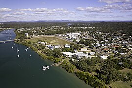
86:Boyne Island from the air - May 2023
1745:from the original on 27 August 2020
204:49.4 km (19.1 sq mi)
567:St Luke's Anglican Church (former)
14:
1775:from the original on 4 March 2021
474:William Wyndham's gravesite, 2004
243:498 km (309 mi) NNW of
2530:Fishing communities in Australia
1991:Berlin, Lachlan (18 June 2021).
810:Boyne Island Conservation Park (
237:24.0 km (15 mi) SE of
103:
96:
1962:"About the Boyne Tannum Hookup"
1827:. State Library of Queensland.
1530:Australian Bureau of Statistics
1315:Australian Bureau of Statistics
1253:Gladstone District Rugby League
294:Localities around Boyne Island:
841:Boyne Island Conservation Park
703:Tannum Sands State High School
587:Boyne Island aluminium smelter
400:Mouth of the Boyne River, 2008
1:
1628:. Queensland Heritage Council
1572:. Queensland Heritage Council
478:Boyne Island has a number of
231:2.1 km (1 mi) W of
61:Town in Queensland, Australia
1625:Queensland Heritage Register
1569:Queensland Heritage Register
1197:Wyndham Park Heritage Site (
939:Dennis Park Sports Complex (
186:97.87/km (253.49/sq mi)
2525:Coastal towns in Queensland
1735:"ACARA School Profile 2018"
1709:"ACARA School Profile 2017"
1683:"Boyne Island State School"
1475:"St Luke's Anglican Church"
1441:"St Luke's Anglican Church"
520:William Wyndahm's gravesite
487:William Wyndham's gravesite
51:GPX (secondary coordinates)
2556:
1228:Wyndham Park Heritage Site
970:Dennis Park Sports Complex
715:Gladstone Regional Council
589:and Gladstone industries.
158:Boyne Island (town centre)
2492:
2084:
751:St Mark's Anglican Church
642:Boyne Island State School
534:St Luke's Anglican Church
352:
292:
288:
91:
79:
46:GPX (primary coordinates)
21:Map all coordinates using
2540:Localities in Queensland
2520:Boyne Island, Queensland
1966:boynetannumhookup.com.au
1825:Public Libraries Connect
29:Download coordinates as:
605:Moore Park State School
1821:"Boyne Island Library"
1538:2016 Census QuickStats
1385:Queensland Place Names
1356:Queensland Place Names
1323:2021 Census QuickStats
1263:
1025:Jacaranda Drive Park (
767:Bauhinia Street Park (
608:
475:
429:
401:
365:is a coastal town and
1910:Queensland Government
1657:Queensland Government
1509:Queensland Government
1389:Queensland Government
1360:Queensland Government
1261:
740:23.955757°S 151.351°E
603:
473:
427:
399:
41:GPX (all coordinates)
1912:. 20 November 2020.
1906:Queensland Open Data
1534:"Boyne Island (SSC)"
1319:"Boyne Island (SAL)"
1217:23.9344°S 151.3528°E
1174:23.9512°S 151.3560°E
1131:23.9517°S 151.3576°E
1088:23.9541°S 151.3505°E
1056:Jacaranda Drive Park
1045:23.9653°S 151.3414°E
1002:23.9461°S 151.3512°E
959:23.9631°S 151.3336°E
916:23.9560°S 151.3553°E
873:23.9419°S 151.3533°E
830:23.9500°S 151.3475°E
798:Bauhinia Street Park
787:23.9548°S 151.3449°E
678:23.9573°S 151.3502°E
631:23.9501°S 151.3564°E
509:23.9344°S 151.3528°E
377:, Australia. In the
147:23.9477°S 151.3550°E
2515:Towns in Queensland
1771:. 21 October 2020.
1599:State of Queensland
1212: /
1169: /
1126: /
1083: /
1040: /
997: /
954: /
911: /
868: /
825: /
782: /
745:-23.955757; 151.351
735: /
673: /
626: /
556:23.9557°S 151.351°E
551: /
504: /
278:Federal division(s)
266:State electorate(s)
142: /
1595:"Queensland Globe"
1264:
1222:-23.9344; 151.3528
1179:-23.9512; 151.3560
1136:-23.9517; 151.3576
1093:-23.9541; 151.3505
1050:-23.9653; 151.3414
1007:-23.9461; 151.3512
964:-23.9631; 151.3336
921:-23.9560; 151.3553
878:-23.9419; 151.3533
835:-23.9500; 151.3475
792:-23.9548; 151.3449
683:-23.9573; 151.3502
636:-23.9501; 151.3564
609:
536:, Sayre Crescent (
514:-23.9344; 151.3528
482:sites, including:
476:
430:
402:
152:-23.9477; 151.3550
2502:
2501:
2389:Seventeen Seventy
2269:Gladstone Harbour
2264:Gladstone Central
2037:Community website
2030:Queensland Places
653:special education
561:-23.9557; 151.351
466:Heritage listings
360:
359:
356:
355:
2547:
2535:Gladstone Region
2074:Gladstone Region
2066:
2059:
2052:
2043:
2033:
2012:
2011:
2009:
2007:
1996:
1988:
1982:
1981:
1979:
1977:
1958:
1952:
1951:
1949:
1947:
1932:
1926:
1925:
1923:
1921:
1898:
1871:
1870:
1868:
1866:
1847:
1841:
1840:
1838:
1836:
1817:
1811:
1810:
1808:
1806:
1801:on 20 March 2012
1797:. Archived from
1791:
1785:
1784:
1782:
1780:
1761:
1755:
1754:
1752:
1750:
1731:
1725:
1724:
1722:
1720:
1705:
1699:
1698:
1696:
1694:
1679:
1673:
1672:
1670:
1668:
1649:
1638:
1637:
1635:
1633:
1616:
1610:
1609:
1607:
1605:
1591:
1582:
1581:
1579:
1577:
1560:
1554:
1553:
1548:
1546:
1544:
1532:(27 June 2017).
1526:
1520:
1519:
1517:
1515:
1501:
1495:
1494:
1492:
1490:
1470:
1461:
1460:
1458:
1456:
1436:
1430:
1429:
1427:
1425:
1406:
1400:
1399:
1397:
1395:
1377:
1371:
1370:
1368:
1366:
1348:
1339:
1338:
1333:
1331:
1329:
1317:(28 June 2022).
1311:
1236:
1235:
1233:
1232:
1231:
1229:
1224:
1223:
1218:
1213:
1210:
1209:
1208:
1205:
1193:
1192:
1190:
1189:
1188:
1186:
1181:
1180:
1175:
1170:
1167:
1166:
1165:
1162:
1150:
1149:
1147:
1146:
1145:
1143:
1138:
1137:
1132:
1127:
1124:
1123:
1122:
1119:
1107:
1106:
1104:
1103:
1102:
1100:
1095:
1094:
1089:
1084:
1081:
1080:
1079:
1076:
1064:
1063:
1061:
1060:
1059:
1057:
1052:
1051:
1046:
1041:
1038:
1037:
1036:
1033:
1021:
1020:
1018:
1017:
1016:
1014:
1009:
1008:
1003:
998:
995:
994:
993:
990:
978:
977:
975:
974:
973:
971:
966:
965:
960:
955:
952:
951:
950:
947:
935:
934:
932:
931:
930:
928:
923:
922:
917:
912:
909:
908:
907:
904:
892:
891:
889:
888:
887:
885:
880:
879:
874:
869:
866:
865:
864:
861:
849:
848:
846:
845:
844:
842:
837:
836:
831:
826:
823:
822:
821:
818:
806:
805:
803:
802:
801:
799:
794:
793:
788:
783:
780:
779:
778:
775:
759:
758:
756:
755:
754:
752:
747:
746:
741:
736:
733:
732:
731:
728:
697:
696:
694:
693:
692:
690:
685:
684:
679:
674:
671:
670:
669:
666:
650:
649:
647:
646:
645:
643:
638:
637:
632:
627:
624:
623:
622:
619:
575:
574:
572:
571:
570:
568:
563:
562:
557:
552:
549:
548:
547:
544:
528:
527:
525:
524:
523:
521:
516:
515:
510:
505:
502:
501:
500:
497:
371:Gladstone Region
290:
259:Gladstone Region
166:
165:
163:
162:
161:
159:
154:
153:
148:
143:
140:
139:
138:
135:
107:
106:
100:
84:
75:
69:
64:
2555:
2554:
2550:
2549:
2548:
2546:
2545:
2544:
2505:
2504:
2503:
2498:
2488:
2479:Wurdong Heights
2394:South Gladstone
2080:
2070:
2024:
2021:
2016:
2015:
2005:
2003:
1990:
1989:
1985:
1975:
1973:
1960:
1959:
1955:
1945:
1943:
1934:
1933:
1929:
1919:
1917:
1900:
1899:
1874:
1864:
1862:
1849:
1848:
1844:
1834:
1832:
1819:
1818:
1814:
1804:
1802:
1793:
1792:
1788:
1778:
1776:
1763:
1762:
1758:
1748:
1746:
1733:
1732:
1728:
1718:
1716:
1707:
1706:
1702:
1692:
1690:
1681:
1680:
1676:
1666:
1664:
1659:. 9 July 2018.
1651:
1650:
1641:
1631:
1629:
1618:
1617:
1613:
1603:
1601:
1593:
1592:
1585:
1575:
1573:
1562:
1561:
1557:
1542:
1540:
1528:
1527:
1523:
1513:
1511:
1503:
1502:
1498:
1488:
1486:
1472:
1471:
1464:
1454:
1452:
1438:
1437:
1433:
1423:
1421:
1408:
1407:
1403:
1393:
1391:
1379:
1378:
1374:
1364:
1362:
1350:
1349:
1342:
1327:
1325:
1313:
1312:
1303:
1298:
1281:
1272:
1249:AFL Capricornia
1244:
1227:
1225:
1221:
1219:
1215:
1214:
1211:
1206:
1203:
1201:
1199:
1198:
1184:
1182:
1178:
1176:
1172:
1171:
1168:
1163:
1160:
1158:
1156:
1155:
1141:
1139:
1135:
1133:
1129:
1128:
1125:
1120:
1117:
1115:
1113:
1112:
1098:
1096:
1092:
1090:
1086:
1085:
1082:
1077:
1074:
1072:
1070:
1069:
1055:
1053:
1049:
1047:
1043:
1042:
1039:
1034:
1031:
1029:
1027:
1026:
1012:
1010:
1006:
1004:
1000:
999:
996:
991:
988:
986:
984:
983:
969:
967:
963:
961:
957:
956:
953:
948:
945:
943:
941:
940:
926:
924:
920:
918:
914:
913:
910:
905:
902:
900:
898:
897:
883:
881:
877:
875:
871:
870:
867:
862:
859:
857:
855:
854:
840:
838:
834:
832:
828:
827:
824:
819:
816:
814:
812:
811:
797:
795:
791:
789:
785:
784:
781:
776:
773:
771:
769:
768:
750:
748:
744:
742:
738:
737:
734:
729:
726:
724:
722:
721:
711:
688:
686:
682:
680:
676:
675:
672:
667:
664:
662:
660:
659:
641:
639:
635:
633:
629:
628:
625:
620:
617:
615:
613:
612:
598:
583:
566:
564:
560:
558:
554:
553:
550:
545:
542:
540:
538:
537:
519:
517:
513:
511:
507:
506:
503:
498:
495:
493:
491:
490:
480:heritage-listed
468:
449:
422:
394:
337:Wurdong Heights
183: • Density
157:
155:
151:
149:
145:
144:
141:
136:
133:
131:
129:
128:
118:
117:
116:
115:
114:
113:
112:
108:
87:
71:
70:
67:
62:
59:
58:
57:
56:
55:
12:
11:
5:
2553:
2551:
2543:
2542:
2537:
2532:
2527:
2522:
2517:
2507:
2506:
2500:
2499:
2494:Main Article:
2493:
2490:
2489:
2487:
2486:
2481:
2476:
2471:
2466:
2464:West Gladstone
2461:
2456:
2451:
2446:
2441:
2436:
2431:
2426:
2421:
2416:
2411:
2406:
2401:
2396:
2391:
2386:
2381:
2376:
2371:
2366:
2361:
2356:
2351:
2346:
2341:
2336:
2331:
2326:
2321:
2316:
2311:
2306:
2301:
2296:
2291:
2286:
2281:
2276:
2271:
2266:
2261:
2256:
2251:
2246:
2241:
2236:
2231:
2226:
2221:
2216:
2211:
2206:
2201:
2196:
2191:
2186:
2181:
2176:
2171:
2166:
2161:
2156:
2151:
2146:
2141:
2136:
2131:
2126:
2121:
2116:
2111:
2106:
2101:
2096:
2091:
2085:
2082:
2081:
2071:
2069:
2068:
2061:
2054:
2046:
2040:
2039:
2034:
2026:"Boyne Island"
2020:
2019:External links
2017:
2014:
2013:
1983:
1953:
1927:
1872:
1842:
1812:
1786:
1756:
1726:
1700:
1674:
1639:
1611:
1583:
1555:
1521:
1496:
1462:
1431:
1401:
1372:
1340:
1300:
1299:
1297:
1294:
1293:
1292:
1280:
1279:Notable people
1277:
1271:
1268:
1243:
1240:
1239:
1238:
1195:
1152:
1109:
1068:Kirrang Park (
1066:
1023:
980:
937:
894:
851:
808:
710:
707:
597:
594:
582:
579:
578:
577:
530:
467:
464:
448:
445:
421:
418:
393:
390:
358:
357:
354:
353:
350:
349:
344:
339:
333:
332:
325:
322:
316:
315:
308:
303:
297:
296:
286:
285:
280:
274:
273:
268:
262:
261:
256:
250:
249:
248:
247:
241:
235:
227:
223:
222:
212:
206:
205:
202:
198:
197:
194:
188:
187:
184:
180:
179:
172:
168:
167:
126:
120:
119:
110:
109:
102:
101:
95:
94:
93:
92:
89:
88:
85:
77:
76:
60:
54:
53:
48:
43:
38:
32:
26:
19:
18:
17:
13:
10:
9:
6:
4:
3:
2:
2552:
2541:
2538:
2536:
2533:
2531:
2528:
2526:
2523:
2521:
2518:
2516:
2513:
2512:
2510:
2497:
2491:
2485:
2482:
2480:
2477:
2475:
2472:
2470:
2467:
2465:
2462:
2460:
2457:
2455:
2452:
2450:
2447:
2445:
2442:
2440:
2437:
2435:
2432:
2430:
2427:
2425:
2422:
2420:
2417:
2415:
2412:
2410:
2407:
2405:
2402:
2400:
2397:
2395:
2392:
2390:
2387:
2385:
2382:
2380:
2377:
2375:
2372:
2370:
2367:
2365:
2362:
2360:
2357:
2355:
2352:
2350:
2347:
2345:
2342:
2340:
2337:
2335:
2332:
2330:
2327:
2325:
2322:
2320:
2317:
2315:
2312:
2310:
2307:
2305:
2302:
2300:
2299:Machine Creek
2297:
2295:
2292:
2290:
2287:
2285:
2282:
2280:
2277:
2275:
2272:
2270:
2267:
2265:
2262:
2260:
2257:
2255:
2252:
2250:
2247:
2245:
2242:
2240:
2239:Farmers Point
2237:
2235:
2232:
2230:
2227:
2225:
2222:
2220:
2217:
2215:
2212:
2210:
2207:
2205:
2204:Curtis Island
2202:
2200:
2197:
2195:
2192:
2190:
2189:Captain Creek
2187:
2185:
2182:
2180:
2177:
2175:
2172:
2170:
2167:
2165:
2162:
2160:
2157:
2155:
2152:
2150:
2147:
2145:
2142:
2140:
2137:
2135:
2132:
2130:
2127:
2125:
2122:
2120:
2117:
2115:
2112:
2110:
2107:
2105:
2102:
2100:
2097:
2095:
2092:
2090:
2087:
2086:
2083:
2079:
2075:
2067:
2062:
2060:
2055:
2053:
2048:
2047:
2044:
2038:
2035:
2031:
2027:
2023:
2022:
2018:
2002:
2001:
1995:
1987:
1984:
1971:
1967:
1963:
1957:
1954:
1941:
1937:
1931:
1928:
1915:
1911:
1907:
1903:
1897:
1895:
1893:
1891:
1889:
1887:
1885:
1883:
1881:
1879:
1877:
1873:
1860:
1856:
1852:
1846:
1843:
1830:
1826:
1822:
1816:
1813:
1800:
1796:
1790:
1787:
1774:
1770:
1766:
1760:
1757:
1744:
1740:
1736:
1730:
1727:
1714:
1710:
1704:
1701:
1688:
1684:
1678:
1675:
1662:
1658:
1654:
1648:
1646:
1644:
1640:
1627:
1626:
1621:
1615:
1612:
1600:
1596:
1590:
1588:
1584:
1571:
1570:
1565:
1559:
1556:
1552:
1539:
1535:
1531:
1525:
1522:
1510:
1506:
1500:
1497:
1484:
1480:
1476:
1473:Blake, Thom.
1469:
1467:
1463:
1450:
1446:
1442:
1439:Blake, Thom.
1435:
1432:
1419:
1415:
1411:
1405:
1402:
1390:
1386:
1382:
1376:
1373:
1361:
1357:
1353:
1347:
1345:
1341:
1337:
1324:
1320:
1316:
1310:
1308:
1306:
1302:
1295:
1290:
1289:Freestyle BMX
1286:
1285:Natalya Diehm
1283:
1282:
1278:
1276:
1269:
1267:
1260:
1256:
1255:competition.
1254:
1250:
1241:
1234:
1196:
1191:
1154:Malpas Park (
1153:
1148:
1110:
1105:
1067:
1062:
1024:
1019:
981:
976:
938:
933:
896:Colyer Park (
895:
890:
852:
847:
809:
804:
766:
765:
764:
761:
757:
718:
716:
708:
706:
704:
699:
695:
656:
654:
648:
606:
602:
595:
593:
590:
588:
580:
573:
535:
531:
526:
488:
485:
484:
483:
481:
472:
465:
463:
461:
456:
454:
446:
444:
441:
437:
435:
426:
419:
417:
415:
411:
407:
398:
391:
389:
387:
382:
380:
376:
372:
368:
364:
351:
348:
345:
343:
340:
338:
335:
331:
330:
326:
323:
321:
318:
314:
313:
309:
307:
304:
302:
299:
295:
287:
284:
281:
279:
275:
272:
269:
267:
263:
260:
257:
255:
251:
246:
242:
240:
239:Gladstone CBD
236:
234:
230:
229:
228:
224:
220:
216:
213:
211:
207:
203:
199:
195:
193:
189:
185:
181:
177:
173:
169:
164:
127:
125:
121:
99:
90:
83:
78:
74:
65:
52:
49:
47:
44:
42:
39:
37:
34:
33:
31:
30:
25:
24:OpenStreetMap
22:
16:
2454:Turkey Beach
2419:Tannum Sands
2354:Oyster Creek
2339:New Auckland
2319:Mount Larcom
2149:Boyne Valley
2144:Boyne Island
2143:
2114:Barney Point
2104:Baffle Creek
2029:
2004:. Retrieved
2000:The Observer
1998:
1986:
1974:. Retrieved
1965:
1956:
1944:. Retrieved
1930:
1918:. Retrieved
1905:
1863:. Retrieved
1854:
1851:"The Parish"
1845:
1833:. Retrieved
1824:
1815:
1803:. Retrieved
1799:the original
1789:
1777:. Retrieved
1768:
1759:
1747:. Retrieved
1729:
1717:. Retrieved
1703:
1691:. Retrieved
1677:
1665:. Retrieved
1630:. Retrieved
1623:
1614:
1602:. Retrieved
1574:. Retrieved
1567:
1558:
1541:. Retrieved
1537:
1524:
1512:. Retrieved
1499:
1489:22 September
1487:. Retrieved
1478:
1455:22 September
1453:. Retrieved
1444:
1434:
1422:. Retrieved
1413:
1404:
1392:. Retrieved
1384:
1375:
1363:. Retrieved
1355:
1326:. Retrieved
1322:
1273:
1265:
1245:
1111:Lions Park (
1099:Kirrang Park
982:Hayes Park (
762:
719:
712:
700:
657:
610:
591:
584:
477:
457:
450:
447:Demographics
442:
438:
431:
414:Tannum Sands
403:
383:
363:Boyne Island
362:
361:
347:Tannum Sands
342:Tannum Sands
327:
324:Boyne Island
310:
293:
233:Tannum Sands
174:4,835 (
111:Boyne Island
68:Boyne Island
28:
27:
20:
15:
2444:The Narrows
2399:South Trees
2384:Rules Beach
2364:River Ranch
2344:Northcliffe
2324:Mount Maria
2309:Miriam Vale
2209:Darts Creek
2179:Callemondah
2089:Agnes Water
1920:22 November
1865:28 February
1805:21 November
1719:22 November
1667:21 November
1414:whereis.com
1394:27 December
1365:27 December
1328:28 February
1220: /
1207:151°21′10″E
1185:Malpas Park
1177: /
1164:151°21′22″E
1134: /
1121:151°21′27″E
1091: /
1078:151°21′02″E
1048: /
1035:151°20′29″E
1005: /
992:151°21′04″E
962: /
949:151°20′01″E
927:Colyer Park
919: /
906:151°21′19″E
876: /
863:151°21′12″E
853:Bray Park (
833: /
820:151°20′51″E
790: /
777:151°20′42″E
743: /
730:151°21′04″E
681: /
668:151°21′01″E
634: /
621:151°21′23″E
559: /
546:151°21′04″E
512: /
499:151°21′10″E
460:2021 census
453:2016 census
406:Boyne River
379:2021 census
306:South Trees
301:South Trees
192:Postcode(s)
176:2021 census
150: /
137:151°21′18″E
124:Coordinates
2509:Categories
2469:West Stowe
2414:Tablelands
2409:Sun Valley
2379:Round Hill
2314:Mount Alma
2304:Many Peaks
2244:Foreshores
2078:Queensland
1976:6 December
1946:21 October
1835:24 January
1749:28 January
1543:20 October
1424:6 December
1296:References
1291:competitor
1226: (
1204:23°56′04″S
1183: (
1161:23°57′04″S
1142:Lions Park
1140: (
1118:23°57′06″S
1097: (
1075:23°57′15″S
1054: (
1032:23°57′55″S
1013:Hayes Park
1011: (
989:23°56′46″S
968: (
946:23°57′47″S
925: (
903:23°57′22″S
882: (
860:23°56′31″S
839: (
817:23°57′00″S
796: (
774:23°57′17″S
749: (
727:23°57′21″S
687: (
665:23°57′26″S
640: (
618:23°57′00″S
565: (
543:23°57′21″S
518: (
496:23°56′04″S
434:John Oxley
375:Queensland
171:Population
156: (
134:23°56′52″S
73:Queensland
2474:Wooderson
2429:Targinnie
2424:Taragoola
2369:Rodds Bay
2349:O'Connell
2329:Mount Tom
2274:Glen Eden
2259:Gladstone
2234:Eurimbula
2214:Deepwater
2199:Colosseum
2159:Bracewell
2154:Boynedale
2134:Berajondo
884:Bray Park
709:Amenities
655:program.
596:Education
392:Geography
386:Gladstone
329:Coral Sea
320:O'Connell
312:Coral Sea
271:Gladstone
219:UTC+10:00
210:Time zone
2404:Southend
2374:Rosedale
2334:Nagoorin
2289:Kirkwood
2284:Kin Kora
2254:Gindoran
2249:Gatcombe
2229:Euleilah
2224:East End
2184:Calliope
2129:Benaraby
2119:Beachton
2109:Bangalee
1970:Archived
1940:Archived
1914:Archived
1859:Archived
1855:St Marks
1829:Archived
1773:Archived
1743:Archived
1713:Archived
1687:Archived
1661:Archived
1514:18 April
1483:Archived
1449:Archived
1418:Archived
367:locality
245:Brisbane
226:Location
2449:Toolooa
2434:Taunton
2294:Lowmead
2279:Iveragh
2194:Clinton
2174:Byellee
2164:Builyan
2139:Bororen
2124:Beecher
2099:Ambrose
2006:21 June
1779:5 April
1693:5 April
1604:5 April
581:Economy
532:former
458:In the
451:In the
420:History
369:in the
2484:Yarwun
2439:Telina
2359:Raglan
2219:Diglum
2094:Aldoga
1632:8 July
1576:8 July
1270:Events
254:LGA(s)
2459:Ubobo
2169:Burua
1242:Sport
283:Flynn
2008:2021
1978:2017
1948:2014
1922:2020
1867:2023
1837:2018
1807:2018
1781:2021
1751:2020
1721:2018
1695:2021
1669:2018
1634:2013
1606:2021
1578:2013
1545:2018
1516:2019
1491:2022
1457:2022
1426:2017
1396:2020
1367:2020
1330:2023
713:The
410:holm
215:AEST
201:Area
196:4680
760:).
36:KML
2511::
2076:,
2028:.
1997:.
1968:.
1964:.
1938:.
1908:.
1904:.
1875:^
1857:.
1853:.
1823:.
1767:.
1741:.
1737:.
1711:.
1685:.
1655:.
1642:^
1622:.
1597:.
1586:^
1566:.
1536:.
1507:.
1481:.
1477:.
1465:^
1447:.
1443:.
1416:.
1412:.
1387:.
1383:.
1358:.
1354:.
1343:^
1321:.
1304:^
1287:–
388:.
373:,
2065:e
2058:t
2051:v
2010:.
1980:.
1950:.
1924:.
1869:.
1839:.
1809:.
1783:.
1753:.
1723:.
1697:.
1671:.
1636:.
1608:.
1580:.
1547:.
1518:.
1493:.
1459:.
1428:.
1398:.
1369:.
1332:.
1237:)
1230:)
1194:)
1187:)
1151:)
1144:)
1108:)
1101:)
1065:)
1058:)
1022:)
1015:)
979:)
972:)
936:)
929:)
893:)
886:)
850:)
843:)
807:)
800:)
753:)
691:)
644:)
576:)
569:)
529:)
522:)
221:)
217:(
178:)
160:)
Text is available under the Creative Commons Attribution-ShareAlike License. Additional terms may apply.