29:
269:
144:
193:"Chichester Dyke, Broyle earthwork, section extending 430yds (393m) through East Broyle Copse, to railway, and earthwork extending 400yds (365m) from Brandy Hole Lane, New Fishbourne (1005853)"
62:
262:
515:
510:
255:
166:
278:
218:
197:
192:
28:
327:
479:
474:
469:
56:
484:
103:
113:
This site has broadleaved and coniferous woodland, open water, marshland, heath, tall fern and herbs. Fauna includes
380:
91:
456:
352:
299:
464:
107:
385:
121:
433:
418:
390:
365:
309:
188:
114:
441:
332:
423:
342:
337:
304:
247:
504:
489:
413:
395:
375:
319:
286:
294:
446:
99:
370:
95:
233:
220:
405:
251:
455:
432:
404:
351:
318:
285:
77:
69:
55:
47:
39:
21:
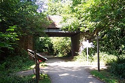
120:There is access from Brandy Hole Lane and the
263:
8:
270:
256:
248:
18:
169:. Local Nature Reserves. Natural England
147:. Local Nature Reserves. Natural England
133:
139:
137:
7:
516:Forests and woodlands of West Sussex
511:Local Nature Reserves in West Sussex
279:Local nature reserves in West Sussex
38:
198:National Heritage List for England
14:
46:
27:
328:The Brooks Local Nature Reserve
76:
68:
1:
480:Blunts Wood and Paiges Meadow
475:Bedelands Farm Nature Reserve
470:Ashenground and Bolnore Woods
102:. It is owned and managed by
94:on the western outskirts of
90:is a 6.5-hectare (16-acre)
485:Eastern Road Nature Reserve
104:Chichester District Council
81:Chichester District Council
532:
366:Burton and Chingford Ponds
167:"Map of Brandy Hole Copse"
35:
26:
124:runs through the site.
73:6.5 hectares (16 acres)
51:Chichester, West Sussex
92:Local Nature Reserve
43:Local Nature Reserve
230: /
145:"Brandy Hole Copse"
110:, Chichester Dyke.
465:Ardingly Reservoir
108:Scheduled Monument
106:. Part of it is a
498:
497:
386:Lynchmere Commons
361:Brandy Hole Copse
88:Brandy Hole Copse
85:
84:
22:Brandy Hole Copse
16:UK nature reserve
523:
419:Target Hill Park
391:Nutborne Marshes
310:Widewater Lagoon
272:
265:
258:
249:
245:
244:
242:
241:
240:
235:
234:50.852°N 0.791°W
231:
228:
227:
226:
223:
210:
209:
207:
205:
189:Historic England
185:
179:
178:
176:
174:
163:
157:
156:
154:
152:
141:
115:pipistrelle bats
65:
31:
19:
531:
530:
526:
525:
524:
522:
521:
520:
501:
500:
499:
494:
451:
442:Tottington Wood
428:
400:
347:
333:Fairmile Bottom
314:
281:
276:
238:
236:
232:
229:
224:
221:
219:
217:
216:
214:
213:
203:
201:
187:
186:
182:
172:
170:
165:
164:
160:
150:
148:
143:
142:
135:
130:
78:Managed by
61:
17:
12:
11:
5:
529:
527:
519:
518:
513:
503:
502:
496:
495:
493:
492:
487:
482:
477:
472:
467:
461:
459:
453:
452:
450:
449:
444:
438:
436:
430:
429:
427:
426:
424:Tilgate Forest
421:
416:
410:
408:
402:
401:
399:
398:
393:
388:
383:
378:
373:
368:
363:
357:
355:
349:
348:
346:
345:
340:
338:Pagham Harbour
335:
330:
324:
322:
316:
315:
313:
312:
307:
305:Shoreham Beach
302:
297:
291:
289:
283:
282:
277:
275:
274:
267:
260:
252:
239:50.852; -0.791
212:
211:
180:
158:
132:
131:
129:
126:
83:
82:
79:
75:
74:
71:
67:
66:
59:
53:
52:
49:
45:
44:
41:
37:
36:
33:
32:
24:
23:
15:
13:
10:
9:
6:
4:
3:
2:
528:
517:
514:
512:
509:
508:
506:
491:
490:Scrase Valley
488:
486:
483:
481:
478:
476:
473:
471:
468:
466:
463:
462:
460:
458:
454:
448:
445:
443:
440:
439:
437:
435:
431:
425:
422:
420:
417:
415:
414:Grattons Park
412:
411:
409:
407:
403:
397:
396:Pilsey Island
394:
392:
389:
387:
384:
382:
379:
377:
374:
372:
369:
367:
364:
362:
359:
358:
356:
354:
350:
344:
341:
339:
336:
334:
331:
329:
326:
325:
323:
321:
317:
311:
308:
306:
303:
301:
298:
296:
293:
292:
290:
288:
284:
280:
273:
268:
266:
261:
259:
254:
253:
250:
246:
243:
200:
199:
194:
190:
184:
181:
168:
162:
159:
146:
140:
138:
134:
127:
125:
123:
122:Centurion Way
118:
116:
111:
109:
105:
101:
97:
93:
89:
80:
72:
64:
60:
58:
54:
50:
42:
34:
30:
25:
20:
381:Iping Common
376:Harting Down
360:
295:Lancing Ring
215:
202:. Retrieved
196:
183:
171:. Retrieved
161:
149:. Retrieved
119:
112:
87:
86:
237: /
100:West Sussex
505:Categories
457:Mid Sussex
371:Eames Farm
353:Chichester
343:West Beach
222:50°51′07″N
128:References
96:Chichester
63:SU 852 065
300:Mill Hill
225:0°47′28″W
48:Location
447:Warnham
434:Horsham
406:Crawley
204:24 July
173:24 July
151:24 July
57:OS grid
320:Arun
287:Adur
206:2019
175:2019
153:2019
70:Area
40:Type
98:in
507::
195:.
191:.
136:^
117:.
271:e
264:t
257:v
208:.
177:.
155:.
Text is available under the Creative Commons Attribution-ShareAlike License. Additional terms may apply.