35:
242:
181:
307:
106:
283:
312:
302:
203:
276:
177:
fire in
October 2003 took two days to control, five days to die, and scarred Bradda Hill and other headlands around Fleshwick.
100:
269:
166:
60:
170:
158:
73:
34:
194:
162:
119:
114:
253:
78:
180:
296:
135:
249:
151:
147:
93:
241:
218:
205:
143:
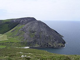
142:) is a headland some 2 kilometres (1.2 mi) north of the village of
50:
184:
View from Bradda Hill, looking towards Port St. Mary and
Castletown
179:
174:
169:. Cliffs drop from the summit down to the sea. It shelters
257:
154:
which is about 2 kilometres (1.2 mi) to the SW.
113:
99:
89:
84:
72:
59:
49:
44:
20:
277:
39:Bradda Hill from the north after a gorse fire
8:
284:
270:
17:
308:Mountains and hills of the Isle of Man
7:
238:
236:
14:
240:
150:. It is not to be confused with
33:
1:
256:. You can help Knowledge by
157:The path to the summit from
313:Isle of Man geography stubs
303:Marilyns of the Isle of Man
329:
235:
32:
25:
165:, the Isle of Man Coast
55:233 m (764 ft)
252:location article is a
185:
167:long distance footpath
183:
197:story about the fire
215: /
186:
45:Highest point
265:
264:
195:Isle of Man Guide
173:from the west. A
129:
128:
320:
286:
279:
272:
244:
237:
230:
229:
227:
226:
225:
220:
219:54.103°N 4.765°W
216:
213:
212:
211:
208:
109:
37:
18:
328:
327:
323:
322:
321:
319:
318:
317:
293:
292:
291:
290:
233:
223:
221:
217:
214:
209:
206:
204:
202:
201:
191:
163:Raad ny Foillan
161:is part of the
105:
40:
12:
11:
5:
326:
324:
316:
315:
310:
305:
295:
294:
289:
288:
281:
274:
266:
263:
262:
245:
224:54.103; -4.765
199:
198:
190:
187:
127:
126:
117:
111:
110:
103:
97:
96:
91:
87:
86:
82:
81:
76:
70:
69:
63:
57:
56:
53:
47:
46:
42:
41:
38:
30:
29:
23:
22:
13:
10:
9:
6:
4:
3:
2:
325:
314:
311:
309:
306:
304:
301:
300:
298:
287:
282:
280:
275:
273:
268:
267:
261:
259:
255:
251:
246:
243:
239:
234:
231:
228:
196:
193:
192:
188:
182:
178:
176:
172:
171:Fleshwick Bay
168:
164:
160:
155:
153:
149:
145:
141:
137:
133:
124:
121:
118:
116:
112:
108:
104:
102:
98:
95:
92:
88:
83:
80:
77:
75:
71:
67:
64:
62:
58:
54:
52:
48:
43:
36:
31:
28:
24:
19:
16:
258:expanding it
247:
232:
200:
156:
140:Cronk Vradda
139:
131:
130:
122:
65:
27:Cronk Vradda
26:
15:
222: /
159:Bradda West
152:Bradda Head
148:Isle of Man
132:Bradda Hill
94:Isle of Man
21:Bradda Hill
297:Categories
207:54°06′11″N
189:References
123:Landranger
61:Prominence
210:4°45′54″W
144:Port Erin
85:Geography
51:Elevation
115:Topo map
107:SC193711
90:Location
146:on the
101:OS grid
79:Marilyn
74:Listing
248:This
175:gorse
68:205 m
254:stub
250:Manx
136:Manx
299::
138::
125:95
120:OS
66:c.
285:e
278:t
271:v
260:.
134:(
Text is available under the Creative Commons Attribution-ShareAlike License. Additional terms may apply.