60:
780:
480:. This is a deep hole in the ground which is roughly 20 metres inland. It has a sea cave which funnels sea water into the hole, sometimes with such ferocity that the sea water blows out the top of the hole. The hole is situated to the north of the village and although it is large it can easily be missed because it is situated in a dip in the ground. There is no fencing around the hole making it a hazard to the unsuspecting walker.
785:
67:
469:
44:
546:
456:
245:
507:
which can be seen coming into villagers gardens in the evening. Other natives include rabbit, hare, rat, and feral cat. There have also been sightings of frogs in recent years which is a new addition to the area. There are regular sightings of seal fishing for salmon and sea trout in the
Brenish bay.
523:
The oceanic climate means that
Brenish experiences high volumes of rain, with temperatures struggling to reach double figures for a large part of the year. However, Brenish is far enough north to benefit from long summer days where there is daylight for over 20 hours. It is also a good place to view
412:
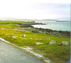
Brenish is commonly regarded as one of the more scenic areas on the island, although its remote location at the end of the winding and decaying C39 makes it one of the less visited. The village itself runs parallel to the
Atlantic coastline and is overlooked by Mealisval, the tallest mountain on the
536:
Brenish was once a highly populated village but has suffered a drastic decline in its numbers during the 1900s, brought about by a combination of the younger generation opting to move to the mainland and the demise of the ageing residents. There is very little employment in the local area and the
541:
has itself been in rapid decline since the 1980s. However, since the late 1990s the village has experienced a relative population boom. Over 50% of the population have migrated to
Brenish from the UK mainland which has brought with it a feeling of revival.
579:) population. To this end there is normally very little activity in the village on Sunday. Until relatively recent years even the act of watching television on Sunday would have been frowned upon.
303:
488:
The terrain is mainly heather covered moorland which is peppered with lochs of varying size, which are kept full by the plentiful supply of rain. This land contains high quantities of
311:
285:
293:
269:
496:
is peat cutting land which has supplied the village with fuel for decades. Due to the wild, damp, salty climate only hardy vegetation is able to survive.
710:
122:
231:
1400:
59:
567:
which itself leads down to the sea. There have been several new houses built since the late 1990s which are changing the face of the village.
404:. The name of the village is sometimes spelt Breanish (which is generally the spelling used locally), however maps normally refer to Brenish.
257:
618:
344:
329:
262:
563:
The architecture in the area is fairly typical for the island. Generally the houses are built beside the road, at the top of a
219:
185:
703:
1374:
167:
115:
644:
492:, which is still used by many in the village as a fuel source for heating and cooking. The land between Brenish and
334:
274:
696:
511:
Lewis provides a good stop off point for migrating birds which can be seen along with the hardy native seabirds.
437:
425:
381:
199:
149:
28:
678:
769:
824:
758:
804:
1329:
1117:
683:
673:
1379:
809:
477:
393:
1364:
977:
957:
894:
596:
493:
1350:
1345:
1298:
1167:
1162:
819:
814:
779:
719:
224:
108:
622:
1242:
1237:
1147:
874:
869:
525:
433:
250:
104:
452:
and 90 to 120 minutes from
Tarbert (depending on driving experience on the Lewis roads).
417:
which is an uninhabited village known best for its selection of virginal sandy beaches.
1197:
1182:
864:
859:
730:
175:
157:
80:
1394:
1314:
1137:
987:
834:
799:
764:
752:
389:
1359:
1288:
1227:
1057:
992:
576:
564:
512:
131:
1369:
1354:
1283:
1278:
1273:
1268:
1252:
1217:
1187:
1107:
1052:
1032:
942:
889:
879:
829:
784:
1293:
1222:
1192:
1172:
1157:
1142:
1132:
1012:
899:
854:
441:
421:
is where the road ends, making
Brenish the last populated village on the C39.
401:
139:
359:
346:
1324:
1247:
1232:
1212:
1112:
1087:
1077:
1072:
1042:
1007:
1002:
926:
884:
849:
844:
648:
449:
445:
429:
209:
1207:
1127:
1062:
1047:
962:
904:
735:
538:
444:. This route then travels along the B8011, which then becomes the C39 at
418:
414:
397:
191:
99:
1319:
1177:
1152:
1122:
1082:
1067:
1037:
1017:
982:
947:
937:
932:
545:
468:
455:
43:
1102:
1092:
997:
972:
967:
909:
839:
688:
1202:
1097:
952:
544:
500:
467:
454:
575:
Brenish, like all parts of the
Hebrides, has a strong religious (
515:
have also been known to make an occasional visit to the village.
1027:
504:
489:
692:
388:) is a small village situated on the west coast of the
476:
One of the more interesting features of
Brenish is the
503:
roaming freely and there is an increasing number of
1338:
1307:
1261:
918:
792:
744:
684:
Canmore - Lewis, Brenish, Military Camp site record
621:. Uig and Bernera Development Group. Archived from
448:. The journey takes between 60 and 90 minutes from
302:
284:
268:
256:
244:
230:
218:
208:
198:
184:
166:
148:
130:
114:
98:
90:
23:
704:
413:island. It is located next to the village of
8:
679:Canmore - Lewis, Breanis, School site record
711:
697:
689:
528:(otherwise known as the Northern Lights).
20:
588:
283:
239:
207:
183:
113:
40:
424:Brenish can be reached by taking the
301:
267:
255:
243:
229:
217:
197:
165:
147:
7:
674:Canmore - Lewis, Brenish site record
499:There are still a large number of
400:. Brenish is within the parish of
14:
783:
778:
65:
58:
42:
66:
1:
1401:Villages in the Isle of Lewis
18:Human settlement in Scotland
116:OS grid reference
1417:
537:traditional occupation of
776:
726:
436:, then turning on to the
320:
280:
240:
53:
41:
304:Scottish Parliament
647:. CBRD. Archived from
550:
473:
460:
385:
220:Postcode district
32:
1308:Geographical features
805:Eilean Chaluim Chille
548:
471:
458:
168:Lieutenancy area
597:"Details of Brenish"
312:Na h-Eileanan an Iar
294:Na h-Eileanan an Iar
200:Sovereign state
79:Location within the
1375:St Clement's Church
651:on 29 December 2014
392:, which is part of
356: /
1380:Teampall Mholuaidh
810:Eilean Chearstaidh
645:"C-Roads on Signs"
551:
474:
461:
394:the Outer Hebrides
286:UK Parliament
232:Dialling code
158:Na h-Eileanan Siar
1388:
1387:
958:Baile an Truiseil
745:Inhabited islands
625:on 2 October 2011
619:"Community Today"
599:. Scottish Places
375:
374:
150:Council area
48:Brenish coastline
1408:
1351:Clach an Trushal
1346:Callanish Stones
1339:Historical sites
860:Pabbay of Harris
820:Eilean Mhealasta
815:Eilean Liubhaird
787:
782:
720:Lewis and Harris
713:
706:
699:
690:
661:
660:
658:
656:
641:
635:
634:
632:
630:
615:
609:
608:
606:
604:
593:
371:
370:
368:
367:
366:
361:
360:58.122°N 7.110°W
357:
354:
353:
352:
349:
326:
194:
126:
125:
69:
68:
62:
46:
21:
1416:
1415:
1411:
1410:
1409:
1407:
1406:
1405:
1391:
1390:
1389:
1384:
1334:
1303:
1257:
1243:Tolsta Chaolais
914:
788:
774:
740:
722:
717:
670:
665:
664:
654:
652:
643:
642:
638:
628:
626:
617:
616:
612:
602:
600:
595:
594:
590:
585:
573:
561:
556:
534:
526:Aurora Borealis
521:
486:
484:Flora and fauna
466:
434:Tarbert, Harris
410:
382:Scottish Gaelic
364:
362:
358:
355:
350:
347:
345:
343:
342:
341:
324:
316:
298:
190:
180:
162:
144:
121:
120:
107:
105:Scottish Gaelic
86:
85:
84:
83:
77:
76:
75:
74:
70:
49:
37:
29:Scottish Gaelic
19:
12:
11:
5:
1414:
1412:
1404:
1403:
1393:
1392:
1386:
1385:
1383:
1382:
1377:
1372:
1367:
1362:
1357:
1348:
1342:
1340:
1336:
1335:
1333:
1332:
1327:
1322:
1317:
1311:
1309:
1305:
1304:
1302:
1301:
1296:
1291:
1286:
1281:
1276:
1271:
1265:
1263:
1259:
1258:
1256:
1255:
1250:
1245:
1240:
1235:
1230:
1225:
1220:
1215:
1210:
1205:
1200:
1195:
1190:
1185:
1180:
1175:
1170:
1165:
1160:
1155:
1150:
1145:
1140:
1135:
1130:
1125:
1120:
1115:
1110:
1105:
1100:
1095:
1090:
1085:
1080:
1075:
1070:
1065:
1060:
1055:
1050:
1045:
1040:
1035:
1030:
1025:
1020:
1015:
1010:
1005:
1000:
995:
990:
985:
980:
975:
970:
965:
960:
955:
950:
945:
940:
935:
930:
922:
920:
916:
915:
913:
912:
907:
902:
897:
892:
887:
882:
877:
872:
867:
862:
857:
852:
847:
842:
837:
832:
827:
822:
817:
812:
807:
802:
796:
794:
790:
789:
777:
775:
773:
772:
767:
762:
748:
746:
742:
741:
739:
738:
733:
731:Outer Hebrides
727:
724:
723:
718:
716:
715:
708:
701:
693:
687:
686:
681:
676:
669:
668:External links
666:
663:
662:
636:
610:
587:
586:
584:
581:
572:
569:
560:
557:
555:
552:
549:Mealista beach
533:
530:
520:
517:
485:
482:
472:The "Blowhole"
465:
462:
459:Mealista beach
409:
406:
373:
372:
365:58.122; -7.110
340:
339:
337:
332:
327:
325:List of places
321:
318:
317:
315:
314:
308:
306:
300:
299:
297:
296:
290:
288:
282:
281:
278:
277:
272:
266:
265:
260:
254:
253:
248:
242:
241:
238:
237:
234:
228:
227:
222:
216:
215:
212:
206:
205:
204:United Kingdom
202:
196:
195:
188:
182:
181:
179:
178:
172:
170:
164:
163:
161:
160:
154:
152:
146:
145:
143:
142:
136:
134:
128:
127:
118:
112:
111:
102:
96:
95:
92:
88:
87:
81:Outer Hebrides
78:
72:
71:
64:
63:
57:
56:
55:
54:
51:
50:
47:
39:
38:
36:
35:
25:
17:
13:
10:
9:
6:
4:
3:
2:
1413:
1402:
1399:
1398:
1396:
1381:
1378:
1376:
1373:
1371:
1368:
1366:
1363:
1361:
1358:
1356:
1352:
1349:
1347:
1344:
1343:
1341:
1337:
1331:
1328:
1326:
1323:
1321:
1318:
1316:
1315:Butt of Lewis
1313:
1312:
1310:
1306:
1300:
1297:
1295:
1292:
1290:
1287:
1285:
1282:
1280:
1277:
1275:
1272:
1270:
1267:
1266:
1264:
1260:
1254:
1251:
1249:
1246:
1244:
1241:
1239:
1236:
1234:
1231:
1229:
1226:
1224:
1221:
1219:
1216:
1214:
1211:
1209:
1206:
1204:
1201:
1199:
1196:
1194:
1191:
1189:
1186:
1184:
1181:
1179:
1176:
1174:
1171:
1169:
1166:
1164:
1161:
1159:
1156:
1154:
1151:
1149:
1146:
1144:
1141:
1139:
1136:
1134:
1131:
1129:
1126:
1124:
1121:
1119:
1116:
1114:
1111:
1109:
1106:
1104:
1101:
1099:
1096:
1094:
1091:
1089:
1086:
1084:
1081:
1079:
1076:
1074:
1071:
1069:
1066:
1064:
1061:
1059:
1056:
1054:
1051:
1049:
1046:
1044:
1041:
1039:
1036:
1034:
1031:
1029:
1026:
1024:
1021:
1019:
1016:
1014:
1011:
1009:
1006:
1004:
1001:
999:
996:
994:
991:
989:
988:Borve, Harris
986:
984:
981:
979:
976:
974:
971:
969:
966:
964:
961:
959:
956:
954:
951:
949:
946:
944:
941:
939:
936:
934:
931:
929:
928:
924:
923:
921:
917:
911:
908:
906:
903:
901:
898:
896:
893:
891:
888:
886:
883:
881:
878:
876:
873:
871:
868:
866:
863:
861:
858:
856:
853:
851:
848:
846:
843:
841:
838:
836:
833:
831:
828:
826:
823:
821:
818:
816:
813:
811:
808:
806:
803:
801:
800:Bayble Island
798:
797:
795:
793:Other islands
791:
786:
781:
771:
768:
766:
765:Great Bernera
763:
761:
760:
755:
754:
750:
749:
747:
743:
737:
734:
732:
729:
728:
725:
721:
714:
709:
707:
702:
700:
695:
694:
691:
685:
682:
680:
677:
675:
672:
671:
667:
650:
646:
640:
637:
624:
620:
614:
611:
598:
592:
589:
582:
580:
578:
570:
568:
566:
558:
553:
547:
543:
540:
531:
529:
527:
518:
516:
514:
513:Golden eagles
509:
506:
502:
497:
495:
491:
483:
481:
479:
470:
463:
457:
453:
451:
447:
443:
439:
435:
431:
427:
422:
420:
416:
407:
405:
403:
399:
395:
391:
390:Isle of Lewis
387:
383:
379:
369:
338:
336:
333:
331:
328:
323:
322:
319:
313:
310:
309:
307:
305:
295:
292:
291:
289:
287:
279:
276:
273:
271:
264:
261:
259:
252:
249:
247:
235:
233:
226:
223:
221:
214:ISLE OF LEWIS
213:
211:
203:
201:
193:
189:
187:
177:
176:Western Isles
174:
173:
171:
169:
159:
156:
155:
153:
151:
141:
138:
137:
135:
133:
129:
124:
119:
117:
110:
106:
103:
101:
97:
93:
89:
82:
61:
52:
45:
34:
30:
27:
26:
22:
16:
1360:Dun Carloway
1228:South Galson
1022:
993:Borve, Lewis
925:
757:
751:
653:. Retrieved
649:the original
639:
627:. Retrieved
623:the original
613:
601:. Retrieved
591:
577:Presbyterian
574:
562:
559:Architecture
535:
522:
510:
498:
487:
475:
423:
411:
377:
376:
132:Civil parish
15:
1370:Lews Castle
1365:Dùn Èistean
1355:Steinacleit
1330:Eilean Glas
1279:North Lochs
1218:Shulishader
1198:Rèinigeadal
1188:Portnaguran
1033:Cabharstadh
919:Settlements
880:Sgeotasaigh
865:Pabaigh Mòr
830:Fuaigh Beag
655:26 December
629:26 December
603:26 December
363: /
1223:South Dell
1193:Portvoller
1173:North Dell
1158:New Tolsta
1143:Lingarabay
1133:Leverburgh
1013:Breasclete
978:Borghastan
900:Sula Sgeir
895:Stockinish
855:North Rona
835:Fuaigh Mòr
583:References
532:Demography
442:Garynahine
348:58°07′19″N
91:Population
1325:The Minch
1299:West Side
1262:Districts
1248:Timsgarry
1233:Swainbost
1213:Skigersta
1168:Newvalley
1163:Newmarket
1113:Hushinish
1088:Garrabost
1078:Flesherin
1073:Fivepenny
1043:Callanish
1008:Breaclete
1003:Branahuie
927:Stornoway
885:Soay Beag
850:Killegray
845:Hermetray
554:Community
450:Stornoway
446:Timsgarry
430:Stornoway
408:Geography
351:7°06′36″W
270:Ambulance
210:Post town
1395:Category
1208:Shawbost
1148:Marybank
1128:Leurbost
1063:Eorodale
1048:Carloway
963:Balallan
905:Taransay
890:Soay Mòr
875:Seaforth
736:Scotland
571:Religion
539:crofting
478:Blowhole
440:towards
419:Mealista
415:Mealista
398:Scotland
335:Scotland
275:Scottish
263:Scottish
251:Scotland
192:Scotland
123:NA991261
100:Language
94:25
1320:Clisham
1238:Tarbert
1183:Parkend
1178:Orinsay
1153:Melbost
1123:Laxdale
1083:Garenin
1068:Eoropie
1038:Calbost
1023:Brenish
1018:Breivig
983:Borsham
948:Ardroil
938:Aignish
933:Adabroc
770:Scalpay
519:Climate
494:Islivig
464:Geology
386:Brèinis
378:Brenish
186:Country
109:English
73:Brenish
33:Brèinis
24:Brenish
1138:Lionel
1103:Habost
1093:Gravir
998:Bragar
973:Bayble
968:Barvas
910:Vacsay
840:Gasker
759:Harris
246:Police
1289:Point
1203:Rodel
1118:Knock
1098:Gress
1058:Cross
953:Arnol
870:Scarp
825:Ensay
753:Lewis
565:croft
501:sheep
428:from
236:01851
1353:and
1284:Park
1274:Ness
1269:Back
1253:Tong
1108:Holm
1053:Coll
1028:Brue
943:Aird
756:and
657:2014
631:2014
605:2014
524:the
505:deer
490:peat
438:A858
426:A859
258:Fire
1294:Uig
432:or
402:Uig
396:of
225:HS2
140:Uig
1397::
384::
330:UK
31::
712:e
705:t
698:v
659:.
633:.
607:.
380:(
Text is available under the Creative Commons Attribution-ShareAlike License. Additional terms may apply.