29:
42:
49:
329:, situated in eastern Gauteng. Then before it bends northeastwards it passes by the Bronkhorstspruit urban area. It finally has a confluence with the Wilge River some 10 km east of the town, at Premiermyn Dam, Gauteng.
456:"Vlakfontein: AIA-270716 (A Phase 1 Archaeological Impact Assessment for I-Cat International Consulting & Trading (Pty) Ltd on a Portion of Portion 25 of the Farm Vlakfontein 523 JR, Bronkhorstspruit, Gauteng)"
355:, a battle between a Boer commando under the command of Frans Joubert and British troops under Lieutenant-Colonel Anstruther. It was one of the first serious clashes in the early days of the
390:
41:
507:
351:, and on Merensky's map of 1875 it (including the current lower Wilge) is the Rhenosterpoortrivier. In 1880 this river was the scene of the
455:
512:
532:
492:
187:
431:
385:
542:
409:
537:
352:
338:
28:
295:
291:
160:
517:
368:
326:
373:
102:
322:
247:
348:
488:
442:
420:
347:
arrived at it in 1858, they called it the
Kalkoenkransrivier, suggesting a breeding site of
318:
299:
173:
134:
98:
356:
526:
121:
344:
279:
88:
155:
314:
271:
261:
70:
202:
189:
66:
311:
275:
518:
Channel Slopes in the
Olifants, Crocodile and Sabie River Catchments
325:, joins its left bank. Further downstream it flows into the
321:. It flows generally northwards and its main tributary, the
317:
241:
233:
228:
218:
179:
166:
154:
140:
127:
117:
108:
94:
84:
79:
61:
21:
65:Likely named after "bronkors" or "bronkhorst" the
282:. In the 19th century it as was known as the
16:River in Gauteng and Mpumalanga, South Africa
8:
298:basin, and it lends its name to the town of
391:List of reservoirs and dams in South Africa
410:Dictionary of Southern African Place Names
48:
402:
508:The Olifants River Basin, South Africa
18:
302:, situated mainly on its right bank.
7:
454:Coetzee, Tobias (September 2016).
14:
487:Oxford, Osprey Publishing, 1996,
485:Majuba 1881: The Hill of Destiny.
47:
40:
27:
310:Its sources are located in the
386:List of rivers of South Africa
181: • coordinates
1:
109:Physical characteristics
224:1,370 m (4,490 ft)
220: • elevation
146:1,630 m (5,350 ft)
142: • elevation
290:. It is a tributary of the
168: • location
129: • location
559:
353:action at Bronkhorstspruit
339:Action at Bronkhorstspruit
336:
432:The Olifants River System
150:
113:
35:
26:
533:Olifants River (Limpopo)
513:Olifants River Catchment
243: • left
74:(Nasturtium officinale)
161:Wilge River (Olifants)
203:25.80833°S 28.85278°E
543:Rivers of Mpumalanga
369:Bronkhorstspruit Dam
327:Bronkhorstspruit Dam
288:Rhenosterpoortrivier
270:, is a river in the
463:sahris.sahra.org.za
229:Basin features
208:-25.80833; 28.85278
199: /
284:Kalkoenkransrivier
538:Rivers of Gauteng
363:Dams in the river
257:Bronkhorst Spruit
253:
252:
22:Bronkhorst Spruit
550:
495:
481:
475:
474:
472:
470:
460:
451:
445:
440:
434:
429:
423:
418:
412:
407:
343:When a group of
319:Springs, Gauteng
300:Bronkhorstspruit
244:
214:
213:
211:
210:
209:
204:
200:
197:
196:
195:
192:
174:Bronkhorstspruit
143:
135:Springs, Gauteng
130:
51:
50:
44:
31:
19:
558:
557:
553:
552:
551:
549:
548:
547:
523:
522:
504:
499:
498:
482:
478:
468:
466:
458:
453:
452:
448:
441:
437:
430:
426:
419:
415:
408:
404:
399:
382:
365:
341:
335:
308:
242:
221:
207:
205:
201:
198:
193:
190:
188:
186:
185:
182:
169:
141:
128:
57:
56:
55:
54:
53:
52:
17:
12:
11:
5:
556:
554:
546:
545:
540:
535:
525:
524:
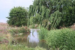
521:
520:
515:
510:
503:
502:External links
500:
497:
496:
476:
446:
443:Olifants WMA 4
435:
424:
421:Olifants WMA 4
413:
401:
400:
398:
395:
394:
393:
388:
381:
378:
377:
376:
374:Premiermyn Dam
371:
364:
361:
357:First Boer War
337:Main article:
334:
331:
307:
304:
296:Olifants River
251:
250:
245:
239:
238:
235:
231:
230:
226:
225:
222:
219:
216:
215:
183:
180:
177:
176:
170:
167:
164:
163:
158:
152:
151:
148:
147:
144:
138:
137:
131:
125:
124:
119:
115:
114:
111:
110:
106:
105:
96:
92:
91:
86:
82:
81:
77:
76:
63:
59:
58:
46:
45:
39:
38:
37:
36:
33:
32:
24:
23:
15:
13:
10:
9:
6:
4:
3:
2:
555:
544:
541:
539:
536:
534:
531:
530:
528:
519:
516:
514:
511:
509:
506:
505:
501:
494:
493:1-85532-503-9
490:
486:
483:Castle, Ian.
480:
477:
464:
457:
450:
447:
444:
439:
436:
433:
428:
425:
422:
417:
414:
411:
406:
403:
396:
392:
389:
387:
384:
383:
379:
375:
372:
370:
367:
366:
362:
360:
358:
354:
350:
346:
340:
332:
330:
328:
324:
320:
316:
313:
305:
303:
301:
297:
293:
289:
285:
281:
278:provinces of
277:
273:
269:
265:
263:
258:
249:
246:
240:
236:
232:
227:
223:
217:
212:
184:
178:
175:
171:
165:
162:
159:
157:
153:
149:
145:
139:
136:
132:
126:
123:
122:Witwatersrand
120:
116:
112:
107:
104:
100:
97:
93:
90:
87:
83:
78:
75:
72:
68:
64:
60:
43:
34:
30:
25:
20:
484:
479:
467:. Retrieved
465:. p. 17
462:
449:
438:
427:
416:
405:
345:Voortrekkers
342:
323:Delmas River
309:
287:
283:
280:South Africa
267:
260:
256:
254:
248:Delmas River
89:South Africa
73:
469:23 November
292:Wilge River
234:Tributaries
206: /
527:Categories
397:References
315:grasslands
272:Mpumalanga
262:watercress
259:, meaning
194:28°51′10″E
191:25°48′30″S
103:Mpumalanga
71:watercress
349:bald ibis
69:word for
67:Afrikaans
62:Etymology
380:See also
312:highveld
172:East of
133:East of
80:Location
333:History
294:in the
276:Gauteng
99:Gauteng
85:Country
491:
306:Course
264:stream
237:
118:Source
459:(PDF)
268:creek
156:Mouth
95:State
489:ISBN
471:2021
274:and
255:The
101:and
286:or
266:or
529::
461:.
359:.
473:.
Text is available under the Creative Commons Attribution-ShareAlike License. Additional terms may apply.