1277:
92:
1091:, with 93.3% of its 2,063 households owning homes, which compares to a national average of 66.2% for home ownership. A large portion of the homes in Brookeville were built during the 1990s, as well as a large number built in the 1970s. As reported in the 2000 census, 30% of homes within the Brookeville ZIP Code were built during the 1990s, 15.6% during the 1980s, 35.6% in the 1970s, 13% between 1940 and 1970, and 5.7% before 1940. 54% of the population had moved into their homes during the 1990s, 22.9% in the 1980s, 17.5% in the 1970s, and 5.6% have lived in the same home since before 1970. The median purchase price for homes in the Brookeville area in 2006 was $ 546,500, which compares to $ 475,000 for all of Montgomery County, and $ 243,750 for the entire United States.
42:
2639:
2519:
69:
748:
606:
3182:
1228:
1461:
41:
513:. Thomas Mill was located on the east side of town. To transport goods more easily to markets in Washington, D.C., a prosperous farmer established a company in 1849 to build a toll road to connect Brookeville to the Seventh Street Pike. The turnpike was sold to the state of Maryland in 1914, and later became Georgia Avenue, now
3170:
649:
was an important stop. Historians suggest that the
Madison House was also used as a stop on the Underground Railroad during the Civil War. Part of the Madison House once served as the town's post office. A false stone wall in the room hid a staircase that descended in two directions, including into a
1055:
living together, 11.4% had a female householder with no husband present, and 31.8% were non-families. 18.2% of all households were made up of individuals, and 9.1% had someone living alone who was 65 years of age or older. The population density was 933.6 inhabitants per square mile (360.5/km). The
492:
Richard Thomas and his wife
Deborah Brooke founded the town of Brookeville in 1794, and named it after her family. The town was established on land inherited by Deborah Brooke from her father Roger Brooke IV, son of an influential Quaker landholder, James Brooke. At the time, Brooke was the largest
461:
have also experienced rapid population growth. Georgia Avenue carries a substantial volume of traffic through the town, from these areas to the north into
Montgomery County and Washington, D.C. In 1966, county planning officials recommended that a bypass be built to carry commuters around the town.
1154:
living together, 1.9% had a female householder with no husband present, 1.9% had a male householder with no wife present, and 29.6% were non-families. 22.2% of all households were made up of individuals, and 9.3% had someone living alone who was 65 years of age or older. The average household size
710:
The Town of
Brookeville is formally incorporated, and covers an area of 0.1 square miles (0.26 km). Areas beyond the formal town boundaries, extending to the Howard County boundary, use Brookeville mailing addresses, falling within the 20833 ZIP Code. Located within the ZIP Code are the small
658:
In 1910, the Salem United
Methodist Church was built to replace a church that had been destroyed by fire, and the church cemetery has been there since the mid-19th century. By 1900, the mills and shops had shut down, and Brookeville remained a residential town. In 1915, the Bentley family sold the
504:
industry in the surrounding area. During the 19th century, Brookeville was home to several mills, the
Brookeville Academy (initially a boys' school), a post office, a blacksmith's shop, St. Luke's Episcopal Church, Salem Methodist Protestant Church, and a number of shops. Newlin's Mill, located on
1110:
time is 35.9 minutes, with 84.1% driving alone, 9% carpooling, 2.3% using public transportation, and 3.1% working at home. Most people are employed in management, professional, and related occupations, with 59.5% in those types of jobs. 19.3% are employed in sales and office occupations, 10.7% in
1248:
The
Longwood School for Boys was a private school that was established in 1946 by George F. Kimmell, who had bought Longwood Manor. In 1952, Kimmell leased the school facilities to the Civil Defense Administration, which used it for military training. The school was vacated in 1963, and remained
738:
Georgia Avenue, which begins in
Washington, D.C., is a two-lane road when it passes through Brookeville, with a stop sign and tight turn that takes it through the historic district. In 1989, the road carried 8,000 vehicles daily, a number which had increased to 18,000 vehicles each weekday as of
528:, and coining the term. He created a portable contraption to transport butter and other products to sell at markets in Washington. His products commanded a high price, due to the extra freshness of the products at the market. Moore lived near the town, at Longwood Manor, which was built in 1817.
780:
maintains 6,000 acres (24 km), in and around the reservoir, which are open to the public for recreational purposes. The reservoir is a popular recreation spot that is suitable for fishing, kayaking, and other activities. Mount Zion Park is a small park with playgrounds, ball fields, tennis
775:
and to the east of
Brookeville. Patuxent River State Park is used for hunting, fishing, hiking and horseback riding. Rachel Carson Conservation Park, located to the north, is undeveloped and has a number of hiking trails. The Triadelphia Reservoir, created by the Brighton Dam, is located on the
743:
and Howard County. The traffic volume on
Georgia Avenue is more than the road was designed to handle. Brookeville residents have advocated for a bypass road to be constructed, to take traffic around the town. The bypass road around the town was in the planning stages for some time, since being
587:
Finding that our army has left Montgomery Court House, we pushed on to this place, with a view to join it, or proceed to the city, as further information might prescribe. I have just received a line from Col. Monroe saying that the enemy were out of Washington on the retreat to their ships and
91:
1158:
The median age in the town was 46.3 years. 22.4% of residents were under the age of 18; 4.4% were between the ages of 18 and 24; 20.9% were from 25 to 44; 38% were from 45 to 64; and 14.2% were 65 years of age or older. The gender makeup of the town was 53.7% male and 46.3% female.
1179:
Ordinance in 1986, which guides town planning and restricts development within the town. The town commission consists of three members, who are elected for two-year terms. Michael Acierno was elected in May 2007 as president of the Brookeville Town Commission.
1235:
The Brookeville Academy, a preparatory school established in 1814, was one of the first schools in the county. Among those educated at the Academy, include Dr. Henry Howard, who established Howard County, and William Edward Magruder, great-grandson of Colonel
1276:
687:
444:
border, and including the small hamlets of Sunshine and Brighton. Reddy Branch Stream Valley Park surrounds the Town of Brookeville, with the creek flowing west to east towards the Patuxent. Other parks and recreational areas include
1244:
and other organizations. On June 2, 1909, the Public School Board took over running the school. In 1988, the original building was sold to the Town of Brookeville, which maintains the building as a historic site and use for events.
744:
recommended by county planning officials in 1966. The bypass road will include two roundabouts, one on either side of the town. The project was under construction as of May 2019 and was nearly complete by the fall of 2022.
621:
and later free black families. The Oakley Cabin is now maintained by the Montgomery County Department of Parks. A number of other 18th and 19th century cabins still exist on private property in the Brookeville area.
1111:
service occupations, 5.7 in construction, extraction, and maintenance occupations, and 4.9% in production, transportation, and material moving occupations. 24.4% of those in the labor force are government workers.
659:
Madison House to Roger Brooke, a leader of the Quaker community. The house later changed hands, owned for some time by Elisha Hall, a principal at the Brookeville Academy, banker Remus Riggs, and Gene Archer, an
781:
courts, and picnic facilities. Within the town limits, Powers' Woods Park is a new 2-acre (8,100 m) park that is slated to be located near a recently restored one-room schoolhouse.
1072:
of any race were 2.50% of the population. The median age was 39 years. The median income for a household in the town was $ 88,629, and the median income for a family was $ 93,444. The
2049:
1127:
was 1,116.7 inhabitants per square mile (431.2/km). There were 57 housing units at an average density of 475.0 per square mile (183.4/km). The racial makeup of the town was 88.8%
579:
Madison stayed up all night, dispatching orders, while soldiers remained on guard outside. After the British left Washington, they sailed to nearby Baltimore, where they attacked
2565:
2533:
2128:
469:
or related professional jobs. The town is governed by a three-person town commission, while surrounding unincorporated areas are administered by the county. Historically, the
1240:. In 1869, the Brookeville Academy relocated to Merrywood, located on nearby farmland outside of town. The original building has since been used as a meeting facility by the
2376:
1087:. The median age is 37.5, and the racial composition is 84.1% Caucasian, 6.7% African-American, 6% Asian, and 3.6% Hispanic. The Brookeville area has a very high rate of
497:
opened a store and a post office in 1802, becoming the first postmaster of Brookeville. The town's charter was approved in 1808, though not formally issued until 1890.
641:. This was one of three groups of troops that came from different directions towards Antietam. The Quakers played an instrumental role in aiding escaped slaves on the
1249:
vacant until 1978, when it was converted into a community recreation center. The Longwood Recreation Center is run by the Montgomery County Recreation Department.
3232:
3217:
3212:
1171:
as a town in 1808 and the charter formally issued in 1890. Town commissioners oversee the government, handling street maintenance and other matters, as well as
767:. Reddy Branch Stream Valley Park is located along Brookeville Road, to the west of the town, and to the east along Brighton Dam Road. Hawling Hills Park and
3110:
1997:
1253:
588:
advising our immediate return to Washington. I know not where we are in the first instance to hide our heads; but shall look for a place on my arrival.
2558:
3207:
3202:
1208:
2075:
1772:
1633:
2724:
1659:
777:
466:
326:
2207:
113:
3085:
1971:
1051:, the town had a population of 120; there were 44 households, out of which 38.6% had children under the age of 18 living with them, 52.3% were
68:
1287:
is the only state highway serving Brookeville directly. MD 97 follows High Street and Market Street within the town limits, becoming known as
1268:
and Sherwood Elementary School. Up until 1992, when Rosa Parks Middle School opened, all of Brookeville was within the Farquhar service area.
493:
landholder in what would become Montgomery County. Thomas set up a mill, along the Reddy Branch, which forms the northern border of the town.
3090:
3055:
2417:
2258:
2102:
1883:
46:
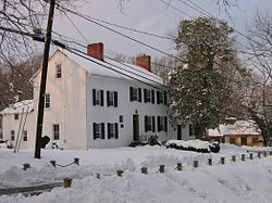
The Madison House in February 2006. It was built around 1800 and originally owned by Caleb Bentley. The house provided refuge for President
2882:
2551:
675:
2053:
1663:
1098:, which compares to the national average of 24.4%. The median household income is $ 103,879, compared to a national average of $ 41,994.
2736:
336:
2741:
719:), which is a major north–south route through this part of Maryland, passes through the town. Brookeville Road connects the town with
1291:
outside of town both to the north and south. After departing Brookeville, MD 97 heads north 10 miles (16 km) to a junction with
3070:
1265:
1731:
Rauschart, Lisa (November 2, 2006). "Road Markers Offer History at Any Speed; Stories They Tell Usually Interesting, Often True".
1397:
790:
386:
277:
2756:
2543:
474:
1957:
1260:
school and became a public school in 1909. Most of Brookeville, including the town proper, is located in the service area for
3222:
1083:
The larger area defined as Brookeville by the postal service, within the 20833 ZIP Code, has a population of 6,259 as of the
521:
436:(USPS) defines a larger area as Brookeville than what falls within the town boundaries. This includes areas extending to the
3115:
1436:
1548:
2786:
2679:
2380:
671:
583:
and were repulsed. Upon hearing that news, Madison returned to Washington. Madison wrote a note to his wife that morning.
3160:
1746:
1514:
2918:
2751:
2669:
1566:
1488:
1257:
618:
478:
433:
169:
670:
taking prominence over Brookeville. Since the 1950s, Olney has rapidly developed, putting pressure on Brookeville. The
2827:
2761:
2575:
2335:
2186:
1184:
1061:
366:
174:
97:
789:
The climate in this area is characterized by hot, humid summers and generally mild to cool winters. According to the
2023:
3227:
3060:
2958:
2928:
2714:
2674:
2481:
1304:
1323:(born 1969), chancellor of the University of Pittsburgh; resided in Brookville for 20 years while working at NIST
1308:
1296:
1292:
1084:
1026:
1011:
996:
981:
966:
951:
936:
921:
906:
891:
876:
861:
846:
831:
794:
768:
450:
394:
2001:
564:, however. Madison continued eastward and arrived in Brookeville on horseback. He reportedly carried with him a
2968:
2923:
1261:
740:
520:
Brookeville was home to Thomas Moore Jr., who along with Caleb Bentley was instrumental in the creation of the
458:
314:
145:
1421:
1102:
is $ 40,540 compared to $ 21,587 for all of the United States. 76.2% of the population over age 16 is in the
3138:
2953:
2933:
2913:
2776:
2528:
1863:
699:
441:
3100:
2963:
2877:
2811:
2699:
2684:
2618:
1212:
1140:
1065:
720:
646:
446:
417:
319:
613:
The Oakley Farm, located on the western edge of Brookeville, thrived during the 18th and 19th centuries.
3105:
3040:
3030:
3010:
2872:
2867:
2806:
2704:
2659:
2628:
2079:
1776:
1300:
1204:
1176:
1168:
764:
541:
454:
401:
382:
189:
1927:
Lipton, Eric (September 6, 1994). "Commuters Cause Big Traffic Problems Passing Through Little Towns".
1264:
and Greenwood Elementary School. Some areas, bordering Howard County, are located the service area for
1150:
There were 54 households, of which 33.3% had children under the age of 18 living with them, 66.7% were
1094:
The population in the Brookeville area is well-educated, with 57.6% of those age 25 or older having a
465:
Brookeville is an affluent residential community, with a large portion of residents employed with the
3145:
3065:
2897:
2887:
2852:
2842:
2832:
2816:
2791:
2694:
1320:
1196:
1144:
1069:
728:
642:
421:
287:
1975:
694:
Brookeville is located in northeastern Montgomery County, Maryland, 3 miles (5 km) west of the
3045:
3025:
2993:
2983:
2903:
2821:
2801:
2689:
2623:
2597:
1326:
1132:
1128:
1076:
for the town was $ 43,483. There were 7.1% of families and 5.5% of the population living below the
1057:
630:
553:
470:
2262:
2106:
1887:
3020:
2973:
2892:
2862:
2847:
2837:
2796:
2746:
2709:
1136:
1124:
732:
638:
626:
413:
2456:
2442:
2153:
568:, which contained the entire U.S. treasury. On the night of August 26, he stayed in the home of
3080:
3075:
2978:
2948:
2943:
2908:
2857:
2766:
2291:
1311:
just outside of Washington, D.C. The name "Georgia Avenue" follows US 29 south into the city.
1284:
1099:
1095:
1073:
755:
Reddy Branch flows along the northern and eastern edges of the town. It is a tributary of the
747:
724:
716:
605:
557:
514:
1835:
1280:
MD 97 northbound in Brookeville, just before turning left from High Street onto Market Street
3174:
3095:
3005:
772:
707:
370:
51:
3186:
3050:
3035:
3015:
2938:
1241:
1192:
703:
667:
374:
1123:
of 2010, there were 134 people, 54 households, and 38 families residing in the town. The
666:
The automobile gave people more mobility and changed the market, with the nearby town of
544:
parts of Washington, D.C., the federal government and troops fled the capital. President
1693:
2518:
1332:
1288:
1237:
1088:
760:
756:
712:
695:
573:
481:
school and became a public school in 1909, serving Brookeville and other nearby areas.
437:
3196:
2285:
1958:"MD 0097 BROOKEVILLE BYPASS IHB - SOUTH OF BROOKEVILLE TO MD 97 NORTH OF BROOKEVILLE"
1172:
678:
in 1979. Brookeville's historic designation has helped it retain historic character.
593:
569:
545:
494:
409:
400:
Brookeville is notable as the "United States Capital for a Day": when British troops
150:
47:
1813:
1346:
1336:
1227:
1216:
1200:
1077:
580:
525:
1750:
1912:
Levy, Claudia (November 18, 1989). "Brookeville: Montgomery's Link to Its Past".
1422:
U.S. Geological Survey Geographic Names Information System: Brookeville, Maryland
2590:
1437:"P1. Race – Brookeville town, Maryland: 2020 DEC Redistricting Data (PL 94-171)"
1188:
1103:
537:
501:
405:
55:
1329:(born 1935), former member of the Maryland State Senate; resides in Brookeville
1256:
system, and is served by Sherwood High School, which first opened in 1883 as a
1518:
634:
506:
389:, Brookeville is now at the northern edge of the densely developed Washington
157:
2232:
1570:
1492:
128:
115:
1716:
Richman, Michael (August 27, 1996). "Brookeville: Where time stands still".
1107:
686:
614:
561:
268:
2339:
3129:‡This populated place also has portions in an adjacent county or counties
2027:
1151:
1052:
549:
302:
162:
101:
2485:
2052:. Maryland Department of Natural Resources. June 2, 2004. Archived from
1349:(born 1975), member of the Maryland State Senate; resides in Brookeville
637:
troops (the First and Ninth Corps) through Brookeville, on their way to
617:, dating from the 1820s, were built on the Oakley/Dorsey farm, to house
2524:
510:
258:
1120:
1048:
489:
473:
was an important educational institution for the community. In 1883,
390:
378:
2208:"Housing Outlook 2007 – Regional Property Values, Montgomery County"
2512:
2129:"Brookeville, Maryland Köppen Climate Classification (Weatherbase)"
1372:
1367:
1365:
1363:
1275:
1226:
746:
685:
604:
294:
273:
351:
2649:
2608:
2537:
1679:
In the Greatest Solemn Dignity – The Capitol's Four Cornerstones
1340:
565:
32:
2547:
1692:
Browning, Charles Henry (1895). "President Madison's Retreat".
1814:"Pathways to Freedom: Maryland & the Underground Railroad"
1595:
660:
650:
hidden area in the basement where escaped slaves could hide.
2637:
1974:. Maryland Department of Natural Resources. Archived from
1303:, while 12 miles (19 km) to the south, it intersects
2379:. Montgomery County Recreation Department. Archived from
2233:"Median and Average Sales Price of Houses Sold by Region"
2182:
2026:. Washington Suburban Sanitary Commission. Archived from
457:. Areas to the north of Brookeville in Howard County and
412:
sought refuge in the town on August 26, 1814. During the
1843:
556:
at 6 p.m. on August 26, 1814, expecting to find General
2078:. Montgomery County Department of Parks. Archived from
2000:. Montgomery County Department of Parks. Archived from
1775:. Montgomery County Department of Parks. Archived from
1634:"If Refrigerators Could Speak, The Stories They'd Tell"
560:
and his troops. They had already proceeded on towards
524:. Moore is also credited as the inventor of the first
3158:
2284:
Montgomery Gambrill, John; M. Bates Stephens (1904).
1392:
1390:
572:, whose wife Henrietta Thomas was close friends with
2307:
The Transactions of the American Medical Association
1590:
1588:
739:
2007. The traffic mainly consists of commuters from
735:), then the Patuxent River, and into Howard County.
3124:
2992:
2775:
2723:
2648:
2607:
346:
335:
325:
313:
301:
284:
267:
256:
248:
240:
235:
227:
219:
211:
203:
198:
188:
180:
168:
156:
144:
23:
1660:"You Won't Need Much Time to Tour This 'Capital'"
771:are located along New Hampshire Avenue, north of
702:border. The town is 2 miles (3 km) north of
84:"United States Capital For A Day August 26, 1814"
1862:Hahn, Roberta & Josephine Unglesbee (1994).
2177:
2175:
2173:
2171:
1155:was 2.48 and the average family size was 2.95.
585:
462:The project was under construction as of 2022.
50:, on August 26, 1814, after the British burned
1840:National Register of Historic Places Inventory
505:the west side of town, processed high-quality
2559:
2443:"Karen S. Montgomery, Maryland State Senator"
2321:Year Book of the American Clan Gregor Society
1749:. Montgomery Parks Foundation. Archived from
1431:
1429:
8:
2259:"Acierno to serve as 'mayor' of Brookeville"
1483:
1481:
1479:
1456:
1454:
706:and 20 miles (32 km) north of downtown
500:Brookeville served as a market town for the
690:North on Georgia Ave into Brookeville, 2006
369:, located 20 km (12 mi) north of
2566:
2552:
2544:
2517:
2103:"Brookeville closer to new outdoor common"
1857:
1855:
1853:
1711:
1709:
1707:
1705:
1549:"Charms and Challenges Of a Tiny Old Town"
1147:of any race were 11.2% of the population.
804:
100:, Inset: Location of Montgomery County in
20:
2484:. Friends of Craig Zucker. Archived from
2402:Barrow, Healan; Kristine Stevens (2000).
2361:Barrow, Healan; Kristine Stevens (2000).
1842:. Maryland Historic Trust. Archived from
1800:Death in September: The Antietam Campaign
1617:Barrow, Healan; Kristine Stevens (2000).
1802:. McWhiney Foundation Press. p. 26.
1596:"National Register Listings in Maryland"
1547:Siegal, Ann Cameron (December 1, 2007).
1542:
1540:
1538:
1536:
3165:
1907:
1905:
1698:. Historical Register Pub. p. 860.
1359:
778:Washington Suburban Sanitary Commission
552:, but then turned north. He arrived in
373:, and 2 km (1.2 mi) north of
345:
324:
300:
266:
234:
226:
197:
179:
143:
108:
88:
80:
62:
38:
2365:. Willow Bend Books. pp. 117–118.
1884:"One man's fight to preserve the past"
1653:
1651:
1649:
1647:
1417:
1415:
824:
2323:. American Clan Gregor Society. 1912.
2305:American Medical Association (1874).
2024:"Watershed Recreational User Program"
1569:. Sandy Spring Museum. Archived from
1517:. Town of Brookeville. Archived from
1491:. Sandy Spring Museum. Archived from
1398:"2022 U.S. Gazetteer Files: Maryland"
1209:Maryland's 8th congressional district
1056:racial makeup of the town was 97.50%
797:, abbreviated "Cfa" on climate maps.
334:
312:
283:
255:
247:
239:
218:
210:
202:
187:
167:
155:
7:
3233:Towns in Montgomery County, Maryland
3218:Populated places established in 1808
3213:Populated places established in 1794
2406:. Willow Bend Books. pp. 76–77.
1621:. Willow Bend Books. pp. 42–43.
1064:, and 1.67% from two or more races.
676:National Register of Historic Places
1464:. Google Street View. November 2022
1139:, and 5.2% from two or more races.
223:0.00 sq mi (0.00 km)
215:0.14 sq mi (0.36 km)
207:0.14 sq mi (0.36 km)
2574:Municipalities and communities of
2423:. Montgomery County Public Schools
2287:Leading Events of Maryland History
2154:"Census of Population and Housing"
2101:Hogan, Terri (February 21, 2007).
1658:Landphair, Ted (August 15, 2007).
1375:. The Town of Brookeville Maryland
1373:"The Town of Brookeville Maryland"
1203:(D) represents Brookeville in the
1183:Brookeville is represented in the
814:
711:hamlets of Sunshine and Brighton.
385:as a town in 1808. Historically a
14:
1998:"Rachel Carson Conservation Park"
1865:Walking Tour: Town of Brookeville
1266:William H. Farquhar Middle School
416:, Brookeville, along with nearby
381:late in the 18th century and was
3180:
3168:
1695:The American Historical Register
1632:Barron, James (April 10, 1996).
1489:"Brookeville: Gem from the Past"
1254:Montgomery County Public Schools
1187:by District 14 representatives,
393:. The population was 166 at the
90:
67:
40:
3208:1808 establishments in Maryland
3203:1794 establishments in Maryland
2540:Dream Builders: Episode DRB-911
2261:. Olney Gazette. Archived from
2105:. Olney Gazette. Archived from
1836:"Brookeville Historic District"
1252:Brookeville is now part of the
751:Rachel Carson Conservation Park
447:Rachel Carson Conservation Park
252:1,185.71/sq mi (459.09/km)
18:Town in Maryland, United States
1882:Hogan, Terri (March 8, 2006).
1567:"Brookeville Academy/Marywood"
1211:, which is represented in the
727:extends to the east, crossing
522:U.S. Department of Agriculture
1:
2290:. Ginn and company. pp.
2257:Hogan, Terri (May 23, 2007).
2238:. United States Census Bureau
1886:. The Gazette. Archived from
1681:. Government Printing Office.
1400:. United States Census Bureau
791:Köppen Climate Classification
723:and other areas to the west.
672:Brookeville Historic District
377:. Brookeville was settled by
1816:. Maryland Public Television
1207:. Brookeville is located in
2577:Montgomery County, Maryland
2377:"Longwood Community Center"
2187:United States Census Bureau
2050:"Freshwater Fishing Report"
1972:"Patuxent River State Park"
1798:Jamieson, Perry D. (1995).
1598:. Maryland Historical Trust
1185:Maryland House of Delegates
367:Montgomery County, Maryland
98:Montgomery County, Maryland
96:Location of Brookeville in
3251:
2883:Friendship Heights Village
1677:Allen, William C. (1995).
1662:. VOA News. Archived from
793:system, Brookeville has a
759:, which flows east to the
3134:
2737:Chevy Chase Section Three
2635:
2588:
2418:"Sherwood HS cluster map"
2404:Olney: Echoes of the Past
2363:Olney: Echoes of the Past
2336:"The Brookeville Academy"
1619:Olney: Echoes of the Past
1040:
1025:
1010:
995:
980:
965:
950:
935:
920:
905:
890:
875:
860:
845:
830:
823:
818:
813:
810:
795:humid subtropical climate
769:Patuxent River State Park
509:and ground limestone for
451:Patuxent River State Park
109:
89:
81:
63:
39:
30:
2742:Chevy Chase Section Five
1262:Rosa Parks Middle School
663:television personality.
231:433 ft (132 m)
2529:Maryland State Archives
1462:"Brookeville, Maryland"
402:burned Washington, D.C.
2642:
1871:. Town of Brookeville.
1281:
1232:
1213:United States Congress
752:
691:
610:
598:
3223:Quakerism in Maryland
2728:Special Tax Districts
2641:
2183:"U.S. Census website"
1666:on December 14, 2008.
1343:; born in Brookeville
1279:
1230:
1205:Maryland State Senate
1177:Historic Preservation
1175:. The town adopted a
1041:U.S. Decennial Census
806:Historical population
765:Triadelphia Reservoir
750:
689:
608:
455:Triadelphia Reservoir
286: • Summer (
129:39.18083°N 77.05917°W
25:Brookeville, Maryland
3147:United States portal
2342:on November 18, 2007
2004:on December 28, 2007
1733:The Washington Times
1718:The Washington Times
1439:. U.S. Census Bureau
1321:Patrick D. Gallagher
1197:Bernice Mireku-North
776:Patuxent River. The
763:downstream from the
729:New Hampshire Avenue
643:Underground Railroad
475:Sherwood High School
422:Underground Railroad
420:, was a stop on the
249: • Density
2787:Ashton-Sandy Spring
2680:Chevy Chase Village
2488:on January 31, 2011
2334:Lemon, Anne Marie.
2212:The Washington Post
2082:on December 1, 2007
1978:on December 6, 2007
1944:The Washington Post
1929:The Washington Post
1914:The Washington Post
1553:The Washington Post
1521:on December 7, 2008
1327:Karen S. Montgomery
1231:Brookeville Academy
807:
631:George B. McClellan
540:, when the British
471:Brookeville Academy
434:U.S. Postal Service
352:townofbrookevillemd
134:39.18083; -77.05917
125: /
3031:Chevy Chase (area)
2919:Montgomery Village
2757:Martin's Additions
2752:Friendship Heights
2643:
1773:"Oakley Log Cabin"
1753:on August 23, 2007
1638:The New York Times
1495:on October 7, 2007
1282:
1233:
1125:population density
805:
753:
733:Maryland Route 650
692:
674:was placed on the
627:American Civil War
611:
414:American Civil War
241: • Total
220: • Water
204: • Total
3228:Towns in Maryland
3156:
3155:
3116:Thompson's Corner
2762:North Chevy Chase
2076:"Mount Zion Park"
2030:on April 26, 2007
1942:"News Near You".
1779:on August 9, 2007
1515:"A Brief History"
1307:before ending at
1285:Maryland Route 97
1100:Per capita income
1096:college education
1074:per capita income
1045:
1044:
725:Brighton Dam Road
717:Maryland Route 97
601:Late 19th century
558:William H. Winder
515:Maryland Route 97
360:
359:
212: • Land
3240:
3185:
3184:
3183:
3173:
3172:
3171:
3164:
3148:
3141:
3061:Forest Glen Park
2998:
2959:South Kensington
2929:North Kensington
2779:
2729:
2715:Washington Grove
2675:Chevy Chase View
2652:
2640:
2611:
2600:
2593:
2583:
2578:
2568:
2561:
2554:
2545:
2525:Brookeville 1814
2521:
2516:
2515:
2513:Official website
2498:
2497:
2495:
2493:
2478:
2472:
2471:
2469:
2467:
2457:"Scott Van Pelt"
2453:
2447:
2446:
2439:
2433:
2432:
2430:
2428:
2422:
2414:
2408:
2407:
2399:
2393:
2392:
2390:
2388:
2373:
2367:
2366:
2358:
2352:
2351:
2349:
2347:
2338:. Archived from
2331:
2325:
2324:
2317:
2311:
2310:
2302:
2296:
2295:
2281:
2275:
2274:
2272:
2270:
2254:
2248:
2247:
2245:
2243:
2237:
2229:
2223:
2222:
2220:
2218:
2204:
2198:
2197:
2195:
2193:
2179:
2166:
2165:
2163:
2161:
2150:
2144:
2143:
2141:
2139:
2125:
2119:
2118:
2116:
2114:
2098:
2092:
2091:
2089:
2087:
2072:
2066:
2065:
2063:
2061:
2046:
2040:
2039:
2037:
2035:
2020:
2014:
2013:
2011:
2009:
1994:
1988:
1987:
1985:
1983:
1968:
1962:
1961:
1954:
1948:
1947:
1946:. July 16, 1992.
1939:
1933:
1932:
1924:
1918:
1917:
1909:
1900:
1899:
1897:
1895:
1879:
1873:
1872:
1870:
1859:
1848:
1847:
1846:on May 22, 2016.
1832:
1826:
1825:
1823:
1821:
1810:
1804:
1803:
1795:
1789:
1788:
1786:
1784:
1769:
1763:
1762:
1760:
1758:
1743:
1737:
1736:
1728:
1722:
1721:
1713:
1700:
1699:
1689:
1683:
1682:
1674:
1668:
1667:
1655:
1642:
1641:
1629:
1623:
1622:
1614:
1608:
1607:
1605:
1603:
1592:
1583:
1582:
1580:
1578:
1573:on June 20, 2006
1563:
1557:
1556:
1544:
1531:
1530:
1528:
1526:
1511:
1505:
1504:
1502:
1500:
1485:
1474:
1473:
1471:
1469:
1458:
1449:
1448:
1446:
1444:
1433:
1424:
1419:
1410:
1409:
1407:
1405:
1394:
1385:
1384:
1382:
1380:
1369:
1167:Brookeville was
826:
821:
816:
808:
708:Washington, D.C.
596:
371:Washington, D.C.
356:
353:
291:
140:
139:
137:
136:
135:
130:
126:
123:
122:
121:
118:
94:
71:
52:Washington, D.C.
44:
21:
3250:
3249:
3243:
3242:
3241:
3239:
3238:
3237:
3193:
3192:
3191:
3181:
3179:
3169:
3167:
3159:
3157:
3152:
3146:
3140:Maryland portal
3139:
3130:
3120:
3111:Sherwood Forest
2996:
2994:
2988:
2777:
2771:
2727:
2725:
2719:
2650:
2644:
2638:
2633:
2609:
2603:
2598:
2591:
2584:
2581:
2576:
2572:
2511:
2510:
2507:
2502:
2501:
2491:
2489:
2480:
2479:
2475:
2465:
2463:
2455:
2454:
2450:
2441:
2440:
2436:
2426:
2424:
2420:
2416:
2415:
2411:
2401:
2400:
2396:
2386:
2384:
2383:on May 21, 2008
2375:
2374:
2370:
2360:
2359:
2355:
2345:
2343:
2333:
2332:
2328:
2319:
2318:
2314:
2304:
2303:
2299:
2283:
2282:
2278:
2268:
2266:
2265:on May 21, 2008
2256:
2255:
2251:
2241:
2239:
2235:
2231:
2230:
2226:
2216:
2214:
2206:
2205:
2201:
2191:
2189:
2181:
2180:
2169:
2159:
2157:
2152:
2151:
2147:
2137:
2135:
2127:
2126:
2122:
2112:
2110:
2109:on May 21, 2008
2100:
2099:
2095:
2085:
2083:
2074:
2073:
2069:
2059:
2057:
2056:on May 21, 2008
2048:
2047:
2043:
2033:
2031:
2022:
2021:
2017:
2007:
2005:
1996:
1995:
1991:
1981:
1979:
1970:
1969:
1965:
1956:
1955:
1951:
1941:
1940:
1936:
1926:
1925:
1921:
1911:
1910:
1903:
1893:
1891:
1890:on May 21, 2008
1881:
1880:
1876:
1868:
1861:
1860:
1851:
1834:
1833:
1829:
1819:
1817:
1812:
1811:
1807:
1797:
1796:
1792:
1782:
1780:
1771:
1770:
1766:
1756:
1754:
1745:
1744:
1740:
1730:
1729:
1725:
1715:
1714:
1703:
1691:
1690:
1686:
1676:
1675:
1671:
1657:
1656:
1645:
1631:
1630:
1626:
1616:
1615:
1611:
1601:
1599:
1594:
1593:
1586:
1576:
1574:
1565:
1564:
1560:
1546:
1545:
1534:
1524:
1522:
1513:
1512:
1508:
1498:
1496:
1487:
1486:
1477:
1467:
1465:
1460:
1459:
1452:
1442:
1440:
1435:
1434:
1427:
1420:
1413:
1403:
1401:
1396:
1395:
1388:
1378:
1376:
1371:
1370:
1361:
1356:
1317:
1274:
1242:American Legion
1225:
1193:Pamela E. Queen
1165:
1152:married couples
1117:
1053:married couples
1047:As of the 2000
819:
803:
787:
684:
656:
603:
597:
592:
534:
487:
430:
350:
309:
285:
133:
131:
127:
124:
119:
116:
114:
112:
111:
105:
85:
77:
76:
75:
74:
59:
35:
26:
19:
12:
11:
5:
3248:
3247:
3244:
3236:
3235:
3230:
3225:
3220:
3215:
3210:
3205:
3195:
3194:
3190:
3189:
3177:
3154:
3153:
3151:
3150:
3143:
3135:
3132:
3131:
3128:
3126:
3122:
3121:
3119:
3118:
3113:
3108:
3103:
3098:
3093:
3088:
3086:Quince Orchard
3083:
3078:
3073:
3068:
3063:
3058:
3053:
3048:
3043:
3038:
3033:
3028:
3023:
3018:
3013:
3008:
3002:
3000:
2990:
2989:
2987:
2986:
2981:
2976:
2971:
2969:Ten Mile Creek
2966:
2961:
2956:
2951:
2946:
2941:
2936:
2931:
2926:
2924:North Bethesda
2921:
2916:
2911:
2906:
2901:
2895:
2890:
2885:
2880:
2875:
2870:
2865:
2860:
2855:
2850:
2845:
2840:
2835:
2830:
2825:
2819:
2814:
2809:
2804:
2799:
2794:
2789:
2783:
2781:
2773:
2772:
2770:
2769:
2764:
2759:
2754:
2749:
2744:
2739:
2733:
2731:
2726:Villages &
2721:
2720:
2718:
2717:
2712:
2707:
2702:
2697:
2692:
2687:
2682:
2677:
2672:
2667:
2662:
2656:
2654:
2646:
2645:
2636:
2634:
2632:
2631:
2626:
2621:
2615:
2613:
2605:
2604:
2589:
2586:
2585:
2573:
2571:
2570:
2563:
2556:
2548:
2542:
2541:
2531:
2522:
2506:
2505:External links
2503:
2500:
2499:
2482:"Craig Zucker"
2473:
2448:
2434:
2409:
2394:
2368:
2353:
2326:
2312:
2309:. p. 533.
2297:
2276:
2249:
2224:
2199:
2167:
2145:
2120:
2093:
2067:
2041:
2015:
1989:
1963:
1949:
1934:
1919:
1901:
1874:
1849:
1827:
1805:
1790:
1764:
1747:"Oakley Cabin"
1738:
1723:
1701:
1684:
1669:
1643:
1624:
1609:
1584:
1558:
1532:
1506:
1475:
1450:
1425:
1411:
1386:
1358:
1357:
1355:
1352:
1351:
1350:
1344:
1333:Scott Van Pelt
1330:
1324:
1316:
1315:Notable people
1313:
1305:Interstate 495
1299:on its way to
1289:Georgia Avenue
1273:
1272:Transportation
1270:
1238:Zadok Magruder
1224:
1221:
1164:
1161:
1116:
1113:
1089:home ownership
1043:
1042:
1038:
1037:
1034:
1032:
1029:
1023:
1022:
1019:
1017:
1014:
1008:
1007:
1004:
1002:
999:
993:
992:
989:
987:
984:
978:
977:
974:
972:
969:
963:
962:
959:
957:
954:
948:
947:
944:
942:
939:
933:
932:
929:
927:
924:
918:
917:
914:
912:
909:
903:
902:
899:
897:
894:
888:
887:
884:
882:
879:
873:
872:
869:
867:
864:
858:
857:
854:
852:
849:
843:
842:
839:
837:
834:
828:
827:
822:
817:
812:
802:
799:
786:
783:
761:Patuxent River
757:Hawlings River
741:Carroll County
713:Georgia Avenue
696:Patuxent River
683:
680:
655:
652:
602:
599:
590:
574:Dolley Madison
548:first fled to
533:
530:
486:
483:
459:Carroll County
438:Patuxent River
429:
426:
358:
357:
348:
344:
343:
340:
333:
332:
329:
323:
322:
317:
311:
310:
307:
305:
299:
298:
292:
282:
281:
271:
265:
264:
261:
254:
253:
250:
246:
245:
242:
238:
237:
233:
232:
229:
225:
224:
221:
217:
216:
213:
209:
208:
205:
201:
200:
196:
195:
192:
186:
185:
182:
178:
177:
172:
166:
165:
160:
154:
153:
148:
142:
141:
107:
106:
95:
87:
86:
83:
79:
78:
72:
66:
65:
64:
61:
60:
45:
37:
36:
31:
28:
27:
24:
17:
13:
10:
9:
6:
4:
3:
2:
3246:
3245:
3234:
3231:
3229:
3226:
3224:
3221:
3219:
3216:
3214:
3211:
3209:
3206:
3204:
3201:
3200:
3198:
3188:
3178:
3176:
3166:
3162:
3149:
3144:
3142:
3137:
3136:
3133:
3127:
3123:
3117:
3114:
3112:
3109:
3107:
3104:
3102:
3099:
3097:
3094:
3092:
3089:
3087:
3084:
3082:
3079:
3077:
3074:
3072:
3069:
3067:
3064:
3062:
3059:
3057:
3054:
3052:
3049:
3047:
3044:
3042:
3039:
3037:
3034:
3032:
3029:
3027:
3024:
3022:
3019:
3017:
3014:
3012:
3009:
3007:
3004:
3003:
3001:
2999:
2991:
2985:
2982:
2980:
2977:
2975:
2972:
2970:
2967:
2965:
2962:
2960:
2957:
2955:
2954:Silver Spring
2952:
2950:
2947:
2945:
2942:
2940:
2937:
2935:
2934:North Potomac
2932:
2930:
2927:
2925:
2922:
2920:
2917:
2915:
2914:Leisure World
2912:
2910:
2907:
2905:
2902:
2899:
2896:
2894:
2891:
2889:
2886:
2884:
2881:
2879:
2876:
2874:
2871:
2869:
2866:
2864:
2861:
2859:
2856:
2854:
2851:
2849:
2846:
2844:
2841:
2839:
2836:
2834:
2831:
2829:
2826:
2823:
2820:
2818:
2815:
2813:
2810:
2808:
2805:
2803:
2800:
2798:
2795:
2793:
2790:
2788:
2785:
2784:
2782:
2780:
2774:
2768:
2765:
2763:
2760:
2758:
2755:
2753:
2750:
2748:
2745:
2743:
2740:
2738:
2735:
2734:
2732:
2730:
2722:
2716:
2713:
2711:
2708:
2706:
2703:
2701:
2698:
2696:
2693:
2691:
2688:
2686:
2683:
2681:
2678:
2676:
2673:
2671:
2668:
2666:
2663:
2661:
2658:
2657:
2655:
2653:
2647:
2630:
2627:
2625:
2622:
2620:
2617:
2616:
2614:
2612:
2606:
2602:
2601:
2594:
2587:
2582:United States
2579:
2569:
2564:
2562:
2557:
2555:
2550:
2549:
2546:
2539:
2535:
2534:Madison House
2532:
2530:
2526:
2523:
2520:
2514:
2509:
2508:
2504:
2492:September 29,
2487:
2483:
2477:
2474:
2466:September 29,
2462:
2458:
2452:
2449:
2444:
2438:
2435:
2419:
2413:
2410:
2405:
2398:
2395:
2382:
2378:
2372:
2369:
2364:
2357:
2354:
2341:
2337:
2330:
2327:
2322:
2316:
2313:
2308:
2301:
2298:
2293:
2289:
2288:
2280:
2277:
2264:
2260:
2253:
2250:
2234:
2228:
2225:
2213:
2209:
2203:
2200:
2188:
2184:
2178:
2176:
2174:
2172:
2168:
2155:
2149:
2146:
2134:
2130:
2124:
2121:
2108:
2104:
2097:
2094:
2081:
2077:
2071:
2068:
2055:
2051:
2045:
2042:
2029:
2025:
2019:
2016:
2003:
1999:
1993:
1990:
1977:
1973:
1967:
1964:
1959:
1953:
1950:
1945:
1938:
1935:
1930:
1923:
1920:
1915:
1908:
1906:
1902:
1889:
1885:
1878:
1875:
1867:
1866:
1858:
1856:
1854:
1850:
1845:
1841:
1837:
1831:
1828:
1815:
1809:
1806:
1801:
1794:
1791:
1778:
1774:
1768:
1765:
1752:
1748:
1742:
1739:
1734:
1727:
1724:
1719:
1712:
1710:
1708:
1706:
1702:
1697:
1696:
1688:
1685:
1680:
1673:
1670:
1665:
1661:
1654:
1652:
1650:
1648:
1644:
1639:
1635:
1628:
1625:
1620:
1613:
1610:
1597:
1591:
1589:
1585:
1572:
1568:
1562:
1559:
1554:
1550:
1543:
1541:
1539:
1537:
1533:
1520:
1516:
1510:
1507:
1494:
1490:
1484:
1482:
1480:
1476:
1463:
1457:
1455:
1451:
1438:
1432:
1430:
1426:
1423:
1418:
1416:
1412:
1399:
1393:
1391:
1387:
1379:September 29,
1374:
1368:
1366:
1364:
1360:
1353:
1348:
1345:
1342:
1338:
1335:(born 1967),
1334:
1331:
1328:
1325:
1322:
1319:
1318:
1314:
1312:
1310:
1309:U.S. Route 29
1306:
1302:
1298:
1297:U.S. Route 40
1294:
1293:Interstate 70
1290:
1286:
1278:
1271:
1269:
1267:
1263:
1259:
1255:
1250:
1246:
1243:
1239:
1229:
1222:
1220:
1218:
1214:
1210:
1206:
1202:
1198:
1194:
1190:
1186:
1181:
1178:
1174:
1173:town planning
1170:
1162:
1160:
1156:
1153:
1148:
1146:
1142:
1138:
1134:
1130:
1126:
1122:
1114:
1112:
1109:
1105:
1101:
1097:
1092:
1090:
1086:
1081:
1079:
1075:
1071:
1067:
1063:
1060:, 0.83% from
1059:
1054:
1050:
1039:
1035:
1033:
1030:
1028:
1024:
1020:
1018:
1015:
1013:
1009:
1005:
1003:
1000:
998:
994:
990:
988:
985:
983:
979:
975:
973:
970:
968:
964:
960:
958:
955:
953:
949:
945:
943:
940:
938:
934:
930:
928:
925:
923:
919:
915:
913:
910:
908:
904:
900:
898:
895:
893:
889:
885:
883:
880:
878:
874:
870:
868:
865:
863:
859:
855:
853:
850:
848:
844:
840:
838:
835:
833:
829:
809:
800:
798:
796:
792:
784:
782:
779:
774:
770:
766:
762:
758:
749:
745:
742:
736:
734:
730:
726:
722:
718:
714:
709:
705:
701:
700:Howard County
697:
688:
681:
679:
677:
673:
669:
664:
662:
653:
651:
648:
644:
640:
636:
632:
628:
623:
620:
616:
607:
600:
595:
594:James Madison
589:
584:
582:
577:
575:
571:
570:Caleb Bentley
567:
563:
559:
555:
551:
547:
546:James Madison
543:
539:
531:
529:
527:
523:
518:
516:
512:
508:
503:
498:
496:
495:Caleb Bentley
491:
484:
482:
480:
476:
472:
468:
463:
460:
456:
452:
448:
443:
442:Howard County
439:
435:
427:
425:
423:
419:
415:
411:
410:James Madison
407:
404:, during the
403:
398:
396:
392:
388:
384:
380:
376:
372:
368:
365:is a town in
364:
355:
349:
341:
338:
330:
328:
321:
318:
316:
306:
304:
296:
293:
289:
279:
278:Eastern (EST)
275:
272:
270:
263:Brookevillian
262:
260:
257: •
251:
243:
230:
222:
214:
206:
193:
191:
183:
176:
173:
171:
164:
161:
159:
152:
151:United States
149:
147:
138:
110:Coordinates:
103:
99:
93:
70:
57:
54:, during the
53:
49:
48:James Madison
43:
34:
29:
22:
16:
3101:Sandy Spring
2964:Spencerville
2878:Four Corners
2812:Burtonsville
2700:Laytonsville
2685:Garrett Park
2664:
2619:Gaithersburg
2596:
2490:. Retrieved
2486:the original
2476:
2464:. Retrieved
2460:
2451:
2437:
2425:. Retrieved
2412:
2403:
2397:
2387:December 15,
2385:. Retrieved
2381:the original
2371:
2362:
2356:
2346:December 14,
2344:. Retrieved
2340:the original
2329:
2320:
2315:
2306:
2300:
2286:
2279:
2269:December 15,
2267:. Retrieved
2263:the original
2252:
2242:December 15,
2240:. Retrieved
2227:
2217:December 15,
2215:. Retrieved
2211:
2202:
2190:. Retrieved
2158:. Retrieved
2156:. Census.gov
2148:
2136:. Retrieved
2132:
2123:
2113:December 15,
2111:. Retrieved
2107:the original
2096:
2086:December 14,
2084:. Retrieved
2080:the original
2070:
2060:December 14,
2058:. Retrieved
2054:the original
2044:
2034:December 14,
2032:. Retrieved
2028:the original
2018:
2008:December 14,
2006:. Retrieved
2002:the original
1992:
1982:December 14,
1980:. Retrieved
1976:the original
1966:
1952:
1943:
1937:
1928:
1922:
1913:
1894:December 14,
1892:. Retrieved
1888:the original
1877:
1864:
1844:the original
1839:
1830:
1820:December 14,
1818:. Retrieved
1808:
1799:
1793:
1783:December 14,
1781:. Retrieved
1777:the original
1767:
1757:December 14,
1755:. Retrieved
1751:the original
1741:
1732:
1726:
1717:
1694:
1687:
1678:
1672:
1664:the original
1637:
1627:
1618:
1612:
1600:. Retrieved
1575:. Retrieved
1571:the original
1561:
1552:
1525:December 14,
1523:. Retrieved
1519:the original
1509:
1499:December 14,
1497:. Retrieved
1493:the original
1466:. Retrieved
1441:. Retrieved
1402:. Retrieved
1377:. Retrieved
1347:Craig Zucker
1337:sportscaster
1283:
1251:
1247:
1234:
1217:Jamie Raskin
1201:Craig Zucker
1182:
1169:incorporated
1166:
1157:
1149:
1135:, 4.5% from
1118:
1093:
1082:
1078:poverty line
1046:
801:Demographics
788:
754:
737:
721:Laytonsville
693:
665:
657:
654:20th century
647:Sandy Spring
624:
612:
609:Oakley cabin
586:
581:Fort McHenry
578:
535:
526:refrigerator
519:
499:
488:
477:opened as a
464:
431:
418:Sandy Spring
408:, President
399:
387:farming town
383:incorporated
362:
361:
315:Area code(s)
190:Incorporated
82:Motto:
15:
3106:Shady Grove
3041:Dawsonville
3011:Beallsville
2997:communities
2873:Forest Glen
2868:Flower Hill
2828:Chevy Chase
2807:Burnt Mills
2705:Poolesville
2670:Chevy Chase
2665:Brookeville
2660:Barnesville
2629:Takoma Park
2592:County seat
2192:January 25,
2138:November 1,
2133:Weatherbase
1301:Westminster
1189:Anne Kaiser
1137:other races
1115:2010 census
1104:labor force
1085:2000 census
1062:other races
625:During the
538:War of 1812
536:During the
532:War of 1812
502:agriculture
406:War of 1812
395:2020 census
363:Brookeville
132: /
56:War of 1812
3197:Categories
3066:Hyattstown
2898:Hillandale
2888:Germantown
2853:Darnestown
2843:Colesville
2833:Clarksburg
2817:Cabin John
2792:Aspen Hill
2695:Kensington
1354:References
1163:Government
1119:As of the
1106:. Average
615:Log cabins
507:castor oil
467:government
453:, and the
339:feature ID
236:Population
175:Montgomery
120:77°03′33″W
117:39°10′51″N
3175:Geography
3125:Footnotes
3071:Kentlands
3046:Dickerson
3026:Carderock
2984:White Oak
2904:Kemp Mill
2822:Calverton
2802:Brookmont
2690:Glen Echo
2624:Rockville
2599:Rockville
2427:April 17,
1223:Education
1195:(D), and
1108:commuting
682:Geography
645:. Nearby
566:strongbox
562:Baltimore
554:Rockville
327:FIPS code
269:Time zone
228:Elevation
3187:Maryland
3091:Scotland
3056:Fairview
3021:Brinklow
2974:Travilah
2893:Glenmont
2863:Fairland
2848:Damascus
2838:Cloverly
2797:Bethesda
2747:Drummond
2710:Somerset
2461:TV Guide
1602:July 12,
1577:July 12,
1141:Hispanic
1066:Hispanic
698:and the
639:Antietam
591:—
550:Virginia
440:and the
428:Overview
331:24-10225
320:301, 240
303:ZIP Code
163:Maryland
102:Maryland
3161:Portals
3081:Norwood
3076:Norbeck
2979:Wheaton
2949:Redland
2944:Potomac
2909:Layhill
2858:Derwood
2767:Oakmont
2160:June 4,
1468:May 26,
1443:May 26,
1404:May 26,
1258:Friends
1131:, 1.5%
785:Climate
511:plaster
490:Quakers
485:History
479:Friends
391:suburbs
379:Quakers
347:Website
342:2390755
259:Demonym
181:Settled
146:Country
3096:Seneca
3006:Ashton
2610:Cities
1145:Latino
1121:census
1070:Latino
1049:census
1006:122.2%
991:−55.0%
976:−11.8%
931:−55.3%
916:133.9%
886:−40.2%
871:−16.5%
811:Census
773:Ashton
619:slaves
542:burned
170:County
3051:Ednor
3036:Comus
3016:Boyds
2995:Other
2939:Olney
2651:Towns
2421:(PDF)
2236:(PDF)
1869:(PDF)
1219:(D).
1199:(D).
1191:(D),
1133:Asian
1129:White
1058:White
1036:23.9%
1021:11.7%
961:−2.9%
946:19.7%
901:41.8%
704:Olney
668:Olney
635:Union
633:sent
375:Olney
308:20833
297:(EDT)
295:UTC-4
274:UTC-5
158:State
2778:CDPs
2538:HGTV
2494:2012
2468:2012
2429:2017
2389:2007
2348:2007
2271:2007
2244:2007
2219:2007
2194:2013
2162:2015
2140:2015
2115:2007
2088:2007
2062:2007
2036:2007
2010:2007
1984:2007
1896:2007
1822:2007
1785:2007
1759:2007
1604:2006
1579:2006
1527:2007
1501:2007
1470:2023
1445:2023
1406:2023
1381:2012
1341:ESPN
1339:for
1295:and
1027:2020
1012:2010
997:2000
982:1990
967:1980
952:1970
937:1960
922:1950
907:1940
892:1930
877:1920
862:1910
847:1900
832:1880
820:Note
815:Pop.
432:The
354:.org
337:GNIS
199:Area
194:1808
184:1794
73:Seal
33:Town
2527:at
2292:262
1215:by
1143:or
1068:or
1031:166
1016:134
1001:120
971:120
956:136
941:140
926:117
911:262
896:112
866:132
851:158
836:206
661:NBC
288:DST
244:166
3199::
2595::
2580:,
2536:–
2459:.
2210:.
2185:.
2170:^
2131:.
1904:^
1852:^
1838:.
1704:^
1646:^
1636:.
1587:^
1551:.
1535:^
1478:^
1453:^
1428:^
1414:^
1389:^
1362:^
1080:.
986:54
881:79
825:%±
629:,
576:.
517:.
449:,
424:.
397:.
3163::
2900:‡
2824:‡
2567:e
2560:t
2553:v
2496:.
2470:.
2445:.
2431:.
2391:.
2350:.
2294:.
2273:.
2246:.
2221:.
2196:.
2164:.
2142:.
2117:.
2090:.
2064:.
2038:.
2012:.
1986:.
1960:.
1931:.
1916:.
1898:.
1824:.
1787:.
1761:.
1735:.
1720:.
1640:.
1606:.
1581:.
1555:.
1529:.
1503:.
1472:.
1447:.
1408:.
1383:.
856:—
841:—
731:(
715:(
290:)
280:)
276:(
104:.
58:.
Text is available under the Creative Commons Attribution-ShareAlike License. Additional terms may apply.