98:
1142:
749:
82:
105:
577:
Barker's Creek
Provisional School opened on 16 September 1895. In 1909, it became Barker's Creek State School in 1909. It closed in 1954. It was located on the western bank of Barker Creek between Taabinga Road and Nanango Brooklands Road
621:
Middle Creek
Provisional School opened on 16 October 1916. On 1 September 1920, it became Middle Creek State School. In 1971 it was renamed Brooklands State School. It closed on 29 June 1973. It was at 36 Brooklands Pimpimbudgee Road
1040:
1098:
581:
130:
1032:
1005:
973:
625:
880:
283:
271:
447:
490:
1090:
402:
822:
851:
1172:
1636:
793:
761:
1426:
97:
535:. It was named on 25 September 1915 by the Queensland Railways Department after a local property, whose name in turn was possibly derived from
1075:
705:
to the north. The nearest government secondary schools are
Nanango State High School in Nanango and Kingaroy State High School in Kingaroy.
1728:
259:
1165:
372:
1752:
1067:
1150:
1010:
978:
1120:
727:
1601:
1747:
1158:
276:
23:
123:
1531:
1286:
689:
There are no schools in
Brooklands. The nearest government primary schools are Nanango State School in neighbouring
1376:
1236:
550:
Barker Creek flows through the locality from the south-west to the north-east, and is eventually impounded by the
947:
335:
1671:
1571:
1526:
1361:
943:
694:
50:
1396:
1301:
1206:
342:
45:
1691:
1681:
1596:
1521:
1511:
1491:
1476:
1411:
1406:
1381:
1321:
1316:
1306:
1296:
1124:
731:
678:
671:
559:
384:
347:
306:
191:
175:
1706:
1616:
1611:
1586:
1501:
1436:
1431:
1401:
1366:
1266:
1261:
1241:
1201:
1094:
1036:
888:
859:
830:
801:
769:
327:
1186:
40:
1631:
1536:
1386:
1371:
1336:
1326:
1281:
1271:
1211:
1182:
376:
264:
565:
The land use consists of irrigated crops around Barker Creek with the rest of the locality used for
1696:
1661:
1581:
1561:
1496:
1466:
1391:
1351:
1346:
1331:
922:
551:
532:
320:
315:
311:
288:
1716:
1701:
1686:
1646:
1566:
1461:
1456:
1356:
1311:
1226:
1221:
698:
352:
1256:
1216:
1071:
536:
209:
1291:
1251:
1246:
1141:
748:
81:
35:
1741:
1606:
1009:. Vol. XXXVI, no. 5348. Queensland, Australia. 17 October 1895. p. 6.
555:
531:
Archookoora takes its name from the former
Archookoora railway station on the former
1591:
977:. Vol. XXXVI, no. 5455. Queensland, Australia. 25 June 1896. p. 2.
1676:
1666:
1341:
566:
1711:
1626:
1621:
1451:
1190:
1000:
968:
380:
218:
72:
641:
627:
597:
583:
506:
492:
463:
449:
418:
404:
146:
132:
1416:
244:
918:
852:"Middle Creek – locality unbounded in South Burnett Regional (entry 21819)"
823:"Barkers Creek – locality unbounded in South Burnett Regional (entry 1644)"
1656:
1506:
1471:
1446:
1441:
1421:
1231:
702:
250:
238:
794:"Archookoora – locality unbounded in South Burnett Regional (entry 775)"
1641:
1576:
1551:
1546:
1516:
1486:
1481:
690:
232:
881:"Bjelke-Petersen Dam – dam wall in South Burnett Region (entry 49991)"
1651:
1541:
1556:
214:
1154:
762:"Brooklands – locality in South Burnett Region (entry 46199)"
1006:
Queensland Times, Ipswich Herald And
General Advertiser
974:
Queensland Times, Ipswich Herald And
General Advertiser
61:
Suburb of South
Burnett Region, Queensland, Australia
395:
There are a number of neighbourhoods in
Brooklands:
282:
270:
258:
225:
208:
200:
190:
182:
170:
122:
66:
295:
693:to the north-east, Tanduringie State School in
1166:
944:"Agency ID 8856, Barker's Creek State School"
681:, Brooklands had a population of 324 people.
674:, Brooklands had a population of 294 people.
387:, Brooklands had a population of 324 people.
8:
722:
720:
718:
1173:
1159:
1151:
1140:
1062:Queensland Family History Society (2010),
1021:– via National Library of Australia.
989:– via National Library of Australia.
747:
701:to the west, and Taabinga State School in
80:
63:
788:
786:
1091:"Queensland Two Mile series sheet 2m77"
913:
911:
909:
907:
905:
714:
1043:from the original on 18 February 2021
981:from the original on 29 December 2020
697:to the south, Kumbia State School in
340:
325:
304:
297:
7:
1729:Local government areas of Queensland
609:Barker's Creek State School (former)
1064:Queensland schools past and present
204:90.0 km (34.7 sq mi)
1101:from the original on 19 March 2022
104:
14:
1068:Queensland Family History Society
1013:from the original on 14 July 2021
653:Brooklands State School (former)
249:201 km (125 mi) NW of
231:21.4 km (13 mi) SW of
103:
96:
1121:Australian Bureau of Statistics
728:Australian Bureau of Statistics
237:24.2 km (15 mi) S of
158:Brooklands (centre of locality)
243:128 km (80 mi) N of
1:
1181:Towns and communities in the
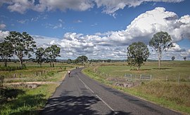
86:Kumbia Road, Brooklands, 2016
186:3.600/km (9.324/sq mi)
51:GPX (secondary coordinates)
1769:
300:Suburbs around Brooklands:
1725:
1197:
1066:(Version 1.01 ed.),
948:Queensland State Archives
358:
298:
294:
91:
79:
46:GPX (primary coordinates)
21:Map all coordinates using
1753:Localities in Queensland
29:Download coordinates as:
1129:2016 Census QuickStats
969:"The Education Report"
885:Queensland Place Names
856:Queensland Place Names
827:Queensland Place Names
798:Queensland Place Names
766:Queensland Place Names
736:2021 Census QuickStats
642:26.74258°S 151.81553°E
569:on native vegetation.
539:"Ngaitu Kuri" meaning
1095:Queensland Government
1037:Queensland Government
889:Queensland Government
860:Queensland Government
831:Queensland Government
802:Queensland Government
770:Queensland Government
41:GPX (all coordinates)
1748:South Burnett Region
1183:South Burnett Region
1001:"Our Nanango Letter"
647:-26.74258; 151.81553
598:26.7111°S 151.8554°E
464:26.7333°S 151.8166°E
383:, Australia. In the
377:South Burnett Region
265:South Burnett Region
147:26.7275°S 151.8294°E
923:State of Queensland
637: /
593: /
562:to the north-east.
552:Bjelke-Petersen Dam
533:Tarong railway line
502: /
459: /
414: /
284:Federal division(s)
272:State electorate(s)
142: /
1602:South East Nanango
1125:"Brooklands (SSC)"
919:"Queensland Globe"
732:"Brooklands (SAL)"
603:-26.7111; 151.8554
507:26.75°S 151.8166°E
469:-26.7333; 151.8166
152:-26.7275; 151.8294
1735:
1734:
1217:Barker Creek Flat
1077:978-1-921171-26-0
419:26.7333°S 151.8°E
366:
365:
362:
361:
1760:
1187:Wide Bay–Burnett
1175:
1168:
1161:
1152:
1145:
1144:
1139:
1137:
1135:
1123:(27 June 2017).
1117:
1111:
1110:
1108:
1106:
1087:
1081:
1080:
1059:
1053:
1052:
1050:
1048:
1029:
1023:
1022:
1020:
1018:
997:
991:
990:
988:
986:
965:
959:
958:
956:
954:
940:
934:
933:
931:
929:
915:
900:
899:
897:
895:
877:
871:
870:
868:
866:
848:
842:
841:
839:
837:
819:
813:
812:
810:
808:
790:
781:
780:
778:
776:
758:
752:
751:
746:
744:
742:
730:(28 June 2022).
724:
661:
660:
658:
657:
656:
654:
649:
648:
643:
638:
635:
634:
633:
630:
617:
616:
614:
613:
612:
610:
605:
604:
599:
594:
591:
590:
589:
586:
526:
525:
523:
522:
521:
519:
514:
513:
512:-26.75; 151.8166
508:
503:
500:
499:
498:
495:
483:
482:
480:
479:
478:
476:
471:
470:
465:
460:
457:
456:
455:
452:
438:
437:
435:
434:
433:
431:
426:
425:
420:
415:
412:
411:
410:
407:
296:
166:
165:
163:
162:
161:
159:
154:
153:
148:
143:
140:
139:
138:
135:
107:
106:
100:
84:
75:
69:
64:
1768:
1767:
1763:
1762:
1761:
1759:
1758:
1757:
1738:
1737:
1736:
1731:
1721:
1532:Mount Mowbullan
1287:Bunya Mountains
1252:Blackbutt South
1247:Blackbutt North
1193:
1179:
1149:
1148:
1133:
1131:
1119:
1118:
1114:
1104:
1102:
1089:
1088:
1084:
1078:
1061:
1060:
1056:
1046:
1044:
1031:
1030:
1026:
1016:
1014:
999:
998:
994:
984:
982:
967:
966:
962:
952:
950:
942:
941:
937:
927:
925:
917:
916:
903:
893:
891:
879:
878:
874:
864:
862:
850:
849:
845:
835:
833:
821:
820:
816:
806:
804:
792:
791:
784:
774:
772:
760:
759:
755:
740:
738:
726:
725:
716:
711:
687:
668:
652:
650:
646:
644:
640:
639:
636:
631:
628:
626:
624:
623:
608:
606:
602:
600:
596:
595:
592:
587:
584:
582:
580:
579:
575:
517:
515:
511:
509:
505:
504:
501:
496:
493:
491:
489:
488:
474:
472:
468:
466:
462:
461:
458:
453:
450:
448:
446:
445:
444:Barkers Creek (
429:
427:
424:-26.7333; 151.8
423:
421:
417:
416:
413:
408:
405:
403:
401:
400:
393:
314:
183: • Density
157:
155:
151:
149:
145:
144:
141:
136:
133:
131:
129:
128:
118:
117:
116:
115:
114:
113:
112:
108:
87:
71:
70:
67:
62:
59:
58:
57:
56:
55:
12:
11:
5:
1766:
1764:
1756:
1755:
1750:
1740:
1739:
1733:
1732:
1727:Main article:
1726:
1723:
1722:
1720:
1719:
1714:
1709:
1704:
1699:
1694:
1689:
1684:
1679:
1674:
1669:
1664:
1659:
1654:
1649:
1644:
1639:
1634:
1629:
1624:
1619:
1614:
1609:
1604:
1599:
1594:
1589:
1584:
1579:
1574:
1569:
1564:
1559:
1554:
1549:
1544:
1539:
1534:
1529:
1524:
1519:
1514:
1509:
1504:
1499:
1494:
1489:
1484:
1479:
1474:
1469:
1464:
1459:
1454:
1449:
1444:
1439:
1434:
1429:
1424:
1419:
1414:
1409:
1404:
1399:
1394:
1389:
1384:
1379:
1377:Ficks Crossing
1374:
1369:
1364:
1359:
1354:
1349:
1344:
1339:
1334:
1329:
1324:
1319:
1314:
1309:
1304:
1299:
1294:
1289:
1284:
1279:
1274:
1269:
1264:
1259:
1254:
1249:
1244:
1239:
1237:Benarkin North
1234:
1229:
1224:
1219:
1214:
1209:
1204:
1198:
1195:
1194:
1180:
1178:
1177:
1170:
1163:
1155:
1147:
1146:
1112:
1082:
1076:
1054:
1024:
992:
960:
935:
901:
872:
843:
814:
782:
753:
713:
712:
710:
707:
686:
683:
667:
664:
574:
571:
529:
528:
487:Middle Creek (
485:
441:
440:
392:
389:
364:
363:
360:
359:
356:
355:
350:
345:
339:
338:
333:
330:
324:
323:
318:
309:
303:
302:
292:
291:
286:
280:
279:
274:
268:
267:
262:
256:
255:
254:
253:
247:
241:
235:
227:
223:
222:
212:
206:
205:
202:
198:
197:
194:
188:
187:
184:
180:
179:
172:
168:
167:
126:
120:
119:
110:
109:
102:
101:
95:
94:
93:
92:
89:
88:
85:
77:
76:
60:
54:
53:
48:
43:
38:
32:
26:
19:
18:
17:
13:
10:
9:
6:
4:
3:
2:
1765:
1754:
1751:
1749:
1746:
1745:
1743:
1730:
1724:
1718:
1715:
1713:
1710:
1708:
1705:
1703:
1700:
1698:
1695:
1693:
1690:
1688:
1685:
1683:
1680:
1678:
1675:
1673:
1670:
1668:
1665:
1663:
1660:
1658:
1655:
1653:
1650:
1648:
1645:
1643:
1640:
1638:
1635:
1633:
1630:
1628:
1625:
1623:
1620:
1618:
1615:
1613:
1610:
1608:
1607:South Nanango
1605:
1603:
1600:
1598:
1595:
1593:
1590:
1588:
1585:
1583:
1580:
1578:
1575:
1573:
1570:
1568:
1565:
1563:
1560:
1558:
1555:
1553:
1550:
1548:
1545:
1543:
1540:
1538:
1535:
1533:
1530:
1528:
1525:
1523:
1520:
1518:
1515:
1513:
1510:
1508:
1505:
1503:
1500:
1498:
1495:
1493:
1490:
1488:
1485:
1483:
1480:
1478:
1475:
1473:
1470:
1468:
1465:
1463:
1460:
1458:
1455:
1453:
1450:
1448:
1445:
1443:
1440:
1438:
1435:
1433:
1430:
1428:
1425:
1423:
1420:
1418:
1415:
1413:
1410:
1408:
1405:
1403:
1400:
1398:
1395:
1393:
1390:
1388:
1385:
1383:
1380:
1378:
1375:
1373:
1370:
1368:
1365:
1363:
1360:
1358:
1355:
1353:
1350:
1348:
1345:
1343:
1340:
1338:
1335:
1333:
1330:
1328:
1325:
1323:
1320:
1318:
1315:
1313:
1310:
1308:
1305:
1303:
1300:
1298:
1295:
1293:
1290:
1288:
1285:
1283:
1280:
1278:
1275:
1273:
1270:
1268:
1265:
1263:
1260:
1258:
1255:
1253:
1250:
1248:
1245:
1243:
1240:
1238:
1235:
1233:
1230:
1228:
1225:
1223:
1220:
1218:
1215:
1213:
1210:
1208:
1205:
1203:
1200:
1199:
1196:
1192:
1188:
1184:
1176:
1171:
1169:
1164:
1162:
1157:
1156:
1153:
1143:
1130:
1126:
1122:
1116:
1113:
1100:
1096:
1092:
1086:
1083:
1079:
1073:
1069:
1065:
1058:
1055:
1042:
1038:
1034:
1028:
1025:
1012:
1008:
1007:
1002:
996:
993:
980:
976:
975:
970:
964:
961:
949:
945:
939:
936:
924:
920:
914:
912:
910:
908:
906:
902:
890:
886:
882:
876:
873:
861:
857:
853:
847:
844:
832:
828:
824:
818:
815:
803:
799:
795:
789:
787:
783:
771:
767:
763:
757:
754:
750:
737:
733:
729:
723:
721:
719:
715:
708:
706:
704:
700:
696:
692:
684:
682:
680:
675:
673:
665:
663:
659:
619:
615:
572:
570:
568:
563:
561:
557:
556:Lake Barambah
553:
548:
546:
542:
538:
537:Kaibara words
534:
524:
486:
481:
475:Barkers Creek
443:
442:
436:
399:Archookoora (
398:
397:
396:
390:
388:
386:
382:
378:
374:
370:
357:
354:
351:
349:
346:
344:
341:
337:
336:South Nanango
334:
331:
329:
326:
322:
319:
317:
313:
310:
308:
305:
301:
293:
290:
287:
285:
281:
278:
275:
273:
269:
266:
263:
261:
257:
252:
248:
246:
242:
240:
236:
234:
230:
229:
228:
224:
220:
216:
213:
211:
207:
203:
199:
195:
193:
189:
185:
181:
177:
173:
169:
164:
127:
125:
121:
99:
90:
83:
78:
74:
65:
52:
49:
47:
44:
42:
39:
37:
34:
33:
31:
30:
25:
24:OpenStreetMap
22:
16:
1672:Wattle Grove
1592:Sandy Ridges
1572:Pimpimbudgee
1527:Mount McEuen
1362:East Nanango
1276:
1132:. Retrieved
1128:
1115:
1103:. Retrieved
1085:
1063:
1057:
1045:. Retrieved
1027:
1015:. Retrieved
1004:
995:
983:. Retrieved
972:
963:
951:. Retrieved
938:
926:. Retrieved
892:. Retrieved
884:
875:
863:. Retrieved
855:
846:
834:. Retrieved
826:
817:
805:. Retrieved
797:
773:. Retrieved
765:
756:
739:. Retrieved
735:
695:Pimpimbudgee
688:
676:
669:
666:Demographics
620:
576:
564:
549:
544:
540:
530:
518:Middle Creek
394:
368:
367:
299:
28:
27:
20:
15:
1677:Wengenville
1667:Wattle Camp
1397:Gordonbrook
1342:Crownthorpe
1302:Charlestown
1207:Alice Creek
741:28 February
679:2021 census
672:2016 census
645: /
632:151°48′56″E
601: /
588:151°51′19″E
510: /
497:151°49′00″E
467: /
454:151°49′00″E
430:Archookoora
422: /
409:151°48′00″E
385:2021 census
371:is a rural
343:Wengenville
192:Postcode(s)
176:2021 census
150: /
137:151°49′46″E
124:Coordinates
1742:Categories
1712:Wooroonden
1692:Wilkesdale
1682:Wheatlands
1637:Tablelands
1627:Sunny Nook
1622:Stonelands
1597:Silverleaf
1522:Moondooner
1512:Moffatdale
1492:Marshlands
1477:Maidenwell
1452:Kinleymore
1412:Hivesville
1407:Haly Creek
1382:Glan Devon
1322:Coolabunia
1317:Cobbs Hill
1307:Chelmsford
1297:Chahpingah
1277:Brooklands
1191:Queensland
1134:20 October
985:14 January
894:15 January
709:References
651: (
629:26°44′33″S
607: (
585:26°42′40″S
560:Moffatdale
554:to create
516: (
494:26°45′00″S
473: (
451:26°44′00″S
428: (
406:26°44′00″S
381:Queensland
369:Brooklands
348:Maidenwell
332:Brooklands
307:Haly Creek
174:324 (
171:Population
156: (
134:26°43′39″S
111:Brooklands
73:Queensland
68:Brooklands
1707:Wooroolin
1617:Stalworth
1612:Speedwell
1587:Runnymede
1502:Memerambi
1437:Kawl Kawl
1432:Johnstown
1417:Hodgleigh
1402:Greenview
1367:Ellesmere
1267:Boyneside
1262:Boondooma
1242:Blackbutt
1202:Abbeywood
685:Education
545:which way
391:Geography
328:Ellesmere
245:Toowoomba
219:UTC+10:00
210:Time zone
1657:Tingoora
1632:Taabinga
1537:Mp Creek
1507:Merlwood
1472:Leafdale
1447:Kingaroy
1442:Keysland
1422:Inverlaw
1387:Glenrock
1372:Fairdale
1337:Crawford
1327:Corndale
1282:Bullcamp
1272:Brigooda
1232:Benarkin
1212:Ballogie
1099:Archived
1097:. 1955.
1041:Archived
1039:. 1943.
1033:"Kumbia"
1011:Archived
979:Archived
703:Kingaroy
373:locality
251:Brisbane
239:Kingaroy
226:Location
1697:Windera
1662:Warnung
1642:Taromeo
1582:Redgate
1577:Proston
1562:Oakdale
1552:Neumgna
1547:Nanango
1517:Mondure
1497:Melrose
1487:Manyung
1482:Mannuem
1467:Kunioon
1427:Ironpot
1392:Goodger
1352:Dangore
1347:Cushnie
1332:Coverty
1093:(Map).
1047:14 July
1035:(Map).
1017:14 July
953:14 July
865:8 March
836:8 March
807:8 March
775:8 March
691:Nanango
677:In the
670:In the
573:History
567:grazing
375:in the
321:Nanango
316:Kunioon
312:Goodger
289:Maranoa
277:Nanango
233:Nanango
1717:Wyalla
1702:Wondai
1687:Wigton
1652:Teelah
1647:Tarong
1567:Okeden
1542:Murgon
1462:Kumbia
1457:Kitoba
1357:Durong
1312:Cloyna
1227:Benair
1222:Barlil
1074:
699:Kumbia
353:Tarong
260:LGA(s)
1557:Nukku
1257:Booie
1105:9 May
928:9 May
1292:Byee
1136:2018
1107:2023
1072:ISBN
1049:2021
1019:2021
987:2018
955:2021
930:2023
896:2021
867:2023
838:2023
809:2023
777:2023
743:2023
541:turn
215:AEST
201:Area
196:4615
662:).
618:).
558:in
543:or
36:KML
1744::
1189:,
1185:,
1127:.
1070:,
1003:.
971:.
946:.
921:.
904:^
887:.
883:.
858:.
854:.
829:.
825:.
800:.
796:.
785:^
768:.
764:.
734:.
717:^
547:.
379:,
1174:e
1167:t
1160:v
1138:.
1109:.
1051:.
957:.
932:.
898:.
869:.
840:.
811:.
779:.
745:.
655:)
622:(
611:)
578:(
527:)
520:)
484:)
477:)
439:)
432:)
221:)
217:(
178:)
160:)
Text is available under the Creative Commons Attribution-ShareAlike License. Additional terms may apply.