36:
254:
The Broad Vein is one of the two major slate veins in Mid Wales that were commercially quarried. Broad Vein rock is generally dense, with few natural joints, so most of the commercial use was for slab and products such as mantlepieces, cisterns and (later) electrical switchboards. Production of
246:
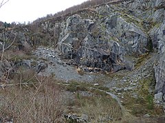
The formation is exposed in a number of locations in Mid Wales where glacial valleys cut across it. It is especially visible in the quarries along its length.
129:
226:
in several locations along its length. The formation is between 400 metres (1,300 ft) and 560 metres (1,840 ft) thick and runs from
437:
35:
447:
415:
452:
442:
75:
122:
385:
356:
222:
in places. It varies in colour from a pale to a medium blue. This formation has been commercially quarried as
279:
278:, the most commercially successful of the quarries that only worked the Broad Vein. Connected to the
275:
203:
57:
41:
311:
293:
315:
85:
411:
296:
which worked from the 14th. century until 2002. Also worked the Narrow Vein. Connected to the
200:
270:
328:
306:
284:
320:
302:
297:
431:
324:
227:
26:
377:
348:
231:
219:
45:
266:
262:
207:
288:
197:
144:
131:
211:
164:
215:
100:
235:
223:
110:
408:
The Slate
Regions of North and Mid Wales and Their Railways
255:
roofing slates was relatively rare in Broad Vein quarries.
305:, which mainly worked the Narrow Vein, connected to the
258:
The Broad Vein was quarried in the following locations:
170:
160:
121:
116:
106:
96:
91:
81:
71:
63:
53:
20:
8:
34:
17:
340:
314:a smaller operation, connected to the
214:. The rock of the formation is silty
7:
269:was also worked, connected to the
14:
382:BGS on-line lexicon of rock units
353:BGS on-line lexicon of rock units
378:"Broad Vein Mudstone Formation"
349:"Broad Vein Mudstone Formation"
76:Narrow Vein Mudstone Formation
1:
182:Broad Vein Mudstone Formation
48:which quarried the Broad Vein
21:Broad Vein Mudstone Formation
406:Richards, Alun John (1999).
188:, historically known as the
438:Ordovician System of Europe
469:
386:British Geological Survey
357:British Geological Survey
33:
25:
448:Rock formations of Wales
453:Slate industry in Wales
443:Upper Ordovician Series
410:. Gwasg Carreg Gwalch.
184:(commonly known as the
280:Upper Corris Tramway
276:Abercwmeiddaw quarry
250:Commercial quarrying
42:Abercwmeiddaw quarry
327:, connected to the
312:Maes-y-gamfa quarry
294:Aberllefenni Quarry
141: /
27:Stratigraphic range
316:Hendre-Ddu Tramway
201:lithostratigraphic
145:52.6632°N 3.8453°W
86:Nod Glas Formation
178:
177:
460:
422:
421:
403:
397:
396:
394:
392:
374:
368:
367:
365:
363:
345:
271:Talyllyn Railway
192:and in Welsh as
156:
155:
153:
152:
151:
150:52.6632; -3.8453
146:
142:
139:
138:
137:
134:
67:Abercorris Group
38:
29:: Hirnantian Age
18:
468:
467:
463:
462:
461:
459:
458:
457:
428:
427:
426:
425:
418:
405:
404:
400:
390:
388:
376:
375:
371:
361:
359:
347:
346:
342:
337:
329:Mawddwy Railway
307:Ratgoed Tramway
285:Cambergi quarry
252:
244:
206:(a sequence of
149:
147:
143:
140:
135:
132:
130:
128:
127:
49:
12:
11:
5:
466:
464:
456:
455:
450:
445:
440:
430:
429:
424:
423:
416:
398:
369:
339:
338:
336:
333:
332:
331:
321:Minllyn quarry
318:
309:
303:Ratgoed quarry
300:
298:Corris Railway
291:
282:
273:
251:
248:
243:
240:
230:south-west to
176:
175:
172:
168:
167:
162:
158:
157:
125:
119:
118:
114:
113:
108:
104:
103:
98:
94:
93:
89:
88:
83:
79:
78:
73:
69:
68:
65:
61:
60:
55:
51:
50:
39:
31:
30:
23:
22:
13:
10:
9:
6:
4:
3:
2:
465:
454:
451:
449:
446:
444:
441:
439:
436:
435:
433:
419:
417:0-86381-552-9
413:
409:
402:
399:
387:
383:
379:
373:
370:
358:
354:
350:
344:
341:
334:
330:
326:
325:Dinas Mawddwy
322:
319:
317:
313:
310:
308:
304:
301:
299:
295:
292:
290:
286:
283:
281:
277:
274:
272:
268:
264:
261:
260:
259:
256:
249:
247:
241:
239:
237:
233:
229:
228:Dinas Mawddwy
225:
221:
217:
213:
209:
205:
202:
199:
195:
191:
187:
183:
173:
169:
166:
163:
159:
154:
126:
124:
120:
115:
112:
109:
105:
102:
99:
95:
90:
87:
84:
80:
77:
74:
70:
66:
62:
59:
56:
52:
47:
43:
37:
32:
28:
24:
19:
16:
407:
401:
391:11 September
389:. Retrieved
381:
372:
360:. Retrieved
352:
343:
257:
253:
245:
232:Cardigan Bay
218:, intensely
193:
189:
185:
181:
179:
46:Corris Uchaf
15:
267:Narrow Vein
263:Bryn Eglwys
220:bioturbated
208:rock strata
194:Y Faen Goch
148: /
123:Coordinates
432:Categories
335:References
289:Cwm Hengae
265:where the
198:Ordovician
186:Broad Vein
133:52°39′48″N
362:6 January
212:Mid Wales
165:Mid Wales
136:3°50′43″W
92:Lithology
72:Underlies
242:Outcrops
216:mudstone
196:) is an
190:Red Vein
117:Location
101:Mudstone
82:Overlies
323:, near
171:Country
97:Primary
64:Unit of
414:
161:Region
236:Tywyn
224:slate
210:) in
204:group
174:Wales
111:Slate
107:Other
58:Group
412:ISBN
393:2019
364:2020
180:The
54:Type
40:The
287:in
234:at
44:in
434::
384:.
380:.
355:.
351:.
238:.
420:.
395:.
366:.
Text is available under the Creative Commons Attribution-ShareAlike License. Additional terms may apply.