91:
693:
58:
41:
98:
65:
357:
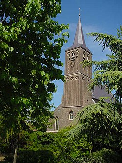
The Holy Name of Jesus Church is a short double-aisled church. Its existence was already recorded in 1214. In the 13th century, the tower was added. It was enlarged in the 15th century. In 1944, the tower was blown up, and the church was rebuilt between 1948 and 1949.
539:
674:
90:
753:
532:
763:
525:
734:
270:
126:
57:
282:
549:
473:
727:
40:
262:
720:
758:
351:
158:
621:
517:
700:
315:
The village was first mentioned in 1294 or 1295 as "apud Vorste", and means "not fenced off forest near
301:
241:
173:
572:
567:
328:
316:
251:
463:
343:
594:
692:
582:
553:
469:
339:
305:
183:
704:
651:
382:
616:
433:
333:
747:
606:
320:
599:
297:
163:
496:
587:
141:
128:
636:
232:
611:
663:
656:
646:
641:
347:
631:
626:
258:
237:
346:. In 1673, it became an independent parish. In 1713, it belonged to
324:
309:
407:
521:
675:
List of cities, towns and villages in
Limburg (Netherlands)
708:
110:
Location in the province of
Limburg in the Netherlands
327:
in the Early Middle Ages. It used to be part of the
560:
281:
269:
248:
231:
223:
215:
210:
202:
194:
189:
179:
169:
157:
21:
462:Sabine Broekhoven, & Ronald Stenvert (2003).
361:Broekhuizenvorst was home to 436 people in 1840.
728:
533:
350:, and finally in 1815, it became part of the
319:". Broekhuizen was added to distinguish from
8:
735:
721:
540:
526:
518:
457:
455:
18:
754:Populated places in Limburg (Netherlands)
434:"Broekhuizenvorst - (geografische naam)"
97:
64:
369:
268:
230:
209:
201:
188:
156:
121:
49:
37:
377:
375:
373:
304:. It is a part of the municipality of
764:Limburg (Netherlands) geography stubs
280:
247:
222:
214:
193:
178:
168:
7:
689:
687:
383:"Kerncijfers wijken en buurten 2021"
323:. Broekhuizenvorst developed on the
198:0.40 km (0.15 sq mi)
707:. You can help Knowledge (XXG) by
14:
342:. In 1648, it became part of the
338:. In 1323, it became part of the
691:
113:Show map of Limburg, Netherlands
96:
89:
63:
56:
39:
414:(in Dutch). Het Waterschapshuis
412:Actueel Hoogtebestand Nederland
16:Village in Limburg, Netherlands
468:(in Dutch). Zwolle: Waanders.
1:
308:and lies 18 km north of
387:Central Bureau of Statistics
227:2,100/km (5,500/sq mi)
77:Location in the Netherlands
780:
686:
352:Kingdom of the Netherlands
672:
408:"Postcodetool for 5871AA"
122:
50:
45:Holy Name of Jesus Church
38:
31:
548:Populated places in the
80:Show map of Netherlands
703:location article is a
206:17 m (56 ft)
250: • Summer (
296:is a village in the
224: • Density
142:51.49417°N 6.15889°E
344:Spanish Netherlands
138: /
497:"Broekhuizenvorst"
216: • Total
195: • Total
759:Horst aan de Maas
716:
715:
681:
680:
554:Horst aan de Maas
340:Duchy of Guelders
306:Horst aan de Maas
291:
290:
184:Horst aan de Maas
147:51.49417; 6.15889
771:
737:
730:
723:
695:
688:
660:
603:
591:
578:Broekhuizenvorst
542:
535:
528:
519:
513:
512:
510:
508:
493:
487:
486:
484:
482:
465:Broekhuizenvorst
459:
450:
449:
447:
445:
430:
424:
423:
421:
419:
404:
398:
397:
395:
393:
379:
337:
294:Broekhuizenvorst
255:
153:
152:
150:
149:
148:
143:
139:
136:
135:
134:
131:
114:
104:Broekhuizenvorst
100:
99:
93:
81:
71:Broekhuizenvorst
67:
66:
60:
43:
23:Broekhuizenvorst
19:
779:
778:
774:
773:
772:
770:
769:
768:
744:
743:
742:
741:
684:
682:
677:
668:
654:
597:
585:
556:
546:
516:
506:
504:
495:
494:
490:
480:
478:
476:
461:
460:
453:
443:
441:
432:
431:
427:
417:
415:
406:
405:
401:
391:
389:
381:
380:
371:
367:
331:
329:Land van Kessel
277:
249:
146:
144:
140:
137:
132:
129:
127:
125:
124:
118:
117:
116:
115:
112:
111:
108:
107:
106:
105:
101:
84:
83:
82:
79:
78:
75:
74:
73:
72:
68:
46:
34:
27:
24:
17:
12:
11:
5:
777:
775:
767:
766:
761:
756:
746:
745:
740:
739:
732:
725:
717:
714:
713:
696:
679:
678:
673:
670:
669:
667:
666:
661:
649:
644:
639:
634:
629:
624:
619:
614:
609:
604:
592:
580:
575:
570:
564:
562:
558:
557:
547:
545:
544:
537:
530:
522:
515:
514:
488:
474:
451:
438:Etymologiebank
425:
399:
368:
366:
363:
289:
288:
285:
279:
278:
275:
273:
267:
266:
256:
246:
245:
235:
229:
228:
225:
221:
220:
217:
213:
212:
208:
207:
204:
200:
199:
196:
192:
191:
187:
186:
181:
177:
176:
171:
167:
166:
161:
155:
154:
120:
119:
109:
103:
102:
95:
94:
88:
87:
86:
85:
76:
70:
69:
62:
61:
55:
54:
53:
52:
51:
48:
47:
44:
36:
35:
32:
29:
28:
25:
22:
15:
13:
10:
9:
6:
4:
3:
2:
776:
765:
762:
760:
757:
755:
752:
751:
749:
738:
733:
731:
726:
724:
719:
718:
712:
710:
706:
702:
701:Dutch Limburg
697:
694:
690:
685:
676:
671:
665:
662:
658:
653:
650:
648:
645:
643:
640:
638:
635:
633:
630:
628:
625:
623:
620:
618:
615:
613:
610:
608:
605:
601:
596:
593:
589:
584:
581:
579:
576:
574:
571:
569:
566:
565:
563:
559:
555:
551:
543:
538:
536:
531:
529:
524:
523:
520:
502:
498:
492:
489:
477:
475:90 400 9623 6
471:
467:
466:
458:
456:
452:
439:
435:
429:
426:
413:
409:
403:
400:
388:
384:
378:
376:
374:
370:
364:
362:
359:
355:
353:
349:
345:
341:
335:
330:
326:
322:
318:
313:
311:
307:
303:
299:
295:
286:
284:
274:
272:
264:
260:
257:
253:
243:
239:
236:
234:
226:
218:
205:
197:
185:
182:
175:
172:
165:
162:
160:
151:
123:Coordinates:
92:
59:
42:
30:
20:
709:expanding it
698:
683:
607:Grubbenvorst
595:Griendtsveen
577:
550:municipality
505:. Retrieved
501:Plaatsengids
500:
491:
479:. Retrieved
464:
442:. Retrieved
437:
428:
416:. Retrieved
411:
402:
390:. Retrieved
386:
360:
356:
321:Grubbenvorst
314:
300:province of
293:
292:
283:Dialing code
180:Municipality
655: [
598: [
586: [
573:Broekhuizen
332: [
317:Broekhuizen
271:Postal code
164:Netherlands
145: /
748:Categories
622:Kronenberg
583:Evertsoord
503:(in Dutch)
440:(in Dutch)
365:References
211:Population
130:51°29′39″N
637:Melderslo
233:Time zone
203:Elevation
612:Hegelsom
561:Villages
507:24 April
481:24 April
444:24 April
418:24 April
392:24 April
170:Province
133:6°9′32″E
664:Tienray
652:Swolgen
647:Sevenum
642:Meterik
568:America
348:Prussia
302:Limburg
174:Limburg
159:Country
33:Village
632:Meerlo
627:Lottum
472:
699:This
659:]
617:Horst
602:]
590:]
336:]
310:Venlo
298:Dutch
259:UTC+2
238:UTC+1
705:stub
509:2022
483:2022
470:ISBN
446:2022
420:2022
394:2022
325:Maas
276:5871
263:CEST
190:Area
26:Vors
552:of
287:077
252:DST
242:CET
219:850
750::
657:nl
600:nl
588:nl
499:.
454:^
436:.
410:.
385:.
372:^
354:.
334:nl
312:.
736:e
729:t
722:v
711:.
541:e
534:t
527:v
511:.
485:.
448:.
422:.
396:.
265:)
261:(
254:)
244:)
240:(
Text is available under the Creative Commons Attribution-ShareAlike License. Additional terms may apply.