49:
199:
in the 16th century. Some of Royall's land was later transferred to Moses Brown, a farmer in whose family it remained for over three hundred years. The Browns' farmland was sold off in 1977, creating the Brown's Point Road development.
48:
62:
237:
301:
346:
147:
206:
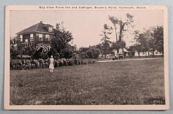
The 100-acre (40-hectare) Bay View Farm Inn and
Cottages stood on the point in the early 20th century. It burned down in 2008.
116:
196:
121:
94:
17:
180:, United States. It is located around 1.90 miles (3.06 km) east of Yarmouth Village at the confluence of
21:
316:
157:
188:, to the south. It sits across Cousins River from Powell Point and across Royal River from
177:
131:
203:
Mary
Estelle Blake (1920–2017) was the last of the Brown family to live on the point.
340:
181:
189:
185:
104:
77:
64:
138:
271:
Modern Maine: Its
Historic Background, People, and Resources · Volume 2
164:
143:
109:
317:"Tribute Archive Obituary - Visitation & Funeral Information"
53:
The now-destroyed Bay View Farm Inn and
Cottages, c. 1930
16:
For the census designated place in
Washington State, see
258:. U.S. Government Printing Office. 1884. p. 162.
273:. Lewis Historical Publishing Company. p. 249.
154:
137:
127:
115:
103:
93:
32:
195:The land was originally owned by English settler
244:. U.S. Government Printing Office. p. 465.
226:. University of Maine Press. 1973. p. 117.
20:. For the headland in Lancashire, England, see
192:. The point is accessible via Bayview Street.
8:
306:, Spring 2016, Yarmouth Historical Society
29:
238:United States Coast and Geodetic Survey
215:
136:
92:
45:
303:The Yarmouth History Center Newsletter
282:
280:
153:
126:
114:
102:
7:
297:
295:
27:Promontory in Maine, United States
14:
78:43.79521028921°N 70.1500405138°W
47:
289:, Hall, Alan M., Arcadia (2002)
224:The University of Maine Studies
83:43.79521028921; -70.1500405138
1:
256:Annual Report of the Director
347:Landforms of Yarmouth, Maine
287:Images of America: Yarmouth
269:Hebert, Richard E. (1951).
363:
242:Atlantic Local Coast Pilot
15:
58:
46:
39:
18:Browns Point, Washington
321:www.tributearchive.com
156: • Summer (
184:, to the north, and
176:is a promontory in
74: /
22:Jenny Brown's Point
171:
170:
354:
331:
330:
328:
327:
313:
307:
299:
290:
284:
275:
274:
266:
260:
259:
252:
246:
245:
234:
228:
227:
220:
161:
89:
88:
86:
85:
84:
79:
75:
72:
71:
70:
67:
51:
30:
362:
361:
357:
356:
355:
353:
352:
351:
337:
336:
335:
334:
325:
323:
315:
314:
310:
300:
293:
285:
278:
268:
267:
263:
254:
253:
249:
236:
235:
231:
222:
221:
217:
212:
178:Yarmouth, Maine
155:
82:
80:
76:
73:
68:
65:
63:
61:
60:
54:
42:
35:
28:
25:
12:
11:
5:
360:
358:
350:
349:
339:
338:
333:
332:
308:
291:
276:
261:
247:
229:
214:
213:
211:
208:
197:William Royall
169:
168:
162:
152:
151:
141:
135:
134:
129:
125:
124:
119:
113:
112:
107:
101:
100:
97:
91:
90:
56:
55:
52:
44:
43:
40:
37:
36:
33:
26:
13:
10:
9:
6:
4:
3:
2:
359:
348:
345:
344:
342:
322:
318:
312:
309:
305:
304:
298:
296:
292:
288:
283:
281:
277:
272:
265:
262:
257:
251:
248:
243:
239:
233:
230:
225:
219:
216:
209:
207:
204:
201:
198:
193:
191:
187:
183:
182:Cousins River
179:
175:
174:Brown's Point
166:
163:
159:
149:
148:Eastern (EST)
145:
142:
140:
133:
130:
123:
120:
118:
111:
108:
106:
99:United States
98:
96:
87:
59:Coordinates:
57:
50:
38:
34:Brown's Point
31:
23:
19:
324:. Retrieved
320:
311:
302:
286:
270:
264:
255:
250:
241:
232:
223:
218:
205:
202:
194:
190:Callen Point
173:
172:
186:Royal River
81: /
326:2023-03-28
210:References
122:Cumberland
69:70°09′00″W
66:43°47′43″N
41:Promontory
139:Time zone
341:Category
240:(1879).
132:Yarmouth
95:Country
117:County
167:(EDT)
165:UTC-4
144:UTC-5
110:Maine
105:State
128:Town
158:DST
343::
319:.
294:^
279:^
329:.
160:)
150:)
146:(
24:.
Text is available under the Creative Commons Attribution-ShareAlike License. Additional terms may apply.