343:. No motorized vehicles are allowed on the dunes but climbing and sledding are permitted. There are seven-mile (11 km) and nine-mile (14 km) horseback riding trails around the dunes. An educational center offers natural history displays and a gift shop. The astronomical observatory is open Friday and Saturday evenings mid-March through mid-October. Two cabins, 82 RV sites (with water/electricity) and 32 standard sites are available year round in two campgrounds: Eagle Cove Campground and Broken Wheel Campground. An equestrian overnight facility, with corrals, is also available. Fishing for bass and bluegill is popular in the park's small lake. Only non-motorized canoes, rafts and float tubes are allowed.
86:
55:
38:
93:
62:
355:
280:'s tallest single-structured sand dune, which is approximately 470 feet (140 m) in height. The park encompasses 4,800 acres (7.5 sq mi; 19 km) and features the Bruneau Dunes Observatory, where visitors can use a
305:: where others in the Americas form at the edge of a natural basin, the Bruneau dunes form near the center. The basin has acted as a natural trap for over 12,000 years. The dunes may have started with sands from the
309:
about 15,000 years ago. With prevailing winds blowing from the southeast 28 percent of the time and from the northwest 32 percent of the time, the dunes stay fairly stable, and unlike most dunes, do not drift far.
850:
326:
Land for the park was purchased under the
Recreation and Public Purposes Act in May 1967. Additional acreage was acquired in 1980 and in 1984, bringing the park's total area to 4,800 acres (19 km).
1274:
534:
878:
650:
571:
1471:
1299:
883:
1476:
85:
938:
54:
601:
393:
1481:
1324:
1254:
893:
1434:
1359:
1289:
1259:
218:
149:
1304:
1284:
1269:
1249:
1237:
860:
832:
592:
873:
1364:
1339:
948:
655:
619:
564:
903:
1369:
1061:
956:
779:
318:
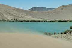
The state park includes desert, dune, prairie, lake and marsh habitat. Desert wildlife is prominent along with birds of prey and waterfowl.
1334:
1294:
1264:
580:
738:
683:
1461:
1389:
1384:
1349:
1319:
1309:
1279:
1122:
817:
723:
1404:
1394:
1379:
1172:
812:
802:
632:
898:
743:
1399:
1374:
1354:
1329:
1314:
827:
822:
784:
642:
557:
933:
1344:
1217:
698:
693:
478:
1132:
665:
627:
1422:
1117:
807:
27:
1222:
1466:
908:
1036:
986:
1102:
981:
976:
913:
1212:
1142:
1227:
868:
842:
688:
673:
1182:
1094:
761:
713:
609:
368:
200:
1006:
1456:
1051:
794:
771:
728:
708:
1167:
1162:
1112:
1026:
1021:
971:
918:
733:
718:
703:
373:
1202:
1192:
1152:
996:
888:
1031:
1207:
1177:
1147:
923:
678:
544:
240:
1071:
1197:
1187:
1046:
262:
247:
137:
119:
1137:
1127:
928:
499:
455:
1157:
753:
302:
251:
991:
285:
306:
528:
430:
228:
1041:
961:
339:, fishing, birdwatching, camping, hiking, swimming, and viewing the stars at the public
1001:
540:
258:
1450:
966:
277:
243:
127:
70:
1056:
1016:
1011:
360:
336:
37:
1066:
340:
350:
273:
164:
151:
281:
549:
397:
1085:
584:
254:
123:
101:
269:
553:
239:
is a public recreation and geologic preservation area in the
392:
The highest multistructured dune in North
America is at
1417:
1236:
1093:
1084:
947:
859:
841:
793:
770:
752:
664:
641:
618:
600:
591:
224:
214:
206:
196:
188:
180:
143:
133:
115:
20:
485:. (Lewiston, Idaho). Associated Press. p. 3F.
400:and is approximately 750 feet (230 m) high.
92:
61:
620:National Historic Sites & Historical Parks
565:
425:
423:
421:
419:
417:
219:Idaho Department of Parks and Recreation
8:
394:Great Sand Dunes National Park and Preserve
1090:
597:
572:
558:
550:
17:
450:
448:
1435:Idaho Department of Parks and Recreation
261:and fifteen miles (25 km) south of
1472:Protected areas of Owyhee County, Idaho
851:Morley Nelson Snake River Birds of Prey
833:Oxford Slough Waterfowl Production Area
494:
492:
479:"Idaho has America's tallest sand dune"
413:
385:
477:Gallagher, Susan (September 8, 1985).
7:
114:
1477:Protected areas established in 1967
301:The park's dunes are unique in the
14:
1482:Landforms of Owyhee County, Idaho
506:. Idaho Museum of Natural History
458:. Idaho Museum of Natural History
353:
91:
84:
60:
53:
36:
30:V (protected landscape/seascape)
949:National Wild and Scenic Rivers
884:Frank Church–River of No Return
456:"History: State Lands in Idaho"
205:
132:
1423:Central Idaho Dark Sky Reserve
1275:Camas Prairie Centennial Marsh
1:
75:Show map of the United States
939:Cecil D. Andrus–White Clouds
535:Bruneau Dunes State Park Map
433:. Idaho Parks and Recreation
1223:Trail of the Coeur d'Alenes
843:National Conservation Areas
42:Bruneau sand dunes and lake
1498:
1462:Dunes of the United States
537:Idaho Parks and Recreation
531:Idaho Parks and Recreation
431:"Bruneau Dunes State Park"
257:. It is northeast of
192:2,470 ft (750 m)
1429:
795:National Wildlife Refuges
772:National Recreation Areas
369:List of Idaho state parks
47:
35:
25:
977:Clearwater (Middle Fork)
541:Bruneau Dunes State Park
529:Bruneau Dunes State Park
237:Bruneau Dunes State Park
229:Bruneau Dunes State Park
184:4,800 acres (19 km)
21:Bruneau Dunes State Park
1173:Land of the Yankee Fork
874:Bruneau–Jarbidge Rivers
374:National Parks in Idaho
904:Jim McClure–Jerry Peak
504:Digital Atlas of Idaho
1218:Three Island Crossing
1123:Coeur d'Alene Parkway
545:DarkSky International
272:and small lakes, the
268:Featuring large sand
1467:State parks of Idaho
1052:Salmon (Middle Fork)
656:Hagerman Fossil Beds
500:"Bruneau Sand Dunes"
138:Mountain Home, Idaho
1300:Coeur d'Alene River
1027:Owyhee (South Fork)
1022:Owyhee (North Fork)
972:Bruneau (West Fork)
879:Craters of the Moon
754:National Grasslands
651:Craters of the Moon
335:Activities include
165:42.91°N 115.70972°W
161: /
1007:Little Jacks Creek
909:Little Jacks Creek
899:Hemingway–Boulders
643:National Monuments
303:Western Hemisphere
1444:
1443:
1413:
1412:
1325:Georgetown Summit
1255:Billingsley Creek
1080:
1079:
992:Dickshooter Creek
934:Selway–Bitterroot
914:North Fork Owyhee
543:at a database of
234:
233:
170:42.91; -115.70972
134:Nearest city
106:Show map of Idaho
1489:
1213:Thousand Springs
1091:
1072:Wickahoney Creek
982:Cottonwood Creek
861:Wilderness Areas
666:National Forests
598:
574:
567:
560:
551:
516:
515:
513:
511:
496:
487:
486:
474:
468:
467:
465:
463:
452:
443:
442:
440:
438:
427:
401:
390:
363:
358:
357:
356:
307:Bonneville Flood
201:Idaho state park
176:
175:
173:
172:
171:
166:
162:
159:
158:
157:
154:
107:
95:
94:
88:
76:
69:Location in the
64:
63:
57:
40:
18:
1497:
1496:
1492:
1491:
1490:
1488:
1487:
1486:
1457:IUCN Category V
1447:
1446:
1445:
1440:
1425:
1409:
1360:Niagara Springs
1290:Cecil D. Andrus
1260:Blackfoot River
1241:
1239:
1232:
1228:Winchester Lake
1076:
962:Big Jacks Creek
943:
869:Big Jacks Creek
855:
837:
789:
766:
748:
739:Wallowa–Whitman
699:Idaho Panhandle
684:Caribou-Targhee
660:
637:
614:
587:
581:Protected areas
578:
525:
520:
519:
509:
507:
498:
497:
490:
476:
475:
471:
461:
459:
454:
453:
446:
436:
434:
429:
428:
415:
410:
405:
404:
391:
387:
382:
359:
354:
352:
349:
333:
324:
314:Flora and fauna
294:
292:Natural history
276:is the site of
169:
167:
163:
160:
155:
152:
150:
148:
147:
111:
110:
109:
108:
105:
104:
98:
97:
96:
79:
78:
77:
74:
73:
67:
66:
65:
43:
31:
12:
11:
5:
1495:
1493:
1485:
1484:
1479:
1474:
1469:
1464:
1459:
1449:
1448:
1442:
1441:
1439:
1438:
1430:
1427:
1426:
1421:
1419:
1415:
1414:
1411:
1410:
1408:
1407:
1402:
1397:
1392:
1387:
1382:
1377:
1372:
1367:
1362:
1357:
1352:
1347:
1342:
1337:
1332:
1327:
1322:
1317:
1312:
1307:
1305:Craig Mountain
1302:
1297:
1292:
1287:
1285:Cartier Slough
1282:
1277:
1272:
1270:Boundary Creek
1267:
1262:
1257:
1252:
1250:Big Cottonwood
1246:
1244:
1234:
1233:
1231:
1230:
1225:
1220:
1215:
1210:
1205:
1200:
1195:
1190:
1185:
1183:Massacre Rocks
1180:
1175:
1170:
1165:
1160:
1155:
1150:
1145:
1140:
1135:
1130:
1125:
1120:
1115:
1110:
1105:
1099:
1097:
1088:
1082:
1081:
1078:
1077:
1075:
1074:
1069:
1064:
1059:
1054:
1049:
1044:
1039:
1034:
1029:
1024:
1019:
1014:
1009:
1004:
999:
994:
989:
984:
979:
974:
969:
964:
959:
953:
951:
945:
944:
942:
941:
936:
931:
926:
921:
916:
911:
906:
901:
896:
891:
886:
881:
876:
871:
865:
863:
857:
856:
854:
853:
847:
845:
839:
838:
836:
835:
830:
825:
820:
815:
810:
805:
799:
797:
791:
790:
788:
787:
782:
776:
774:
768:
767:
765:
764:
758:
756:
750:
749:
747:
746:
741:
736:
731:
726:
724:Salmon-Challis
721:
716:
711:
706:
701:
696:
691:
686:
681:
676:
670:
668:
662:
661:
659:
658:
653:
647:
645:
639:
638:
636:
635:
630:
624:
622:
616:
615:
613:
612:
606:
604:
602:National Parks
595:
589:
588:
579:
577:
576:
569:
562:
554:
548:
547:
538:
532:
524:
523:External links
521:
518:
517:
488:
483:Sunday Tribune
469:
444:
412:
411:
409:
406:
403:
402:
384:
383:
381:
378:
377:
376:
371:
365:
364:
348:
345:
332:
329:
323:
320:
316:
315:
299:
298:
293:
290:
232:
231:
226:
222:
221:
216:
212:
211:
208:
204:
203:
198:
194:
193:
190:
186:
185:
182:
178:
177:
145:
141:
140:
135:
131:
130:
117:
113:
112:
99:
90:
89:
83:
82:
81:
80:
68:
59:
58:
52:
51:
50:
49:
48:
45:
44:
41:
33:
32:
26:
23:
22:
13:
10:
9:
6:
4:
3:
2:
1494:
1483:
1480:
1478:
1475:
1473:
1470:
1468:
1465:
1463:
1460:
1458:
1455:
1454:
1452:
1437:
1436:
1432:
1431:
1428:
1424:
1420:
1416:
1406:
1403:
1401:
1398:
1396:
1393:
1391:
1388:
1386:
1383:
1381:
1378:
1376:
1373:
1371:
1368:
1366:
1365:Payette River
1363:
1361:
1358:
1356:
1353:
1351:
1348:
1346:
1343:
1341:
1340:McArthur Lake
1338:
1336:
1333:
1331:
1328:
1326:
1323:
1321:
1318:
1316:
1313:
1311:
1308:
1306:
1303:
1301:
1298:
1296:
1293:
1291:
1288:
1286:
1283:
1281:
1278:
1276:
1273:
1271:
1268:
1266:
1263:
1261:
1258:
1256:
1253:
1251:
1248:
1247:
1245:
1243:
1235:
1229:
1226:
1224:
1221:
1219:
1216:
1214:
1211:
1209:
1206:
1204:
1201:
1199:
1196:
1194:
1191:
1189:
1186:
1184:
1181:
1179:
1176:
1174:
1171:
1169:
1166:
1164:
1161:
1159:
1156:
1154:
1151:
1149:
1146:
1144:
1141:
1139:
1136:
1134:
1131:
1129:
1126:
1124:
1121:
1119:
1118:City of Rocks
1116:
1114:
1111:
1109:
1108:Bruneau Dunes
1106:
1104:
1101:
1100:
1098:
1096:
1092:
1089:
1087:
1083:
1073:
1070:
1068:
1065:
1063:
1060:
1058:
1055:
1053:
1050:
1048:
1045:
1043:
1040:
1038:
1035:
1033:
1030:
1028:
1025:
1023:
1020:
1018:
1015:
1013:
1010:
1008:
1005:
1003:
1000:
998:
995:
993:
990:
988:
985:
983:
980:
978:
975:
973:
970:
968:
965:
963:
960:
958:
955:
954:
952:
950:
946:
940:
937:
935:
932:
930:
927:
925:
922:
920:
917:
915:
912:
910:
907:
905:
902:
900:
897:
895:
892:
890:
887:
885:
882:
880:
877:
875:
872:
870:
867:
866:
864:
862:
858:
852:
849:
848:
846:
844:
840:
834:
831:
829:
826:
824:
821:
819:
816:
814:
811:
809:
806:
804:
801:
800:
798:
796:
792:
786:
783:
781:
778:
777:
775:
773:
769:
763:
760:
759:
757:
755:
751:
745:
744:Wasatch-Cache
742:
740:
737:
735:
732:
730:
727:
725:
722:
720:
717:
715:
712:
710:
707:
705:
702:
700:
697:
695:
694:Coeur d'Alene
692:
690:
687:
685:
682:
680:
677:
675:
672:
671:
669:
667:
663:
657:
654:
652:
649:
648:
646:
644:
640:
634:
633:Nez Perce NHP
631:
629:
626:
625:
623:
621:
617:
611:
608:
607:
605:
603:
599:
596:
594:
590:
586:
582:
575:
570:
568:
563:
561:
556:
555:
552:
546:
542:
539:
536:
533:
530:
527:
526:
522:
505:
501:
495:
493:
489:
484:
480:
473:
470:
457:
451:
449:
445:
432:
426:
424:
422:
420:
418:
414:
407:
399:
395:
389:
386:
379:
375:
372:
370:
367:
366:
362:
351:
346:
344:
342:
338:
330:
328:
321:
319:
313:
312:
311:
308:
304:
296:
295:
291:
289:
287:
283:
279:
278:North America
275:
271:
266:
264:
263:Mountain Home
260:
256:
253:
249:
248:Owyhee County
246:, located in
245:
244:United States
242:
238:
230:
227:
223:
220:
217:
215:Administrator
213:
209:
202:
199:
195:
191:
187:
183:
179:
174:
146:
142:
139:
136:
129:
125:
121:
120:Owyhee County
118:
103:
87:
72:
71:United States
56:
46:
39:
34:
29:
28:IUCN category
24:
19:
16:
1433:
1370:Pend Oreille
1168:Lake Walcott
1163:Lake Cascade
1133:Eagle Island
1113:Castle Rocks
1107:
997:Duncan Creek
957:Battle Creek
919:Owyhee River
894:Hells Canyon
780:Hells Canyon
628:Minidoka NHS
508:. Retrieved
503:
482:
472:
460:. Retrieved
435:. Retrieved
388:
361:Idaho portal
337:sandboarding
334:
325:
322:Park history
317:
300:
267:
252:southwestern
236:
235:
100:Location in
15:
1335:Market Lake
1295:C.J. Strike
1265:Boise River
1203:Priest Lake
1193:Old Mission
1153:Henrys Lake
1095:State Parks
1062:Sheep Creek
889:Gospel Hump
610:Yellowstone
437:October 18,
341:observatory
207:Established
197:Designation
168: /
156:115°42′35″W
144:Coordinates
1451:Categories
1390:Sand Creek
1385:St. Maries
1350:Montpelier
1320:Fort Boise
1310:Deer Parks
1280:Carey Lake
1240:Management
1208:Round Lake
1178:Lucky Peak
1148:Hells Gate
1037:Red Canyon
987:Deep Creek
924:Pole Creek
818:Grays Lake
689:Clearwater
674:Bitterroot
408:References
331:Recreation
286:stargazing
274:state park
153:42°54′36″N
1405:Tex Creek
1395:Snow Peak
1380:Red River
1198:Ponderosa
1188:McCroskey
1103:Bear Lake
1042:Saint Joe
813:Deer Flat
803:Bear Lake
714:Nez Perce
282:telescope
189:Elevation
1400:Sterling
1375:Portneuf
1355:Mud Lake
1330:Hagerman
1315:Farragut
1238:Wildlife
1143:Harriman
1138:Farragut
1128:Dworshak
1002:Jarbidge
929:Sawtooth
828:Minidoka
823:Kootenai
785:Sawtooth
729:Sawtooth
709:Kootenai
510:March 4,
462:March 4,
398:Colorado
347:See also
116:Location
1345:Montour
1158:Heyburn
967:Bruneau
734:St. Joe
719:Payette
704:Kaniksu
593:Federal
297:Geology
259:Bruneau
241:western
225:Website
1057:Selway
1047:Salmon
1017:Owyhee
1012:Lochsa
762:Curlew
1418:Other
1242:Areas
1086:State
1067:Snake
1032:Rapid
808:Camas
679:Boise
585:Idaho
380:Notes
270:dunes
255:Idaho
124:Idaho
102:Idaho
512:2011
464:2011
439:2017
284:for
210:1967
181:Area
128:U.S.
583:of
396:in
250:in
1453::
502:.
491:^
481:.
447:^
416:^
288:.
265:.
126:,
122:,
573:e
566:t
559:v
514:.
466:.
441:.
Text is available under the Creative Commons Attribution-ShareAlike License. Additional terms may apply.