49:
33:
983:
56:
210:
A 30-kilometre (19 mi) roadway connecting the Muara and
Temburong districts of Brunei, completed in 2018, crosses over the Brunei bay. The section going across the Brunei bay measures in at 14-kilometre (8.7 mi).
360:
Caldecott (1987); Currie (1979a, 1979b, 1980 & 1982); Farmer (1986); Farmer et al. (1986); Howes & Sahat (in prep); Karpowicz (1985); Lindley (1982); Sahat (1987); Teng (1970 & 1971); UGL Consultants Ltd
48:
389:
305:
1024:
1111:
1101:
1106:
1096:
95:
1037:
382:
1116:
1086:
1017:
902:
1091:
701:
521:
375:
777:
1081:
654:
529:
309:
1010:
511:
1076:
535:
248:
595:
240:
477:
925:
662:
284:
690:
331:
247:(IBA) because it supports significant numbers of the populations of various bird species, including
865:
845:
244:
193:
812:
472:
452:
850:
797:
792:
615:
610:
585:
555:
268:
264:
200:
137:
493:
467:
462:
447:
422:
32:
994:
958:
892:
739:
503:
256:
948:
943:
920:
719:
667:
605:
600:
252:
144:
910:
860:
767:
754:
744:
724:
633:
590:
550:
488:
173:
151:
81:
1070:
802:
762:
729:
565:
260:
127:
953:
870:
855:
827:
545:
272:
982:
915:
822:
817:
807:
734:
714:
540:
442:
709:
672:
560:
457:
437:
367:
228:
1052:
1039:
110:
97:
935:
837:
577:
483:
432:
280:
236:
276:
232:
224:
189:
161:
220:
204:
138:
990:
884:
625:
185:
181:
157:
399:
682:
371:
414:
203:
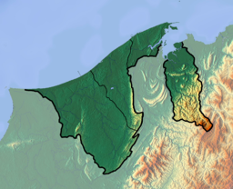
of Brunei, separated from the rest of Brunei by the
Malaysian
364:
John R. Howes, Mohammad Jaya bin Haji Sahat and Euan G. Ross.
998:
934:
901:
883:
836:
785:
776:
753:
700:
681:
653:
646:
624:
576:
520:
502:
413:
406:
150:
136:
126:
87:
77:
21:
219:Brunei Bay contains some 8,000 hectares of tidal
88:
55:
1018:
383:
8:
1025:
1011:
782:
650:
410:
390:
376:
368:
18:
199:It is the ocean gateway to the isolated
296:
239:islets. These have been identified by
16:Bay on the north-west coast of Borneo
7:
979:
977:
997:. You can help Knowledge (XXG) by
180:) is on the northwestern coast of
14:
981:
54:
47:
31:
1112:Important Bird Areas of Sarawak
304:Rabiatul, Kamit (10 May 2013).
1102:Important Bird Areas of Brunei
308:. Brunei Times. Archived from
1:
1107:Important Bird Areas of Sabah
306:"Temburong bridge ready 2018"
76:
287:through mangrove clearance.
647:Interior and water features
207:surrounding it to the bay.
1133:
976:
275:. Threats include inshore
111:5.0120667°N 115.2907389°E
42:
30:
338:. BirdLife International
192:. It is located east of
1117:Brunei geography stubs
1097:Brunei–Malaysia border
993:location article is a
398:Physical geography of
241:BirdLife International
177:
116:5.0120667; 115.2907389
285:habitat fragmentation
249:Bonaparte's nightjars
37:Brunei Bay from space
1087:Landforms of Sarawak
1049: /
269:spotted greenshanks
265:greater sandplovers
245:Important Bird Area
235:, beach forest and
194:Bandar Seri Begawan
107: /
1092:Temburong District
336:BirdLife Data Zone
201:Temburong District
1053:5.083°N 115.300°E
1006:
1005:
971:
970:
967:
966:
879:
878:
693:(Bukit Tengkorak)
642:
641:
167:
166:
1124:
1082:Bays of Malaysia
1064:
1063:
1061:
1060:
1059:
1054:
1050:
1047:
1046:
1045:
1042:
1027:
1020:
1013:
985:
978:
783:
651:
411:
407:Coastal features
392:
385:
378:
369:
348:
347:
345:
343:
328:
322:
321:
319:
317:
301:
253:lesser adjutants
140:
122:
121:
119:
118:
117:
112:
108:
105:
104:
103:
100:
90:
58:
57:
51:
35:
19:
1132:
1131:
1127:
1126:
1125:
1123:
1122:
1121:
1067:
1066:
1057:
1055:
1051:
1048:
1043:
1040:
1038:
1036:
1035:
1034:
1032:
1031:
974:
972:
963:
930:
903:Volcanic fields
897:
875:
832:
772:
755:Mountain ranges
749:
696:
677:
663:Agop Batu Tulug
638:
620:
572:
536:Spratly Islands
530:List of islands
516:
498:
402:
396:
357:
352:
351:
341:
339:
330:
329:
325:
315:
313:
303:
302:
298:
293:
223:and sandflats,
217:
154: countries
145:South China Sea
139:Primary inflows
115:
113:
109:
106:
101:
98:
96:
94:
93:
73:
72:
71:
70:
69:
68:
67:
63:
59:
38:
23:
17:
12:
11:
5:
1130:
1128:
1120:
1119:
1114:
1109:
1104:
1099:
1094:
1089:
1084:
1079:
1077:Bays of Brunei
1069:
1068:
1058:5.083; 115.300
1030:
1029:
1022:
1015:
1007:
1004:
1003:
986:
969:
968:
965:
964:
962:
961:
956:
951:
946:
940:
938:
932:
931:
929:
928:
923:
918:
913:
907:
905:
899:
898:
896:
895:
889:
887:
881:
880:
877:
876:
874:
873:
868:
863:
858:
853:
848:
842:
840:
834:
833:
831:
830:
825:
820:
815:
810:
805:
800:
795:
789:
787:
780:
774:
773:
771:
770:
765:
759:
757:
751:
750:
748:
747:
742:
737:
732:
727:
722:
717:
712:
706:
704:
698:
697:
695:
694:
687:
685:
679:
678:
676:
675:
670:
665:
659:
657:
648:
644:
643:
640:
639:
637:
636:
630:
628:
622:
621:
619:
618:
613:
608:
603:
598:
593:
588:
582:
580:
574:
573:
571:
570:
569:
568:
563:
558:
553:
548:
543:
532:
526:
524:
518:
517:
515:
514:
508:
506:
500:
499:
497:
496:
491:
486:
481:
475:
470:
465:
460:
455:
450:
445:
440:
435:
430:
425:
419:
417:
408:
404:
403:
397:
395:
394:
387:
380:
372:
366:
365:
362:
356:
353:
350:
349:
323:
295:
294:
292:
289:
261:Chinese egrets
257:Storm's storks
216:
213:
165:
164:
155:
148:
147:
142:
134:
133:
130:
124:
123:
102:115°17′26.66″E
91:
85:
84:
82:Southeast Asia
79:
75:
74:
61:
60:
53:
52:
46:
45:
44:
43:
40:
39:
36:
28:
27:
15:
13:
10:
9:
6:
4:
3:
2:
1129:
1118:
1115:
1113:
1110:
1108:
1105:
1103:
1100:
1098:
1095:
1093:
1090:
1088:
1085:
1083:
1080:
1078:
1075:
1074:
1072:
1065:
1062:
1028:
1023:
1021:
1016:
1014:
1009:
1008:
1002:
1000:
996:
992:
987:
984:
980:
975:
960:
957:
955:
952:
950:
947:
945:
942:
941:
939:
937:
933:
927:
924:
922:
919:
917:
914:
912:
909:
908:
906:
904:
900:
894:
891:
890:
888:
886:
882:
872:
869:
867:
864:
862:
859:
857:
854:
852:
849:
847:
844:
843:
841:
839:
835:
829:
826:
824:
821:
819:
816:
814:
811:
809:
806:
804:
801:
799:
796:
794:
791:
790:
788:
784:
781:
779:
775:
769:
766:
764:
761:
760:
758:
756:
752:
746:
743:
741:
738:
736:
733:
731:
728:
726:
723:
721:
718:
716:
713:
711:
708:
707:
705:
703:
699:
692:
689:
688:
686:
684:
680:
674:
671:
669:
666:
664:
661:
660:
658:
656:
652:
649:
645:
635:
632:
631:
629:
627:
623:
617:
614:
612:
609:
607:
604:
602:
599:
597:
594:
592:
589:
587:
584:
583:
581:
579:
575:
567:
564:
562:
559:
557:
554:
552:
549:
547:
546:Layang Layang
544:
542:
539:
538:
537:
533:
531:
528:
527:
525:
523:
519:
513:
512:Tip of Borneo
510:
509:
507:
505:
501:
495:
492:
490:
487:
485:
482:
480:(Pasir Putih)
479:
476:
474:
471:
469:
466:
464:
461:
459:
456:
454:
451:
449:
446:
444:
441:
439:
436:
434:
431:
429:
426:
424:
421:
420:
418:
416:
412:
409:
405:
401:
393:
388:
386:
381:
379:
374:
373:
370:
363:
359:
358:
355:Other sources
354:
337:
333:
327:
324:
312:on 2013-12-03
311:
307:
300:
297:
290:
288:
286:
283:hunting, and
282:
278:
274:
273:roseate terns
270:
266:
262:
258:
254:
250:
246:
242:
238:
234:
230:
226:
222:
214:
212:
208:
206:
205:Sarawak State
202:
197:
195:
191:
187:
183:
179:
175:
171:
163:
159:
156:
153:
149:
146:
143:
141:
135:
131:
129:
125:
120:
92:
86:
83:
80:
66:
50:
41:
34:
29:
26:
20:
1033:
999:expanding it
988:
973:
798:Kinabatangan
427:
340:. Retrieved
335:
332:"Brunei Bay"
326:
314:. Retrieved
310:the original
299:
218:
209:
198:
178:Teluk Brunei
169:
168:
99:5°00′43.44″N
65:Teluk Brunei
64:
25:Teluk Brunei
24:
1056: /
838:Tributaries
786:Main rivers
229:coral reefs
215:Environment
184:island, in
114: /
89:Coordinates
62:Brunei Bay
22:Brunei Bay
1071:Categories
959:Takob Akob
936:Waterfalls
740:Tambuyukon
596:Karambunai
578:Peninsulas
489:Schomburgk
291:References
196:, Brunei.
170:Brunei Bay
944:Kadamaian
921:Magdalena
893:Kundasang
720:Kaingaran
702:Mountains
668:Gomantong
551:Mantanani
534:disputed
484:Sepanggar
342:3 October
281:waterbird
237:sandstone
233:mangroves
1044:115°18′E
911:Bombalai
861:Pandasan
768:Trusmadi
745:Trusmadi
725:Kinabalu
616:Semporna
611:Sandakan
586:Bengkoka
556:Peninjau
473:Sandakan
453:Marchesa
277:trawling
225:seagrass
221:mudflats
190:Malaysia
162:Malaysia
78:Location
885:Valleys
866:Pegalan
846:Kibunut
803:Kolopis
763:Crocker
730:Lumarku
634:Balabac
626:Straits
522:Islands
443:Kimanis
361:(1983).
316:10 July
1041:5°05′N
991:Brunei
954:Maliau
871:Sibuku
856:Liwagu
828:Tuaran
813:Paitan
778:Rivers
494:Tambak
468:Paitan
458:Marudu
438:Darvel
428:Brunei
243:as an
227:beds,
186:Brunei
182:Borneo
158:Brunei
989:This
949:Mahua
926:Maria
916:Lucia
851:Labuk
823:Sugut
818:Papar
808:Padas
793:Danum
735:Silam
715:Danum
691:Skull
683:Hills
673:Madai
655:Caves
606:Kudat
601:Klias
561:Siput
504:Capes
478:Sandy
463:Padas
448:Labuk
433:Cowie
400:Sabah
174:Malay
152:Basin
995:stub
710:Alab
591:Dent
541:Laya
423:Agal
415:Bays
344:2020
318:2013
271:and
188:and
128:Type
566:Ubi
132:Bay
1073::
334:.
279:,
267:,
263:,
259:,
255:,
251:,
231:,
176::
160:,
1026:e
1019:t
1012:v
1001:.
391:e
384:t
377:v
346:.
320:.
172:(
Text is available under the Creative Commons Attribution-ShareAlike License. Additional terms may apply.