59:
372:(after 1863), and Los Fuertes (?). In 1852, the settlers began digging what became known as the San Luis People's Ditch to irrigate farmland with the water of the Rio Culebra. The People's Ditch is 6 km (3.7 mi) long. Each settler received a long, narrow strip of land 25 to 100 "varas" (70 to 275 feet) wide fronting on the ditch and extending at a right angle from the ditch as much as 30 km (19 mi) across the valley. In 1860 the population of Rio Culebra area reached 1,700 persons.
332:
in the Rio
Culebra comes from melted snow and rainfall received at the higher elevations of the Sangre de Cristos. A weather station near El Valle Creek at an elevation of 3,207 m (10,522 ft) received 635 mm (25.0 in) of precipitation annually on average between 1980 and 2021. Annual precipitation at the El Valle weather station varied from 295 mm (11.6 in) in the driest year (2002) to 932 mm (36.7 in) in the wettest year (1983).
40:
66:
375:
In 1863, in accordance with
Spanish and Mexican practice, Beaubien, a Mexican citizen of French descent, established a communal pasture ("vega") in which each settler ("poblador") could pasture four cattle, plus horses and mules. Upland areas distant from irrigation canals were designated for grazing
331:
The climate of the watershed of the Rio
Culebra is arid or semi-arid at lower elevations and most agriculture is only possible with irrigation. The town of San Luis receives an average of 244 mm (9.6 in) of precipitation annually. Precipitation increases with altitude and most of the water
335:
The Rio
Culebra is usually dry in its lower stretches due to the utilization of its water for irrigation. The amount of water for irrigation is variable from year to year depending upon precipitation and snow pack in the mountains. The median flow of the river near San Luis was 45.1 cubic feet per
383:
The ownership and use of the lands in the basin of the Rio
Culebra have been the subject of legal disputes beginning in the 1860s and continuing into the 21st century. Descendants of the original Hispanic settlers have asserted their rights to use formerly common lands for grazing, wood-gathering,
379:
The San Luis People's Ditch was the first of a dozen acequias (irrigation ditches) constructed by 1874. In 1986, 83 acequias were utilizing the water of the Rio
Culebra and its tributaries. The population of Costilla county peaked in 1940 when 600 to 700 farm families occupied the Rio Culebra
312:. The Rio Culebra is formed by the union of El Valle and Carneros creeks at an elevation of 2,895 m (9,498 ft). The largest tributary of the Rio Culebra is Ventero Creek which rises in New Mexico and flows 25 km (16 mi) northward to join the main stream.
523:
288:. The region around San Luis features extensive agriculture made possible by irrigation water from the river. Sometimes called the "Culebra Basin" this area is known for the extensive irrigation canals called
360:
established the town of San Luis on the banks of the Rio
Culebra, the first permanent settlement in Colorado. Hispanics established six additional villages in the watershed: San Pedro (1850),
215:
141:
751:
58:
428:
761:
376:
of goats, sheep, and pigs. Settlers were guaranteed access to the upland areas for grazing livestock, collecting firewood, hunting, and fishing.
756:
771:
473:
574:
380:
watershed; in 2003 that number had declined to 270 families who irrigated 24,000 acres (9,700 ha) of crop and pasture land.
328:
at an elevation of 2,277 m (7,470 ft). The watershed of the Rio
Culebra is 920 km (360 sq mi) in area.
699:
320:
at an elevation of 2,432 m (7,979 ft). From San Luis the river flows eastward 27 km (17 mi) through the
746:
349:
766:
397:
309:
277:
603:
308:, 4,283 m (14,052 ft) in elevation and De Anza Peak, 4,066 m (13,340 ft) in elevation, in the
495:
273:
100:
316:
on
Ventero Creek stores water to be used downstream for irrigation. The Rio Culebra passes through the town of
425:
726:
721:
716:
680:
336:
second (cfs) annually from 1907 to 2007. Median flow varied from 18.2 cfs in 1951 to 92.7 cfs in 1942.
365:
344:
Expansion northward of the
Spanish colony in New Mexico was prevented for more than 100 years by the
361:
317:
285:
45:
313:
357:
356:
in 1843. In 1850 settlers began arriving at the Rio Culebra and in 1851, ten settlers from
432:
369:
353:
321:
272:(also called Culebra River, Río de la Culebra and Culebra Creek) is a river or creek in
711:
740:
388:
owners have attempted, mostly unsuccessfully, to restrict or eliminate those rights.
90:
549:
305:
445:
186:
402:
345:
325:
281:
201:
231:
217:
157:
143:
17:
39:
348:
who inhabited the Rio Culebra basin. The Rio Culebra basin is part of the
293:
289:
304:
The most distant sources of the Rio Culebra are the highest slopes of
426:
Geographical Names Information System, Case brief for Culebra Creek
296:
settlers in the 19th century and still in use in the 21st century
385:
613:. National Register of Historic Places. 1986. p. 9-10
474:"Community Acequias in Colorado's Rio Culebria Watershed"
280:
and is 48 km (30 mi) long. It empties into the
604:"The Culebra River Villages of Costilla County Colorado"
655:
643:
255:
207:
195:
185:
133:
123:
115:
106:
96:
86:
81:
32:
65:
129:Junction of El Valle Creek and Carneros Creek
8:
518:
516:
406:Colorado Voices: Acequias of the Rio Culebra
403:https://www.youtube.com/watch?v=ukO287q89MM
472:Hicks, Gregory A.; Pena, Devon G. (2003).
667:
631:
417:
29:
7:
752:Rivers of Costilla County, Colorado
25:
528:National Water and Climate Center
478:University of Colorado Law Review
424:United States Geological Survey.
368:(1852), San Francisco (1853-54),
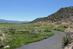
44:The Rio Culebra near the town of
530:. U.S. Department of Agriculture
64:
57:
38:
762:Irrigation in the United States
276:. The Rio Culebra rises in the
209: • coordinates
135: • coordinates
1:
757:Tributaries of the Rio Grande
681:"Sangre de Cristo Land Grant"
107:Physical characteristics
727:GPX (secondary coordinates)
656:Culebra River Villages 1986
644:Culebra River Villages 1986
350:Sangre de Cristo Land Grant
197: • location
125: • location
788:
398:List of rivers of Colorado
310:Sangre de Cristo Mountains
278:Sangre de Cristo Mountains
772:Spanish words and phrases
722:GPX (primary coordinates)
697:Map all coordinates using
575:"San Luis People's Ditch"
352:awarded to the family of
274:Costilla County, Colorado
263:
181:
111:
101:Costilla County, Colorado
52:
37:
705:Download coordinates as:
584:. National Park Service
435:. Viewed June 29, 2012.
259:30 mi (48 km)
717:GPX (all coordinates)
685:Colorado Encyclopedia
668:Hicks & Pena 2003
632:Hicks & Pena 2003
554:Colorado Encyclopedia
169:Culebra Creek, source
284:west of the town of
243:Culebra Creek, mouth
73:Location in Colorado
611:History of Colorado
582:Library of Congress
324:where it joins the
227: /
153: /
747:Rivers of Colorado
496:"Climate San Luis"
431:2013-04-08 at the
232:37.180°N 105.431°W
158:37.183°N 105.730°W
767:Irrigation canals
500:U.S. Climate Data
314:Sanchez Reservoir
267:
266:
27:River in Colorodo
16:(Redirected from
779:
689:
688:
677:
671:
665:
659:
653:
647:
641:
635:
629:
623:
622:
620:
618:
608:
600:
594:
593:
591:
589:
579:
571:
565:
564:
562:
560:
546:
540:
539:
537:
535:
520:
511:
510:
508:
506:
492:
486:
485:
469:
463:
460:
454:
453:
442:
436:
422:
384:and other uses.
358:Taos, New Mexico
251:
250:
248:
247:
246:
244:
239:
238:
237:37.180; -105.431
233:
228:
225:
224:
223:
220:
177:
176:
174:
173:
172:
170:
165:
164:
163:37.183; -105.730
159:
154:
151:
150:
149:
146:
136:
126:
68:
67:
61:
42:
30:
21:
787:
786:
782:
781:
780:
778:
777:
776:
737:
736:
735:
734:
733:
732:
731:
692:
679:
678:
674:
666:
662:
654:
650:
646:, p. 9-10.
642:
638:
630:
626:
616:
614:
606:
602:
601:
597:
587:
585:
577:
573:
572:
568:
558:
556:
548:
547:
543:
533:
531:
522:
521:
514:
504:
502:
494:
493:
489:
471:
470:
466:
461:
457:
446:"Culebra Range"
444:
443:
439:
433:Wayback Machine
423:
419:
415:
394:
354:Carlos Beaubien
342:
322:San Luis Valley
302:
242:
240:
236:
234:
230:
229:
226:
221:
218:
216:
214:
213:
210:
198:
168:
166:
162:
160:
156:
155:
152:
147:
144:
142:
140:
139:
134:
124:
77:
76:
75:
74:
71:
70:
69:
48:
28:
23:
22:
15:
12:
11:
5:
785:
783:
775:
774:
769:
764:
759:
754:
749:
739:
738:
730:
729:
724:
719:
714:
708:
702:
695:
694:
693:
691:
690:
672:
670:, p. 395.
660:
648:
636:
634:, p. 417.
624:
595:
566:
541:
512:
487:
464:
455:
437:
416:
414:
411:
410:
409:
400:
393:
390:
341:
338:
301:
298:
265:
264:
261:
260:
257:
253:
252:
211:
208:
205:
204:
199:
196:
193:
192:
189:
183:
182:
179:
178:
137:
131:
130:
127:
121:
120:
117:
113:
112:
109:
108:
104:
103:
98:
94:
93:
88:
84:
83:
79:
78:
72:
63:
62:
56:
55:
54:
53:
50:
49:
43:
35:
34:
26:
24:
14:
13:
10:
9:
6:
4:
3:
2:
784:
773:
770:
768:
765:
763:
760:
758:
755:
753:
750:
748:
745:
744:
742:
728:
725:
723:
720:
718:
715:
713:
710:
709:
707:
706:
701:
700:OpenStreetMap
698:
686:
682:
676:
673:
669:
664:
661:
658:, p. 13.
657:
652:
649:
645:
640:
637:
633:
628:
625:
612:
605:
599:
596:
583:
576:
570:
567:
555:
551:
545:
542:
529:
525:
519:
517:
513:
501:
497:
491:
488:
483:
479:
475:
468:
465:
459:
456:
451:
447:
441:
438:
434:
430:
427:
421:
418:
412:
407:
404:
401:
399:
396:
395:
391:
389:
387:
381:
377:
373:
371:
367:
363:
359:
355:
351:
347:
339:
337:
333:
329:
327:
323:
319:
315:
311:
307:
299:
297:
295:
292:built by its
291:
287:
283:
279:
275:
271:
262:
258:
254:
249:
212:
206:
203:
200:
194:
190:
188:
184:
180:
175:
138:
132:
128:
122:
118:
114:
110:
105:
102:
99:
95:
92:
91:United States
89:
85:
80:
60:
51:
47:
41:
36:
31:
19:
18:Culebra Creek
704:
703:
696:
684:
675:
663:
651:
639:
627:
615:. Retrieved
610:
598:
586:. Retrieved
581:
569:
557:. Retrieved
553:
544:
532:. Retrieved
527:
524:"Culebra #2"
503:. Retrieved
499:
490:
481:
477:
467:
462:Google Earth
458:
449:
440:
420:
405:
382:
378:
374:
343:
334:
330:
306:Culebra Peak
303:
269:
268:
346:Ute Indians
270:Rio Culebra
235: /
222:105°25′52″W
161: /
148:105°43′48″W
33:Rio Culebra
741:Categories
550:"San Luis"
450:Peakbagger
413:References
366:San Acacio
326:Rio Grande
282:Rio Grande
241: (
219:37°10′48″N
202:Rio Grande
167: (
145:37°10′59″N
617:1 October
588:1 October
559:1 October
534:1 October
505:1 October
484:(3): 395.
362:San Pablo
300:Geography
429:Archived
392:See also
364:(1852),
318:San Luis
294:Hispanic
290:acequias
286:San Luis
97:Location
82:Location
46:San Luis
340:History
87:Country
256:Length
191:
119:
116:Source
607:(PDF)
578:(PDF)
408:, PBS
386:Anglo
370:Chama
187:Mouth
619:2022
590:2022
561:2022
536:2022
507:2022
712:KML
743::
683:.
609:.
580:.
552:.
526:.
515:^
498:.
482:74
480:.
476:.
448:.
687:.
621:.
592:.
563:.
538:.
509:.
452:.
245:)
171:)
20:)
Text is available under the Creative Commons Attribution-ShareAlike License. Additional terms may apply.