1579:
1523:
1622:
1547:
1535:
42:
2298:
1511:
1606:
1594:
1499:
1474:. The university plan proposes development around Old Cullowhee Road to create a traditional downtown, with mixed-use buildings, a city hall, homes, walkable neighborhoods, supermarket, and trails/parks along the river and throughout the area. The elementary school could be relocated here, as well as the Post Office and other town/city functions. A "town center" to be constructed on some 35 acres (14 ha) owned by WCU is an area targeted for annexation and development.
1567:
1132:
served until 1964. Both of these buildings were located on what is now the university campus. From 1964 to 1994, the public school was known as
Cordelia Camp Laboratory School, still associated with educational programs at the university. The Cullowhee Valley School is the latest structure holding the school, which now serves grades K-8. Students go to Sylva for high school.
1094:
1440:. WCU faculty have also worked with EBCI representatives on surveys of historic town and earthwork mound sites, to create a database of known resources; archeological and anthropological studies conducted with outreach to the Cherokee people to gain their perspective from tribal oral histories, and other programs. More than 50
54:
1112:
The institution ceased to be named a high school in 1923. A new brick building was opened serving grades 1–11. In 1940, a massive flood caused severe damage to the business district, destroying almost all the buildings on the north side of the river. The buildings on the south side survived, though
1477:
The plan is controversial, as it may attract business away from Old
Cullowhee Road and would be intended to attract chain stores and businesses, rather than local small businesses. The "town center" is proposed to accommodate as much as 270,000 square feet (25,000 m) of commercial, housing and
1397:
In the CDP, the population was spread out, with 5.9% under the age of 18, 72.8% from 18 to 24, 11.0% from 25 to 44, 7.0% from 45 to 64, and 3.2% who were 65 years of age or older. The median age was 21 years. Both the overall age distribution and the median age are driven by the presence of
Western
1131:
As noted, the town has had a public school since 1923, which has been in four buildings. It has always been associated with teacher training at the college (and now university). It was established as
Cullowhee Training School, serving until 1939. It was replaced by the McKee Training School, which
1085:
The
Cherokee were forced to cede their land in this area in the early nineteenth century. When European-American settlers moved in, they occupied the site of the former Cherokee village. Cullowhee became one of the first European-American settlements in Jackson County. Residents reportedly founded
1486:
An alternative vision for redevelopment is offered by the
Cullowhee Revitalization Endeavor (CuRvE), made up of local businessmen and activists who also want to rejuvenate the once-thriving commerce center. CuRvE wants to make Cullowhee "a unique and highly attractive area—a mix of residences and
1393:
couples living together, 7.3% had a female householder with no husband present, and 61.9% were non-families. Households made up of individuals represented 35.9%, and 5.0% had someone living alone who was 65 years of age or older. The average household size was 2.01 and the average family size was
1123:
Businesses in the Old
Cullowhee Road area declined in the late 20th century after it was bypassed by the relocation of highway N.C. 107 in the late 1970s to early 1980s. But, since the 1960s, the development of Western Carolina University has stimulated growth around its large campus. In the 21st
1424:
system. WCU is the fifth-oldest institution in the UNC system. It was founded in 1889 with a few hundred students in a small, one-story wood building. In the 21st century, it has more than 12,000 students, offering approximately 220 majors and concentrations for undergraduates, and more than 45
1487:
businesses along rivers and streams". According to CuRvE, its vision has more community support than that the
Western Carolina University "town center", because it would allow small businesses. In addition, it would make use of the setting of Old Cullowhee Road along a mountain river.
1578:
1089:
In 1883, Roland A. Painter founded
Painter Post Office, located in his store on the Old Cullowhee Road. Other businesses clustered there. The post office was renamed as "Cullowhee" in 1908, taking over from another post office in the vicinity of nearby Forest Hills.
1482:
Outreach Center (former
Cordelia Camp Laboratory School, built in 1964), intramural fields, and several parking lots. The annexation will also include the area that is the business district on Old Cullowhee Road (S.R. 1002) near the former campus entrance.
1120:. When the area rebuilt, buildings were developed on the higher ground around Old Cullowhee Road, and the area closer to the river floodplain was abandoned. The mid-century buildings have since become outdated, particularly compared to newer developments.
1621:
1380:
As of the 2000 census, there were 716 households, and 272 families residing in the CDP. The population density was 983.1 inhabitants per square mile (379.6/km). There were 823 housing units at an average density of 226.1 per square mile (87.3/km). The
1078:. Archeological evidence from excavations at Cullowhee Mound suggests that this area had been occupied since 3000 BCE by cultures of indigenous peoples. The historic Cherokee developed a style of public architecture characterized by building large
1546:
1668:
1127:
The university has proposed a new Town Center to incorporate some of its land. (See "Plans" below). Businessmen are also collaborating on revitalization of Old Cullowhee Road, and many new homes are being built or planned for the area.
1385:
of the CDP was 88.91% White, 7.24% African American, 0.95% Native American, 1.34% Asian, 0.08% Pacific Islander, 0.53% from other races, and 0.95% from two or more races. Hispanic or Latino of any race were 1.31% of the population.
1124:
century, the university has 12,000 students, and offers a variety of related sports and cultural programs. Cullowhee has also been a destination for retirees and people with second homes, resulting in new residential construction.
2488:
1522:
1865:
1086:
the first school in the area, a one-room school in 1830. They developed the floodplain area for agriculture. The settlers cleared more land during the 1800s than the Cherokee had cultivated.
1082:, or council houses, on top of the mounds. This was the center place for the community to gather, and the town elders to meet in council. It expressed the consensus nature of their society.
1566:
2220:
1605:
1401:
The median income for a household in the CDP was $ 19,688, and the median income for a family was $ 36,538. Males had a median income of $ 26,161 versus $ 16,607 for females. The
1498:
2493:
2040:
1478:
multi-tenant office space, with parking for 871 vehicles. A 320-space parking garage is proposed on 22 acres of land owned by the university. The land is now the site of the
356:
town, which was centered around the earthwork Cullowhee Mound. The name was long thought to mean "Valley of the Lilies." In fact, it is derived from the Cherokee phrase
1821:
1470:, an incorporated village just south of Cullowhee, is considering a WCU plan to incorporate as the town/city of Cullowhee, annexing areas along Old Cullowhee Road and
1451:, opened in 1994. It replaced a 30-year-old structure on the University's Campus. Since 1988, when the town's high school closed, students of high school age attend
1967:
1534:
67:
41:
2213:
1510:
1761:
1791:
1774:
1105:
for teacher training. Later its offerings were expanded into a four-year college curriculum, and ultimately graduate departments supporting today's
407:
Cullowhee typically has a rather mild winter season. In the summer, high temperatures can reach into the 90s Fahrenheit (32-plus degrees Celsius).
2206:
1612:
1593:
1382:
1075:
346:
1929:
1144:
1687:
121:
1425:
graduate-level programs of study. The campus covers approximately 600 acres (240 ha) and takes up much of the Cullowhee Valley.
1891:
53:
2198:
1628:
1429:
200:
1753:
1135:
The oldest surviving European-American structure in the area is St. David's in the Valley church, which was built in 1880. The
364:, a giant warrior and hunter who the Cherokee believe lived in the area, is an important figure in their religion and culture.
2230:
1829:
1312:
1272:
1159:
311:
126:
2458:
2128:
1286:
2316:
1467:
1421:
338:
2057:
1730:
1632:
1557:
1417:
1325:
1106:
396:
334:
2016:
2406:
1799:
1452:
389:
377:
2350:
2276:
2271:
1369:
1357:
1215:
1200:
327:
323:
2401:
2355:
2339:
2334:
2308:
1433:
1151:
237:
99:
1711:
1572:
Western Carolina University in 2007, before work on the Quad, new dormitories, and Courtyard Cafeteria started
2411:
2326:
2287:
1972:
1448:
307:
32:
2416:
2396:
2381:
1338:
2183:
1428:
It has created a Cherokee Studies program, including language immersion study, in collaboration with the
2376:
2282:
2263:
2252:
1934:
1456:
1389:
There were 716 households, of which 17.5% had children under the age of 18 living with them, 28.1% were
381:
2465:
2386:
1342:
210:
2391:
2366:
2175:
1299:
1258:
1113:
waterlogged. The flood crested at 21 feet (6.4 m) above Cullowhee Dam, the highest on record.
2080:
2426:
2103:
2081:"REVISITING PLATFORM MOUNDS AND TOWNHOUSES IN THE CHEROKEE HEARTLAND: A COLLABORATIVE APPROACH"
1101:
In 1889, Cullowhee High School was founded by Robert Lee Madison. It eventually developed as a
2192:
1402:
1155:
1405:
for the CDP was $ 10,017. About 25.2% of families and 41.5% of the population were below the
2095:
1650:
1117:
373:
319:
277:
1504:
The Joyner Building was the main Western Carolina University building from 1916 until 1939.
2434:
2187:
2155:
1792:"Geographic Identifiers: 2010 Census Summary File 1 (G001): Cullowhee CDP, North Carolina"
1757:
1437:
1136:
1066:
Developed along a mountain river valley and by a creek, Cullowhee was known as a historic
353:
1899:
1631:
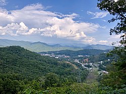
passed over Cullowhee on August 21, 2017. This is an image as viewed from the campus of
1441:
1140:
1071:
361:
315:
114:
414:
Climate data for Cullowhee, North Carolina (1991–2020 normals, extremes 1909–present)
2482:
2107:
2052:
1750:
1712:
U.S. Geological Survey Geographic Names Information System: Cullowhee, North Carolina
1584:
1553:
1479:
1116:
Since then, dams have been built for flood control on the East and West forks of the
1102:
814:
342:
242:
1843:
2099:
1406:
1398:
Carolina University. For every 100 females age 18 and over, there were 84.4 males.
1360:, there were 7,682 people, 1,269 households, and 165 families residing in the CDP.
1093:
399:, the Cullowhee CDP has a total area of 3.5 square miles (9.1 km), all land.
345:, it has 12,000 students and has become a strong influence in community life. The
1587:
Building (ex-Cordelia Camp Laboratory School), Western Carolina University (1964)
1444:
sites have been identified in the eleven westernmost counties of North Carolina.
2245:
1994:
1655:
1646:
385:
2132:
1669:
National Register of Historic Places listings in Jackson County, North Carolina
1948:
1775:"Cullowhee CDP, North Carolina Demographics and Housing 2020 Decennial Census"
1079:
109:
1162:) as number 13 in the United States. Reasons included the area's status as a
82:
69:
249:
191:
1409:, including 37.3% of those under age 18 and 9.6% of those age 65 or over.
2449:‡This populated place also has portions in an adjacent county or counties
1067:
225:
1390:
1163:
1822:"Cherokee instructor discusses possible evolution of word "Cullowhee""
2159:
1968:"Thriving, not just surviving: Cullowhee named a top US 'micropolis'"
1471:
372:
Cullowhee is located in central Jackson County in the valley of the
1953:
Weekly List of Actions Taken on Properties: 4/01/13 through 4/05/13
1870:
U.S. Climate Normals 2020: U.S. Monthly Climate Normals (1991-2020)
1432:, the only federally recognized tribe in the state. It is based in
1092:
380:
runs through the community, leading north 6 miles (10 km) to
217:
196:
1924:
1166:
and " superior job growth, wage increases and young businesses."
1052:
259:
2202:
2180:
1892:"UNC Asheville Hosts Talk on "Excavations at Cullowhee Mound""
298:
2296:
295:
292:
2489:
Census-designated places in Jackson County, North Carolina
352:
The present community developed at the site of a historic
1726:
1074:
estimated to have been built by 1000 CE by people of the
286:
18:
Census-designated place in North Carolina, United States
1913:
The History of Jackson County Sesquicentennial Edition
1556:
hosts many local events, as well as many of the major
1097:
Robert Lee Madison, founder of Cullowhee High School.
283:
1760:, from the North Carolina Collection website at the
289:
2444:
2425:
2365:
2325:
2307:
2262:
2041:
List of colleges and universities in North Carolina
280:
258:
248:
236:
224:
207:
190:
182:
174:
169:
161:
153:
145:
137:
132:
120:
108:
98:
23:
1872:. National Oceanic and Atmospheric Administration
1846:. National Oceanic and Atmospheric Administration
1599:Cullowhee Valley K-8 School, located along NC 107
322:, and the permanent population was 7,682 at the
1949:"National Register of Historic Places Listings"
2214:
1786:
1784:
8:
360:, which translates as "Judacullah's Place."
1762:University of North Carolina at Chapel Hill
2494:Census-designated places in North Carolina
2221:
2207:
2199:
2053:"Western Carolina University - Fast Facts"
1173:
410:
20:
1615:on Berry Ridge above Little Savannah Road
2181:CuRvE, Cullowhee Revitalization Endeavor
1966:Brown, Elizabeth Anne (March 23, 2019).
1955:. National Park Service. April 12, 2013.
1240:
388:, and southeast 7 miles (11 km) to
349:is located just outside the CDP limits.
1679:
1649:, professional baseball player for the
1516:St. David's-in-The-Valley Church (1886)
1494:
1076:South Appalachian Mississippian culture
247:
223:
189:
168:
160:
131:
97:
62:
50:
38:
1925:"National Register Information System"
1707:
1705:
1193:
318:, United States. It is located on the
1721:
1719:
1070:village centered around an earthwork
257:
235:
206:
181:
173:
152:
144:
136:
119:
107:
58:Location of Cullowhee, North Carolina
7:
2156:"Eclipse - Cullowhee North Carolina"
1930:National Register of Historic Places
1844:"NowData - NOAA Online Weather Data"
1798:. U.S. Census Bureau. Archived from
1145:National Register of Historic Places
341:. Developing from a high school and
2154:Reinhart, Vince (August 21, 2017).
1528:Former McKee Training School (1939)
339:University of North Carolina System
157:0.00 sq mi (0.00 km)
149:3.81 sq mi (9.86 km)
141:3.81 sq mi (9.86 km)
46:Cullowhee, the Valley of the Lilies
2229:Municipalities and communities of
1995:"Census of Population and Housing"
1898:. November 2, 2004. Archived from
1183:
14:
2131:. Gocullowhee.org. Archived from
1828:. August 25, 2010. Archived from
1688:"ArcGIS REST Services Directory"
1620:
1604:
1592:
1577:
1565:
1545:
1533:
1521:
1509:
1497:
1430:Eastern Band of Cherokee Indians
276:
52:
40:
1420:is a constituent campus of the
186:2,017.33/sq mi (778.91/km)
2232:Jackson County, North Carolina
2100:10.1179/2168472315Y.0000000001
1:
1690:. United States Census Bureau
1242:Cullowhee racial composition
887:Average snowfall inches (cm)
333:The community is the home of
2435:Eastern Cherokee Reservation
2079:Steere, Benjamin A. (2015).
1447:The public K thru 8 school,
1422:University of North Carolina
1154:report ranked the Cullowhee
2058:Western Carolina University
1731:United States Census Bureau
1611:Cullowhee as seen from the
1558:Western Carolina University
1418:Western Carolina University
1372:, there were 6,228 people.
1107:Western Carolina University
957:Average precipitation days
673:Mean daily minimum °F (°C)
533:Mean daily maximum °F (°C)
397:United States Census Bureau
335:Western Carolina University
2512:
1453:Smoky Mountain High School
1050:
413:
378:North Carolina Highway 107
165:2,156 ft (657 m)
2454:
2294:
2243:
2186:December 4, 2010, at the
2129:"CuRvE News | CuRvE"
1358:2020 United States census
1337:
1324:
1311:
1298:
1285:
1273:Black or African American
1271:
1257:
1252:
1249:
1246:
1229:
1214:
1199:
1192:
1187:
1182:
1179:
1003:
956:
886:
812:
742:
672:
602:
532:
462:
457:
454:
451:
448:
445:
442:
439:
436:
433:
430:
427:
424:
421:
418:
63:
51:
39:
30:
25:Cullowhee, North Carolina
2088:Southeastern Archaeology
1866:"Station: Cullowhee, NC"
1540:Cullowhee Baptist Church
1434:Cherokee, North Carolina
1152:Walton Family Foundation
1973:Asheville Citizen-Times
1764:. Retrieved 2013-01-29.
1449:Cullowhee Valley School
1143:are each listed on the
308:census-designated place
33:Census-designated place
2301:
1613:Jackson County Airport
1098:
347:Jackson County Airport
2460:North Carolina portal
2300:
2017:"Explore Census Data"
1935:National Park Service
1751:"Talk Like a Tarheel"
1727:"U.S. Census website"
1230:U.S. Decennial Census
1175:Historical population
1096:
326:up from 6,228 at the
209: • Summer (
83:35.30972°N 83.18167°W
2467:United States portal
1802:on February 13, 2020
463:Record high °F (°C)
183: • Density
1796:American Factfinder
1243:
1176:
1164:tourist destination
1004:Average snowy days
743:Record low °F (°C)
603:Daily mean °F (°C)
88:35.30972; -83.18167
79: /
2427:Indian reservation
2302:
1756:2013-06-22 at the
1241:
1174:
1099:
175: • Total
154: • Water
138: • Total
2476:
2475:
2176:Community website
2135:on April 21, 2012
1832:on April 9, 2016.
1403:per capita income
1354:
1353:
1234:
1233:
1156:micropolitan area
1058:
1057:
395:According to the
358:joolth-cullah-wee
269:
268:
146: • Land
2501:
2468:
2461:
2299:
2255:
2248:
2238:
2233:
2223:
2216:
2209:
2200:
2195:at City-Data.com
2164:
2163:
2151:
2145:
2144:
2142:
2140:
2125:
2119:
2118:
2116:
2114:
2085:
2076:
2070:
2069:
2067:
2065:
2049:
2043:
2038:
2032:
2031:
2029:
2027:
2013:
2007:
2006:
2004:
2002:
1991:
1985:
1984:
1982:
1980:
1963:
1957:
1956:
1945:
1939:
1938:
1921:
1915:
1910:
1904:
1903:
1902:on May 19, 2012.
1888:
1882:
1881:
1879:
1877:
1862:
1856:
1855:
1853:
1851:
1840:
1834:
1833:
1818:
1812:
1811:
1809:
1807:
1788:
1779:
1778:
1771:
1765:
1748:
1742:
1741:
1739:
1737:
1723:
1714:
1709:
1700:
1699:
1697:
1695:
1684:
1651:Seattle Mariners
1624:
1608:
1596:
1581:
1569:
1560:sports programs.
1549:
1537:
1525:
1513:
1501:
1313:Pacific Islander
1244:
1195:
1190:
1185:
1177:
1118:Tuckasegee River
1007:
960:
411:
374:Tuckasegee River
320:Tuckasegee River
305:
304:
301:
300:
297:
294:
291:
288:
285:
282:
214:
94:
93:
91:
90:
89:
84:
80:
77:
76:
75:
72:
56:
44:
21:
2511:
2510:
2504:
2503:
2502:
2500:
2499:
2498:
2479:
2478:
2477:
2472:
2466:
2459:
2450:
2440:
2421:
2368:
2361:
2321:
2303:
2297:
2292:
2258:
2253:
2246:
2239:
2236:
2231:
2227:
2193:Cullowhee entry
2188:Wayback Machine
2172:
2167:
2153:
2152:
2148:
2138:
2136:
2127:
2126:
2122:
2112:
2110:
2083:
2078:
2077:
2073:
2063:
2061:
2051:
2050:
2046:
2039:
2035:
2025:
2023:
2021:data.census.gov
2015:
2014:
2010:
2000:
1998:
1993:
1992:
1988:
1978:
1976:
1965:
1964:
1960:
1947:
1946:
1942:
1937:. July 9, 2010.
1923:
1922:
1918:
1911:
1907:
1890:
1889:
1885:
1875:
1873:
1864:
1863:
1859:
1849:
1847:
1842:
1841:
1837:
1820:
1819:
1815:
1805:
1803:
1790:
1789:
1782:
1773:
1772:
1768:
1758:Wayback Machine
1749:
1745:
1735:
1733:
1725:
1724:
1717:
1710:
1703:
1693:
1691:
1686:
1685:
1681:
1677:
1665:
1643:
1636:
1625:
1616:
1609:
1600:
1597:
1588:
1582:
1573:
1570:
1561:
1550:
1541:
1538:
1529:
1526:
1517:
1514:
1505:
1502:
1493:
1465:
1438:Qualla Boundary
1415:
1378:
1366:
1287:Native American
1275:(non-Hispanic)
1261:(non-Hispanic)
1239:
1188:
1172:
1137:Joyner Building
1064:
1059:
1005:
958:
951:
946:
941:
936:
931:
926:
921:
916:
911:
906:
901:
896:
891:
881:
876:
871:
866:
861:
856:
851:
846:
841:
836:
831:
826:
821:
807:
802:
797:
792:
787:
782:
777:
772:
767:
762:
757:
752:
747:
737:
732:
727:
722:
717:
712:
707:
702:
697:
692:
687:
682:
677:
667:
662:
657:
652:
647:
642:
637:
632:
627:
622:
617:
612:
607:
597:
592:
587:
582:
577:
572:
567:
562:
557:
552:
547:
542:
537:
527:
522:
517:
512:
507:
502:
497:
492:
487:
482:
477:
472:
467:
405:
370:
279:
275:
232:
208:
87:
85:
81:
78:
73:
70:
68:
66:
65:
59:
47:
35:
26:
19:
12:
11:
5:
2509:
2508:
2505:
2497:
2496:
2491:
2481:
2480:
2474:
2473:
2471:
2470:
2463:
2455:
2452:
2451:
2448:
2446:
2442:
2441:
2439:
2438:
2431:
2429:
2423:
2422:
2420:
2419:
2414:
2409:
2404:
2399:
2394:
2389:
2384:
2379:
2373:
2371:
2367:Unincorporated
2363:
2362:
2360:
2359:
2353:
2348:
2343:
2337:
2331:
2329:
2323:
2322:
2320:
2319:
2313:
2311:
2305:
2304:
2295:
2293:
2291:
2290:
2285:
2280:
2274:
2268:
2266:
2260:
2259:
2244:
2241:
2240:
2228:
2226:
2225:
2218:
2211:
2203:
2197:
2196:
2190:
2178:
2171:
2170:External links
2168:
2166:
2165:
2146:
2120:
2094:(3): 196–219.
2071:
2044:
2033:
2008:
1986:
1958:
1940:
1916:
1905:
1883:
1857:
1835:
1813:
1780:
1766:
1743:
1715:
1701:
1678:
1676:
1673:
1672:
1671:
1664:
1661:
1660:
1659:
1653:
1642:
1641:Notable people
1639:
1638:
1637:
1626:
1619:
1617:
1610:
1603:
1601:
1598:
1591:
1589:
1583:
1576:
1574:
1571:
1564:
1562:
1551:
1544:
1542:
1539:
1532:
1530:
1527:
1520:
1518:
1515:
1508:
1506:
1503:
1496:
1492:
1489:
1464:
1461:
1442:platform mound
1414:
1411:
1377:
1374:
1370:census of 2010
1365:
1362:
1352:
1351:
1348:
1345:
1335:
1334:
1331:
1328:
1322:
1321:
1318:
1315:
1309:
1308:
1305:
1302:
1296:
1295:
1292:
1289:
1283:
1282:
1279:
1276:
1269:
1268:
1265:
1262:
1255:
1254:
1251:
1248:
1238:
1235:
1232:
1231:
1227:
1226:
1223:
1221:
1218:
1212:
1211:
1208:
1206:
1203:
1197:
1196:
1191:
1186:
1181:
1171:
1168:
1160:Jackson County
1141:Judaculla Rock
1072:platform mound
1063:
1060:
1056:
1055:
1048:
1047:
1044:
1041:
1038:
1035:
1032:
1029:
1026:
1023:
1020:
1017:
1014:
1011:
1008:
1001:
1000:
997:
994:
991:
988:
985:
982:
979:
976:
973:
970:
967:
964:
961:
954:
953:
948:
943:
938:
933:
928:
923:
918:
913:
908:
903:
898:
893:
888:
884:
883:
878:
873:
868:
863:
858:
853:
848:
843:
838:
833:
828:
823:
818:
810:
809:
804:
799:
794:
789:
784:
779:
774:
769:
764:
759:
754:
749:
744:
740:
739:
734:
729:
724:
719:
714:
709:
704:
699:
694:
689:
684:
679:
674:
670:
669:
664:
659:
654:
649:
644:
639:
634:
629:
624:
619:
614:
609:
604:
600:
599:
594:
589:
584:
579:
574:
569:
564:
559:
554:
549:
544:
539:
534:
530:
529:
524:
519:
514:
509:
504:
499:
494:
489:
484:
479:
474:
469:
464:
460:
459:
456:
453:
450:
447:
444:
441:
438:
435:
432:
429:
426:
423:
420:
416:
415:
409:
404:
401:
384:, the Jackson
369:
366:
337:, part of the
316:North Carolina
312:Jackson County
267:
266:
263:
256:
255:
252:
246:
245:
240:
234:
233:
230:
228:
222:
221:
215:
205:
204:
194:
188:
187:
184:
180:
179:
176:
172:
171:
167:
166:
163:
159:
158:
155:
151:
150:
147:
143:
142:
139:
135:
134:
130:
129:
124:
118:
117:
115:North Carolina
112:
106:
105:
102:
96:
95:
61:
60:
57:
49:
48:
45:
37:
36:
31:
28:
27:
24:
17:
13:
10:
9:
6:
4:
3:
2:
2507:
2506:
2495:
2492:
2490:
2487:
2486:
2484:
2469:
2464:
2462:
2457:
2456:
2453:
2447:
2443:
2436:
2433:
2432:
2430:
2428:
2424:
2418:
2415:
2413:
2410:
2408:
2405:
2403:
2400:
2398:
2395:
2393:
2390:
2388:
2385:
2383:
2380:
2378:
2375:
2374:
2372:
2370:
2364:
2357:
2354:
2352:
2349:
2347:
2344:
2341:
2338:
2336:
2333:
2332:
2330:
2328:
2324:
2318:
2315:
2314:
2312:
2310:
2306:
2289:
2286:
2284:
2281:
2278:
2275:
2273:
2270:
2269:
2267:
2265:
2261:
2257:
2256:
2249:
2242:
2237:United States
2234:
2224:
2219:
2217:
2212:
2210:
2205:
2204:
2201:
2194:
2191:
2189:
2185:
2182:
2179:
2177:
2174:
2173:
2169:
2161:
2157:
2150:
2147:
2134:
2130:
2124:
2121:
2109:
2105:
2101:
2097:
2093:
2089:
2082:
2075:
2072:
2064:September 29,
2060:
2059:
2054:
2048:
2045:
2042:
2037:
2034:
2022:
2018:
2012:
2009:
1996:
1990:
1987:
1975:
1974:
1969:
1962:
1959:
1954:
1950:
1944:
1941:
1936:
1932:
1931:
1926:
1920:
1917:
1914:
1909:
1906:
1901:
1897:
1896:UNC Asheville
1893:
1887:
1884:
1871:
1867:
1861:
1858:
1845:
1839:
1836:
1831:
1827:
1823:
1817:
1814:
1801:
1797:
1793:
1787:
1785:
1781:
1776:
1770:
1767:
1763:
1759:
1755:
1752:
1747:
1744:
1732:
1728:
1722:
1720:
1716:
1713:
1708:
1706:
1702:
1694:September 20,
1689:
1683:
1680:
1674:
1670:
1667:
1666:
1662:
1657:
1654:
1652:
1648:
1645:
1644:
1640:
1634:
1630:
1629:solar eclipse
1623:
1618:
1614:
1607:
1602:
1595:
1590:
1586:
1585:Cordelia Camp
1580:
1575:
1568:
1563:
1559:
1555:
1554:Ramsey Center
1548:
1543:
1536:
1531:
1524:
1519:
1512:
1507:
1500:
1495:
1490:
1488:
1484:
1481:
1480:Cordelia Camp
1475:
1473:
1469:
1462:
1460:
1458:
1454:
1450:
1445:
1443:
1439:
1435:
1431:
1426:
1423:
1419:
1412:
1410:
1408:
1404:
1399:
1395:
1392:
1387:
1384:
1383:racial makeup
1375:
1373:
1371:
1363:
1361:
1359:
1349:
1346:
1344:
1340:
1336:
1332:
1329:
1327:
1323:
1319:
1316:
1314:
1310:
1306:
1303:
1301:
1297:
1293:
1290:
1288:
1284:
1280:
1277:
1274:
1270:
1266:
1263:
1260:
1256:
1245:
1236:
1228:
1224:
1222:
1219:
1217:
1213:
1209:
1207:
1204:
1202:
1198:
1178:
1169:
1167:
1165:
1161:
1157:
1153:
1148:
1146:
1142:
1138:
1133:
1129:
1125:
1121:
1119:
1114:
1110:
1108:
1104:
1103:normal school
1095:
1091:
1087:
1083:
1081:
1077:
1073:
1069:
1061:
1054:
1049:
1045:
1042:
1039:
1036:
1033:
1030:
1027:
1024:
1021:
1018:
1015:
1012:
1009:
1002:
998:
995:
992:
989:
986:
983:
980:
977:
974:
971:
968:
965:
962:
955:
949:
944:
939:
934:
929:
924:
919:
914:
909:
904:
899:
894:
889:
885:
879:
874:
869:
864:
859:
854:
849:
844:
839:
834:
829:
824:
819:
816:
815:precipitation
811:
805:
800:
795:
790:
785:
780:
775:
770:
765:
760:
755:
750:
745:
741:
735:
730:
725:
720:
715:
710:
705:
700:
695:
690:
685:
680:
675:
671:
665:
660:
655:
650:
645:
640:
635:
630:
625:
620:
615:
610:
605:
601:
595:
590:
585:
580:
575:
570:
565:
560:
555:
550:
545:
540:
535:
531:
525:
520:
515:
510:
505:
500:
495:
490:
485:
480:
475:
470:
465:
461:
417:
412:
408:
402:
400:
398:
393:
391:
387:
383:
379:
375:
367:
365:
363:
359:
355:
350:
348:
344:
343:normal school
340:
336:
331:
329:
325:
321:
317:
313:
309:
303:
273:
264:
261:
253:
251:
244:
241:
239:
229:
227:
219:
216:
212:
202:
201:Eastern (EST)
198:
195:
193:
185:
177:
164:
156:
148:
140:
128:
125:
123:
116:
113:
111:
104:United States
103:
101:
92:
64:Coordinates:
55:
43:
34:
29:
22:
16:
2345:
2317:Forest Hills
2251:
2158:– via
2149:
2137:. Retrieved
2133:the original
2123:
2113:December 15,
2111:. Retrieved
2091:
2087:
2074:
2062:. Retrieved
2056:
2047:
2036:
2026:December 19,
2024:. Retrieved
2020:
2011:
1999:. Retrieved
1997:. Census.gov
1989:
1977:. Retrieved
1971:
1961:
1952:
1943:
1928:
1919:
1912:
1908:
1900:the original
1895:
1886:
1874:. Retrieved
1869:
1860:
1848:. Retrieved
1838:
1830:the original
1826:The Reporter
1825:
1816:
1804:. Retrieved
1800:the original
1795:
1769:
1746:
1734:. Retrieved
1692:. Retrieved
1682:
1485:
1476:
1468:Forest Hills
1466:
1446:
1427:
1416:
1407:poverty line
1400:
1396:
1388:
1379:
1367:
1355:
1170:Demographics
1149:
1134:
1130:
1126:
1122:
1115:
1111:
1100:
1088:
1084:
1065:
817:inches (mm)
406:
394:
371:
357:
351:
332:
271:
270:
15:
2369:communities
2247:County seat
1736:January 31,
1656:Nick Searcy
1647:Cal Raleigh
1376:2000 census
1364:2010 census
1326:Other/Mixed
1253:Percentage
1237:2020 census
1080:town houses
959:(≥ 0.01 in)
386:county seat
328:2010 census
324:2020 census
86: /
2483:Categories
2407:Tuckasegee
1876:August 16,
1850:August 16,
1806:October 9,
1675:References
1455:in nearby
1368:As of the
1356:As of the
1006:(≥ 0.1 in)
390:Tuckasegee
362:Judacullah
262:feature ID
170:Population
74:83°10′54″W
71:35°18′35″N
2445:Footnotes
2351:Glenville
2346:Cullowhee
2277:Highlands
2272:Dillsboro
2139:April 28,
2108:155444628
1979:March 25,
1413:Education
368:Geography
310:(CDP) in
272:Cullowhee
250:FIPS code
238:Area code
192:Time zone
162:Elevation
2402:Savannah
2356:Whittier
2340:Cherokee
2335:Cashiers
2184:Archived
1754:Archived
1663:See also
1339:Hispanic
1068:Cherokee
1051:Source:
882:(1,376)
813:Average
354:Cherokee
254:37-15880
226:ZIP code
2412:Willets
2309:Village
2288:Webster
2001:June 4,
1658:, actor
1491:Gallery
1391:married
1350:10.24%
1267:78.05%
1250:Number
1062:History
937:(0.25)
733:(−1.8)
718:(13.2)
713:(16.5)
708:(17.1)
703:(14.8)
698:(10.3)
683:(−2.1)
678:(−3.6)
668:(13.4)
653:(13.8)
648:(19.7)
643:(22.8)
638:(23.3)
633:(21.4)
628:(17.7)
623:(13.3)
598:(20.3)
593:(10.6)
588:(15.5)
583:(21.1)
578:(26.2)
573:(29.1)
568:(29.6)
563:(28.0)
558:(25.0)
553:(21.3)
548:(16.0)
543:(11.6)
403:Climate
306:) is a
265:2402390
127:Jackson
100:Country
2417:Wilmot
2397:Norton
2382:Balsam
2160:Flickr
2106:
1472:NC 107
1394:2.72.
1343:Latino
1333:4.27%
1320:0.03%
1307:1.44%
1294:0.87%
1281:5.09%
1264:5,996
1180:Census
999:135.5
947:(3.8)
942:(0.0)
932:(0.0)
927:(0.0)
922:(0.0)
917:(0.0)
912:(0.0)
907:(0.0)
902:(1.8)
897:(1.8)
892:(3.3)
877:(129)
872:(103)
862:(109)
857:(109)
852:(127)
847:(130)
842:(110)
837:(120)
832:(118)
827:(116)
822:(123)
808:(−28)
803:(−24)
798:(−16)
793:(−10)
758:(−18)
753:(−26)
748:(−28)
738:(6.5)
728:(0.6)
723:(6.6)
693:(5.3)
688:(1.1)
663:(4.4)
658:(8.0)
618:(8.6)
613:(4.7)
608:(2.8)
538:(9.2)
419:Month
122:County
2377:Addie
2283:Sylva
2264:Towns
2254:Sylva
2104:S2CID
2084:(PDF)
1463:Plans
1457:Sylva
1436:, at
1300:Asian
1259:White
1247:Race
1225:23.3%
1220:7,682
1205:6,228
996:11.3
984:12.6
981:14.0
978:13.9
975:12.0
972:10.9
969:12.1
966:11.0
963:11.1
952:(11)
880:54.18
867:(82)
788:(−3)
768:(−3)
763:(−8)
528:(37)
523:(27)
518:(28)
513:(36)
508:(36)
503:(37)
498:(37)
493:(37)
488:(33)
483:(33)
478:(31)
473:(26)
468:(26)
458:Year
382:Sylva
231:28723
220:(EDT)
218:UTC-4
197:UTC-5
178:7,682
110:State
2387:Beta
2327:CDPs
2141:2012
2115:2020
2066:2020
2028:2021
2003:2016
1981:2019
1878:2021
1852:2021
1808:2018
1738:2008
1696:2022
1552:The
1347:787
1330:328
1304:111
1278:391
1216:2020
1201:2010
1189:Note
1184:Pop.
1139:and
1053:NOAA
1046:2.6
1043:1.0
1040:0.0
1037:0.0
1034:0.0
1031:0.0
1028:0.0
1025:0.0
1022:0.0
1019:0.0
1016:0.3
1013:0.5
1010:0.8
993:9.2
990:7.7
987:9.7
875:5.07
870:4.04
865:3.22
860:4.31
855:4.30
850:5.01
845:5.12
840:4.34
835:4.72
830:4.64
825:4.56
820:4.85
783:(3)
778:(6)
773:(1)
736:43.7
731:28.7
726:33.0
721:43.8
716:55.8
711:61.7
706:62.7
701:58.6
696:50.5
691:41.6
686:34.0
681:28.2
676:25.6
666:56.1
661:39.9
656:46.4
651:56.9
646:67.5
641:73.0
636:74.0
631:70.5
626:63.8
621:55.9
616:47.4
611:40.5
606:37.1
596:68.5
591:51.1
586:59.9
581:70.0
576:79.1
571:84.3
566:85.3
561:82.4
556:77.0
551:70.3
546:60.8
541:52.8
536:48.5
455:Dec
452:Nov
449:Oct
446:Sep
443:Aug
440:Jul
437:Jun
434:May
431:Apr
428:Mar
425:Feb
422:Jan
260:GNIS
133:Area
2392:Gay
2096:doi
1633:WCU
1341:or
1291:67
950:4.3
945:1.5
940:0.0
935:0.1
930:0.0
925:0.0
920:0.0
915:0.0
910:0.0
905:0.0
900:0.7
895:0.7
890:1.3
806:−19
801:−11
751:−14
746:−19
243:828
211:DST
2485::
2250::
2235:,
2102:.
2092:34
2090:.
2086:.
2055:.
2019:.
1970:.
1951:.
1933:.
1927:.
1894:.
1868:.
1824:.
1794:.
1783:^
1729:.
1718:^
1704:^
1627:A
1459:.
1317:2
1194:%±
1150:A
1147:.
1109:.
791:14
786:27
781:38
776:43
771:33
766:26
761:17
756:−1
526:99
521:80
516:82
511:97
506:97
501:98
496:99
491:98
486:92
481:91
476:87
471:79
466:79
392:.
376:.
330:.
314:,
299:iː
296:hw
2437:‡
2358:‡
2342:‡
2279:‡
2222:e
2215:t
2208:v
2162:.
2143:.
2117:.
2098::
2068:.
2030:.
2005:.
1983:.
1880:.
1854:.
1810:.
1777:.
1740:.
1698:.
1635:.
1210:—
1158:(
796:4
302:/
293:ə
290:l
287:ʌ
284:k
281:ˈ
278:/
274:(
213:)
203:)
199:(
Text is available under the Creative Commons Attribution-ShareAlike License. Additional terms may apply.