78:
48:
63:
1246:
129:
194:
Historically it is said that in 1529 the chief Cumbe founded a town with the name "Pavas" located at the foot of the Cumbal volcano, between the Blanco river and the
Riochiquito gorge. Its inhabitants belonged to the grassland ethnic group. In the year 1547, its name was changed to Cumbal in honor of
203:
Cumbal is located 3172 meters above sea level. Indigenous homeland of the Pasto ethnic group in the district of Chiles. The territory of the municipality is mountainous, included within the areas of the
Altiplano of Túquerres and Ipiales and the Nudo de los Pastos, standing out among its orographic
805:
After 1923, the illustrious Mr. Antonio María Pueyo de Val named it CUMBAL DE LAS MERCEDES. "Cumba" is the
Quichua word that means loophole, that is, it swallows light or a small opening on the roof of the peasant houses mainly intended to dislodge the smoke from the interior. Appropriate name for
809:
Around 1713, as a curious pictorial document testifies, the old town of Cumbal consisted only of nine straw houses built around a chapel of the same characteristics; Another version affirms that "... the
Mercedarians, in the mid-16th century, better said by the years 1561 to 1566, evangelized the
813:
According to UHLE, Max in his study on the Carchi and
Imbabura civilizations, National Typographical Workshops Quito, 1933 in relation to Cumbal says: The first town was located under the quarry in several Resguardos that now belong to the Cuaical Section. In 1907, Fray Ramón España de Segovia,
814:
parish priest of Cumbal, transferred the town of La
Cantera to the Hill of the Old Town, in the place called “Guamucos” and Bishop Antonio Maria Pueyo de Val blessed and solemnly placed it, eight days after the disaster of 1923 the first stones of the Church and the Municipal House.
798:
According to different historical versions, Cumbal was founded in 1529 by the
Cacique CUMBE "phoneme that refers to the fact that the name of Cumbal is of Mayan origin, since its name comes from the name of the indigenous priest CHILLAN CAMBAL from the Yucatan Peninsula" .
204:
accidents the Cumbal and Chiles volcanoes, with heights reaching 4,760 metres or 15,620 feet and the headwaters of the
Buenavista, Colorado, Swallows, Hondon, Negro, Oreja, Panecillo, Picacho and Portachuelo Rivers. Due to the conformation of the relief, the cold and
208:
thermal regions are presented, with an average temperature of 11 °C or 51.8 °F. The regions’s soils are generated by alluvia from the waters of the Blanco, Carchi, Chiquito, Imbina, Marino, Mayasquer, Nuevo Mundo, Salado and San Juan rivers.3
195:
its founder. On
December 14, 1923, due to a series of earthquakes that that area suffered, this settlement disappeared. The population was refounded on July 20, 1924, in another place and its municipal erection was carried out by Ordinance 59 of 1925.
756:
852:
896:
77:
795:
After the earthquake of 1923, Cumbal is a population in two times: the old and the new, that of the brief one hung from the hill and the one that extends promisingly in the Plain of stones.
889:
856:
1265:
810:
Pasture
Indians and taking advantage of them for civilian life founded the towns that since then were called Guachucal, Muellamués, Cumbal , Colimba, Yascual ”.
882:
770:
North with Ricaurte and Mallama, South with the Republic of Ecuador , East with Guachucal and Cuaspud; West with the Republic of Ecuador and Ricaurte.
787:
Name of the founder (s): Cumbal was founded by the Cacique CUMBE “phoneme that refers to the fact that the name of Cumbal is of Mayan origin.
802:
Another version indicates that the old town of the Llano de Piedras, also originally called “PAVOS”, had its name changed to CUMBA in 1547.
831:
91:
773:
emografía Ethnography According to the figures presented by DANE in the 2005 census, the ethnic composition of the municipality is: 4
47:
1018:
218:
233:
62:
37:
1200:
1175:
141:
1245:
1185:
1145:
1078:
998:
1063:
1003:
973:
1205:
1195:
1190:
1170:
1140:
1135:
1113:
1093:
937:
906:
184:
146:
1098:
1160:
1108:
1013:
957:
942:
1088:
1058:
1220:
709:
662:
614:
1165:
1083:
1023:
1129:
874:
1043:
952:
855:(in Spanish). Instituto de Hidrologia Meteorologia y Estudios Ambientales. Archived from
17:
1259:
1118:
496:
82:
Location of the municipality and town of Cumbal in the Nariño Department of Colombia
1230:
1038:
1008:
1033:
1235:
1068:
106:
93:
1215:
1028:
993:
988:
968:
166:
1155:
1048:
932:
917:
188:
134:
1210:
1180:
1150:
1103:
1073:
1053:
978:
963:
947:
1225:
1123:
927:
922:
171:
878:
757:
Instituto de Hidrologia Meteorologia y Estudios Ambientales
832:"Resultados y proyecciones (2005-2020) del censo 2005"
236:, elevation 2,961 m (9,715 ft), (1981–2010)
23:
Municipality and town in Nariño Department, Colombia
165:
157:
152:
140:
122:
28:
890:
806:the town located at the foot of the volcano.
8:
897:
883:
875:
776:Indigenous (93.0%) White and Mixed (7.0%)
228:
25:
823:
164:
151:
121:
86:
74:
56:
44:
225:) with moderate rainfall year round.
156:
139:
7:
853:"Promedios Climatológicos 1981–2010"
1266:Municipalities of Nariño Department
183:is a town and municipality in the
14:
1244:
127:
76:
61:
46:
1:
784:Founded date: July 20, 1925
219:subtropical highland climate
569:Average precipitation days
425:Mean daily minimum °C (°F)
285:Mean daily maximum °C (°F)
1282:
754:
231:
15:
1242:
913:
707:
660:
612:
568:
494:
424:
354:
284:
279:
276:
273:
270:
267:
264:
261:
258:
255:
252:
249:
246:
243:
240:
217:Cumbal has a comfortable
87:
75:
57:
45:
35:
16:For a stratovolcano, see
174:(Colombia Standard Time)
905:Municipalities in the
1196:San Pedro de Cartago
107:0.90778°N 77.79083°W
355:Daily mean °C (°F)
103: /
158: • Total
112:0.90778; -77.79083
1253:
1252:
1019:Francisco Pizarro
907:Nariño Department
859:on 15 August 2016
791:Historical review
762:
761:
615:relative humidity
232:Climate data for
185:Nariño Department
178:
177:
147:Nariño Department
1273:
1248:
899:
892:
885:
876:
869:
868:
866:
864:
849:
843:
842:
840:
838:
828:
234:San Luis Airport
229:
133:
131:
130:
118:
117:
115:
114:
113:
108:
104:
101:
100:
99:
96:
80:
65:
50:
26:
1281:
1280:
1276:
1275:
1274:
1272:
1271:
1270:
1256:
1255:
1254:
1249:
1240:
909:
903:
873:
872:
862:
860:
851:
850:
846:
836:
834:
830:
829:
825:
820:
793:
782:
768:
763:
563:
558:
553:
548:
543:
538:
533:
528:
523:
518:
513:
508:
503:
489:
484:
479:
474:
469:
464:
459:
454:
449:
444:
439:
434:
429:
419:
414:
409:
404:
399:
394:
389:
384:
379:
374:
369:
364:
359:
349:
344:
339:
334:
329:
324:
319:
314:
309:
304:
299:
294:
289:
215:
201:
128:
126:
111:
109:
105:
102:
97:
94:
92:
90:
89:
83:
71:
70:
69:
68:
53:
41:
31:
24:
21:
12:
11:
5:
1279:
1277:
1269:
1268:
1258:
1257:
1251:
1250:
1243:
1241:
1239:
1238:
1233:
1228:
1223:
1218:
1213:
1208:
1203:
1198:
1193:
1188:
1183:
1178:
1173:
1168:
1163:
1158:
1153:
1148:
1143:
1138:
1133:
1126:
1121:
1116:
1111:
1106:
1101:
1096:
1091:
1086:
1081:
1076:
1071:
1066:
1061:
1056:
1051:
1046:
1041:
1036:
1031:
1026:
1021:
1016:
1011:
1006:
1001:
996:
991:
986:
981:
976:
971:
966:
961:
955:
950:
945:
940:
935:
930:
925:
920:
914:
911:
910:
904:
902:
901:
894:
887:
879:
871:
870:
844:
822:
821:
819:
816:
792:
789:
781:
778:
767:
764:
760:
759:
752:
751:
748:
745:
742:
739:
736:
733:
730:
727:
724:
721:
718:
715:
712:
710:sunshine hours
705:
704:
701:
698:
695:
692:
689:
686:
683:
680:
677:
674:
671:
668:
665:
663:sunshine hours
658:
657:
654:
651:
648:
645:
642:
639:
636:
633:
630:
627:
624:
621:
618:
610:
609:
606:
603:
600:
597:
594:
591:
588:
585:
582:
579:
576:
573:
570:
566:
565:
560:
555:
550:
545:
540:
535:
530:
525:
520:
515:
510:
505:
500:
492:
491:
486:
481:
476:
471:
466:
461:
456:
451:
446:
441:
436:
431:
426:
422:
421:
416:
411:
406:
401:
396:
391:
386:
381:
376:
371:
366:
361:
356:
352:
351:
346:
341:
336:
331:
326:
321:
316:
311:
306:
301:
296:
291:
286:
282:
281:
278:
275:
272:
269:
266:
263:
260:
257:
254:
251:
248:
245:
242:
238:
237:
227:
214:
211:
200:
197:
176:
175:
169:
163:
162:
159:
155:
154:
150:
149:
144:
138:
137:
124:
120:
119:
85:
84:
81:
73:
72:
66:
60:
59:
58:
55:
54:
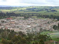
52:View of Cumbal
51:
43:
42:
36:
33:
32:
29:
22:
18:Cumbal Volcano
13:
10:
9:
6:
4:
3:
2:
1278:
1267:
1264:
1263:
1261:
1247:
1237:
1234:
1232:
1229:
1227:
1224:
1222:
1219:
1217:
1214:
1212:
1209:
1207:
1204:
1202:
1201:Santa Barbara
1199:
1197:
1194:
1192:
1189:
1187:
1184:
1182:
1179:
1177:
1174:
1172:
1169:
1167:
1166:Roberto Payán
1164:
1162:
1159:
1157:
1154:
1152:
1149:
1147:
1144:
1142:
1139:
1137:
1134:
1132:
1131:
1127:
1125:
1122:
1120:
1119:Olaya Herrera
1117:
1115:
1112:
1110:
1107:
1105:
1102:
1100:
1097:
1095:
1092:
1090:
1087:
1085:
1082:
1080:
1077:
1075:
1072:
1070:
1067:
1065:
1062:
1060:
1057:
1055:
1052:
1050:
1047:
1045:
1042:
1040:
1037:
1035:
1032:
1030:
1027:
1025:
1022:
1020:
1017:
1015:
1012:
1010:
1007:
1005:
1002:
1000:
997:
995:
992:
990:
987:
985:
982:
980:
977:
975:
972:
970:
967:
965:
962:
959:
956:
954:
951:
949:
946:
944:
941:
939:
936:
934:
931:
929:
926:
924:
921:
919:
916:
915:
912:
908:
900:
895:
893:
888:
886:
881:
880:
877:
858:
854:
848:
845:
833:
827:
824:
817:
815:
811:
807:
803:
800:
796:
790:
788:
785:
779:
777:
774:
771:
765:
758:
753:
749:
746:
743:
740:
737:
734:
731:
728:
725:
722:
719:
716:
713:
711:
706:
702:
699:
696:
693:
690:
687:
684:
681:
678:
675:
672:
669:
666:
664:
661:Mean monthly
659:
655:
652:
649:
646:
643:
640:
637:
634:
631:
628:
625:
622:
619:
616:
611:
607:
604:
601:
598:
595:
592:
589:
586:
583:
580:
577:
574:
571:
567:
561:
556:
551:
546:
541:
536:
531:
526:
521:
516:
511:
506:
501:
498:
497:precipitation
493:
487:
482:
477:
472:
467:
462:
457:
452:
447:
442:
437:
432:
427:
423:
417:
412:
407:
402:
397:
392:
387:
382:
377:
372:
367:
362:
357:
353:
347:
342:
337:
332:
327:
322:
317:
312:
307:
302:
297:
292:
287:
283:
239:
235:
230:
226:
224:
220:
212:
210:
207:
198:
196:
192:
190:
186:
182:
173:
170:
168:
160:
148:
145:
143:
136:
125:
116:
88:Coordinates:
79:
64:
49:
39:
34:
27:
19:
1176:San Bernardo
1128:
983:
861:. Retrieved
857:the original
847:
835:. Retrieved
826:
812:
808:
804:
801:
797:
794:
786:
783:
775:
772:
769:
499:mm (inches)
222:
216:
205:
202:
193:
180:
179:
38:Municipality
1186:San Lorenzo
1146:Providencia
1099:Magüí Payán
1034:Guaitarilla
708:Mean daily
110: /
1236:Yacuanquer
1069:La Llanada
1064:La Florida
1004:El Rosario
818:References
780:Foundation
153:Population
142:Department
98:77°47′27″W
1231:Tuquerres
1216:Taminango
1206:Santacruz
1191:San Pablo
1171:Samaniego
1136:Policarpa
1094:Los Andes
1039:Gualmatán
1029:Guachucal
1009:El Tablón
994:El Charco
989:Cumbitara
969:Contadero
953:Chachagüí
938:Barbacoas
199:Geography
167:Time zone
95:0°54′28″N
1260:Category
1161:Ricaurte
1156:Pupiales
1109:Mosquera
1079:La Unión
1014:El Tambo
999:El Peñol
960:(Génova)
933:Arboleda
837:17 April
755:Source:
703:1,498.3
613:Average
564:(34.43)
495:Average
221:(Köppen
189:Colombia
135:Colombia
40:and town
1211:Sapuyes
1181:Sandona
1151:Puerres
1104:Mallama
1089:Linares
1074:La Tola
1059:La Cruz
1054:Ipiales
979:Cuaspud
974:Córdoba
964:Consaca
948:Buesaco
863:17 June
559:(3.83)
554:(3.97)
549:(3.34)
544:(1.68)
539:(1.25)
534:(1.59)
529:(2.02)
524:(3.25)
519:(4.02)
514:(3.75)
509:(2.82)
504:(2.91)
490:(42.4)
485:(43.2)
480:(43.2)
475:(42.1)
470:(40.3)
465:(40.3)
460:(41.2)
455:(42.8)
450:(43.9)
445:(43.9)
440:(43.5)
435:(42.8)
430:(42.4)
420:(51.8)
415:(52.3)
410:(52.5)
405:(52.0)
400:(50.9)
395:(50.0)
390:(50.0)
385:(51.1)
380:(52.3)
375:(52.5)
370:(52.5)
365:(52.3)
360:(52.2)
350:(60.8)
345:(61.9)
340:(62.4)
335:(62.2)
330:(60.6)
325:(58.8)
320:(58.3)
315:(59.2)
310:(60.8)
305:(61.5)
300:(61.3)
295:(61.5)
290:(61.3)
213:Climate
123:Country
1226:Tumaco
1221:Tangua
1141:Potosí
1124:Ospina
1114:Nariño
984:Cumbal
928:Ancuya
923:Aldana
766:Limits
700:130.2
697:123.0
694:130.2
691:129.0
688:139.5
685:139.5
682:129.0
679:127.1
676:111.0
670:107.3
667:133.3
241:Month
206:paramo
181:Cumbal
161:41,205
132:
30:Cumbal
1130:Pasto
1084:Leiva
1049:Imués
1024:Funes
958:Colón
943:Belén
918:Albán
673:99.2
562:874.6
552:100.9
517:102.1
280:Year
172:UTC-5
1044:Iles
865:2024
839:2020
750:4.1
747:4.2
744:4.1
741:4.2
738:4.3
735:4.5
732:4.5
729:4.3
726:4.1
723:3.7
720:3.2
717:3.8
714:4.3
617:(%)
608:236
557:97.2
547:84.9
542:42.6
537:31.7
532:40.5
527:51.4
522:82.5
512:95.2
507:71.7
502:73.9
418:11.0
413:11.3
408:11.4
403:11.1
398:10.5
393:10.0
388:10.0
383:10.6
378:11.3
373:11.4
368:11.4
363:11.3
358:11.2
348:16.0
343:16.6
338:16.9
333:16.8
328:15.9
323:14.9
318:14.6
313:15.1
308:16.0
303:16.4
298:16.3
293:16.4
288:16.3
277:Dec
274:Nov
271:Oct
268:Sep
265:Aug
262:Jul
259:Jun
256:May
253:Apr
250:Mar
247:Feb
244:Jan
67:Flag
656:83
653:84
650:83
647:82
644:81
641:82
638:84
635:85
632:85
629:85
626:84
623:83
620:83
605:21
602:20
599:19
596:17
593:18
590:20
587:22
584:22
581:21
578:20
575:18
572:19
488:5.8
483:6.2
478:6.2
473:5.6
468:4.6
463:4.6
458:5.1
453:6.0
448:6.6
443:6.6
438:6.4
433:6.0
428:5.8
223:Cfb
1262::
191:.
187:,
898:e
891:t
884:v
867:.
841:.
20:.
Text is available under the Creative Commons Attribution-ShareAlike License. Additional terms may apply.