75:
441:
90:
557:
63:
281:, located in the center of the country. With a surface area of 756.19 square kilometres (291.97 sq mi), it is El Salvador's smallest department. It is inhabited by over 252,000 people. Cuscatlán or Cuzcatlán was the name the original inhabitants of the Western part of the country gave to most of the territory that is now El Salvador. In their language it means "land of precious jewels". It was created on 22 May 1835.
725:
141:
752:
626:
822:
429:
793:
216:
827:
619:
103:
193:
422:
74:
832:
666:
289:
was made the capital. It is known in producing fruits, tobacco, sugar cane, and coffee among other items. The department is famous for its
817:
686:
612:
786:
812:
415:
671:
89:
407:
506:
501:
402:
350:
345:
779:
635:
573:
274:
53:
526:
496:
370:
340:
646:
486:
330:
691:
656:
546:
481:
471:
390:
325:
315:
711:
696:
676:
578:
516:
360:
240:
681:
651:
706:
701:
531:
511:
375:
355:
730:
536:
380:
583:
521:
365:
269:
556:
62:
763:
491:
335:
806:
593:
253:
759:
588:
476:
456:
320:
286:
278:
170:
146:
751:
720:
604:
236:
118:
105:
541:
385:
282:
231:
31:
248:
17:
290:
285:
was the first capital of the department but on 12 November 1861,
608:
411:
555:
767:
566:
464:
247:
230:
222:
212:
204:
199:
189:
181:
176:
166:
152:
134:
44:
787:
620:
423:
8:
823:States and territories established in 1835
794:
780:
627:
613:
605:
430:
416:
408:
88:
41:
246:
229:
198:
185:756.19 km (291.97 sq mi)
175:
165:
151:
133:
98:
86:
68:
59:
268:
221:
211:
203:
188:
180:
7:
748:
746:
828:1835 establishments in El Salvador
25:
750:
723:
439:
157:(given current status)
139:
73:
61:
293:from the city of Cojutepeque.
30:For pre-Columbian polity, see
1:
766:. You can help Knowledge by
833:El Salvador geography stubs
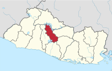
94:Location within El Salvador
849:
818:Departments of El Salvador
745:
636:Departments of El Salvador
29:
718:
642:
553:
452:
99:
87:
69:
60:
51:
39:Department in El Salvador
27:Department of El Salvador
574:Cerrón Grande Reservoir
502:San Bartolomé Perulapía
346:San Bartolomé Perulapía
226:330/km (860/sq mi)
762:location article is a
560:
497:Oratorio de Concepción
403:El Salvador at GeoHive
341:Oratorio de Concepción
266:Spanish pronunciation:
559:
813:Cuscatlán Department
532:Santa Cruz Analquito
446:Cuscatlán Department
376:Santa Cruz Analquito
270:[kuskaˈtlan]
223: • Density
579:Cuscatlán Formation
517:San Pedro Perulapán
361:San Pedro Perulapán
115: /
731:El Salvador portal
561:
537:Santa Cruz Michapa
381:Santa Cruz Michapa
205: • Total
182: • Total
775:
774:
740:
739:
602:
601:
522:San Rafael Cedros
512:San José Guayabal
366:San Rafael Cedros
356:San José Guayabal
259:
258:
213: • Rank
190: • Rank
119:13.838°N 89.031°W
16:(Redirected from
840:
796:
789:
782:
754:
747:
733:
728:
727:
726:
629:
622:
615:
606:
444:
443:
442:
432:
425:
418:
409:
272:
267:
159:
158:
145:
143:
142:
130:
129:
127:
126:
125:
120:
116:
113:
112:
111:
108:
92:
77:
65:
42:
21:
848:
847:
843:
842:
841:
839:
838:
837:
803:
802:
801:
800:
743:
741:
736:
729:
724:
722:
716:
638:
633:
603:
598:
584:Guazapa Volcano
562:
551:
460:
448:
440:
438:
436:
399:
312:
302:Cuscatlán Norte
299:
265:
156:
155:
154:
140:
138:
124:13.838; -89.031
123:
121:
117:
114:
109:
106:
104:
102:
101:
95:
83:
82:
81:
80:
56:
47:
40:
35:
28:
23:
22:
15:
12:
11:
5:
846:
844:
836:
835:
830:
825:
820:
815:
805:
804:
799:
798:
791:
784:
776:
773:
772:
755:
738:
737:
735:
734:
719:
717:
715:
714:
709:
704:
699:
694:
689:
684:
679:
674:
669:
664:
659:
654:
649:
643:
640:
639:
634:
632:
631:
624:
617:
609:
600:
599:
597:
596:
591:
586:
581:
576:
570:
568:
564:
563:
554:
552:
550:
549:
544:
539:
534:
529:
524:
519:
514:
509:
504:
499:
494:
492:Monte San Juan
489:
484:
479:
474:
468:
466:
465:Municipalities
462:
461:
453:
450:
449:
437:
435:
434:
427:
420:
412:
406:
405:
398:
395:
394:
393:
388:
383:
378:
373:
368:
363:
358:
353:
348:
343:
338:
336:Monte San Juan
333:
328:
323:
318:
311:
308:
307:
306:
303:
298:
297:Municipalities
295:
257:
256:
251:
245:
244:
234:
228:
227:
224:
220:
219:
214:
210:
209:
206:
202:
201:
197:
196:
191:
187:
186:
183:
179:
178:
174:
173:
168:
164:
163:
160:
150:
149:
136:
132:
131:
97:
96:
93:
85:
84:
78:
72:
71:
70:
67:
66:
58:
57:
52:
49:
48:
45:
38:
26:
24:
14:
13:
10:
9:
6:
4:
3:
2:
845:
834:
831:
829:
826:
824:
821:
819:
816:
814:
811:
810:
808:
797:
792:
790:
785:
783:
778:
777:
771:
769:
765:
761:
756:
753:
749:
744:
732:
721:
713:
710:
708:
705:
703:
700:
698:
695:
693:
690:
688:
685:
683:
680:
678:
675:
673:
670:
668:
665:
663:
660:
658:
655:
653:
650:
648:
645:
644:
641:
637:
630:
625:
623:
618:
616:
611:
610:
607:
595:
594:Lake Ilopango
592:
590:
587:
585:
582:
580:
577:
575:
572:
571:
569:
565:
558:
548:
545:
543:
540:
538:
535:
533:
530:
528:
525:
523:
520:
518:
515:
513:
510:
508:
507:San Cristóbal
505:
503:
500:
498:
495:
493:
490:
488:
485:
483:
480:
478:
475:
473:
470:
469:
467:
463:
459:
458:
451:
447:
433:
428:
426:
421:
419:
414:
413:
410:
404:
401:
400:
396:
392:
389:
387:
384:
382:
379:
377:
374:
372:
369:
367:
364:
362:
359:
357:
354:
352:
351:San Cristóbal
349:
347:
344:
342:
339:
337:
334:
332:
329:
327:
324:
322:
319:
317:
314:
313:
309:
305:Cuscatlán Sur
304:
301:
300:
296:
294:
292:
288:
284:
280:
276:
271:
263:
255:
252:
250:
249:ISO 3166 code
242:
238:
235:
233:
225:
218:
215:
207:
195:
192:
184:
172:
169:
161:
148:
137:
128:
100:Coordinates:
91:
76:
64:
55:
50:
43:
37:
33:
19:
768:expanding it
757:
742:
692:San Salvador
661:
657:Chalatenango
455:
445:
261:
260:
36:
760:El Salvador
697:San Vicente
667:La Libertad
589:Jiboa River
477:Cojutepeque
457:Cojutepeque
321:Cojutepeque
287:Cojutepeque
279:El Salvador
217:Ranked 12th
194:Ranked 14th
171:Cojutepeque
147:El Salvador
122: /
807:Categories
687:San Miguel
647:Ahuachapán
547:Tenancingo
487:El Rosario
472:Candelaria
397:References
391:Tenancingo
331:El Rosario
316:Candelaria
275:department
200:Population
110:89°01′52″W
107:13°50′17″N
54:Department
707:Sonsonate
702:Santa Ana
662:Cuscatlán
567:Geography
542:Suchitoto
527:San Ramón
482:El Carmen
454:Capital:
386:Suchitoto
371:San Ramón
326:El Carmen
310:Districts
283:Suchitoto
262:Cuscatlán
232:Time zone
46:Cuscatlán
32:Cuzcatlan
18:Cuscatlán
712:Usulután
677:La Unión
291:chorizos
682:Morazán
652:Cabañas
273:) is a
208:252,528
153:Created
135:Country
672:La Paz
144:
758:This
254:SV-CU
237:UTC−6
764:stub
177:Area
167:Seat
162:1835
79:Flag
277:of
241:CST
809::
795:e
788:t
781:v
770:.
628:e
621:t
614:v
431:e
424:t
417:v
264:(
243:)
239:(
34:.
20:)
Text is available under the Creative Commons Attribution-ShareAlike License. Additional terms may apply.