273:
28:
116:
123:
280:
The panorama from the hill is considered to have "commanding views towards the
Pennines and Tyne Valley to the West, the Cheviot Hills to the North with Tyneside and North Sea Coast to the East." The county top itself is ambiguously situated on an arable feed directly south of the Lead Road.
300:
More recently, the northern part of the hill has been used as the location for the
Northumbria Gliding Club. The club has a variety of aircraft including three dual seat gliders, a single seat
289:
There has been a long association with flying on
Currock Hill: during the First World War an area on the southern flank of the hill was designated as a relief airfield or landing ground for
513:
172:
528:
216:. Although the summit itself lies entirely within Northumberland, the eastern top (at 259 m, or 850 ft) is the highest point in both Tyne and Wear and the
115:
316:
58:
533:
72:
424:
396:
369:
266:
272:
27:
467:
297:. It was a Home Defence squadron, and patrolled the coastal area around Newcastle to prevent attacks by German Zeppelins.
166:
65:
386:
227:
The name ‘currock’ comes from the Celtic word for a cairn or a stack of stones, a development of the word for a rock,
359:
294:
488:
217:
290:
258:
250:
234:
155:
53:
420:
392:
365:
471:
412:
305:
301:
185:
180:
336:
254:
205:
522:
209:
136:
464:
262:
87:
74:
261:. The hill forms part of the watershed divide between the catchments of the
221:
388:
Goodwife Hot, and others: Northumberland's past as shown in its place names
246:
151:
443:
213:
159:
43:
271:
228:
201:
361:
The UK's County Tops: Reaching the top of 91 historic counties
489:"North East Aviation Research – Currock Hill Landing Ground"
308:
tug planes, all of which use the grass runway at the site.
179:
165:
147:
103:
64:
52:
42:
37:
20:
465:"Royal Air Force Historic Squadrons: 36 Squadron"
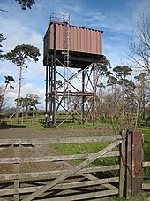
276:Currock Hill water tower (Northumberland summit)
293:of the Royal Flying Corps, which was based at
419:. OS Landranger Map Series. Ordnance Survey.
8:
17:
438:
436:
317:List of English counties by highest point
327:
245:It is situated between the villages of
514:Map of Currock Hill - Streetmap.co.uk
7:
339:. The Mountains of England and Wales
122:
529:Highest points of English counties
233:, and is still widely used in the
14:
121:
114:
26:
534:Mountains and hills of England
1:
550:
446:. northumbriagliding.co.uk
444:"Northumbria Gliding Club"
478:. Retrieved 10 June 2013.
108:
25:
385:Watson, Godfrey (1970).
48:259 m (850 ft)
335:Simon Edwardes (2001).
229:
337:"Historic County Tops"
277:
204:on the border between
275:
265:to the north and the
253:, on the border with
358:Muir, Jonny (2011).
218:metropolitan borough
259:Newcastle upon Tyne
84: /
470:2016-11-21 at the
278:
251:Hedley on the Hill
156:Hedley on the Hill
88:54.9275°N 1.8343°W
38:Highest point
195:
194:
32:Currock Hill Farm
541:
501:
500:
498:
496:
485:
479:
462:
456:
455:
453:
451:
440:
431:
430:
409:
403:
402:
382:
376:
375:
355:
349:
348:
346:
344:
332:
232:
175:
135:Currock Hill in
125:
124:
118:
99:
98:
96:
95:
94:
93:54.9275; -1.8343
89:
85:
82:
81:
80:
77:
30:
18:
549:
548:
544:
543:
542:
540:
539:
538:
519:
518:
510:
505:
504:
494:
492:
491:. nelsam.org.uk
487:
486:
482:
476:Royal Air Force
472:Wayback Machine
463:
459:
449:
447:
442:
441:
434:
427:
413:Ordnance Survey
411:
410:
406:
399:
391:. Oriel Press.
384:
383:
379:
372:
357:
356:
352:
342:
340:
334:
333:
329:
324:
314:
306:Aeropro Eurofox
287:
257:to the west of
243:
171:
143:
142:
141:
140:
139:
133:
132:
131:
130:
126:
92:
90:
86:
83:
78:
75:
73:
71:
70:
33:
12:
11:
5:
547:
545:
537:
536:
531:
521:
520:
517:
516:
509:
508:External links
506:
503:
502:
480:
457:
432:
425:
404:
397:
377:
370:
350:
326:
325:
323:
320:
313:
310:
291:No.36 Squadron
286:
283:
269:to the south.
255:Northumberland
242:
239:
206:Northumberland
193:
192:
183:
177:
176:
173:NZ 10717 59214
169:
163:
162:
149:
145:
144:
134:
128:
127:
120:
119:
113:
112:
111:
110:
109:
106:
105:
101:
100:
68:
62:
61:
56:
50:
49:
46:
40:
39:
35:
34:
31:
23:
22:
13:
10:
9:
6:
4:
3:
2:
546:
535:
532:
530:
527:
526:
524:
515:
512:
511:
507:
490:
484:
481:
477:
473:
469:
466:
461:
458:
445:
439:
437:
433:
428:
426:9780319229989
422:
418:
414:
408:
405:
400:
398:9780853620907
394:
390:
389:
381:
378:
373:
371:9781849655538
367:
363:
362:
354:
351:
338:
331:
328:
321:
319:
318:
311:
309:
307:
303:
298:
296:
292:
284:
282:
274:
270:
268:
264:
260:
256:
252:
248:
240:
238:
236:
231:
225:
223:
219:
215:
211:
210:Tyne and Wear
207:
203:
199:
190:
187:
184:
182:
178:
174:
170:
168:
164:
161:
157:
153:
150:
146:
138:
137:Tyne and Wear
117:
107:
102:
97:
69:
67:
63:
60:
57:
55:
51:
47:
45:
41:
36:
29:
24:
19:
16:
493:. Retrieved
483:
475:
460:
448:. Retrieved
417:88 Newcastle
416:
407:
387:
380:
364:. Cicerone.
360:
353:
341:. Retrieved
330:
315:
299:
288:
279:
244:
226:
198:Currock Hill
197:
196:
188:
129:Currock Hill
21:Currock Hill
15:
295:Cramlington
91: /
66:Coordinates
523:Categories
322:References
302:Astir CS77
263:River Tyne
235:North East
189:Landranger
76:54°55′39″N
59:County Top
241:Geography
222:Gateshead
104:Geography
79:1°50′03″W
44:Elevation
468:Archived
415:(2012).
312:See also
304:and two
247:Chopwell
181:Topo map
152:Chopwell
148:Location
495:10 June
450:17 June
343:28 June
267:Derwent
214:England
167:OS grid
160:England
54:Listing
423:
395:
368:
285:Flying
230:carroc
200:is a
497:2013
452:2021
421:ISBN
393:ISBN
366:ISBN
345:2013
249:and
208:and
202:hill
154:and
220:of
525::
474:.
435:^
237:.
224:.
212:,
191:88
186:OS
158:,
499:.
454:.
429:.
401:.
374:.
347:.
Text is available under the Creative Commons Attribution-ShareAlike License. Additional terms may apply.