498:(130 mph); at the time, the agency anticipated further strengthening due to the favorable conditions and good organization. At 18:00 UTC on October 28, the IMD estimated peak 3-minute winds of 205 km/h (125 mph). At the time, it was the third-strongest storm on record in the Arabian Sea. On October 29, Nilofar started weakening due to increased wind shear, and the convection diminished in intensity. At the same time, the storm turned northeastward while rounding the ridge to the east. Increasingly cooler and drier air, as well as cooler waters, caused the storm to degrade rapidly. The eye, previously small and well defined, dissipated by 06:00 UTC on October 29. Later that day, the center began decoupling from the convection, a sign of rapid weakening, and by 21:00 UTC the IMD downgraded it to a severe cyclonic storm. Early on October 30, the JTWC downgraded Nilofar to a tropical storm, and subsequently the circulation became exposed from the convection. At 18:00 UTC that day, the JTWC posted their final advisory. Nilofar weakened further into a depression on October 31, and soon after degenerated into a remnant low off coast of the Indian state of
540:, helping the state record its wettest October in four years. Other nearby areas along India's west coast received heavy rainfall. The threat of the storm prompted officials to evacuate nearly 30,000 people in western India, utilizing 200 storm shelters. Most of the displaced people were living in thatched huts and weak structures. In coastal areas, schools were canceled for two days. Most of the evacuees quickly returned home after the storm weakened. To minimize damage, trees were trimmed down to eliminate damage due to falling debris, and a total suspension of fishing activities was ordered, with about 5,000 boats advised to return to port. Officials in Gujarat sent a warning of the storm to all operators of
640:
1699:
195:
511:
29:
1812:
371:
302:
381:
391:
596:
in
October, mobile companies enacted greater preparations during Nilofar to guarantee operations during the storm, including an emergency hotline, setting up internet in shelters, and mobile cell towers. Despite the threat from the storm, Nilofar only produced light rainfall and gusty winds along the
481:
at 21:00 UTC. At 00:00 UTC on
October 27, the JTWC upgraded Nilofar to the equivalent of a minimal hurricane, based on the development of a 54 km (33 mi) eye. Throughout that day, the cyclone turned more to the northwest as a ridge built to the east, while the inner core of
476:
to the south, although the motion slowed on
October 26 due to competing influence of another subtropical ridge to the northwest. That day, the system strengthened quickly; the IMD upgraded the depression to a deep depression at 03:00 UTC, to Cyclonic Storm Nilofar at 06:00 UTC, and
497:
at the time, after the wind shear had decreased, and the eye contracted to a diameter of 19 km (12 mi). At 09:00 UTC on
October 28, the IMD upgraded Nilofar further to an extremely severe cyclonic storm. Six hours later, the JTWC estimated peak 1-minute winds of 215 km/h
468:. Moderate wind shear and continued interaction with the monsoon dislocated the bulk of the deepest convection to the western periphery. By 12:00 UTC on October 25, the system organized enough for the JTWC to classify it as Tropical Cyclone 04A, and there were hints of an
1678:
1664:
1228:
1202:
1176:
1150:
1124:
1098:
1072:
1024:
973:
947:
921:
895:
869:
811:
785:
1452:
601:, causing prices to rise. Shifting air patterns brought cooler temperatures to western India, signaling the end of the monsoon season, while also bringing haze and smog over
1412:
840:
1836:
1815:
1846:
1364:
273:. It developed into a depression on October 25 and moved generally northward through an area of favorable conditions. The system intensified into a
218:
1841:
521:
Offshore buoys recorded 3.2 m (10.5 ft) waves and winds of 41 km/h (25 mph). The outskirts of the storm caused flash flooding in
687:
in 2015 for storms with winds of 167 to 221 km/h (104 to 137 mph); such intensity was previously considered a Very Severe
Cyclonic Storm.
1671:
1615:
1549:
1797:
1761:
1749:
1737:
1725:
1713:
1688:
205:
1438:
760:
464:
When the system first formed, it benefited from warm water temperatures of 28 to 30 °C (82 to 86 °F) and a favorable phase of the
1523:
1851:
1589:
1498:
514:
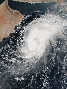
Cyclone
Nilofar succumbing to strong wind shear on October 30. Note part of the low-level circulation exposed on the west side of the
247:
289:
caused the storm to rapidly weaken, and
Nilofar degraded into a remnant low-pressure area on October 31 off the Indian state of
617:
1646:
1343:
553:
680:
483:
454:
230:
73:
589:
465:
844:
446:
1698:
1575:
449:(JTWC) classified it as a tropical depression, although the agency did not issue warnings at the time. At 00:00
608:
In
Pakistan, fishermen were also warned to avoid the sea, and people in coastal areas were evacuated. The country's
450:
1656:
238:
1274:
315:
121:
645:
472:
within the thunderstorms. By the time of classification, the storm was moving to the northeast, steered by the
422:
532:
In the storm's developmental stages, the outskirts of
Nilofar dropped 410 mm (16 in) of rainfall in
493:
At 06:00 UTC on
October 27, the IMD upgraded Nilofar to a very severe cyclonic storm. The storm was
999:
684:
478:
274:
234:
515:
281:
and structure, attaining its peak intensity on October 28. At the time, Nilofar was expected to make
226:
494:
434:
430:
394:
708:
613:
1232:
1206:
1180:
1154:
1128:
1102:
1076:
1028:
977:
951:
925:
899:
873:
815:
789:
384:
190:
624:
province, bathing and swimming were banned for several days. There were minor power outages in
277:
on October 26. Quickly organizing due to the conditions, Nilofar developed a well-defined
473:
418:
270:
262:
620:, and fishermen organizations helped rescue fishermen stationed offshore. Along the coast of
374:
441:
to its east-northeast. The structure became more organized by October 24, when broken
1650:
1050:
659:
510:
457:(IMD) classified the system as a depression about 1270 km (790 mi) southeast of
194:
150:
102:
28:
1643:
529:. Five people were rescued when another car was stranded amid floods west of Al-Rustaq.
1773:
593:
406:
525:
in northeastern Oman, killing four people after a vehicle was swept away in a flooded
1830:
1390:
1318:
609:
541:
469:
278:
229:
estimated between 205 km/h (125 mph) and 215 km/h (130 mph). The
142:
94:
653:
458:
417:
archipelago, remaining nearly stationary for several days. It developed a distinct
305:
Map plotting the storm's track and intensity, according to the Saffir–Simpson scale
301:
1453:"Cyclone Nilofar: NDRF pre-positioning teams in Gujarat, DoT announces measures"
598:
445:
were rotating around a poorly-defined circulation. That day, the American-based
438:
414:
410:
251:
222:
635:
557:
426:
413:
off the west coast of India. A circulation formed on October 19 near the
286:
146:
98:
581:
565:
522:
486:
anticipated that Nilofar would eventually recurve to the northeast and make
585:
487:
442:
282:
243:
766:(Report). India Meteorological Department. February 2015. pp. 87–97
285:
in western India, prompting evacuations and preparations. However, high
625:
569:
499:
290:
662:– second-strongest tropical cyclone on record in the Arabian Sea
573:
561:
549:
545:
533:
1000:
Joint Session of Panel on Tropical Cyclones & Typhoon Committee
482:
convection became more symmetrical and compact. Also by that time,
621:
602:
509:
300:
266:
1344:"Cyclone Nilofar: Severe storm to hit Gujarat on Oct 31 morning"
1231:. Joint Typhoon Warning Center. October 30, 2014. Archived from
1205:. Joint Typhoon Warning Center. October 30, 2014. Archived from
1179:. Joint Typhoon Warning Center. October 30, 2014. Archived from
1153:. Joint Typhoon Warning Center. October 29, 2014. Archived from
1127:. Joint Typhoon Warning Center. October 29, 2014. Archived from
1101:. Joint Typhoon Warning Center. October 29, 2014. Archived from
1075:. Joint Typhoon Warning Center. October 29, 2014. Archived from
1027:. Joint Typhoon Warning Center. October 27, 2014. Archived from
976:. Joint Typhoon Warning Center. October 27, 2014. Archived from
950:. Joint Typhoon Warning Center. October 27, 2014. Archived from
924:. Joint Typhoon Warning Center. October 27, 2014. Archived from
898:. Joint Typhoon Warning Center. October 26, 2014. Archived from
872:. Joint Typhoon Warning Center. October 25, 2014. Archived from
814:. Joint Typhoon Warning Center. October 24, 2014. Archived from
788:. Joint Typhoon Warning Center. October 22, 2014. Archived from
577:
526:
255:
182:
1660:
656:– strongest tropical cyclone on record in the Arabian Sea
1413:"Shortage of Ham radio operators in Andhra Pradesh, Telangana"
1365:"Gujarat heaves sigh of relief as cyclone Nilofar fizzles out"
537:
843:. Joint Typhoon Warning Center. June 11, 2015. Archived from
1590:"Cyclone Nilofar: Sindh coastal belt closed till November 2"
1439:"NDRF positions teams as 'Nilofar' approaches Gujarat coast"
1296:"Hudhud, Nilofar give Goa its wettest October in 4 years".
329:
Tropical storm (39–73 mph, 63–118 km/h)
324:
Tropical depression (≤38 mph, ≤62 km/h)
397:, remnant low, tropical disturbance, or monsoon depression
349:
Category 4 (130–156 mph, 209–251 km/h)
344:
Category 3 (111–129 mph, 178–208 km/h)
544:. A distant warning signal 2 was hoisted in the ports of
339:
Category 2 (96–110 mph, 154–177 km/h)
1616:"K-Electric's 120 feeders trip as first rains lash city"
761:
WMO/ESCAP Panel on Tropical Cyclones: Annual Review 2014
597:
Gujarat coast. Unseasonable rainfall damaged mangoes in
334:
Category 1 (74–95 mph, 119–153 km/h)
1275:"Cyclone Nilofar is Oman's new meteorological nemesis"
1478:"Telcos better prepared to tackle Cyclone Nilofar".
841:"Best Track Data for Tropical Cyclone 04A (Nilofar)"
421:
on October 21, and produced an intense area of
354:
Category 5 (≥157 mph, ≥252 km/h)
178:
170:
162:
157:
136:
128:
109:
88:
80:
61:
53:
45:
38:
33:
Nilofar shortly before peak intensity on October 28
1391:"Cyclone Nilofar approaches India's Gujarat state"
1319:"India's Gujarat state braces for Cyclone Nilofar"
1005:(Report). World Meteorological Organization. 2015
707:Tooba Masood; Sameer Mandhro (October 30, 2014).
1229:"Tropical Cyclone 04A (Nilofar) Warning NR 022"
1203:"Tropical Cyclone 04A (Nilofar) Warning NR 021"
1177:"Tropical Cyclone 04A (Nilofar) Warning NR 019"
1151:"Tropical Cyclone 04A (Nilofar) Warning NR 018"
1125:"Tropical Cyclone 04A (Nilofar) Warning NR 016"
1099:"Tropical Cyclone 04A (Nilofar) Warning NR 017"
1073:"Tropical Cyclone 04A (Nilofar) Warning NR 015"
1025:"Tropical Cyclone 04A (Nilofar) Warning NR 013"
974:"Tropical Cyclone 04A (Nilofar) Warning NR 010"
948:"Tropical Cyclone 04A (Nilofar) Warning NR 008"
922:"Tropical Cyclone 04A (Nilofar) Warning NR 007"
1672:
433:, including warm water temperatures and good
8:
896:"Tropical Cyclone 04A (Four) Warning NR 003"
870:"Tropical Cyclone 04A (Four) Warning NR 001"
556:deployed rescue and rehabilitation teams at
21:
1679:
1665:
1657:
1254:"Flash flood toll in Oman rises to four".
1053:. NASA Earth Observatory. November 2, 2014
250:. The western fringes of the storm caused
193:
27:
20:
1550:"Haze in Delhi due to agri-waste burning"
1499:"Showers to Rain on Mango Lovers' Parade"
1359:
1357:
1313:
1311:
225:. In late October 2014, it reached peak
1653:from the U.S. Naval Research Laboratory
812:"Significant Tropical Weather Advisory"
786:"Significant Tropical Weather Advisory"
699:
672:
405:Toward the middle of October 2014, the
215:Extremely Severe Cyclonic Storm Nilofar
22:Extremely Severe Cyclonic Storm Nilofar
1837:2014 North Indian Ocean cyclone season
1689:2014 North Indian Ocean cyclone season
1338:
1336:
755:
753:
751:
749:
580:while standby teams were stationed at
206:2014 North Indian Ocean cyclone season
111:Category 4-equivalent tropical cyclone
1576:"Pakistan braces for cyclone Nilofar"
747:
745:
743:
741:
739:
737:
735:
733:
731:
729:
7:
1524:"Cool weather sets in, winter ahead"
835:
833:
709:"Cyclone Nilofar: What's in a name?"
628:due to heavy rainfall from Nilofar.
1784:
1779:
605:from polluting areas to the south.
1772:
1767:
1484: – via Lexis Nexis
1302: – via Lexis Nexis
1273:Basel Ismaiel (November 1, 2014).
1260: – via Lexis Nexis
425:by the next day. Despite moderate
14:
1847:History of Gujarat (1947–present)
1760:
1755:
618:Pakistan Maritime Security Agency
1842:Extremely severe cyclonic storms
1811:
1810:
1796:
1791:
1748:
1743:
1736:
1731:
1697:
1594:The News International, Pakistan
638:
554:National Disaster Response Force
484:tropical cyclone forecast models
389:
379:
369:
1724:
1719:
1712:
1707:
685:Extremely Severe Cyclonic Storm
681:India Meteorological Department
588:. After facing problems during
455:India Meteorological Department
231:India Meteorological Department
63:Extremely severe cyclonic storm
1497:Sandip Dighe (March 2, 2015).
1:
1441:. Zee News. October 28, 2014.
429:, conditions favored further
1393:. BBC News. October 27, 2014
1321:. BBC News. October 30, 2014
683:implemented the category of
447:Joint Typhoon Warning Center
217:was, at the time, the third-
132:215 km/h (130 mph)
84:205 km/h (125 mph)
16:North Indian cyclone in 2014
1868:
261:Nilofar originated from a
1852:Tropical cyclones in 2014
1806:
1704:
1695:
1687:Tropical cyclones of the
466:Madden–Julian oscillation
242:; the name refers to the
201:
189:
116:
68:
26:
1578:. DNA. October 28, 2014.
646:Tropical cyclones portal
453:on October 25, the
1486:(subscription required)
1304:(subscription required)
1262:(subscription required)
506:Preparations and impact
258:, killing four people.
246:, and was suggested by
227:maximum sustained winds
518:
516:central dense overcast
402:
297:Meteorological history
40:Meteorological history
513:
479:severe cyclonic storm
395:Extratropical cyclone
304:
495:rapidly intensifying
409:was active over the
316:Saffir–Simpson scale
137:Lowest pressure
89:Lowest pressure
1482:. October 31, 2014.
1350:. October 27, 2014.
1300:. November 4, 2014.
1258:. November 1, 2014.
713:The Express Tribune
385:Subtropical cyclone
23:
1649:2021-09-22 at the
1622:. November 1, 2014
1596:. October 27, 2014
1556:. October 31, 2014
1554:The Times of India
1530:. November 1, 2014
1528:The Times of India
1480:The Economic Times
1459:. October 27, 2014
1457:The Times of India
1419:. November 2, 2014
1417:The Times of India
1371:. October 31, 2014
1369:The Times of India
1348:The Indian Express
519:
490:in western India.
437:, amplified by an
403:
129:Highest winds
118:1-minute sustained
81:Highest winds
70:3-minute sustained
1824:
1823:
1051:"Cyclone Nilofar"
592:in September and
474:subtropical ridge
419:low-pressure area
271:Arabian Peninsula
263:low-pressure area
219:strongest cyclone
212:
211:
185:, India, Pakistan
1859:
1814:
1813:
1794:
1782:
1770:
1758:
1746:
1734:
1722:
1710:
1701:
1681:
1674:
1667:
1658:
1632:
1631:
1629:
1627:
1612:
1606:
1605:
1603:
1601:
1586:
1580:
1579:
1572:
1566:
1565:
1563:
1561:
1546:
1540:
1539:
1537:
1535:
1520:
1514:
1513:
1511:
1509:
1494:
1488:
1487:
1483:
1475:
1469:
1468:
1466:
1464:
1449:
1443:
1442:
1435:
1429:
1428:
1426:
1424:
1409:
1403:
1402:
1400:
1398:
1387:
1381:
1380:
1378:
1376:
1361:
1352:
1351:
1340:
1331:
1330:
1328:
1326:
1315:
1306:
1305:
1301:
1293:
1287:
1286:
1284:
1282:
1270:
1264:
1263:
1259:
1251:
1245:
1244:
1242:
1240:
1225:
1219:
1218:
1216:
1214:
1199:
1193:
1192:
1190:
1188:
1173:
1167:
1166:
1164:
1162:
1147:
1141:
1140:
1138:
1136:
1121:
1115:
1114:
1112:
1110:
1095:
1089:
1088:
1086:
1084:
1069:
1063:
1062:
1060:
1058:
1047:
1041:
1040:
1038:
1036:
1021:
1015:
1014:
1012:
1010:
1004:
996:
990:
989:
987:
985:
970:
964:
963:
961:
959:
944:
938:
937:
935:
933:
918:
912:
911:
909:
907:
892:
886:
885:
883:
881:
866:
860:
859:
857:
855:
849:
837:
828:
827:
825:
823:
808:
802:
801:
799:
797:
782:
776:
775:
773:
771:
765:
757:
724:
723:
721:
719:
704:
688:
677:
648:
643:
642:
641:
393:
392:
383:
382:
375:Tropical cyclone
373:
372:
358:
353:
348:
343:
338:
333:
328:
323:
254:in northeastern
197:
153:
112:
105:
64:
57:October 31, 2014
49:October 25, 2014
41:
31:
24:
1867:
1866:
1862:
1861:
1860:
1858:
1857:
1856:
1827:
1826:
1825:
1820:
1802:
1801:
1800:
1795:
1792:
1789:
1788:
1783:
1780:
1777:
1776:
1771:
1768:
1765:
1764:
1759:
1756:
1753:
1752:
1747:
1744:
1741:
1740:
1735:
1732:
1729:
1728:
1723:
1720:
1717:
1716:
1711:
1708:
1702:
1691:
1685:
1651:Wayback Machine
1640:
1635:
1625:
1623:
1614:
1613:
1609:
1599:
1597:
1588:
1587:
1583:
1574:
1573:
1569:
1559:
1557:
1548:
1547:
1543:
1533:
1531:
1522:
1521:
1517:
1507:
1505:
1496:
1495:
1491:
1485:
1477:
1476:
1472:
1462:
1460:
1451:
1450:
1446:
1437:
1436:
1432:
1422:
1420:
1411:
1410:
1406:
1396:
1394:
1389:
1388:
1384:
1374:
1372:
1363:
1362:
1355:
1342:
1341:
1334:
1324:
1322:
1317:
1316:
1309:
1303:
1295:
1294:
1290:
1280:
1278:
1277:. Green Prophet
1272:
1271:
1267:
1261:
1253:
1252:
1248:
1238:
1236:
1235:on May 22, 2024
1227:
1226:
1222:
1212:
1210:
1209:on May 22, 2024
1201:
1200:
1196:
1186:
1184:
1183:on May 22, 2024
1175:
1174:
1170:
1160:
1158:
1157:on May 22, 2024
1149:
1148:
1144:
1134:
1132:
1131:on May 22, 2024
1123:
1122:
1118:
1108:
1106:
1105:on May 22, 2024
1097:
1096:
1092:
1082:
1080:
1079:on May 22, 2024
1071:
1070:
1066:
1056:
1054:
1049:
1048:
1044:
1034:
1032:
1031:on May 22, 2024
1023:
1022:
1018:
1008:
1006:
1002:
998:
997:
993:
983:
981:
980:on May 22, 2024
972:
971:
967:
957:
955:
954:on May 22, 2024
946:
945:
941:
931:
929:
928:on May 22, 2024
920:
919:
915:
905:
903:
902:on May 22, 2024
894:
893:
889:
879:
877:
876:on May 22, 2024
868:
867:
863:
853:
851:
850:on June 2, 2017
847:
839:
838:
831:
821:
819:
818:on May 22, 2024
810:
809:
805:
795:
793:
792:on May 22, 2024
784:
783:
779:
769:
767:
763:
759:
758:
727:
717:
715:
706:
705:
701:
697:
692:
691:
678:
674:
669:
660:Cyclone Chapala
644:
639:
637:
634:
508:
401:
400:
399:
398:
390:
387:
380:
377:
370:
367:
361:
360:
356:
355:
351:
350:
346:
345:
341:
340:
336:
335:
331:
330:
326:
325:
321:
319:
310:
306:
299:
202:
158:Overall effects
140:
110:
92:
62:
39:
34:
17:
12:
11:
5:
1865:
1863:
1855:
1854:
1849:
1844:
1839:
1829:
1828:
1822:
1821:
1819:
1818:
1807:
1804:
1803:
1790:
1778:
1766:
1754:
1742:
1730:
1718:
1706:
1705:
1703:
1696:
1693:
1692:
1686:
1684:
1683:
1676:
1669:
1661:
1655:
1654:
1639:
1638:External links
1636:
1634:
1633:
1620:Pakistan Today
1607:
1581:
1567:
1541:
1515:
1489:
1470:
1444:
1430:
1404:
1382:
1353:
1332:
1307:
1298:Times of India
1288:
1265:
1246:
1220:
1194:
1168:
1142:
1116:
1090:
1064:
1042:
1016:
991:
965:
939:
913:
887:
861:
829:
803:
777:
725:
698:
696:
693:
690:
689:
671:
670:
668:
665:
664:
663:
657:
650:
649:
633:
630:
594:Cyclone Hudhud
507:
504:
407:monsoon trough
388:
378:
368:
363:
362:
320:
313:
312:
311:
308:
307:
298:
295:
275:cyclonic storm
252:flash flooding
210:
209:
199:
198:
187:
186:
180:
179:Areas affected
176:
175:
172:
168:
167:
164:
160:
159:
155:
154:
149:); 27.67
138:
134:
133:
130:
126:
125:
114:
113:
107:
106:
101:); 28.05
90:
86:
85:
82:
78:
77:
66:
65:
59:
58:
55:
51:
50:
47:
43:
42:
36:
35:
32:
15:
13:
10:
9:
6:
4:
3:
2:
1864:
1853:
1850:
1848:
1845:
1843:
1840:
1838:
1835:
1834:
1832:
1817:
1809:
1808:
1805:
1799:
1787:
1775:
1763:
1751:
1739:
1727:
1715:
1700:
1694:
1690:
1682:
1677:
1675:
1670:
1668:
1663:
1662:
1659:
1652:
1648:
1645:
1642:
1641:
1637:
1621:
1617:
1611:
1608:
1595:
1591:
1585:
1582:
1577:
1571:
1568:
1555:
1551:
1545:
1542:
1529:
1525:
1519:
1516:
1504:
1500:
1493:
1490:
1481:
1474:
1471:
1458:
1454:
1448:
1445:
1440:
1434:
1431:
1418:
1414:
1408:
1405:
1392:
1386:
1383:
1370:
1366:
1360:
1358:
1354:
1349:
1345:
1339:
1337:
1333:
1320:
1314:
1312:
1308:
1299:
1292:
1289:
1276:
1269:
1266:
1257:
1256:Times of Oman
1250:
1247:
1234:
1230:
1224:
1221:
1208:
1204:
1198:
1195:
1182:
1178:
1172:
1169:
1156:
1152:
1146:
1143:
1130:
1126:
1120:
1117:
1104:
1100:
1094:
1091:
1078:
1074:
1068:
1065:
1052:
1046:
1043:
1030:
1026:
1020:
1017:
1001:
995:
992:
979:
975:
969:
966:
953:
949:
943:
940:
927:
923:
917:
914:
901:
897:
891:
888:
875:
871:
865:
862:
846:
842:
836:
834:
830:
817:
813:
807:
804:
791:
787:
781:
778:
762:
756:
754:
752:
750:
748:
746:
744:
742:
740:
738:
736:
734:
732:
730:
726:
714:
710:
703:
700:
694:
686:
682:
676:
673:
666:
661:
658:
655:
652:
651:
647:
636:
631:
629:
627:
623:
619:
615:
611:
606:
604:
600:
595:
591:
590:deadly floods
587:
583:
579:
575:
571:
567:
563:
559:
555:
551:
547:
543:
539:
535:
530:
528:
524:
517:
512:
505:
503:
501:
496:
491:
489:
485:
480:
477:further to a
475:
471:
467:
462:
460:
456:
452:
448:
444:
440:
436:
432:
428:
424:
420:
416:
412:
408:
396:
386:
376:
366:
318:
317:
303:
296:
294:
292:
288:
284:
280:
276:
272:
268:
264:
259:
257:
253:
249:
245:
241:
240:
236:
232:
228:
224:
220:
216:
208:
207:
200:
196:
192:
188:
184:
181:
177:
173:
169:
165:
161:
156:
152:
148:
144:
139:
135:
131:
127:
123:
119:
115:
108:
104:
100:
96:
91:
87:
83:
79:
75:
71:
67:
60:
56:
52:
48:
44:
37:
30:
25:
19:
1785:
1624:. Retrieved
1619:
1610:
1598:. Retrieved
1593:
1584:
1570:
1558:. Retrieved
1553:
1544:
1532:. Retrieved
1527:
1518:
1506:. Retrieved
1502:
1492:
1479:
1473:
1461:. Retrieved
1456:
1447:
1433:
1421:. Retrieved
1416:
1407:
1395:. Retrieved
1385:
1373:. Retrieved
1368:
1347:
1323:. Retrieved
1297:
1291:
1279:. Retrieved
1268:
1255:
1249:
1237:. Retrieved
1233:the original
1223:
1211:. Retrieved
1207:the original
1197:
1185:. Retrieved
1181:the original
1171:
1159:. Retrieved
1155:the original
1145:
1133:. Retrieved
1129:the original
1119:
1107:. Retrieved
1103:the original
1093:
1081:. Retrieved
1077:the original
1067:
1055:. Retrieved
1045:
1033:. Retrieved
1029:the original
1019:
1007:. Retrieved
994:
982:. Retrieved
978:the original
968:
956:. Retrieved
952:the original
942:
930:. Retrieved
926:the original
916:
904:. Retrieved
900:the original
890:
878:. Retrieved
874:the original
864:
852:. Retrieved
845:the original
820:. Retrieved
816:the original
806:
794:. Retrieved
790:the original
780:
768:. Retrieved
716:. Retrieved
712:
702:
675:
654:Cyclone Gonu
607:
531:
520:
492:
463:
459:Muscat, Oman
404:
364:
314:
260:
237:
214:
213:
204:
203:Part of the
117:
69:
18:
1644:04A.NILOFAR
1600:October 27,
1503:Pune Mirror
1463:October 27,
614:coast guard
599:Maharashtra
470:eye feature
439:anticyclone
431:development
415:Lakshadweep
411:Arabian Sea
223:Arabian Sea
1831:Categories
695:References
558:Gandhidham
542:ham radios
427:wind shear
423:convection
365:Storm type
287:wind shear
244:water lily
163:Fatalities
54:Dissipated
1626:March 28,
1560:March 28,
1534:March 28,
1508:March 28,
1423:March 28,
1397:March 28,
1375:March 28,
1325:March 28,
1281:March 28,
1239:March 28,
1213:March 28,
1187:March 28,
1161:March 28,
1135:March 28,
1109:March 28,
1083:March 28,
1057:March 28,
1035:March 28,
984:March 27,
958:March 27,
932:March 27,
906:March 27,
880:March 27,
854:March 27,
822:March 27,
796:March 25,
770:March 25,
582:Ahmedabad
566:Porbandar
523:Al-Rustaq
443:rainbands
1816:Category
1647:Archived
1009:April 9,
718:April 9,
632:See also
586:Vadodara
488:landfall
359:Unknown
283:landfall
269:and the
265:between
248:Pakistan
235:named it
1786:Nilofar
1762:LAND 02
1750:LAND 01
626:Karachi
570:Veraval
500:Gujarat
435:outflow
309:Map key
291:Gujarat
239:Nilofar
221:in the
191:IBTrACS
174:Minimal
166:4 total
1798:BOB 04
1774:Hudhud
1738:Nanauk
1726:BOB 02
1714:BOB 01
574:Rajkot
562:Dwarka
550:Mundra
546:Kandla
534:Margao
357:
352:
347:
342:
337:
332:
327:
322:
233:(IMD)
171:Damage
46:Formed
1003:(PDF)
848:(DAT)
764:(PDF)
667:Notes
622:Sindh
603:Delhi
267:India
122:SSHWS
1781:ESCS
1769:ESCS
1628:2016
1602:2014
1562:2016
1536:2016
1510:2016
1465:2014
1425:2016
1399:2016
1377:2016
1327:2016
1283:2016
1241:2016
1215:2016
1189:2016
1163:2016
1137:2016
1111:2016
1085:2016
1059:2016
1037:2016
1011:2016
986:2016
960:2016
934:2016
908:2016
882:2016
856:2016
824:2016
798:2016
772:2016
720:2016
679:The
610:navy
584:and
578:Bhuj
576:and
548:and
527:wadi
256:Oman
183:Oman
151:inHg
147:mbar
141:937
103:inHg
99:mbar
93:950
538:Goa
451:UTC
279:eye
143:hPa
95:hPa
74:IMD
1833::
1793:DD
1757:DD
1733:CS
1618:.
1592:.
1552:.
1526:.
1501:.
1455:.
1415:.
1367:.
1356:^
1346:.
1335:^
1310:^
832:^
728:^
711:.
616:,
612:,
572:,
568:,
564:,
560:,
552:.
536:,
502:.
461:.
293:.
1745:D
1721:D
1709:D
1680:e
1673:t
1666:v
1630:.
1604:.
1564:.
1538:.
1512:.
1467:.
1427:.
1401:.
1379:.
1329:.
1285:.
1243:.
1217:.
1191:.
1165:.
1139:.
1113:.
1087:.
1061:.
1039:.
1013:.
988:.
962:.
936:.
910:.
884:.
858:.
826:.
800:.
774:.
722:.
145:(
124:)
120:(
97:(
76:)
72:(
Text is available under the Creative Commons Attribution-ShareAlike License. Additional terms may apply.