17:
140:
195:
277:
Taken over by
Canadian Pacific in 1902, passenger service on the line was discontinued in 1959. Freight service followed suit in the 1980s, after which the rails were permanently dismantled in 1984 and later turned into a linear park or bicycle trail: the Cycloparc PPJ rail trail.
119:
commonplace. Motor vehicles are not permitted anywhere along the trail, providing a serene setting to spot local wildlife. Different fruits available for picking along the PPJ include
58:. Slopes on the trail do not exceed 4%. The surface of the trail is made from a combination of stone and dust. No motor vehicles or hunting is permitted on the PPJ.
61:
The trail is ideally suited for hikers and cyclists during the summer between May and
October. There are numerous places to swim along the trail, including the
32:
370:
358:
609:
430:
42:
The PPJ traverses 91.7 kilometres (57.0 mi) of hills and riverfront and enables hikers and cyclists to tour through points of interest such as
702:
682:
917:
80:(L'Îles-aux-Allumettes). Many rest areas, picnic spots and observation points are found along the length of the PPJ. The trail crosses the
778:
335:
43:
801:
520:
322:
868:
143:
92:
81:
907:
535:
457:
912:
811:
423:
260:
692:
359:
http://outaouais.quebecheritageweb.com/attraction/pontiac-pacific-junction-railway-shawville-station-and-pontiac-museum
525:
581:
662:
652:
816:
773:
667:
497:
484:
199:
416:
374:
836:
540:
826:
687:
846:
737:
530:
245:
55:
854:
677:
550:
712:
558:
47:
672:
473:
451:
821:
727:
657:
515:
302:
253:
241:
66:
831:
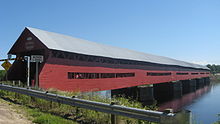
793:
783:
732:
586:
492:
287:
183:
103:
The trail is populated with numerous animals and those travelling along the route will find
77:
647:
642:
297:
249:
73:
51:
806:
755:
717:
632:
576:
463:
233:
85:
901:
568:
237:
747:
707:
408:
264:
218:
176:
62:
722:
697:
637:
614:
507:
120:
28:
883:
870:
268:
128:
16:
139:
467:
154:
95:(PPJ) because it occupies the rail bed of this defunct railway company.
765:
624:
402:
226:
214:
169:
165:
158:
596:
292:
222:
211:
112:
36:
194:
193:
138:
124:
116:
15:
108:
104:
412:
398:
150:
17.26 kilometres (10.7 mi) of pastoral bicycle ride,
259:
The PPJR was incorporated in 1880 and merged with the
845:
792:
764:
746:
623:
595:
567:
549:
506:
483:
444:
354:
352:
274:Its infamous nickname was Push, Pull and Jerk.
263:in 1903. It was the first Canadian railway to
424:
8:
69:. There are 14 rest areas along the route.
431:
417:
409:
338:. Municipality of Mansfield-and-Pontefract
208:Pontiac Pacific Junction Railway Company
323:"Official opening of the PPJ Cyclopark"
314:
175:18 kilometres (11.2 mi) along the
72:The trail originates at Kilometre 0 in
683:Nipissing-North Arm Orienteering Trail
7:
33:Pontiac Regional County Municipality
261:Ottawa Northern and Western Railway
802:Alexander MacKenzie Heritage Trail
521:Greenlink Rotary Park Trail System
182:19.7 kilometres (12.2 mi) on
164:17.7 kilometres (11.0 mi) of
14:
336:"The "Mansfield" Marchand Bridge"
84:, the second longest operational
439:Bike and hiking trails in Canada
373:. CLD du Pontiac. Archived from
153:18 kilometres (11.2 mi) of
93:Pontiac Pacific Junction Railway
458:International Appalachian Trail
812:Galloping Goose Regional Trail
399:Cycloparc PPJ official website
1:
371:"History of the railroad PPJ"
144:Félix-Gabriel-Marchand Bridge
91:The trail is named after the
82:Félix-Gabriel-Marchand Bridge
918:Protected areas of Outaouais
20:Cycloparc PPJ near Shawville
526:Louisbourg Lighthouse Trail
217:that operated in the upper
934:
663:La Cloche Silhouette Trail
198:PPJR Engine No. 4 leaving
817:Juan de Fuca Marine Trail
668:Laura Secord Legacy Trail
485:Newfoundland and Labrador
582:Nepisiguit Mi'gmaq Trail
541:Wilkie Sugar Loaf trail
321:Pontiac Tourism Guide:
908:Transport in Outaouais
827:Vancouver Island Trail
703:Prescott-Russell Trail
688:North Simcoe Railtrail
516:Devils Hill Road Trail
498:Newfoundland T'Railway
203:
146:
21:
913:Rail trails in Quebec
884:45.53417°N 76.31611°W
847:Northwest Territories
738:West Toronto Railpath
536:Uisge Ban Falls Trail
531:Musquodoboit Trailway
232:The railway ran from
210:(PPJR) is a historic
197:
142:
65:and nearby off-trail
19:
855:Canol Heritage Trail
678:Martin Goodman Trail
551:Prince Edward Island
44:Grand Calumet Island
889:45.53417; -76.31611
880: /
713:Spencer Creek Trail
610:P'tit Train du Nord
559:Confederation Trail
99:Wildlife and nature
673:Leaside Spur Trail
658:K&P Rail Trail
474:Trans Canada Trail
452:Great Divide Trail
221:valley in western
204:
147:
22:
863:
862:
822:North Coast Trail
728:The Crack (trail)
303:Tourism in Canada
254:Pembroke, Ontario
225:and northeastern
925:
895:
894:
892:
891:
890:
885:
881:
878:
877:
876:
873:
832:West Coast Trail
794:British Columbia
784:Waskahegan Trail
774:Iron Horse Trail
733:Waterfront Trail
693:Oak Ridges Trail
653:Iron Horse Trail
587:Sentier NB Trail
493:East Coast Trail
433:
426:
419:
410:
386:
385:
383:
382:
367:
361:
356:
347:
346:
344:
343:
332:
326:
319:
288:Adventure travel
184:Allumette Island
135:Trail highlights
78:Allumette Island
933:
932:
928:
927:
926:
924:
923:
922:
898:
897:
888:
886:
882:
879:
874:
871:
869:
867:
866:
864:
859:
841:
788:
760:
742:
648:Don Mills Trail
643:Cataraqui Trail
619:
591:
563:
545:
502:
479:
440:
437:
395:
390:
389:
380:
378:
369:
368:
364:
357:
350:
341:
339:
334:
333:
329:
320:
316:
311:
298:Mountain biking
284:
192:
137:
101:
52:Coulonge Chutes
31:located in the
12:
11:
5:
931:
929:
921:
920:
915:
910:
900:
899:
861:
860:
858:
857:
851:
849:
843:
842:
840:
839:
834:
829:
824:
819:
814:
809:
807:Chilkoot Trail
804:
798:
796:
790:
789:
787:
786:
781:
776:
770:
768:
762:
761:
759:
758:
756:Wascana Trails
752:
750:
744:
743:
741:
740:
735:
730:
725:
720:
718:Spurline Trail
715:
710:
705:
700:
695:
690:
685:
680:
675:
670:
665:
660:
655:
650:
645:
640:
635:
633:Beltline Trail
629:
627:
621:
620:
618:
617:
612:
607:
601:
599:
593:
592:
590:
589:
584:
579:
577:Fundy Footpath
573:
571:
565:
564:
562:
561:
555:
553:
547:
546:
544:
543:
538:
533:
528:
523:
518:
512:
510:
504:
503:
501:
500:
495:
489:
487:
481:
480:
478:
477:
471:
464:Mantario Trail
461:
455:
448:
446:
445:Multi-province
442:
441:
438:
436:
435:
428:
421:
413:
407:
406:
394:
393:External links
391:
388:
387:
362:
348:
327:
325:, May 12, 2008
313:
312:
310:
307:
306:
305:
300:
295:
290:
283:
280:
200:Campbell's Bay
191:
188:
187:
186:
180:
173:
162:
151:
136:
133:
100:
97:
86:covered bridge
13:
10:
9:
6:
4:
3:
2:
930:
919:
916:
914:
911:
909:
906:
905:
903:
896:
893:
856:
853:
852:
850:
848:
844:
838:
835:
833:
830:
828:
825:
823:
820:
818:
815:
813:
810:
808:
805:
803:
800:
799:
797:
795:
791:
785:
782:
780:
779:Skyline Trail
777:
775:
772:
771:
769:
767:
763:
757:
754:
753:
751:
749:
745:
739:
736:
734:
731:
729:
726:
724:
721:
719:
716:
714:
711:
709:
706:
704:
701:
699:
696:
694:
691:
689:
686:
684:
681:
679:
676:
674:
671:
669:
666:
664:
661:
659:
656:
654:
651:
649:
646:
644:
641:
639:
636:
634:
631:
630:
628:
626:
622:
616:
613:
611:
608:
606:
605:Cycloparc PPJ
603:
602:
600:
598:
594:
588:
585:
583:
580:
578:
575:
574:
572:
570:
569:New Brunswick
566:
560:
557:
556:
554:
552:
548:
542:
539:
537:
534:
532:
529:
527:
524:
522:
519:
517:
514:
513:
511:
509:
505:
499:
496:
494:
491:
490:
488:
486:
482:
475:
472:
469:
465:
462:
459:
456:
453:
450:
449:
447:
443:
434:
429:
427:
422:
420:
415:
414:
411:
404:
400:
397:
396:
392:
377:on 2008-04-02
376:
372:
366:
363:
360:
355:
353:
349:
337:
331:
328:
324:
318:
315:
308:
304:
301:
299:
296:
294:
291:
289:
286:
285:
281:
279:
275:
272:
270:
266:
262:
257:
255:
251:
247:
246:Fort Coulonge
243:
239:
235:
230:
228:
224:
220:
216:
213:
209:
202:, circa 1902.
201:
196:
189:
185:
181:
178:
174:
171:
167:
163:
160:
156:
152:
149:
148:
145:
141:
134:
132:
130:
126:
122:
118:
114:
110:
106:
98:
96:
94:
89:
87:
83:
79:
75:
70:
68:
64:
59:
57:
56:Fort-Coulonge
53:
49:
45:
40:
38:
34:
30:
26:
25:Cycloparc PPJ
18:
865:
748:Saskatchewan
708:Rideau Trail
604:
379:. Retrieved
375:the original
365:
340:. Retrieved
330:
317:
276:
273:
258:
231:
219:Ottawa River
207:
205:
177:Ottawa River
102:
90:
76:and ends at
71:
67:Fort William
63:Ottawa River
60:
48:Vinton Plain
41:
24:
23:
887: /
723:The Bentway
698:Pan Am Path
638:Bruce Trail
615:Route Verte
508:Nova Scotia
267:cars using
129:raspberries
125:wild apples
121:blueberries
88:in Canada.
902:Categories
875:76°18′58″W
872:45°32′03″N
460:(NB/QC/NL)
381:2008-04-15
342:2008-06-03
309:References
229:, Canada.
161:sceneries,
39:, Canada.
29:rail trail
269:acetylene
242:Shawville
837:Wildside
282:See also
236:through
212:Canadian
155:wetlands
766:Alberta
625:Ontario
454:(AB/BC)
403:English
250:Waltham
227:Ontario
215:railway
190:History
179:shores,
170:forests
166:meadows
159:valleys
597:Quebec
293:Hiking
248:, and
234:Aylmer
223:Quebec
113:beaver
46:, the
37:Quebec
476:(All)
265:light
238:Quyon
117:moose
74:Wyman
54:near
27:is a
470:/ON)
206:The
168:and
157:and
127:and
115:and
109:bear
105:deer
50:and
252:to
35:in
904::
468:MB
351:^
271:.
256:.
244:,
240:,
131:.
123:,
111:,
107:,
466:(
432:e
425:t
418:v
405:)
401:(
384:.
345:.
172:,
Text is available under the Creative Commons Attribution-ShareAlike License. Additional terms may apply.