70:
254:
54:
230:
217:
1145:
77:
246:
238:
625:
invasion Inca roads were constructed, incorporating preexisting roads. Twenty-eight archeological sites have been identified in the park and its vicinity that indicate inhabitation during the pre-Incan and Incan periods. During the
Colonial time the vicinity of the area was used for livestock. With
626:
the creation of the park the area has become popular for hiking, climbing, camping, fishing, and birdwatching. Control points are located at the road entries to the park. The park has a refuge hut and can be reached from Cuenca and
Guayaquil. A road from
367:
The climate shows an average temperature of 13.2 °C and an average annual precipitation of 1,072 mm. Clouds typically drift up from the
Pacific coast and from the Paute river basin (near Cuenca) and bring humidity.
761:
381:
Humidity and high altitude with low atmospheric pressure create an ecosystem that accumulates organic material in the soil that is able to retain water. The high grassland ecosystem (
328:
of Cajas. Luspa is the largest of these lake and extends over 78 hectares with a maximum depth of 68 m at a perimeter of 5,161 m. Like the other lakes it is of glacial origin, and
854:
782:
1194:
316:
The highest point is the 4,450 m high Cerro
Arquitectos (Architects Hill), and the elevation of roads reaches higher than 4,310 meters (13,550 feet). About 270
122:
1204:
1179:
748:
Assessors: León-Yánez, S.; Pitman, N. / Evaluators: Valencia, R.; Pitman, N.; León-Yánez, S.; Jørgensen, P.M. (Ecuador Plants Red List
Authority) (2004).
69:
847:
1199:
938:
308:
word "cassa" meaning "gateway to the snowy mountains". or "caxa" (Quichua:cold). It has also been linked to the
Spanish word "cajas" (boxes).
797:
1189:
989:
979:
840:
1174:
361:
912:
863:
1184:
1004:
969:
1020:
39:
1098:
1072:
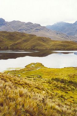
1093:
1051:
827:
414:, is predicted to live, as it has also been found in another nearby national park of similar ecological characteristics.
1077:
999:
964:
974:
364:
at the pass "Tres Cruces" (4,255 m). This section is the most western part of the continental divide of South
America.
984:
959:
651:
1130:
1041:
887:
1169:
1046:
1036:
994:
892:
469:
1114:
902:
897:
391:
1067:
922:
917:
631:
100:
798:"Distribution, ecology and conservation of an endangered Andean hummingbird: the Violet-throated Metaltail"
882:
668:
618:
446:
352:
river also links to the Amazon. As the park straddles the continental divide, its western drainage, the
552:
627:
907:
288:. The area of 285.44 km (28,544 ha) between 3100m and 4450m above sea level is characterized by
332:
shaped the landscape of Cajas leaving U-shaped valleys and ravines. Cajas provides about 60% of the
647:
542:
221:
808:
484:
Overall, forty-four mammalian species have been identified in the park. Species include types of
404:) forest is found. It is in forests such as these that a second protected population of the rare
776:
693:
643:
587:
434:
253:
175:
53:
305:
281:
269:
337:
110:
1149:
621:, a control point for the trade between the highlands and the coastal areas. After the
459:
406:
357:
341:
333:
229:
216:
1163:
442:
293:
43:
547:
478:
450:
418:
345:
17:
796:
Boris A. Tinoco; Pedro X. Astudillo; Steven C. Latta; Catherine H. Graham (2008).
433:
The Cajas
National Park is home to a large variety of animals, some of which are
943:
749:
593:
581:
575:
454:
353:
349:
336:
for the Cuenca area. Two of the four rivers of Cuenca originate from Cajas, the
245:
613:
period. This includes three interregional roads connecting
Guapondelig (later
438:
411:
329:
832:
137:
124:
614:
560:
517:
400:
610:
382:
325:
289:
597:. The high variety of amphibians suggests the presence of a diversity of
569:
537:
386:
292:
vegetation on a jagged landscape of hills and valleys. It was declared a
237:
489:
485:
277:
96:
655:
598:
564:
533:
529:
505:
497:
422:
321:
762:
International Union for
Conservation of Nature and Natural Resources
688:
724:"Parque National Cajas", map and brochure from Etapa, Cuenca, 2009
525:
509:
501:
464:
285:
252:
244:
236:
215:
421:
and perennial high mountain forest are present, primarily in the
622:
521:
474:
317:
836:
513:
493:
634:
touches on the southern border of the park providing access.
609:
The area shows evidence of human activities already from the
360:
link to the Pacific ocean. The modern road crosses the
736:
445:, of which only 80 remain throughout all Ecuador; the
385:) contains plants suitably adapted to it, 19 of them
1123:
1107:
1086:
1060:
1029:
1013:
952:
931:
870:
473:) is endemic to Cajas and surrounding valleys. The
198:
190:
182:
173:
169:
161:
153:
116:
106:
92:
32:
758:IUCN Red List of Threatened Species. Vers. 2009.1
398:Above 3,300 meters the "queñua" or "paper tree" (
76:
848:
601:, as they are a chief amphibian food source.
389:to Cajas. The dominant plant is straw grass (
8:
781:: CS1 maint: multiple names: authors list (
617:, today Cuenca) with the lowlands including
567:of Cajas. This includes those of the genera
280:. It is located about 30 km west from
855:
841:
833:
644:Ramsar Wetland of International Importance
296:on November 5, 1996 by resolution N° 057.
29:
276:) is a national park in the highlands of
467:flowers. The violet-throated metaltail (
228:
732:
730:
720:
718:
716:
714:
712:
680:
344:rivers which eventually drain into the
774:
1195:Tourist attractions in Azuay Province
477:consists of 157 bird species, making
457:of the world, the giant hummingbird (
304:The name "Cajas" is derived from the
197:
189:
181:
172:
157:285.4 km (110.2 sq mi)
7:
417:In the lower parts of the park, the
165:November 5, 1996 (Resolution N° 057)
91:
1205:Northwestern Andean montane forests
1180:Protected areas established in 1996
481:an alluring activity for visitors.
441:. Among the most prominent are the
650:. Currently it is a candidate for
25:
284:, the capital of the province of
1143:
225:growing near a lake in the park.
75:
68:
52:
805:Bird Conservation International
646:. It is also categorized as an
160:
105:
58:A lagoon in Cajas National Park
1200:1996 establishments in Ecuador
559:At least seventeen species of
1:
546:) that belongs to the group
540:are the Cajas water mouse (
425:near the brooks and rivers.
1190:Geography of Azuay Province
1087:National Recreational Parks
652:World Natural Heritage Site
257:Scenic view within the park
1221:
864:Protected areas of Ecuador
550:and Tate's shrew opossum (
449:, a large black and white
1175:National parks of Ecuador
1139:
828:Etapa site about the park
696:Sites Information Service
210:
206:
63:
51:
37:
27:Protected area in Ecuador
392:Calamagrostis intermedia
274:Parque Nacional El Cajas
1185:Ramsar sites in Ecuador
689:"Parque Nacional Cajas"
463:), which lives only on
1073:Muisne River Mangroves
737:Cajas Park information
638:International listings
273:
262:El Cajas National Park
258:
250:
242:
234:
226:
33:El Cajas National Park
1014:Geobotanical Reserves
669:Pristimantis erythros
642:Cajas is listed as a
470:Metalura gorjivioleta
443:South American condor
312:Geography and climate
256:
248:
240:
232:
219:
186:Parque Nacional Cajas
138:2.84611°S 79.22028°W
953:Ecological Reserves
932:Biological Reserves
913:Sumaco Napo-Galeras
648:Important Bird Area
543:Chibchanomys orcesi
324:are present in the
266:Cajas National Park
233:A lake in El Cajas.
222:Chuquiraga jussieui
143:-2.84611; -79.22028
134: /
84:Location in Ecuador
18:Cajas National Park
1150:Ecuador portal
1078:Santa Clara Island
453:, and the largest
362:continental divide
259:
251:
243:
235:
227:
199:Reference no.
1157:
1156:
1030:Wildlife Reserves
990:Cotacachi Cayapas
980:Churute Mangroves
588:Eleutherodactylus
553:Caenolestes tatei
496:. Also there are
214:
213:
107:Nearest city
16:(Redirected from
1212:
1170:IUCN Category II
1148:
1147:
1146:
1108:Binational Parks
1061:Wildlife Refuges
857:
850:
843:
834:
816:
815:
813:
807:. Archived from
802:
793:
787:
786:
780:
772:
770:
768:
745:
739:
734:
725:
722:
707:
706:
704:
702:
685:
563:live around the
410:, in the family
149:
148:
146:
145:
144:
139:
135:
132:
131:
130:
127:
79:
78:
72:
56:
30:
21:
1220:
1219:
1215:
1214:
1213:
1211:
1210:
1209:
1160:
1159:
1158:
1153:
1144:
1142:
1135:
1124:Marine Reserves
1119:
1103:
1082:
1056:
1025:
1009:
948:
927:
866:
861:
824:
819:
811:
800:
795:
794:
790:
773:
766:
764:
747:
746:
742:
735:
728:
723:
710:
700:
698:
687:
686:
682:
678:
664:
640:
607:
431:
379:
374:
314:
302:
178:
142:
140:
136:
133:
128:
125:
123:
121:
120:
99:
88:
87:
86:
85:
82:
81:
80:
59:
47:
28:
23:
22:
15:
12:
11:
5:
1218:
1216:
1208:
1207:
1202:
1197:
1192:
1187:
1182:
1177:
1172:
1162:
1161:
1155:
1154:
1140:
1137:
1136:
1134:
1133:
1127:
1125:
1121:
1120:
1118:
1117:
1111:
1109:
1105:
1104:
1102:
1101:
1096:
1090:
1088:
1084:
1083:
1081:
1080:
1075:
1070:
1064:
1062:
1058:
1057:
1055:
1054:
1049:
1044:
1042:Corazón Island
1039:
1033:
1031:
1027:
1026:
1024:
1023:
1017:
1015:
1011:
1010:
1008:
1007:
1002:
997:
992:
987:
982:
977:
975:Cayapas Mataje
972:
967:
962:
956:
954:
950:
949:
947:
946:
941:
935:
933:
929:
928:
926:
925:
920:
915:
910:
905:
900:
895:
890:
885:
880:
874:
872:
871:National Parks
868:
867:
862:
860:
859:
852:
845:
837:
831:
830:
823:
822:External links
820:
818:
817:
814:on 2011-09-28.
788:
752:Fuchsia campii
740:
726:
708:
679:
677:
674:
673:
672:
663:
660:
639:
636:
606:
603:
460:Patagona gigas
430:
427:
407:Fuchsia campii
378:
375:
373:
370:
334:drinking water
313:
310:
301:
298:
241:Park entrance.
212:
211:
208:
207:
204:
203:
200:
196:
195:
194:14 August 2002
192:
188:
187:
184:
180:
179:
176:Ramsar Wetland
174:
171:
170:
167:
166:
163:
159:
158:
155:
151:
150:
118:
114:
113:
108:
104:
103:
101:Azuay Province
94:
90:
89:
83:
74:
73:
67:
66:
65:
64:
61:
60:
57:
49:
48:
38:
35:
34:
26:
24:
14:
13:
10:
9:
6:
4:
3:
2:
1217:
1206:
1203:
1201:
1198:
1196:
1193:
1191:
1188:
1186:
1183:
1181:
1178:
1176:
1173:
1171:
1168:
1167:
1165:
1152:
1151:
1138:
1132:
1129:
1128:
1126:
1122:
1116:
1113:
1112:
1110:
1106:
1100:
1097:
1095:
1092:
1091:
1089:
1085:
1079:
1076:
1074:
1071:
1069:
1066:
1065:
1063:
1059:
1053:
1050:
1048:
1045:
1043:
1040:
1038:
1035:
1034:
1032:
1028:
1022:
1019:
1018:
1016:
1012:
1006:
1005:Mache Chindul
1003:
1001:
998:
996:
993:
991:
988:
986:
985:Cofán Bermejo
983:
981:
978:
976:
973:
971:
968:
966:
963:
961:
958:
957:
955:
951:
945:
942:
940:
937:
936:
934:
930:
924:
921:
919:
916:
914:
911:
909:
906:
904:
901:
899:
896:
894:
891:
889:
886:
884:
881:
879:
876:
875:
873:
869:
865:
858:
853:
851:
846:
844:
839:
838:
835:
829:
826:
825:
821:
810:
806:
799:
792:
789:
784:
778:
763:
759:
755:
754:in IUCN 2009"
753:
744:
741:
738:
733:
731:
727:
721:
719:
717:
715:
713:
709:
697:
695:
690:
684:
681:
675:
671:
670:
666:
665:
661:
659:
657:
653:
649:
645:
637:
635:
633:
629:
624:
620:
616:
612:
604:
602:
600:
596:
595:
590:
589:
584:
583:
578:
577:
572:
571:
566:
562:
557:
555:
554:
549:
545:
544:
539:
535:
531:
527:
523:
519:
515:
511:
507:
503:
499:
495:
491:
487:
482:
480:
476:
472:
471:
466:
462:
461:
456:
452:
448:
444:
440:
436:
428:
426:
424:
420:
415:
413:
409:
408:
403:
402:
396:
394:
393:
388:
384:
376:
371:
369:
365:
363:
359:
355:
351:
347:
343:
339:
335:
331:
327:
323:
319:
311:
309:
307:
299:
297:
295:
294:National Park
291:
287:
283:
279:
275:
271:
267:
263:
255:
247:
239:
231:
224:
223:
218:
209:
205:
201:
193:
185:
183:Official name
177:
168:
164:
156:
152:
147:
119:
115:
112:
109:
102:
98:
95:
71:
62:
55:
50:
45:
44:national park
41:
40:IUCN category
36:
31:
19:
1141:
970:Cayambe Coca
877:
809:the original
804:
791:
765:. Retrieved
757:
751:
743:
699:. Retrieved
692:
683:
667:
641:
608:
592:
586:
580:
574:
568:
558:
551:
548:Ichthyomyini
541:
483:
479:birdwatching
468:
458:
432:
419:cloud forest
416:
405:
399:
397:
390:
380:
366:
346:Amazon River
315:
303:
265:
261:
260:
220:
1099:Parque Lago
944:Maquipucuna
893:Llanganates
767:October 26,
632:San Joaquin
594:Colostethus
582:Gastrotheca
576:Telmatobius
455:hummingbird
249:Low clouds.
162:Established
141: /
117:Coordinates
1164:Categories
1094:El Boliche
1037:Chimborazo
939:Limoncocha
903:Podocarpus
898:Machalilla
676:References
605:Archeology
561:amphibians
532:and other
518:porcupines
447:curiquinga
439:endangered
437:or highly
412:Onagraceae
330:glaciation
191:Designated
129:79°13′13″W
126:02°50′46″S
1131:Galápagos
1115:El Condor
1052:El Salado
1021:Pululahua
1000:Illinizas
965:Arenillas
888:Galápagos
619:Paredones
615:Tomebamba
401:Polylepis
338:Tomebamba
1068:Pasochoa
1047:Cuyabeno
995:El Ángel
960:Antisana
883:Cotopaxi
777:cite web
701:25 April
662:See also
570:Atelopus
486:opossums
475:avifauna
342:Yanuncay
93:Location
628:Chaucha
599:insects
565:lagoons
538:Endemic
534:rodents
530:rabbits
506:weasels
435:endemic
423:ravines
387:endemic
372:Ecology
322:lagoons
306:Quichua
278:Ecuador
270:Spanish
97:Ecuador
923:Yasuní
918:Yacurí
908:Sangay
694:Ramsar
656:UNESCO
611:Cañari
591:, and
526:shrews
510:skunks
502:coatis
492:, and
451:raptor
383:páramo
348:. The
326:páramo
290:páramo
282:Cuenca
111:Cuenca
878:Cajas
812:(PDF)
801:(PDF)
623:Incan
522:pacas
514:foxes
498:pumas
465:agave
429:Fauna
377:Flora
358:Cañar
354:Balao
350:Paute
318:lakes
286:Azuay
783:link
769:2009
703:2018
494:bats
490:cats
356:and
340:and
320:and
300:Name
202:1203
154:Area
42:II (
654:by
630:to
556:).
395:).
264:or
1166::
803:.
779:}}
775:{{
760:.
756:.
729:^
711:^
691:.
658:.
585:,
579:,
573:,
536:.
528:,
524:,
520:,
516:,
512:,
508:,
504:,
500:,
488:,
272::
856:e
849:t
842:v
785:)
771:.
750:"
705:.
268:(
46:)
20:)
Text is available under the Creative Commons Attribution-ShareAlike License. Additional terms may apply.