47:
553:
109:
33:
588:
128:
273:
258:
636:
88:
438:, based on the alignment that existed at the time, and do not necessarily reflect current mileage. R reflects a realignment in the route since then, M indicates a second realignment, L refers to an overlap due to a correction or change, and T indicates postmiles classified as temporary (
414:, SR 34 was defined with this routing, ending at SR 118 on the eastern side. In 1965, the highway from Port Hueneme to SR 1 was removed from the state highway system. The part of the highway in Oxnard was authorized by the state legislature to be turned over to the city of Oxnard in 2008.
359:. After continuing east on Pleasant Valley Road a short distance, it turns north onto Lewis Road until the intersection with Las Posas Road at the north city limit of Camarillo where Route 34 continues straight ahead as Somis Road. It ends at
852:"An act to add Section 253 and Article 3 (commencing with Section 300) to Chapter 2 of Division 1 of, and to repeal Section 253 and Article 3 (commencing with Section 300) of Chapter 2 of Division 1 of, the..."
874:"An act to amend Sections 253, 307, 317, 322, 334, 342, 347, 349, 361, 363, 372, 373, 374, 379, 384, 390, 407, 408, 443, 455, 470, 486, 514, 517, 548, and 550 of, to add Sections 556, 557, 558, 560..."
807:"An act to amend sections 2, 3 and 5 and to add two sections to be numbered 6 and 7 to an act entitled 'An act to provide for the acquisition of rights of way for and the construction, maintenance..."
1027:
698:
410:
In 1933, a road from
Hueneme to near Somis, going through Oxnard and Camarillo, was added to the state highway system. This road was numbered as Route 153 in 1935. In the
968:
422:
According to the 2017 Caltrans
District 7 Transportation Concept Report for State Route 34, State Route 34 is on the list of routes recommended for relinquishment.
226:
221:
1022:
539:
516:
435:
411:
20:
231:
201:
665:
337:
241:
216:
341:
1017:
236:
211:
383:
779:
206:
931:
895:
873:
851:
828:
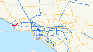
806:
725:
445:). Segments that remain unconstructed or have been relinquished to local control may be omitted. The entire route is in
345:
556:
193:
112:
1032:
375:
was deleted. Nevertheless, Route 34 mileposts add on these additional 4 miles (6.4 km) along the signed route.
591:
446:
360:
321:
309:
174:
131:
276:
261:
599:
490:
372:
368:
313:
91:
344:, a network of highways that are considered essential to the country's economy, defense, and mobility by the
640:
568:
669:
535:
512:
379:
526:
508:
356:
116:
595:
564:
441:
431:
399:
470:
352:
317:
95:
355:. It continues east then northeast on Fifth Street until it intersects Pleasant Valley Road in
959:
578:
394:
364:
325:
135:
753:
46:
674:
560:
388:
1011:
297:
154:
1002:
992:
780:"California Street and Highway Codes Division 1 Chapter 2 Article 3 Section 334"
305:
301:
164:
997:
351:
It starts on the west at the intersection of Rice Avenue and Fifth Street in
32:
63:
967:
733:(Map). Scale not given. Washington, DC: Federal Highway Administration
752:
Natzke, Stefan; Neathery, Mike & Adderly, Kevin (June 20, 2012).
668:. Sacramento: California Department of Transportation. Archived from
340:, and portions of the route in Oxnard and Camarillo are part of the
982:
977:
620:
1.000 mi = 1.609 km; 1.000 km = 0.621 mi
19:"CA 34" redirects here. For the congressional district, see
987:
442:
California postmile § Official postmile definitions
402:
passenger trains, for almost its entire current length.
955:
950:
1003:
2003 Caltrans
District 7 Master System Plan Status Map
934:. Sacramento: California Department of Transportation.
705:. Sacramento: California Office of Legislative Counsel
930:
California
Department of Transportation (July 2007).
184:
170:
160:
150:
145:
122:
101:
82:
77:
69:
56:
28:
481:Continuation beyond Rice Avenue; former SR 34 west
1028:Buildings and structures in Camarillo, California
724:Federal Highway Administration (March 25, 2015).
978:Caltrans: State Route 34 highway conditions
760:. Washington, DC: Federal Highway Administration
371:, but in 1965, the portion from Port Hueneme to
969:Template:Attached KML/California State Route 34
816:. State of California. Ch. 767 p. 2034–2042.
534:Pleasant Valley east, Lewis Road south –
8:
917:Transportation Concept Report State Route 34
988:California Highway Patrol Traffic Incidents
659:
657:
655:
451:
250:
993:California @ AARoads.com - State Route 34
972:
861:. State of California. Ch. 385 p. 1182.
664:California Department of Transportation.
911:
909:
338:California Freeway and Expressway System
21:California's 34th congressional district
651:
496:West end of SR 34 and state maintenance
434:were measured on the road as it was in
754:"What is the National Highway System?"
699:"Article 2 of Chapter 2 of Division 1"
25:
829:"An act...relating to State highways"
611:
608:
585:
582:
550:
547:
533:
530:
506:
503:
488:
485:
477:
474:
430:Except where prefixed with a letter,
7:
703:California Streets and Highways Code
73:13.368 mi (21.514 km)
1023:Roads in Ventura County, California
727:National Highway System: Oxnard, CA
932:"Log of Bridges on State Highways"
784:California Legislative Information
14:
919:. Caltrans District 7. June 2017.
440:for a full list of prefixes, see
367:. This route originally began in
883:. State of California. Ch. 1372.
634:
586:
551:
271:
256:
126:
107:
86:
45:
31:
983:Caltrans Traffic Conditions Map
902:. State of California. Ch. 717.
898:. Session of the Legislature.
839:. State of California. Ch. 274.
412:1964 state highway renumbering
346:Federal Highway Administration
1:
896:" Session of the Legislature"
1018:State highways in California
879:Session of the Legislature.
857:Session of the Legislature.
835:Session of the Legislature.
812:Session of the Legislature.
594:(Los Angeles Avenue) –
573:Interchange; US 101 exit 53B
194:State highways in California
894:California State Assembly.
872:California State Assembly.
850:California State Assembly.
827:California State Assembly.
805:California State Assembly.
641:California Roads portal
439:
1049:
998:California Highways: SR 34
615:Continuation beyond SR 118
521:Connects to SR 1 or US 101
18:
619:
614:
603:
577:
572:
543:
525:
520:
500:
495:
480:
469:
464:
461:
457:
454:
249:
189:
180:
141:
61:
44:
666:"State Truck Route List"
378:The route parallels the
51:SR 34 highlighted in red
758:National Highway System
342:National Highway System
900:Statutes of California
881:Statutes of California
859:Statutes of California
837:Statutes of California
814:Statutes of California
507:Las Posas Road –
380:Union Pacific Railroad
336:SR 34 is part of the
16:Highway in California
973:KML is from Wikidata
679:on September 5, 2015
540:CSU Channel Islands
517:CSU Channel Islands
426:Major intersections
400:Ventura County Line
103:Major intersections
1033:Oxnard, California
312:from Rice Avenue (
308:. It runs through
625:
624:
604:East end of SR 34
395:Pacific Surfliner
332:Route description
287:
286:
283:
282:
57:Route information
1040:
963:
936:
935:
927:
921:
920:
913:
904:
903:
891:
885:
884:
878:
869:
863:
862:
856:
847:
841:
840:
834:
824:
818:
817:
811:
802:
796:
795:
793:
791:
786:. 1 January 2015
776:
770:
769:
767:
765:
749:
743:
742:
740:
738:
732:
721:
715:
714:
712:
710:
695:
689:
688:
686:
684:
678:
661:
639:
638:
637:
590:
589:
555:
554:
452:
444:
386:, which carries
279:
275:
274:
264:
260:
259:
251:
130:
129:
111:
110:
104:
90:
89:
49:
35:
26:
1048:
1047:
1043:
1042:
1041:
1039:
1038:
1037:
1008:
1007:
974:
971:
966:
965:
964:
948:
944:
939:
929:
928:
924:
915:
914:
907:
893:
892:
888:
876:
871:
870:
866:
854:
849:
848:
844:
832:
826:
825:
821:
809:
804:
803:
799:
789:
787:
778:
777:
773:
763:
761:
751:
750:
746:
736:
734:
730:
723:
722:
718:
708:
706:
697:
696:
692:
682:
680:
672:
663:
662:
653:
649:
635:
633:
630:
621:
587:
561:Ventura Freeway
552:
459:
428:
420:
408:
389:Coast Starlight
334:
322:State Route 118
272:
270:
257:
255:
127:
108:
102:
87:
78:Major junctions
52:
40:
39:
36:
24:
17:
12:
11:
5:
1046:
1044:
1036:
1035:
1030:
1025:
1020:
1010:
1009:
1006:
1005:
1000:
995:
990:
985:
980:
947:
946:
945:
943:
942:External links
940:
938:
937:
922:
905:
886:
864:
842:
819:
797:
771:
744:
716:
690:
650:
648:
645:
644:
643:
629:
626:
623:
622:
617:
616:
613:
610:
606:
605:
602:
584:
581:
575:
574:
571:
549:
545:
544:
542:
532:
529:
523:
522:
519:
505:
502:
498:
497:
494:
487:
483:
482:
479:
476:
473:
467:
466:
463:
460:
456:
447:Ventura County
427:
424:
419:
416:
407:
404:
333:
330:
310:Ventura County
290:State Route 34
285:
284:
281:
280:
267:
265:
247:
246:
245:
244:
239:
234:
229:
227:Pre‑1964
224:
219:
214:
209:
204:
198:
197:
187:
186:
185:Highway system
182:
181:
178:
177:
172:
168:
167:
162:
158:
157:
152:
148:
147:
143:
142:
139:
138:
124:
120:
119:
105:
99:
98:
84:
80:
79:
75:
74:
71:
67:
66:
62:Maintained by
59:
58:
54:
53:
50:
42:
41:
38:State Route 34
37:
30:
29:
15:
13:
10:
9:
6:
4:
3:
2:
1045:
1034:
1031:
1029:
1026:
1024:
1021:
1019:
1016:
1015:
1013:
1004:
1001:
999:
996:
994:
991:
989:
986:
984:
981:
979:
976:
975:
970:
961:
957:
953:
952:
941:
933:
926:
923:
918:
912:
910:
906:
901:
897:
890:
887:
882:
875:
868:
865:
860:
853:
846:
843:
838:
830:
823:
820:
815:
808:
801:
798:
785:
781:
775:
772:
759:
755:
748:
745:
729:
728:
720:
717:
704:
700:
694:
691:
676:
671:
667:
660:
658:
656:
652:
646:
642:
632:
631:
627:
618:
607:
601:
597:
593:
580:
576:
570:
566:
562:
558:
546:
541:
537:
528:
524:
518:
514:
510:
499:
492:
489:Rice Avenue (
484:
472:
468:
453:
450:
448:
443:
437:
433:
425:
423:
417:
415:
413:
405:
403:
401:
397:
396:
391:
390:
385:
381:
376:
374:
370:
366:
362:
358:
354:
349:
347:
343:
339:
331:
329:
327:
323:
319:
315:
314:State Route 1
311:
307:
303:
299:
298:state highway
295:
291:
278:
268:
266:
263:
253:
252:
248:
243:
240:
238:
235:
233:
232:Unconstructed
230:
228:
225:
223:
220:
218:
215:
213:
210:
208:
205:
203:
200:
199:
196:
195:
191:
190:
188:
183:
179:
176:
173:
169:
166:
163:
159:
156:
155:United States
153:
149:
144:
140:
137:
133:
125:
123:East end
121:
118:
114:
106:
100:
97:
93:
85:
83:West end
81:
76:
72:
68:
65:
60:
55:
48:
43:
34:
27:
22:
949:
925:
916:
899:
889:
880:
867:
858:
845:
836:
833:Fifty-first
822:
813:
800:
788:. Retrieved
783:
774:
762:. Retrieved
757:
747:
735:. Retrieved
726:
719:
707:. Retrieved
702:
693:
681:. Retrieved
670:the original
600:San Fernando
478:Fifth Street
462:Destinations
429:
421:
409:
393:
387:
377:
369:Port Hueneme
350:
335:
293:
289:
288:
192:
737:October 16,
709:February 6,
612:Donlon Road
592:SR 118
569:Los Angeles
557:US 101
132:SR 118
113:US 101
1012:Categories
647:References
536:Point Mugu
513:Point Mugu
384:Coast Line
306:California
302:U.S. state
277:SR 35
262:SR 33
202:Interstate
165:California
810:Fiftieth
563:) –
527:Camarillo
509:Camarillo
491:SR 1
432:postmiles
361:Route 118
357:Camarillo
117:Camarillo
92:SR 1
951:KML file
683:June 30,
675:XLS file
628:See also
458:Postmile
455:Location
242:Freeways
171:Counties
146:Location
64:Caltrans
790:7 March
764:July 1,
596:Ventura
565:Ventura
501:
406:History
373:Route 1
300:in the
296:) is a
237:Deleted
222:History
175:Ventura
151:Country
471:Oxnard
418:Future
353:Oxnard
318:Oxnard
217:Scenic
96:Oxnard
70:Length
877:1965
855:1963
731:(PDF)
609:17.66
583:17.66
579:Somis
548:13.60
531:12.78
504:10.43
465:Notes
365:Somis
363:near
326:Somis
316:) in
294:SR 34
212:State
161:State
136:Somis
960:help
956:edit
792:2018
766:2012
739:2017
711:2019
685:2015
486:6.27
475:6.27
436:1964
398:and
382:'s
324:in
320:to
304:of
134:at
115:in
94:in
1014::
958:•
908:^
831:.
782:.
756:.
701:.
654:^
598:,
567:,
538:,
515:,
511:,
449:.
392:,
348:.
328:.
269:→
254:←
207:US
962:)
954:(
794:.
768:.
741:.
713:.
687:.
677:)
673:(
559:(
493:)
292:(
23:.
Text is available under the Creative Commons Attribution-ShareAlike License. Additional terms may apply.