684:
138:
131:
36:
507:
Radio San
Gabriel, "Instituto Radiofonico de Promoción Aymara" (IRPA) 1993, Republicado por Instituto de las Lenguas y Literaturas Andinas-Amazónicas (ILLLA-A) 2011, Transcripción del Vocabulario de la Lengua Aymara, P.
721:
87:
750:
740:
714:
346:
755:
80:
250:, with an elevation of 6,110 metres (20,046 ft). Another peak in the massif is called Ccallangate. It lies in the
707:
130:
745:
243:
483:
568:
341:
283:
683:
542:
331:
295:
68:
58:
336:
315:
255:
669:
637:
216:
185:
523:
664:
613:
366:
509:
259:
236:
691:
409:
525:
Diccionario Bilingüe: Iskay simipi yuyayk’anch: Quechua – Castellano / Castellano – Quechua
274:
Callangate was first climbed by
Germans Günther Hauser and Bernhard Kuhn on 30 July 1957.
232:
174:
734:
263:
251:
197:
163:
307:
498:
escale.minedu.gob.pe - UGEL maps of the
Quispicanchi Province 1 (Cusco Region)
319:
102:
89:
311:
73:
17:
438:
16:
For the mountain on the border of the regions of Cusco and Puno, Peru, see
569:"Base de datos Perú - Shapefile - *.shp - MINAM - IGN - Límites Políticos"
287:
35:
299:
291:
48:
589:
220:
181:
690:
This Peru mountain, mountain range, or peak related article is a
546:
302:. Callangate is considered a Mountain Subrange according to the
224:
167:
388:
386:
695:
202:
30 July 1957, Günther Hauser, Bernhard Kuhn (Germany)
590:"Shuttle Radar Topographic Mission - Filled Data V2"
196:
191:
173:
159:
118:
79:
67:
57:
47:
42:
28:
512:1612 (Spanish-Aymara-Aymara-Spanish dictionary)
286:: SRTM 6104 metres. The height of the nearest
262:. Collpa Ananta is the second-highest peak in
715:
470:. IGN (Instituto Geográfico Nacional - Perú).
8:
531:. La Paz, Bolivia: futatraw.ourproject.org.
722:
708:
25:
266:, and ranks as the 24th highest in Peru.
614:"Callangate / Collpa Ananta / Cayangate"
367:"Callangate / Collpa Ananta / Cayangate"
486:Map of the area showing "Collpa Ananta"
358:
665:Elevation information about Callangate
608:
606:
7:
680:
678:
543:"Callangate - Cusco, Peru • peakery"
494:
492:
479:
477:
462:
460:
458:
433:
431:
694:. You can help Knowledge (XXG) by
137:
14:
588:NASA, Jet Propulsion Laboratory.
393:"AAJ (American Alpine Journal)".
306:and its dominance is 22.96%. Its
682:
136:
129:
34:
468:Peru 1:100 000, Ocongate (28-t)
670:Weather Forecast at Callangate
522:Teofilo Laime Ajacopa (2007).
347:List of mountains in the Andes
1:
545:. Peakery.com. Archived from
439:"Callangate - Peakbagger.com"
395:AAJ (American Alpine Journal)
53:6,110 m (20,050 ft)
751:Six-thousanders of the Andes
215:is a mountain massif in the
63:1,403 m (4,603 ft)
772:
677:
282:Other data from available
15:
741:Mountains of Cusco Region
342:List of mountains in Peru
123:
33:
284:digital elevation models
227:. Its highest point is
567:PERU, Autor: GEO GPS.
296:topographic prominence
219:mountain range of the
316:Topographic isolation
256:Quispicanchi Province
103:13.73139°S 71.16000°W
638:"Dominance - Page 2"
108:-13.73139; -71.16000
756:Peru mountain stubs
99: /
246:"), also known as
43:Highest point
746:Mountains of Peru
703:
702:
618:Andes Specialists
510:Ludovico Bertonio
371:Andes Specialists
260:Ocongate District
206:
205:
763:
724:
717:
710:
686:
679:
652:
651:
649:
648:
634:
628:
627:
625:
624:
610:
601:
600:
598:
596:
585:
579:
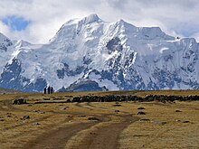
578:
576:
575:
564:
558:
557:
555:
554:
539:
533:
532:
530:
519:
513:
505:
499:
496:
487:
481:
472:
471:
464:
453:
452:
450:
449:
435:
426:
425:
423:
421:
405:
399:
398:
397:: 109–110. 1958.
390:
381:
380:
378:
377:
363:
304:Dominance System
177:
140:
139:
133:
114:
113:
111:
110:
109:
104:
100:
97:
96:
95:
92:
38:
26:
23:Mountain in Peru
771:
770:
766:
765:
764:
762:
761:
760:
731:
730:
729:
728:
675:
661:
656:
655:
646:
644:
642:www.8000ers.com
636:
635:
631:
622:
620:
612:
611:
604:
594:
592:
587:
586:
582:
573:
571:
566:
565:
561:
552:
550:
541:
540:
536:
528:
521:
520:
516:
506:
502:
497:
490:
482:
475:
466:
465:
456:
447:
445:
437:
436:
429:
419:
417:
407:
406:
402:
392:
391:
384:
375:
373:
365:
364:
360:
355:
328:
294:, leading to a
280:
272:
231:(possibly from
175:
155:
154:
153:
152:
151:
148:
147:
146:
145:
141:
107:
105:
101:
98:
93:
90:
88:
86:
85:
24:
21:
12:
11:
5:
769:
767:
759:
758:
753:
748:
743:
733:
732:
727:
726:
719:
712:
704:
701:
700:
687:
673:
672:
667:
660:
659:External links
657:
654:
653:
629:
602:
580:
559:
534:
514:
500:
488:
484:lib.utexas.edu
473:
454:
443:peakbagger.com
427:
416:. Andes.org.uk
400:
382:
357:
356:
354:
351:
350:
349:
344:
339:
334:
327:
324:
279:
276:
271:
268:
204:
203:
200:
194:
193:
189:
188:
179:
171:
170:
161:
157:
156:
149:
143:
142:
135:
134:
128:
127:
126:
125:
124:
121:
120:
116:
115:
83:
77:
76:
71:
65:
64:
61:
55:
54:
51:
45:
44:
40:
39:
31:
30:
22:
13:
10:
9:
6:
4:
3:
2:
768:
757:
754:
752:
749:
747:
744:
742:
739:
738:
736:
725:
720:
718:
713:
711:
706:
705:
699:
697:
693:
688:
685:
681:
676:
671:
668:
666:
663:
662:
658:
643:
639:
633:
630:
619:
615:
609:
607:
603:
591:
584:
581:
570:
563:
560:
549:on 2013-10-14
548:
544:
538:
535:
527:
526:
518:
515:
511:
504:
501:
495:
493:
489:
485:
480:
478:
474:
469:
463:
461:
459:
455:
444:
440:
434:
432:
428:
415:
414:Andes Website
411:
408:John Biggar.
404:
401:
396:
389:
387:
383:
372:
368:
362:
359:
352:
348:
345:
343:
340:
338:
335:
333:
330:
329:
325:
323:
321:
317:
313:
309:
305:
301:
297:
293:
289:
285:
277:
275:
269:
267:
265:
261:
257:
253:
249:
245:
241:
238:
234:
230:
229:Collpa Ananta
226:
222:
218:
214:
210:
201:
199:
195:
190:
187:
183:
180:
178:
172:
169:
165:
162:
158:
132:
122:
117:
112:
84:
82:
78:
75:
72:
70:
66:
62:
60:
56:
52:
50:
46:
41:
37:
32:
27:
19:
696:expanding it
689:
674:
645:. Retrieved
641:
632:
621:. Retrieved
617:
593:. Retrieved
583:
572:. Retrieved
562:
551:. Retrieved
547:the original
537:
524:
517:
503:
467:
446:. Retrieved
442:
420:September 7,
418:. Retrieved
413:
410:"Callangate"
403:
394:
374:. Retrieved
370:
361:
332:Condoriquiña
303:
281:
273:
270:First ascent
252:Cusco Region
247:
239:
228:
212:
208:
207:
198:First ascent
176:Parent range
164:Cusco Region
308:parent peak
213:Ccallangate
106: /
81:Coordinates
69:Parent peak
735:Categories
647:2020-04-12
623:2020-04-12
574:2020-04-30
553:2013-01-14
448:2016-09-08
376:2020-04-12
353:References
337:Comercocha
320:kilometers
209:Callangate
144:Callangate
94:71°09′36″W
91:13°43′53″S
59:Prominence
29:Callangate
312:Ausangate
278:Elevation
244:saltpeter
217:Vilcanota
186:Vilcanota
119:Geography
74:Ausangate
49:Elevation
18:Chimpulla
595:12 April
326:See also
314:and the
298:of 1403
290:is 4707
248:Chimboya
192:Climbing
160:Location
318:is 9.7
288:key col
237:Quechua
300:meters
292:meters
240:qullpa
233:Aymara
529:(PDF)
264:Cusco
221:Andes
182:Andes
692:stub
597:2020
422:2016
235:and
225:Peru
168:Peru
150:Peru
310:is
242:, "
223:in
211:or
737::
640:.
616:.
605:^
491:^
476:^
457:^
441:.
430:^
412:.
385:^
369:.
322:.
258:,
254:,
184:,
166:,
723:e
716:t
709:v
698:.
650:.
626:.
599:.
577:.
556:.
451:.
424:.
379:.
20:.
Text is available under the Creative Commons Attribution-ShareAlike License. Additional terms may apply.