36:
481:
322:
365:
and within 20 years of opening, many villages had sprung up along its banks. But the amount of traffic that could be carried towards Paris was limited by the fickle nature of the Loire, and it was estimated that the opening of the
386:
and the number of locks was reduced. During the 1950s about 5 km of canal in the centre of Chalon was replaced by a new cut upstream of the town with a single 10.76 m deep lock replacing 3 locks.
382:
Originally the canal climbed 77.64 m from the Loire to the summit and dropped 130.90 m to the Saône, through a total of 80 locks. These were enlarged in 1880-1900 when they were all rebuilt to the
350:
obtained building powers in 1783. He selected a route which joined the valleys of the Loire and Saône and provided adequate water supplies at the summit. The first stone was laid in 1784 by
484:
Location of the Canal du Centre in relation to the other waterways of central France (from
European Waterways Map and Directory, 5th ed., 2014, by David Edwards-May, publ. Transmanche)
374:, and this increased the traffic until in 1936 some 1,622,000 tonnes of coal was carried on the canal. The coal traffic declined during the 1980s, and the mines were closed in 2000.
526:
314:
to the south. It is 112.1 kilometres (69.7 mi) long and has 61 locks. Most of its traffic was generated by now abandoned coal mines at
203:
159:
585:
354:
and despite the intervention of exceptional floods on the Loire in 1790, which totally wrecked a new port in Digoin, and the
367:
299:
248:
196:
152:
370:
would triple the toll income of the canal. This happened in 1838, five years after the establishment of coal mines at
580:
456:
444:
20:
450:
494:
462:
438:
35:
398:
545:
474:
335:
310:. It was opened in 1792 and was the first watershed canal allowing boats to pass from the north of
307:
260:
144:
557:
420:
371:
362:
343:
315:
351:
347:
87:
522:
355:
238:
19:
This article is about the Canal du Centre in France. For the Canal du Centre in
Belgium, see
339:
480:
408:
383:
321:
290:
277:
41:
574:
548:
with maps and details of places, ports and moorings on the canal, by the author of
414:
432:
218:
205:
174:
161:
565:
303:
256:
468:
426:
402:
311:
295:
252:
188:
134:
479:
346:. But nothing more happened until the Chief Engineer of Burgundy,
334:
The canal was first suggested during the 16th century, under King
320:
244:
234:
194:
150:
140:
130:
125:
117:
109:
101:
93:
83:
75:
70:
62:
54:
49:
28:
558:Navigation details for 80 French rivers and canals
8:
521:. St Ives, Cambs., UK: Imray. p. 58.
25:
506:
566:Navigating the Canal du Centre in 2007
289:
276:
7:
512:
510:
358:, the works were completed in 1792.
338:and a detailed plan was prepared by
560:(French waterways website section)
394:Kilometre distances according to
361:The canal brought new life to the
294:), is a French canal running from
14:
34:
187:at aqueduct crossing Loire in
1:
58:112.1 km (69.7 mi)
517:Edwards-May, David (2010).
281:), originally known as the
602:
550:Inland Waterways of France
519:Inland Waterways of France
18:
298:, where it now joins the
33:
21:Canal du Centre (Belgium)
495:List of canals in France
368:Canal latéral à la Loire
300:Canal latéral à la Loire
249:Canal latéral à la Loire
439:Saint-Julien-sur-Dheune
291:[kanaldyʃaʁɔlɛ]
16:Canal in central France
552:, 8th ed., 2010, Imray
485:
445:Saint-Léger-sur-Dheune
326:
278:[kanaldysɑ̃tʁ]
586:Canals opened in 1792
483:
324:
287:French pronunciation:
274:French pronunciation:
219:46.79812°N 4.88008°E
175:46.47756°N 3.98053°E
283:Canal du Charollais
215: /
171: /
79:Canal du Charollais
40:Canal du Centre in
486:
421:Montceau-les-Mines
372:Montceau-les-Mines
327:
325:Route of the canal
316:Montceau-les-Mines
102:Construction began
84:Principal engineer
66:61 (originally 80)
528:978-1-846230-14-1
266:
265:
239:Bourbonnais route
224:46.79812; 4.88008
180:46.47756; 3.98053
110:Date of first use
593:
581:Canals in France
533:
532:
514:
475:Chalon-sur-Saône
340:Adam de Craponne
308:Chalon-sur-Saône
293:
288:
280:
275:
261:Chalon-sur-Saône
230:
229:
227:
226:
225:
220:
216:
213:
212:
211:
208:
186:
185:
183:
182:
181:
176:
172:
169:
168:
167:
164:
145:Chalon-sur-Saône
38:
26:
601:
600:
596:
595:
594:
592:
591:
590:
571:
570:
546:Canal du Centre
542:
537:
536:
529:
516:
515:
508:
503:
491:
409:Paray-le-Monial
392:
384:Freycinet gauge
380:
352:Prince de Condé
348:Émiland Gauthey
342:in the time of
332:
286:
273:
270:Canal du Centre
223:
221:
217:
214:
209:
206:
204:
202:
201:
179:
177:
173:
170:
165:
162:
160:
158:
157:
88:Émiland Gauthey
45:
42:Paray-le-Monial
29:Canal du Centre
24:
17:
12:
11:
5:
599:
597:
589:
588:
583:
573:
572:
569:
568:
562:
561:
554:
553:
541:
540:External links
538:
535:
534:
527:
505:
504:
502:
499:
498:
497:
490:
487:
478:
477:
471:
465:
459:
453:
447:
441:
435:
429:
423:
417:
411:
405:
391:
388:
379:
376:
331:
328:
264:
263:
246:
242:
241:
236:
232:
231:
199:
192:
191:
155:
148:
147:
142:
138:
137:
132:
128:
127:
123:
122:
119:
118:Date completed
115:
114:
111:
107:
106:
103:
99:
98:
95:
91:
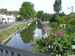
90:
85:
81:
80:
77:
73:
72:
68:
67:
64:
60:
59:
56:
52:
51:
50:Specifications
47:
46:
39:
31:
30:
15:
13:
10:
9:
6:
4:
3:
2:
598:
587:
584:
582:
579:
578:
576:
567:
564:
563:
559:
556:
555:
551:
547:
544:
543:
539:
530:
524:
520:
513:
511:
507:
500:
496:
493:
492:
488:
482:
476:
472:
470:
466:
464:
460:
458:
454:
452:
448:
446:
442:
440:
436:
434:
430:
428:
424:
422:
418:
416:
412:
410:
406:
404:
400:
397:
396:
395:
389:
387:
385:
377:
375:
373:
369:
364:
359:
357:
353:
349:
345:
341:
337:
329:
323:
319:
317:
313:
309:
305:
301:
297:
292:
284:
279:
271:
262:
258:
254:
250:
247:
243:
240:
237:
233:
228:
200:
198:
193:
190:
184:
156:
154:
149:
146:
143:
139:
136:
133:
129:
124:
120:
116:
112:
108:
104:
100:
96:
94:Date approved
92:
89:
86:
82:
78:
74:
69:
65:
61:
57:
53:
48:
43:
37:
32:
27:
22:
549:
518:
393:
381:
360:
333:
282:
269:
267:
76:Former names
245:Connects to
222: /
197:coordinates
178: /
153:coordinates
131:Start point
575:Categories
501:References
433:Montchanin
363:Charollais
356:Revolution
207:46°47′53″N
163:46°28′39″N
151:Beginning
336:Francis I
302:, to the
235:Branch of
210:4°52′48″E
166:3°58′50″E
141:End point
126:Geography
489:See also
461:PK 14.5
451:Santenay
449:PK 22.5
415:Génelard
344:Henry II
469:Fragnes
330:History
195:Ending
71:History
525:
457:Chagny
455:PK 17
443:PK 31
437:PK 42
431:PK 50
427:Blanzy
425:PK 59
419:PK 62
413:PK 80
407:PK 99
403:Digoin
378:Layout
312:France
296:Digoin
253:Digoin
189:Digoin
135:Digoin
55:Length
473:PK 0
467:PK 6
463:Rully
390:Route
304:Saône
257:Saône
63:Locks
523:ISBN
401:112
268:The
121:1792
113:1792
105:1784
97:1783
306:at
259:at
251:at
577::
509:^
399:PK
318:.
255:,
531:.
285:(
272:(
44:.
23:.
Text is available under the Creative Commons Attribution-ShareAlike License. Additional terms may apply.