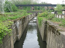
262:. The district was the site of many industrial operations during the 19th and early 20th centuries, fueled by the abundant hydraulic power created by the steep descent of the runoff from the parallel Crosby's Mill Race. Along with providing an industrial power source, canal operations provided ample time and traffic for commerce. With each lock, canal traffic stopped. There were 21 locks in the Akron area, and it took boats six hours to get through the two miles of canal. A popular establishment for canallers was located in the Cascade Locks area. Though it originally functioned as a cigar box plant with its own mill race, the Mustill Store was best known as a “swilling place” across from Lock 15. The 1913 flood brought an end to the canal. Several locks were dynamited to prevent inundating the downtown area. The most damaged area of the canal included the cascade locks. The canal commission determined the system was not salvageable. Water from the Summit Lake is controlled by
850:
62:
104:
79:
857:
111:
86:
328:
275:; two railroad bridges spanning the gorge; a steam plant and two rubber factories; numerous lock and waste way ruins. A footpath currently runs alongside the locks. The Ohio and Erie Canal towpath hike/bike trail is complete throughout the Cascade Lock Park and a bridge connect the trail from Harvard Avenue in
266:
by a dam/gate system at Lock 1 to prevent the disaster that happened in 1913. From there, it flows unimpeded over the locks and into the Little
Cuyahoga River. There are many varied buildings and sites within the district including the Mustill Store—now a visitor center and canal museum. The district
1006:
917:
819:
794:
684:
474:
699:
604:
514:
479:
454:
419:
829:
804:
789:
759:
749:
724:
714:
649:
619:
579:
569:
554:
549:
524:
504:
499:
489:
484:
464:
429:
375:
839:
734:
644:
624:
599:
584:
559:
519:
469:
449:
434:
414:
996:
814:
809:
784:
774:
769:
764:
744:
739:
709:
694:
689:
679:
669:
659:
654:
634:
589:
564:
544:
539:
534:
529:
444:
424:
991:
912:
824:
799:
779:
719:
704:
674:
664:
639:
629:
594:
574:
494:
459:
439:
409:
404:
834:
754:
729:
614:
609:
509:
896:
886:
891:
871:
876:
1011:
881:
368:
388:
361:
945:
940:
976:
148:
103:
981:
986:
922:
950:
48:
78:
1001:
384:
308:
235:
39:
246:
Located immediately northwest of downtown Akron, the
Cascade Locks Historic District is a ravine that opens up to a flat plane where the
61:
1016:
935:
955:
343:
313:
276:
251:
268:
280:
247:
132:
353:
337:
210:
970:
254:. This area of the canal included the steepest grade of the entire 304 miles between
272:
231:
136:
259:
332:
163:
150:
255:
1007:
Historic districts on the
National Register of Historic Places in Ohio
135:
and the canal from Locks 10 to 15, including discontiguous parts N,
303:
263:
357:
997:
National
Register of Historic Places in Summit County, Ohio
992:
Houses on the
National Register of Historic Places in Ohio
110:
85:
941:
History of the
National Register of Historic Places
905:
864:
395:
216:
203:
195:
187:
179:
142:
127:
1012:Locks on the National Register of Historic Places
267:also includes the site of the original mills of
369:
8:
199:Chicago, Greek Revival, The Commercial Style
279:to the Southern Boundary of urban Akron in
376:
362:
354:
60:
40:U.S. National Register of Historic Places
16:Historic district in Ohio, United States
977:Buildings and structures in Akron, Ohio
292:
304:"National Register Information System"
298:
296:
23:
7:
385:National Register of Historic Places
309:National Register of Historic Places
236:National Register of Historic Places
982:Chicago school architecture in Ohio
987:Greek Revival architecture in Ohio
230:is a historic district located in
131:Roughly bounded by North, Howard,
14:
855:
848:
331: This article incorporates
326:
109:
102:
84:
77:
339:Cascade Locks Historic District
228:Cascade Locks Historic District
32:Cascade Locks Historic District
205:
1:
1002:Houses in Summit County, Ohio
918:Cuyahoga Valley National Park
118:Show map of the United States
21:United States historic place
923:National Historic Landmarks
1033:
931:
846:
204:NRHP reference
71:
59:
55:
46:
37:
30:
26:
196:Architectural style
936:Keeper of the Register
333:public domain material
234:. It was added to the
49:U.S. Historic district
956:Contributing property
344:National Park Service
314:National Park Service
252:Little Cuyahoga River
183:25 acres (10 ha)
164:41.09306°N 81.52111°W
269:Ferdinand Schumacher
248:Ohio and Erie Canal
169:41.09306; -81.52111
160: /
133:Innerbelt Route 59
964:
963:
951:Historic district
316:. March 13, 2009.
250:empties into the
224:
223:
220:December 10, 1992
1024:
859:
858:
852:
851:
378:
371:
364:
355:
348:
347:
330:
329:
324:
318:
317:
300:
207:
175:
174:
172:
171:
170:
165:
161:
158:
157:
156:
153:
119:
113:
112:
106:
94:
93:Show map of Ohio
88:
87:
81:
64:
24:
1032:
1031:
1027:
1026:
1025:
1023:
1022:
1021:
967:
966:
965:
960:
927:
901:
860:
856:
854:
853:
849:
844:
397:
391:
382:
352:
351:
336:
327:
325:
321:
302:
301:
294:
289:
277:Cuyahoga County
244:
168:
166:
162:
159:
154:
151:
149:
147:
146:
123:
122:
121:
120:
117:
116:
115:
114:
97:
96:
95:
92:
91:
90:
89:
67:
51:
42:
33:
22:
17:
12:
11:
5:
1030:
1028:
1020:
1019:
1014:
1009:
1004:
999:
994:
989:
984:
979:
969:
968:
962:
961:
959:
958:
953:
948:
946:Property types
943:
938:
932:
929:
928:
926:
925:
920:
915:
909:
907:
903:
902:
900:
899:
894:
889:
884:
879:
874:
868:
866:
862:
861:
847:
845:
843:
842:
837:
832:
827:
822:
817:
812:
807:
802:
797:
792:
787:
782:
777:
772:
767:
762:
757:
752:
747:
742:
737:
732:
727:
722:
717:
712:
707:
702:
697:
692:
687:
682:
677:
672:
667:
662:
657:
652:
647:
642:
637:
632:
627:
622:
617:
612:
607:
602:
597:
592:
587:
582:
577:
572:
567:
562:
557:
552:
547:
542:
537:
532:
527:
522:
517:
512:
507:
502:
497:
492:
487:
482:
477:
472:
467:
462:
457:
452:
447:
442:
437:
432:
427:
422:
417:
412:
407:
401:
399:
393:
392:
383:
381:
380:
373:
366:
358:
350:
349:
319:
291:
290:
288:
285:
243:
240:
222:
221:
218:
214:
213:
208:
201:
200:
197:
193:
192:
189:
185:
184:
181:
177:
176:
144:
140:
139:
129:
125:
124:
108:
107:
101:
100:
99:
98:
83:
82:
76:
75:
74:
73:
72:
69:
68:
65:
57:
56:
53:
52:
47:
44:
43:
38:
35:
34:
31:
28:
27:
20:
15:
13:
10:
9:
6:
4:
3:
2:
1029:
1018:
1017:Locks of Ohio
1015:
1013:
1010:
1008:
1005:
1003:
1000:
998:
995:
993:
990:
988:
985:
983:
980:
978:
975:
974:
972:
957:
954:
952:
949:
947:
944:
942:
939:
937:
934:
933:
930:
924:
921:
919:
916:
914:
911:
910:
908:
904:
898:
895:
893:
890:
888:
885:
883:
880:
878:
875:
873:
870:
869:
867:
865:Lists by city
863:
841:
838:
836:
833:
831:
828:
826:
823:
821:
818:
816:
813:
811:
808:
806:
803:
801:
798:
796:
793:
791:
788:
786:
783:
781:
778:
776:
773:
771:
768:
766:
763:
761:
758:
756:
753:
751:
748:
746:
743:
741:
738:
736:
733:
731:
728:
726:
723:
721:
718:
716:
713:
711:
708:
706:
703:
701:
698:
696:
693:
691:
688:
686:
683:
681:
678:
676:
673:
671:
668:
666:
663:
661:
658:
656:
653:
651:
648:
646:
643:
641:
638:
636:
633:
631:
628:
626:
623:
621:
618:
616:
613:
611:
608:
606:
603:
601:
598:
596:
593:
591:
588:
586:
583:
581:
578:
576:
573:
571:
568:
566:
563:
561:
558:
556:
553:
551:
548:
546:
543:
541:
538:
536:
533:
531:
528:
526:
523:
521:
518:
516:
513:
511:
508:
506:
503:
501:
498:
496:
493:
491:
488:
486:
483:
481:
478:
476:
473:
471:
468:
466:
463:
461:
458:
456:
453:
451:
448:
446:
443:
441:
438:
436:
433:
431:
428:
426:
423:
421:
418:
416:
413:
411:
408:
406:
403:
402:
400:
394:
390:
386:
379:
374:
372:
367:
365:
360:
359:
356:
345:
341:
340:
334:
323:
320:
315:
311:
310:
305:
299:
297:
293:
286:
284:
282:
281:Summit County
278:
274:
270:
265:
261:
257:
253:
249:
241:
239:
237:
233:
229:
219:
217:Added to NRHP
215:
212:
209:
202:
198:
194:
190:
186:
182:
178:
173:
145:
141:
138:
134:
130:
126:
105:
80:
70:
63:
58:
54:
50:
45:
41:
36:
29:
25:
19:
338:
322:
307:
271:—founder of
245:
227:
225:
18:
906:Other lists
273:Quaker Oats
232:Akron, Ohio
167: /
143:Coordinates
137:Akron, Ohio
971:Categories
877:Cincinnati
820:Washington
795:Tuscarawas
685:Montgomery
475:Columbiana
287:References
260:Ohio River
155:81°31′16″W
882:Cleveland
700:Muskingum
605:Jefferson
515:Fairfield
480:Coshocton
455:Champaign
420:Ashtabula
398:by county
256:Lake Erie
238:in 1992.
152:41°5′35″N
897:Sandusky
887:Columbus
830:Williams
805:Van Wert
790:Trumbull
760:Sandusky
750:Richland
725:Pickaway
715:Paulding
650:Mahoning
620:Lawrence
580:Highland
570:Harrison
555:Hamilton
550:Guernsey
525:Franklin
505:Delaware
500:Defiance
490:Cuyahoga
485:Crawford
465:Clermont
430:Auglaize
211:92001627
128:Location
913:Bridges
840:Wyandot
735:Portage
645:Madison
625:Licking
600:Jackson
585:Hocking
560:Hancock
520:Fayette
470:Clinton
450:Carroll
435:Belmont
415:Ashland
258:to the
242:History
66:Lock 14
892:Dayton
815:Warren
810:Vinton
785:Summit
775:Shelby
770:Seneca
765:Scioto
745:Putnam
740:Preble
710:Ottawa
695:Morrow
690:Morgan
680:Monroe
670:Mercer
660:Medina
655:Marion
635:Lorain
590:Holmes
565:Hardin
545:Greene
540:Geauga
535:Gallia
530:Fulton
445:Butler
425:Athens
872:Akron
825:Wayne
800:Union
780:Stark
720:Perry
705:Noble
675:Miami
665:Meigs
640:Lucas
630:Logan
595:Huron
575:Henry
495:Darke
460:Clark
440:Brown
410:Allen
405:Adams
396:Lists
335:from
188:Built
835:Wood
755:Ross
730:Pike
615:Lake
610:Knox
510:Erie
389:Ohio
264:ODNR
226:The
191:1827
180:Area
387:in
206:No.
973::
342:.
312:.
306:.
295:^
283:.
377:e
370:t
363:v
346:.
Text is available under the Creative Commons Attribution-ShareAlike License. Additional terms may apply.