102:
25:
119:
149:
1071:
156:
126:
351:
441:, covering approximately 200,000 km (77,000 sq mi). The area is very rich in underground oil and gas reserves, and oil and natural gas pipelines cross the depression from north to south and east to west. Many
379:
flow into the
Caspian Sea through this region. The deltas of the Ural and Volga Rivers are extensive wetlands. The main rivers of the lowland beside the Volga and the Ural are the
472:
toward the
Caspian Sea. Russian satellite photos have revealed huge deposits of salt domes (about 1,200), in the Caspian Depression in western Kazakhstan. One dome, called the
101:
449:
forces. Some of them also believe that the North
Caspian depression became separated from the open ocean in ancient times to form an enormous salt lake. Part of the ancient
712:
479:
The southern region of the depression, or the north coast of the
Caspian Sea, is characterized by the large development of damp sites resulting from
1565:
265:
The level of the
Caspian sea is 28 metres (92 ft) below sea level, however several areas in the depression are even lower, and among them
515:
629:
118:
181:
46:
148:
1269:
772:
68:
1610:
705:
1741:
1362:
1141:
1013:
792:
650:
430:. The area receives 300 mm (12 in) of rain per year, on average, and less than 10% of the region is irrigated.
1736:
1670:
1312:
1297:
831:
802:
1726:
1023:
490:, with several thousand different species likely living in the region around the Caspian Sea. Studies have shown that
39:
33:
1058:
926:
921:
698:
1342:
50:
1470:
1392:
1239:
886:
1680:
1249:
255:
1731:
1254:
1186:
998:
557:
529:
302:
1422:
968:
916:
896:
871:
757:
476:, covers an area of 3,237 km (1,250 sq mi) and is nearly 8 kilometres (5 mi) deep.
346:
1523:
1518:
1181:
1038:
936:
891:
473:
282:
92:
364:(a.k.a. Cis-Ural Plateau, Pre-Ural Plateau, Poduralskoe Plateau) It significantly overlaps with the
1665:
1620:
1595:
1552:
1417:
1352:
1322:
1214:
1126:
1106:
1048:
1043:
1028:
983:
978:
953:
941:
819:
777:
729:
419:
286:
1690:
1570:
1224:
1219:
1151:
1116:
1018:
1008:
958:
906:
856:
851:
846:
836:
814:
809:
797:
782:
767:
762:
752:
747:
742:
737:
510:
684:
1650:
1503:
1307:
1053:
1003:
993:
973:
963:
948:
931:
911:
881:
876:
865:
841:
826:
787:
721:
644:
499:
404:
1538:
1685:
1533:
1450:
1347:
1196:
1171:
1166:
1146:
1136:
1111:
1079:
1033:
988:
901:
861:
589:
577:
361:
326:
322:
306:
1660:
1560:
1455:
1402:
1367:
1332:
1191:
1176:
1161:
1131:
1096:
1070:
572:
548:
491:
357:
1615:
1605:
1590:
1460:
1445:
1437:
1432:
1372:
1287:
1264:
1206:
1156:
1121:
1101:
663:
330:
318:
1720:
1705:
1645:
1630:
1600:
1575:
1475:
1465:
1382:
1337:
1279:
1244:
388:
384:
298:
247:
1695:
1528:
1387:
1292:
1229:
503:
495:
438:
396:
380:
338:
334:
468:, particularly Volgograd salt. It increases dramatically as one travels from the
1675:
1485:
1480:
1407:
1377:
372:
243:
1655:
1635:
1357:
469:
408:
392:
376:
365:
290:
196:
183:
1580:
1397:
1302:
465:
454:
450:
442:
434:
423:
16:
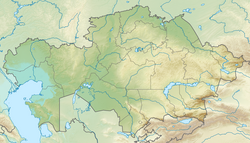
Low-lying flatland region encompassing the northern part of the
Caspian Sea
1585:
1508:
632:. Caspian Environment Programme. Archived from the original on 2006-04-08
446:
433:
The
Caspian Depression is below sea level, consisting of large areas of
314:
310:
266:
259:
1700:
1640:
1625:
1513:
1495:
1259:
1088:
487:
461:
in
Kazakhstan. Today, the region is used mainly for livestock raising.
400:
342:
236:
453:
ran through this region. The two largest cities in the depression are
437:
in the eastern region. It is one of the largest flat lowland areas in
484:
458:
412:
294:
690:
498:
of the
Caspian Depression. Water pollution is contributed mainly by
494:, mostly coming from the Volga River, poses a serious threat to the
427:
270:
251:
239:
1234:
480:
694:
106:
Caspian
Depression and north Caspian Sea from space. NASA photo
18:
445:
believe the Caspian Sea and the depression were formed by
677:
Evaporites of North Border of North Caspian Depression –
562:
1551:
1494:
1431:
1321:
1278:
1205:
1087:
1078:
728:
217:
212:
83:
483:phenomena. The depression is also home to many
391:. There are also numerous salt lakes, such as
254:. It is the larger northern part of the wider
706:
273:is the lowest at −132 metres (−433 ft).
242:region encompassing the northern part of the
8:
418:The North Caspian depression is part of the
594:
1084:
713:
699:
691:
604:Pricaspian/Peri-Caspian Depression/Lowland
590:[prʲɪkɐˈspʲijskəjəˈnʲizmʲɪnnəsʲtʲ]
155:
125:
80:
69:Learn how and when to remove this message
221:200,000 km (77,000 sq mi)
32:This article includes a list of general
621:
541:
509:The highest point in the depression is
211:
110:
98:
642:
588:
571:
216:
7:
679:Internet Geology News Letter No. 178
297:. In Kazakhstan it covers parts of
285:is in the northeastern part of the
38:it lacks sufficient corresponding
14:
464:The depression is also noted for
1069:
333:. In the Horth it is bounded by
154:
147:
124:
117:
100:
23:
630:"Caspian Sea » Background"
573:[kɐsˈpʲijmɑŋˈəwojpɑˈtə]
309:. In Russia it covers parts of
1:
1363:European Cenozoic Rift System
520:(152m above the sea level).
506:, and household discharges.
1553:UNESCO World Heritage Sites
563:
1758:
668:Great Russian Encyclopedia
1067:
664:Прикаспийская низменность
649:: CS1 maint: unfit URL (
582:Прикаспийская низменность
581:
552:
337:highland; in the West by
177:
111:
99:
90:
1471:Jan Mayen Microcontinent
1413:Peri-Caspian Depression
1142:Hallandian-Danopolonian
256:Aral-Caspian Depression
246:, the largest enclosed
53:more precise citations.
1255:Scandinavian Mountains
773:Bosnia and Herzegovina
530:Caspian lowland desert
303:West Kazakhstan Region
138:Show map of Kazakhstan
1742:Depressions of Europe
1423:White Sea Rift System
1529:Fennoscandian Craton
1524:East European Craton
289:and covers parts of
1737:East European Plain
1418:Timan-Pechora Basin
1353:Dnieper–Donets Rift
1270:Western Carpathians
681:, January 13, 2003.
287:East European Plain
193: /
1727:Caspian Depression
1571:Calanques de Piana
1325:basins and grabens
685:Space Today Online
564:Kaspii mañy oipaty
553:Каспий маңы ойпаты
262:and Caspian Seas.
229:Caspian Depression
218: • Total
168:Show map of Russia
162:Caspian Depression
132:Caspian Depression
85:Caspian Depression
1714:
1713:
1651:Monte San Giorgio
1547:
1546:
1504:Armorican terrane
1308:Mediterranean Sea
722:Geology of Europe
561:
405:Kamys-Samar Lakes
356:; in the east by
225:
224:
79:
78:
71:
1749:
1611:Jungfrau-Aletsch
1596:Giant's Causeway
1534:Sarmatian Craton
1451:Aegean Sea Plate
1348:Central Lowlands
1343:Baltic Sea Basin
1323:Intracontinental
1085:
1080:Geologic regions
1073:
1024:Northern Ireland
715:
708:
701:
692:
670:
661:
655:
654:
648:
640:
638:
637:
626:
609:
608:
605:
602:
599:
596:
592:
587:
583:
575:
570:
566:
556:
554:
546:
519:
362:Sub-Ural Plateau
355:
347:Stavropol Upland
327:Astrakhan Oblast
323:Volgograd Oblast
307:Mangystau Region
208:
207:
205:
204:
203:
198:
194:
191:
190:
189:
186:
169:
158:
157:
151:
139:
128:
127:
121:
104:
81:
74:
67:
63:
60:
54:
49:this article by
40:inline citations
27:
26:
19:
1757:
1756:
1752:
1751:
1750:
1748:
1747:
1746:
1717:
1716:
1715:
1710:
1561:Aeolian Islands
1543:
1490:
1456:Anatolian Plate
1438:microcontinents
1436:
1433:Tectonic plates
1427:
1403:Pannonian Basin
1393:North Sea Basin
1368:Hellenic Trench
1333:Aquitaine Basin
1324:
1317:
1274:
1207:Mountain ranges
1201:
1074:
1065:
927:North Macedonia
724:
719:
674:
673:
662:
658:
641:
635:
633:
628:
627:
623:
618:
613:
612:
606:
603:
600:
597:
585:
568:
547:
543:
538:
526:
513:
492:water pollution
474:Chelkar Deposit
358:Ustyurt Plateau
349:
279:
233:Caspian Lowland
201:
199:
195:
192:
187:
184:
182:
180:
179:
173:
172:
171:
170:
167:
166:
165:
164:
163:
159:
142:
141:
140:
137:
136:
135:
134:
133:
129:
107:
95:
86:
75:
64:
58:
55:
45:Please help to
44:
28:
24:
17:
12:
11:
5:
1755:
1753:
1745:
1744:
1739:
1734:
1729:
1719:
1718:
1712:
1711:
1709:
1708:
1703:
1698:
1693:
1688:
1683:
1678:
1673:
1668:
1663:
1658:
1653:
1648:
1643:
1638:
1633:
1628:
1623:
1618:
1616:Jurassic Coast
1613:
1608:
1603:
1598:
1593:
1591:Geirangerfjord
1588:
1583:
1578:
1573:
1568:
1563:
1557:
1555:
1549:
1548:
1545:
1544:
1542:
1541:
1536:
1531:
1526:
1521:
1516:
1511:
1506:
1500:
1498:
1492:
1491:
1489:
1488:
1483:
1478:
1473:
1468:
1463:
1461:Eurasian Plate
1458:
1453:
1448:
1446:Adriatic Plate
1442:
1440:
1429:
1428:
1426:
1425:
1420:
1415:
1410:
1405:
1400:
1395:
1390:
1385:
1380:
1375:
1373:Limagne Graben
1370:
1365:
1360:
1355:
1350:
1345:
1340:
1335:
1329:
1327:
1319:
1318:
1316:
1315:
1310:
1305:
1300:
1295:
1290:
1288:Atlantic Ocean
1284:
1282:
1280:Oceanic basins
1276:
1275:
1273:
1272:
1267:
1262:
1257:
1252:
1247:
1242:
1240:Massif Central
1237:
1232:
1227:
1222:
1217:
1211:
1209:
1203:
1202:
1200:
1199:
1194:
1189:
1187:Sveconorwegian
1184:
1179:
1174:
1169:
1164:
1159:
1154:
1149:
1144:
1139:
1134:
1129:
1124:
1119:
1114:
1109:
1104:
1099:
1093:
1091:
1082:
1076:
1075:
1068:
1066:
1064:
1063:
1062:
1061:
1056:
1051:
1046:
1041:
1036:
1031:
1026:
1021:
1014:United Kingdom
1011:
1006:
1001:
996:
991:
986:
981:
976:
971:
966:
961:
956:
951:
946:
945:
944:
939:
929:
924:
919:
914:
909:
904:
899:
894:
889:
884:
879:
874:
869:
859:
854:
849:
844:
839:
834:
829:
824:
823:
822:
812:
807:
806:
805:
795:
793:Czech Republic
790:
785:
780:
775:
770:
765:
760:
755:
750:
745:
740:
734:
732:
726:
725:
720:
718:
717:
710:
703:
695:
689:
688:
682:
672:
671:
656:
620:
619:
617:
614:
611:
610:
540:
539:
537:
534:
533:
532:
525:
522:
457:in Russia and
331:Stavropol Krai
319:Saratov Oblast
278:
275:
223:
222:
219:
215:
214:
210:
209:
175:
174:
161:
160:
153:
152:
146:
145:
144:
143:
131:
130:
123:
122:
116:
115:
114:
113:
112:
109:
108:
105:
97:
96:
91:
88:
87:
84:
77:
76:
31:
29:
22:
15:
13:
10:
9:
6:
4:
3:
2:
1754:
1743:
1740:
1738:
1735:
1733:
1732:Lowest points
1730:
1728:
1725:
1724:
1722:
1707:
1704:
1702:
1699:
1697:
1694:
1692:
1689:
1687:
1684:
1682:
1679:
1677:
1674:
1672:
1669:
1667:
1664:
1662:
1659:
1657:
1654:
1652:
1649:
1647:
1646:Monte Perdido
1644:
1642:
1639:
1637:
1634:
1632:
1629:
1627:
1624:
1622:
1619:
1617:
1614:
1612:
1609:
1607:
1604:
1602:
1599:
1597:
1594:
1592:
1589:
1587:
1584:
1582:
1579:
1577:
1576:Curonian Spit
1574:
1572:
1569:
1567:
1564:
1562:
1559:
1558:
1556:
1554:
1550:
1540:
1537:
1535:
1532:
1530:
1527:
1525:
1522:
1520:
1517:
1515:
1512:
1510:
1507:
1505:
1502:
1501:
1499:
1497:
1493:
1487:
1484:
1482:
1479:
1477:
1476:Moesian Plate
1474:
1472:
1469:
1467:
1466:Iberian Plate
1464:
1462:
1459:
1457:
1454:
1452:
1449:
1447:
1444:
1443:
1441:
1439:
1434:
1430:
1424:
1421:
1419:
1416:
1414:
1411:
1409:
1406:
1404:
1401:
1399:
1396:
1394:
1391:
1389:
1386:
1384:
1383:Molasse Basin
1381:
1379:
1376:
1374:
1371:
1369:
1366:
1364:
1361:
1359:
1356:
1354:
1351:
1349:
1346:
1344:
1341:
1339:
1338:Barents Basin
1336:
1334:
1331:
1330:
1328:
1326:
1320:
1314:
1313:Norwegian Sea
1311:
1309:
1306:
1304:
1301:
1299:
1298:Bay of Biscay
1296:
1294:
1291:
1289:
1286:
1285:
1283:
1281:
1277:
1271:
1268:
1266:
1263:
1261:
1258:
1256:
1253:
1251:
1248:
1246:
1245:Ore Mountains
1243:
1241:
1238:
1236:
1233:
1231:
1228:
1226:
1223:
1221:
1218:
1216:
1213:
1212:
1210:
1208:
1204:
1198:
1195:
1193:
1190:
1188:
1185:
1183:
1180:
1178:
1175:
1173:
1170:
1168:
1165:
1163:
1160:
1158:
1155:
1153:
1150:
1148:
1145:
1143:
1140:
1138:
1135:
1133:
1130:
1128:
1125:
1123:
1120:
1118:
1115:
1113:
1110:
1108:
1105:
1103:
1100:
1098:
1095:
1094:
1092:
1090:
1086:
1083:
1081:
1077:
1072:
1060:
1057:
1055:
1052:
1050:
1047:
1045:
1042:
1040:
1037:
1035:
1032:
1030:
1027:
1025:
1022:
1020:
1017:
1016:
1015:
1012:
1010:
1007:
1005:
1002:
1000:
997:
995:
992:
990:
987:
985:
982:
980:
977:
975:
972:
970:
967:
965:
962:
960:
957:
955:
952:
950:
947:
943:
940:
938:
935:
934:
933:
930:
928:
925:
923:
920:
918:
915:
913:
910:
908:
905:
903:
900:
898:
895:
893:
890:
888:
887:Liechtenstein
885:
883:
880:
878:
875:
873:
870:
867:
863:
860:
858:
855:
853:
850:
848:
845:
843:
840:
838:
835:
833:
830:
828:
825:
821:
820:Åland Islands
818:
817:
816:
813:
811:
808:
804:
803:Faroe Islands
801:
800:
799:
796:
794:
791:
789:
786:
784:
781:
779:
776:
774:
771:
769:
766:
764:
761:
759:
756:
754:
751:
749:
746:
744:
741:
739:
736:
735:
733:
731:
727:
723:
716:
711:
709:
704:
702:
697:
696:
693:
686:
683:
680:
676:
675:
669:
665:
660:
657:
652:
646:
631:
625:
622:
615:
591:
579:
574:
565:
559:
550:
545:
542:
535:
531:
528:
527:
523:
521:
517:
512:
507:
505:
501:
497:
493:
489:
486:
482:
477:
475:
471:
467:
462:
460:
456:
452:
448:
444:
440:
436:
431:
429:
425:
421:
416:
414:
410:
406:
402:
398:
394:
390:
386:
382:
378:
374:
369:
367:
363:
359:
353:
348:
344:
340:
336:
332:
328:
324:
320:
316:
312:
308:
304:
300:
299:Atyrau Region
296:
292:
288:
284:
276:
274:
272:
268:
263:
261:
257:
253:
249:
248:body of water
245:
241:
238:
234:
230:
220:
206:
178:Coordinates:
176:
150:
120:
103:
94:
89:
82:
73:
70:
62:
59:February 2008
52:
48:
42:
41:
35:
30:
21:
20:
1696:Stevns Klint
1539:Volgo–Uralia
1412:
1388:Moscow Basin
1293:Arctic Ocean
1230:Dinaric Alps
1182:Svecofennian
678:
667:
659:
634:. Retrieved
624:
544:
508:
504:agricultural
496:biodiversity
478:
463:
439:Central Asia
432:
417:
370:
339:Volga Upland
335:Obshchy Syrt
280:
264:
232:
228:
226:
197:47.53°N 49°E
65:
56:
37:
1706:Thingvellir
1676:Rhine Gorge
1486:Tisza Plate
1481:Pelso Plate
1408:Paris Basin
1378:Mezen Basin
1127:Dalslandian
1059:Isle of Man
999:Switzerland
922:Netherlands
514: [
511:Mount Bogdo
420:continental
373:Volga River
350: [
258:around the
244:Caspian Sea
200: /
51:introducing
1721:Categories
1661:Nærøyfjord
1656:Mount Etna
1636:Messel Pit
1606:High Coast
1358:Ebro Basin
1152:Laxfordian
1122:Carpathian
1117:Caledonian
1107:Belomorian
969:San Marino
917:Montenegro
897:Luxembourg
872:Kazakhstan
758:Azerbaijan
636:2011-02-24
616:References
500:industrial
470:Ryn Desert
466:salt domes
443:geologists
435:marshlands
393:Baskunchak
377:Ural River
366:Ryn Desert
291:Kazakhstan
283:depression
93:Depression
34:references
1581:Dolomites
1398:Oslo Rift
1303:Black Sea
1220:Apennines
1039:Gibraltar
937:Jan Mayen
892:Lithuania
730:Countries
558:romanized
455:Astrakhan
451:Silk Road
424:semi-arid
277:Geography
237:low-lying
202:47.53; 49
1691:St Kilda
1681:Scandola
1671:Plitvice
1586:Durmitor
1566:Aggtelek
1519:Cimmeria
1509:Avalonia
1496:Terranes
1250:Pyrenees
1225:Caucasus
1197:Variscan
1177:Timanide
1172:Scourian
1167:Scandian
1147:Hellenic
1137:Grampian
1112:Cadomian
1049:Guernsey
1044:Alderney
1029:Scotland
984:Slovenia
979:Slovakia
954:Portugal
942:Svalbard
778:Bulgaria
645:cite web
524:See also
447:tectonic
375:and the
315:Kalmykia
311:Dagestan
267:Karagiye
240:flatland
1701:Surtsey
1686:Škocjan
1641:Meteora
1631:Laponia
1626:Kvarken
1514:Baltica
1260:Sudetes
1192:Uralian
1162:Saamian
1132:Gothian
1097:Acadian
1089:Orogens
1019:England
1009:Ukraine
959:Romania
907:Moldova
857:Ireland
852:Iceland
847:Hungary
837:Germany
832:Georgia
815:Finland
810:Estonia
798:Denmark
783:Croatia
768:Belgium
763:Belarus
753:Austria
748:Armenia
743:Andorra
738:Albania
598:
578:Russian
560::
488:species
426:desert
401:Aralsor
343:Yergeni
231:or the
188:49°00′E
185:47°32′N
47:improve
1601:Glarus
1157:Lopian
1102:Alpine
1054:Jersey
1004:Turkey
994:Sweden
974:Serbia
964:Russia
949:Poland
932:Norway
912:Monaco
882:Latvia
877:Kosovo
866:Sicily
842:Greece
827:France
788:Cyprus
549:Kazakh
485:insect
459:Atyrau
413:Botkul
345:, and
329:, and
305:, and
295:Russia
36:, but
1666:Pirin
1265:Urals
1034:Wales
989:Spain
902:Malta
862:Italy
536:Notes
518:]
481:tidal
428:biome
409:Elton
397:Inder
385:Terek
354:]
271:Aktau
269:near
252:Earth
235:is a
1621:Komi
1235:Harz
1215:Alps
651:link
595:lit.
586:IPA:
569:IPA:
411:and
389:Kuma
387:and
381:Emba
371:The
360:and
293:and
281:The
260:Aral
227:The
213:Area
1435:and
422:or
250:on
1723::
666:,
647:}}
643:{{
593:;
584:,
580::
576:;
567:,
555:,
551::
516:ru
502:,
415:.
407:,
403:,
399:,
395:,
383:,
368:.
352:ru
341:,
325:,
321:,
317:,
313:,
301:,
868:)
864:(
714:e
707:t
700:v
687:.
653:)
639:.
607:'
601:'
72:)
66:(
61:)
57:(
43:.
Text is available under the Creative Commons Attribution-ShareAlike License. Additional terms may apply.