166:
31:
657:
174:
196:
The rock formation is mentioned in the magazine "New
Zealand Journal of Geology and Geophysics 1967 Vol.10 No.4" by PJ Barrett, where he mentions the pebble band in the flaggy limestone. In March, 2019 the surrounding farm hosted a 250 km 4WD off-road race organised by the Waikato Off Road
304:
158:
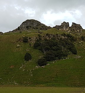
Limestone (sandstone). It stands 610 feet (186m) above sea level and provides an expansive view of Castle Craig Farm, an organic beef farm, plus the little town of
698:
382:
181:
In the 1920s the owner of Castle Craig Farm, which is where the rock is located, named it Castle Craig Rock because he thought it looked very similar to
83:
722:
278:
727:
691:
375:
230:
564:
76:
717:
684:
559:
518:
368:
206:
620:
610:
574:
569:
584:
554:
538:
66:
56:
579:
432:
404:
339:
256:
594:
452:
165:
30:
457:
298:
656:
615:
508:
391:
123:
589:
528:
282:
173:
668:
636:
523:
151:
139:
711:
513:
533:
472:
437:
408:
395:
360:
182:
127:
355:
319:
186:
98:
85:
159:
155:
482:
447:
442:
190:
147:
664:
487:
467:
462:
427:
422:
324:
143:
146:
region of New
Zealand. It is located 9 kilometres (5.6 mi) from
46:
477:
172:
164:
364:
340:"Castle Craig 250Km Enduro – Waitomo 30th March | WORC"
672:
629:
603:
547:
496:
415:
119:
114:
75:
65:
55:
45:
40:
23:
138:is a prominent geological feature to the south of
150:, Waikato, New Zealand, above the valley of the
250:
248:
692:
376:
235:New Zealand Journal of Geology and Geophysics
8:
303:: CS1 maint: numeric names: authors list (
699:
685:
383:
369:
361:
272:
270:
20:
225:
223:
221:
16:Rock in the Waikato region of New Zealand
217:
296:
169:View of Castle Craig Rock from behind
7:
653:
651:
14:
154:. Castle Craig Rock is a type of
655:
29:
1:
671:. You can help Knowledge by
565:Poro-O-Tarao railway station
744:
723:Rock formations of Waikato
650:
548:Facilities and attractions
356:View seen from Stone Table
560:Mangapehi railway station
519:Mangapohue Natural Bridge
402:
207:Mangapohue Natural Bridge
28:
575:Te Kuiti railway station
570:Puketutu railway station
51:186 m (610 ft)
728:Waikato geography stubs
667:geography article is a
585:Waiteti railway station
177:Castlecraig, Black Isle
555:Kopaki railway station
539:Waitomo Glowworm Caves
178:
170:
580:Wairere Power Station
433:Maniaiti / Benneydale
176:
168:
99:38.2594°S 174.8213°E
595:Waitomo Caves Hotel
497:Geographic features
261:mountainproject.com
95: /
179:
171:
104:-38.2594; 174.8213
41:Highest point
680:
679:
645:
644:
504:Castle Craig Rock
136:Castle Craig Rock
133:
132:
35:Castle Craig Rock
24:Castle Craig Rock
735:
718:Waitomo District
701:
694:
687:
659:
652:
621:Regional Council
611:District Council
416:Populated places
392:Waitomo District
385:
378:
371:
362:
344:
343:
336:
330:
329:
315:
309:
308:
302:
294:
292:
290:
281:. Archived from
274:
265:
264:
252:
243:
242:
241:(4): 1020. 1967.
227:
124:Waikato District
110:
109:
107:
106:
105:
100:
96:
93:
92:
91:
88:
33:
21:
743:
742:
738:
737:
736:
734:
733:
732:
708:
707:
706:
705:
648:
646:
641:
625:
599:
590:Waiteti Viaduct
543:
529:Rangitoto Range
492:
411:
398:
389:
352:
347:
338:
337:
333:
320:"YouTube Video"
318:Craig, Castle.
317:
316:
312:
295:
288:
286:
285:on 1 April 2019
279:"Off Road Race"
276:
275:
268:
257:"Rock Climbing"
255:Craig, Castle.
254:
253:
246:
229:
228:
219:
215:
203:
103:
101:
97:
94:
89:
86:
84:
82:
81:
36:
17:
12:
11:
5:
741:
739:
731:
730:
725:
720:
710:
709:
704:
703:
696:
689:
681:
678:
677:
660:
643:
642:
640:
639:
637:Piopio College
633:
631:
627:
626:
624:
623:
618:
613:
607:
605:
601:
600:
598:
597:
592:
587:
582:
577:
572:
567:
562:
557:
551:
549:
545:
544:
542:
541:
536:
531:
526:
524:Marokopa Falls
521:
516:
511:
506:
500:
498:
494:
493:
491:
490:
485:
480:
475:
470:
465:
460:
455:
450:
445:
440:
435:
430:
425:
419:
417:
413:
412:
403:
400:
399:
390:
388:
387:
380:
373:
365:
359:
358:
351:
350:External links
348:
346:
345:
331:
310:
266:
244:
216:
214:
211:
210:
209:
202:
199:
152:Marokopa River
140:Kawhia Harbour
131:
130:
121:
117:
116:
112:
111:
79:
73:
72:
69:
63:
62:
59:
53:
52:
49:
43:
42:
38:
37:
34:
26:
25:
15:
13:
10:
9:
6:
4:
3:
2:
740:
729:
726:
724:
721:
719:
716:
715:
713:
702:
697:
695:
690:
688:
683:
682:
676:
674:
670:
666:
661:
658:
654:
649:
638:
635:
634:
632:
630:Organisations
628:
622:
619:
617:
614:
612:
609:
608:
606:
602:
596:
593:
591:
588:
586:
583:
581:
578:
576:
573:
571:
568:
566:
563:
561:
558:
556:
553:
552:
550:
546:
540:
537:
535:
532:
530:
527:
525:
522:
520:
517:
515:
514:Lake Harihari
512:
510:
509:Gardner's Gut
507:
505:
502:
501:
499:
495:
489:
486:
484:
481:
479:
476:
474:
471:
469:
466:
464:
461:
459:
456:
454:
451:
449:
446:
444:
441:
439:
436:
434:
431:
429:
426:
424:
421:
420:
418:
414:
410:
406:
401:
397:
393:
386:
381:
379:
374:
372:
367:
366:
363:
357:
354:
353:
349:
341:
335:
332:
327:
326:
321:
314:
311:
306:
300:
284:
280:
273:
271:
267:
262:
258:
251:
249:
245:
240:
236:
232:
226:
224:
222:
218:
212:
208:
205:
204:
200:
198:
197:Racing Club.
194:
192:
188:
184:
175:
167:
163:
161:
157:
153:
149:
145:
141:
137:
129:
125:
122:
118:
113:
108:
80:
78:
74:
70:
68:
64:
60:
58:
54:
50:
48:
44:
39:
32:
27:
22:
19:
673:expanding it
662:
647:
534:Ruakuri Cave
503:
334:
323:
313:
287:. Retrieved
283:the original
260:
238:
234:
195:
189:in northern
180:
135:
134:
18:
396:New Zealand
277:Race, 4WD.
183:Castlecraig
128:New Zealand
102: /
90:174°49′17″E
77:Coordinates
71:Stone Table
67:Parent peak
712:Categories
604:Government
213:References
187:Black Isle
87:38°15′34″S
57:Prominence
458:Rangitoto
231:"Journal"
160:Awamarino
115:Geography
47:Elevation
483:Waikawau
473:Te Kūiti
443:Marokopa
438:Māhoenui
409:Te Kūiti
299:cite web
201:See also
191:Scotland
148:Marokopa
120:Location
665:Waikato
488:Waitomo
468:Te Anga
463:Taharoa
428:Awakino
325:YouTube
289:1 April
144:Waikato
142:in the
453:Piopio
156:flaggy
663:This
616:Mayor
478:Tiroa
448:Mōkau
61:180 m
669:stub
423:Āria
405:Seat
305:link
291:2019
185:in
714::
407::
394:,
322:.
301:}}
297:{{
269:^
259:.
247:^
239:10
237:.
233:.
220:^
193:.
162:.
126:,
700:e
693:t
686:v
675:.
384:e
377:t
370:v
342:.
328:.
307:)
293:.
263:.
Text is available under the Creative Commons Attribution-ShareAlike License. Additional terms may apply.