497:
505:
214:
33:
246:
198:
253:
221:
585:
at the airport before their deployment overseas. New
Cumberland Army depot remains although it has gone through several name changes over the years. It has been known as Defense Distribution Center (DDC) New Cumberland, Defense Distribution Region East (DDRE), and the Defense Distribution Supply
561:
which became TWA and remained until 1968. (DC-9s replaced TWA's last
Constellations in 1967; the 4970-ft runway was one of the shortest in the country to see airline jets.) Allegheny and Capital/United appeared in the 1940s; United pulled out in 1966.
1055:
1050:
586:
Point (DDSP) Susquehanna. Currently it is known as the
Defense Logistics Agency (DLA) Susquehanna, one of the largest military distribution centers for supplies and equipment for the
1006:
887:
577:
stationed the 101st and 103d
Observation Squadrons at Harrisburg early in the war to train pilots in observation and aerial photography. Later the Army Air Force formed the
514:
Capital City
Airport covers 320 acres (130 ha) and has two asphalt runways: 8/26 is 5,000 x 150 ft (1,524 x 46 m) and 12/30 is 3,778 x 100 ft (1,152 x 30 m).
486:
A study by the PA Department of
Transportation in 2000 concluded that Capital City Airport related activities generate nearly $ 24 million a year in economic output.
149:
420:
120:
914:
607:
471:
100:
880:
641:
596:
610:(SARAA). CXY is the designated reliever and sister airport of Harrisburg International Airport, and serves Dauphin, Cumberland, and York counties.
443:
213:
783:
682:
873:
245:
496:
508:
The airport (upper left) and vicinity on July 6, 2022; taken from the
International Space Station with north oriented towards the right.
570:
626:
crashed on approach when it flew into the side of a hill, 5km (3.1 miles) SW of CXY. Twelve occupants out of 27 on board were killed.
1045:
533:
Originally
Capital Landing Field, the airport opened in mid-1930 and was Harrisburg's first airline airport. On October 25, 1930, a
966:
956:
930:
636:
600:
475:
987:
951:
504:
439:
405:
376:
66:
574:
142:
124:
971:
961:
470:. It averages more than 57,000 corporate, charter, and private aircraft operations a year. Owned and operated by the
554:
549:
purchased it and renamed it
Harrisburg-York State Airport. It was a stop on longer air routes, principally between
566:
542:
467:
32:
807:
669:
550:
424:
110:
762:
592:
132:
197:
665:
525:. 97 aircraft were based at the airport: 74 single-engine, 13 multi-engine, 6 jet, and 4 military.
435:
408:
69:
819:
517:
In the year ending May 3, 2023, the airport had 27,348 aircraft operations, average 75 a day: 88%
481:
992:
686:
758:
778:
900:
587:
582:
397:
389:
55:
44:
578:
518:
447:
320:
734:
603:. Capital City Airport then got its current name and became a general aviation airport.
446:, but Capital City Airport is CXY to the FAA and HAR to the IATA (which assigned CXY to
835:
451:
1039:
865:
534:
623:
546:
428:
839:
825:
789:
466:
The airport is the home airport for the
Pennsylvania Bureau of Aviation and the
1021:
1008:
164:
151:
845:
829:
599:
was also close, and in 1968 Allegheny and TWA moved there to newly named
538:
522:
474:, Capital City Airport is the designated reliever and sister airport of
896:
565:
In the 1940s the airport handled war materials for the former adjacent
455:
416:
500:
Cropped from the photo underneath; north is oriented towards the right
813:
708:
290:
277:
1056:
Transportation buildings and structures in York County, Pennsylvania
849:
606:
Since 1999 Capital City Airport has been owned and operated by the
620:
503:
495:
869:
856:
1051:
Airfields of the United States Army Air Forces in Pennsylvania
795:
558:
184:
478:, and serves Dauphin, Cumberland, and York counties.
980:
939:
923:
907:
472:
Susquehanna Area Regional Airport Authority (SARAA)
361:
353:
344:
276:
190:
180:
141:
130:
116:
106:
96:
88:
83:
23:
571:Naval Photographic Reconnaissance Training School
881:
683:"Harrisburg Jet Center: Capital City Airport"
434:Most U.S. airports use the same three-letter
8:
421:Fairview Township, York County, Pennsylvania
18:Airport in near New Cumberland, Pennsylvania
915:Susquehanna Area Regional Airport Authority
608:Susquehanna Area Regional Airport Authority
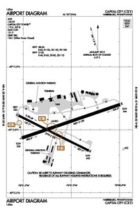
537:airplane flying the first transcontinental
101:Susquehanna Area Regional Airport Authority
888:
874:
866:
354:Aircraft operations (year ending 5/3/2023)
350:
20:
642:Pennsylvania World War II Army Airfields
653:
423:, three miles (5 km) southeast of
759:Accident description for 42-23360
661:
659:
657:
559:Transcontinental and Western Airlines
7:
739:Historical Society of Dauphin County
541:stopped at the airport. In 1934 the
786:at Pennsylvania Bureau of Aviation
765:. Retrieved on September 29, 2023.
14:
715:. Federal Aviation Administration
957:Franklin County Regional Airport
931:Harrisburg International Airport
637:List of airports in Pennsylvania
601:Harrisburg International Airport
476:Harrisburg International Airport
251:
244:
219:
212:
196:
31:
988:Olmsted Air National Guard Base
834:NOAA/NWS weather observations:
377:Federal Aviation Administration
95:
121:Fairview Township, York County
1:
800:, effective September 5, 2024
666:FAA Airport Form 5010 for CXY
267:Show map of the United States
814:airport information for KCXY
803:Resources for this airport:
125:New Cumberland, Pennsylvania
962:Gettysburg Regional Airport
808:airport information for CXY
595:, just across the river in
252:
220:
1072:
567:New Cumberland Army Depot
468:Pennsylvania State Police
373:
349:
297:
294:
289:
285:
206:
195:
39:
30:
1046:Airports in Pennsylvania
820:accident history for HAR
619:On December 25, 1944, a
235:Show map of Pennsylvania
137:347 ft / 106 m
111:Harrisburg, Pennsylvania
763:Aviation Safety Network
521:, 10% military, and 2%
709:"Capital City Airport"
593:Olmsted Air Force Base
509:
501:
1022:40.22032°N 76.85468°W
924:International Airport
583:47th Bombardment Wing
507:
499:
165:40.21722°N 76.85139°W
947:Capital City Airport
784:Capital City Airport
779:Capital City Airport
482:1954 airport diagram
386:Capital City Airport
25:Capital City Airport
1027:40.22032; -76.85468
1018: /
859:Fixed-Base Operator
850:Terminal Procedures
830:live flight tracker
826:airport information
790:FAA Airport Diagram
735:"Art & Imagery"
436:location identifier
170:40.21722; -76.85139
161: /
993:Muir Army Airfield
901:Susquehanna Valley
846:aeronautical chart
614:Accidents near CXY
557:. The airline was
510:
502:
1001:
1000:
967:Lancaster Airport
940:Regional Airports
672:
588:U.S. Armed Forces
427:, the capital of
383:
382:
369:
368:
345:Statistics (2023)
340:
339:
1063:
1033:
1032:
1030:
1029:
1028:
1023:
1019:
1016:
1015:
1014:
1011:
981:Military Airport
952:Carlisle Airport
890:
883:
876:
867:
799:
766:
756:
750:
749:
747:
745:
731:
725:
724:
722:
720:
705:
699:
698:
696:
694:
685:. Archived from
679:
673:
668:
663:
579:6th Fighter Wing
519:general aviation
448:Cat Cays Airport
351:
287:
286:
280:
268:
255:
254:
248:
236:
223:
222:
216:
200:
176:
175:
173:
172:
171:
166:
162:
159:
158:
157:
154:
76:
75:
62:
61:
51:
50:
35:
21:
1071:
1070:
1066:
1065:
1064:
1062:
1061:
1060:
1036:
1035:
1026:
1024:
1020:
1017:
1012:
1009:
1007:
1005:
1004:
1002:
997:
976:
935:
919:
903:
894:
863:
840:past three days
793:
775:
770:
769:
757:
753:
743:
741:
733:
732:
728:
718:
716:
707:
706:
702:
692:
690:
689:on June 5, 2007
681:
680:
676:
664:
655:
650:
633:
616:
569:and hosted the
531:
512:
511:
492:
464:
379:
278:
272:
271:
270:
269:
266:
265:
264:
263:
262:
256:
239:
238:
237:
234:
233:
232:
231:
230:
224:
201:
169:
167:
163:
160:
155:
152:
150:
148:
147:
131:Elevation
79:
73:
65:
59:
54:
48:
43:
26:
19:
12:
11:
5:
1069:
1067:
1059:
1058:
1053:
1048:
1038:
1037:
999:
998:
996:
995:
990:
984:
982:
978:
977:
975:
974:
969:
964:
959:
954:
949:
943:
941:
937:
936:
934:
933:
927:
925:
921:
920:
918:
917:
911:
909:
908:Airport System
905:
904:
895:
893:
892:
885:
878:
870:
861:
860:
854:
853:
852:
842:
832:
822:
816:
810:
801:
787:
781:
774:
773:External links
771:
768:
767:
751:
726:
700:
674:
652:
651:
649:
646:
645:
644:
639:
632:
629:
628:
627:
615:
612:
575:Army Air Corps
530:
527:
494:
493:
491:
488:
463:
460:
452:Bimini Islands
415:) is a public
381:
380:
374:
371:
370:
367:
366:
363:
362:Based aircraft
359:
358:
355:
347:
346:
342:
341:
338:
337:
334:
331:
328:
324:
323:
318:
315:
312:
308:
307:
304:
300:
299:
296:
293:
283:
282:
274:
273:
258:
257:
250:
249:
243:
242:
241:
240:
226:
225:
218:
217:
211:
210:
209:
208:
207:
204:
203:
193:
192:
188:
187:
185:www.flycxy.com
182:
178:
177:
145:
139:
138:
135:
128:
127:
118:
114:
113:
108:
104:
103:
98:
97:Owner/Operator
94:
93:
90:
86:
85:
81:
80:
78:
77:
63:
52:
40:
37:
36:
28:
27:
24:
17:
13:
10:
9:
6:
4:
3:
2:
1068:
1057:
1054:
1052:
1049:
1047:
1044:
1043:
1041:
1034:
1031:
994:
991:
989:
986:
985:
983:
979:
973:
970:
968:
965:
963:
960:
958:
955:
953:
950:
948:
945:
944:
942:
938:
932:
929:
928:
926:
922:
916:
913:
912:
910:
906:
902:
898:
891:
886:
884:
879:
877:
872:
871:
868:
864:
858:
857:Volo Aviation
855:
851:
847:
843:
841:
837:
833:
831:
827:
823:
821:
817:
815:
811:
809:
805:
804:
802:
797:
791:
788:
785:
782:
780:
777:
776:
772:
764:
760:
755:
752:
740:
736:
730:
727:
714:
710:
704:
701:
688:
684:
678:
675:
671:
667:
662:
660:
658:
654:
647:
643:
640:
638:
635:
634:
630:
625:
622:
618:
617:
613:
611:
609:
604:
602:
598:
594:
590:
589:
584:
580:
576:
572:
568:
563:
560:
556:
552:
548:
544:
540:
536:
535:Ford Trimotor
528:
526:
524:
520:
515:
506:
498:
489:
487:
484:
483:
479:
477:
473:
469:
461:
459:
457:
453:
449:
445:
441:
437:
432:
430:
426:
422:
418:
414:
410:
407:
403:
399:
395:
391:
387:
378:
372:
364:
360:
356:
352:
348:
343:
335:
332:
329:
326:
325:
322:
319:
316:
313:
310:
309:
305:
302:
301:
292:
288:
284:
281:
275:
261:
247:
229:
215:
205:
199:
194:
189:
186:
183:
179:
174:
146:
144:
140:
136:
134:
129:
126:
122:
119:
115:
112:
109:
105:
102:
99:
91:
87:
82:
71:
68:
64:
57:
53:
46:
42:
41:
38:
34:
29:
22:
16:
1003:
972:York Airport
946:
862:
824:FlightAware
754:
742:. Retrieved
738:
729:
717:. Retrieved
712:
703:
691:. Retrieved
687:the original
677:
624:Douglas C-47
605:
591:
564:
555:Philadelphia
547:Pennsylvania
543:Commonwealth
532:
516:
513:
485:
480:
465:
433:
429:Pennsylvania
412:
401:
393:
385:
384:
259:
227:
89:Airport type
15:
1025: /
693:November 3,
202:FAA diagram
168: /
156:076°51′05″W
143:Coordinates
1040:Categories
1013:76°51′17″W
1010:40°13′13″N
844:SkyVector
648:References
597:Middletown
551:Pittsburgh
490:Facilities
425:Harrisburg
153:40°13′02″N
291:Direction
897:Airports
719:March 5,
631:See also
539:air mail
523:air taxi
462:Overview
438:for the
375:Source:
336:Asphalt
298:Surface
117:Location
899:in the
836:current
812:AirNav
761:at the
744:May 10,
529:History
456:Bahamas
417:airport
321:Asphalt
295:Length
279:Runways
181:Website
123:, near
84:Summary
792:
713:AirNav
573:. The
357:27,348
333:1,152
330:3,778
327:12/30
317:1,524
314:5,000
107:Serves
92:Public
621:USAAF
311:8/26
828:and
818:ASN
806:FAA
746:2021
721:2016
695:2007
581:and
553:and
444:IATA
442:and
402:KCXY
398:ICAO
390:IATA
191:Maps
133:AMSL
60:KCXY
56:ICAO
45:IATA
796:PDF
670:PDF
545:of
458:.)
440:FAA
419:in
413:CXY
409:LID
406:FAA
394:HAR
303:ft
260:CXY
228:CXY
74:CXY
70:LID
67:FAA
49:HAR
1042::
848:,
838:,
737:.
711:.
656:^
454:,
450:,
431:.
411::
404:,
400::
396:,
392::
365:97
306:m
72::
58::
47::
889:e
882:t
875:v
798:)
794:(
748:.
723:.
697:.
388:(
Text is available under the Creative Commons Attribution-ShareAlike License. Additional terms may apply.