51:
389:
818:
788:
721:
734:
654:
616:
37:
512:
895:
824:
622:
305:
290:
156:
794:
740:
727:
660:
586:
134:
116:
92:
974:
536:, based on the alignment that existed at the time, and do not necessarily reflect current mileage. R reflects a realignment in the route since then, M indicates a second realignment, L refers to an overlap due to a correction or change, and T indicates postmiles classified as temporary (
519:
The section from SR 37 to SR 29 in Napa remains virtually unchanged since its definition in 1963. The northern section, however, was slightly altered since its definition the same year due to a realignment of various other freeways.
1160:
543:). Segments that remain unconstructed or have been relinquished to local control may be omitted. The numbers reset at county lines; the start and end postmiles in each county are given in the county column.
1169:
1107:
1034:
1261:
258:
253:
1310:
533:
263:
1305:
233:
1001:
476:
464:
273:
248:
1221:
480:
468:
67:
1315:
268:
243:
1061:
1134:
238:
1208:
472:
672:
225:
752:
898:
828:
626:
453:
445:
421:
361:
308:
293:
159:
1320:
955:
849:
798:
748:
744:
664:
589:
567:
437:
433:
417:
397:
353:
345:
341:
202:
137:
119:
95:
471:, a network of highways that are considered essential to the country's economy, defense, and mobility by the
978:
699:
643:
576:
441:
425:
401:
349:
206:
123:
99:
1005:
910:
676:
630:
484:
878:
802:
760:
634:
902:
836:
832:
756:
593:
539:
529:
452:. As it leaves the city, it continues northward for several miles before reaching its north end at
388:
495:, after the Carneros settlement. The stretch in Sonoma County between SR 37 and SR 116 runs along
50:
930:
668:
597:
429:
1159:
California
Department of Transportation; California State Transportation Agency (January 2021).
1252:
1081:
708:
492:
449:
413:
369:
141:
127:
1010:
1168:. Sacramento: California Department of Transportation. pp. 76, 240. Archived from
906:
457:
365:
163:
1299:
373:
329:
182:
511:
1290:
409:
377:
357:
17:
1162:
2020 Named
Freeways, Highways, Structures and Other Appurtenances in California
405:
337:
333:
192:
1285:
1187:
36:
1260:
1069:(Map). Scale not given. Washington, DC: Federal Highway Administration.
1080:
Natzke, Stefan; Neathery, Mike & Adderly, Kevin (June 20, 2012).
1004:. Sacramento: California Department of Transportation. Archived from
1225:
515:
CA 121 was CA 37 from current CA 37 to CA 128 used from 1934 to 1963
1135:"Officially Designated State Scenic Highways and Historic Parkways"
784:
717:
650:
510:
387:
479:, but it is not officially designated as a scenic highway by the
1275:
55:
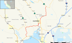
Map of western
California with SR 121 highlighted in red
1270:
920:
1.000 mi = 1.609 km; 1.000 km = 0.621 mi
831:
south (Soscol Avenue south) / Imola Avenue east –
1280:
954:
Indicates that the postmile represents the distance along
491:
from its southern terminus to its junction with SR 29 in
540:
California postmile § Official postmile definitions
1248:
1243:
1133:
California
Department of Transportation (August 2019).
1211:. Sacramento: California Department of Transportation.
1207:
California
Department of Transportation (April 2008).
1114:. Sacramento: California Office of Legislative Counsel
1041:. Sacramento: California Office of Legislative Counsel
807:
Interchange; north end of SR 29 overlap; SR 29 exit 16
806:
765:
North end of SR 12 overlap; south end of SR 29 overlap
764:
680:
1140:. Sacramento: California Department of Transportation
444:. When it leaves, it continues northward and meets
216:
198:
188:
178:
173:
150:
105:
86:
81:
73:
60:
32:
1271:Caltrans: State Route 121 highway conditions
1060:Federal Highway Administration (March 25, 2015).
1262:Template:Attached KML/California State Route 121
1088:. Washington, DC: Federal Highway Administration
629:west (Arnold Drive) / Bonneau Road –
436:. Upon leaving, it begins another overlap with
424:, where it then veers east. SR 121 then enters
8:
1188:"California Highways:Routes 121 through 128"
1281:California Highway Patrol Traffic Incidents
1063:National Highway System: California (North)
995:
993:
475:. SR 121 is eligible to be included in the
392:A sign on SR 37 directing drivers to SR 121
1291:California @ AARoads.com - State Route 121
545:
282:
1265:
1000:California Department of Transportation.
503:between SR 116 and the Napa County line.
1108:"Article 2.5 of Chapter 2 of Division 1"
950:
948:
465:California Freeway and Expressway System
1222:California Department of Transportation
989:
944:
532:were measured on the road as it was in
481:California Department of Transportation
1112:California Streets & Highways Code
1082:"What is the National Highway System?"
1035:"Article 2 of Chapter 2 of Division 1"
801:north / Imola Avenue west –
352:counties. Its southern terminus is at
29:
892:
889:
876:
873:
863:
860:
847:
844:
814:
811:
779:
774:
769:
712:
691:
688:
647:
612:
609:
583:
580:
528:Except where prefixed with a letter,
7:
1039:California Streets and Highways Code
440:, which happens to be a freeway, in
416:. As it continues northward through
77:33.567 mi (54.021 km)
1311:Roads in Sonoma County, California
1209:"Log of Bridges on State Highways"
360:, and its northern terminus is at
25:
538:for a full list of prefixes, see
1306:Roads in Napa County, California
972:
893:
822:
816:
792:
786:
738:
732:
725:
719:
658:
652:
620:
614:
584:
303:
288:
154:
132:
114:
90:
49:
35:
1276:Caltrans Traffic Conditions Map
864:Silverado Trail, Trancas Street
1286:California Highways: Route 121
473:Federal Highway Administration
1:
780:North end of freeway on SR 29
770:South end of freeway on SR 29
1316:State highways in California
368:. SR 121 passes through the
226:State highways in California
1226:All Traffic Volumes on CSHS
979:California Roads portal
537:
477:State Scenic Highway System
1337:
681:South end of SR 12 overlap
428:, where it begins a short
919:
914:
886:
882:
870:
866:
857:
853:
840:
707:
698:
694:
685:
642:
638:
606:
601:
575:
566:
561:
558:
554:
551:
548:
467:, but is not part of the
404:, and then runs past the
281:
221:
212:
169:
65:
48:
1002:"State Truck Route List"
926:
1086:National Highway System
667:west (Broadway) –
469:National Highway System
372:region of the southern
848:Soscol Avenue north –
516:
485:California Legislature
463:SR 121 is part of the
393:
340:. It runs through the
877:Wooden Valley Road –
514:
391:
27:Highway in California
1266:KML is from Wikidata
1175:on October 10, 2022.
1015:on September 5, 2015
396:The route begins at
958:rather than SR 121.
915:North end of SR 121
602:South end of SR 121
524:Major intersections
107:Major intersections
1186:Faigin, Daniel P.
517:
394:
941:
940:
705:
673:Boyes Hot Springs
573:
408:basin and across
384:Route description
319:
318:
315:
314:
61:Route information
16:(Redirected from
1328:
1321:Napa, California
1256:
1229:
1219:
1213:
1212:
1204:
1198:
1197:
1195:
1194:
1183:
1177:
1176:
1174:
1167:
1156:
1150:
1149:
1147:
1145:
1139:
1130:
1124:
1123:
1121:
1119:
1104:
1098:
1097:
1095:
1093:
1077:
1071:
1070:
1068:
1057:
1051:
1050:
1048:
1046:
1031:
1025:
1024:
1022:
1020:
1014:
997:
977:
976:
975:
959:
952:
934:
927:
897:
896:
827:
826:
825:
820:
819:
797:
796:
795:
790:
789:
743:
742:
741:
736:
735:
730:
729:
728:
723:
722:
703:
663:
662:
661:
656:
655:
625:
624:
623:
618:
617:
588:
587:
571:
546:
542:
489:Carneros Highway
487:named the route
414:Infineon Raceway
311:
307:
306:
296:
292:
291:
283:
158:
157:
136:
135:
118:
117:
108:
94:
93:
53:
39:
30:
21:
18:Carneros Highway
1336:
1335:
1331:
1330:
1329:
1327:
1326:
1325:
1296:
1295:
1267:
1264:
1259:
1258:
1257:
1241:
1237:
1232:
1220:
1216:
1206:
1205:
1201:
1192:
1190:
1185:
1184:
1180:
1172:
1165:
1158:
1157:
1153:
1143:
1141:
1137:
1132:
1131:
1127:
1117:
1115:
1106:
1105:
1101:
1091:
1089:
1079:
1078:
1074:
1066:
1059:
1058:
1054:
1044:
1042:
1033:
1032:
1028:
1018:
1016:
1008:
999:
998:
991:
987:
973:
971:
968:
963:
962:
953:
946:
937:
929:
925:
921:
894:
823:
821:
817:
815:
793:
791:
787:
785:
776:
753:American Canyon
739:
737:
733:
731:
726:
724:
720:
718:
714:
702:
659:
657:
653:
651:
621:
619:
615:
613:
585:
570:
556:
526:
509:
386:
362:State Route 128
322:State Route 121
304:
302:
289:
287:
155:
146:
133:
115:
106:
91:
82:Major junctions
56:
44:
43:
42:State Route 121
40:
28:
23:
22:
15:
12:
11:
5:
1334:
1332:
1324:
1323:
1318:
1313:
1308:
1298:
1297:
1294:
1293:
1288:
1283:
1278:
1273:
1240:
1239:
1238:
1236:
1235:External links
1233:
1231:
1230:
1214:
1199:
1178:
1151:
1125:
1099:
1072:
1052:
1026:
988:
986:
983:
982:
981:
967:
964:
961:
960:
943:
942:
939:
938:
936:
935:
922:
917:
916:
913:
907:Lake Berryessa
891:
888:
884:
883:
881:
875:
872:
868:
867:
865:
862:
859:
855:
854:
852:
846:
842:
841:
839:
813:
809:
808:
805:
782:
781:
778:
772:
771:
767:
766:
763:
716:
711:
706:
704:NAP 0.00-22.08
696:
695:
693:
690:
687:
683:
682:
679:
649:
646:
640:
639:
637:
611:
608:
604:
603:
600:
582:
579:
574:
572:SON 0.00-11.62
564:
563:
560:
557:
553:
550:
525:
522:
508:
505:
458:Lake Berryessa
385:
382:
366:Lake Berryessa
354:State Route 37
317:
316:
313:
312:
299:
297:
279:
278:
277:
276:
271:
266:
261:
259:Pre‑1964
256:
251:
246:
241:
236:
230:
229:
219:
218:
217:Highway system
214:
213:
210:
209:
200:
196:
195:
190:
186:
185:
180:
176:
175:
171:
170:
167:
166:
164:Lake Berryessa
152:
151:North end
148:
147:
145:
144:
130:
111:
109:
103:
102:
88:
87:South end
84:
83:
79:
78:
75:
71:
70:
66:Maintained by
63:
62:
58:
57:
54:
46:
45:
41:
34:
33:
26:
24:
14:
13:
10:
9:
6:
4:
3:
2:
1333:
1322:
1319:
1317:
1314:
1312:
1309:
1307:
1304:
1303:
1301:
1292:
1289:
1287:
1284:
1282:
1279:
1277:
1274:
1272:
1269:
1268:
1263:
1254:
1250:
1246:
1245:
1234:
1227:
1223:
1218:
1215:
1210:
1203:
1200:
1189:
1182:
1179:
1171:
1164:
1163:
1155:
1152:
1144:September 30,
1136:
1129:
1126:
1113:
1109:
1103:
1100:
1087:
1083:
1076:
1073:
1065:
1064:
1056:
1053:
1040:
1036:
1030:
1027:
1012:
1007:
1003:
996:
994:
990:
984:
980:
970:
969:
965:
957:
951:
949:
945:
932:
924:
923:
918:
912:
908:
904:
900:
885:
880:
869:
856:
851:
850:Downtown Napa
843:
838:
834:
830:
810:
804:
800:
783:
773:
768:
762:
758:
754:
750:
747:south /
746:
710:
701:
697:
684:
678:
674:
670:
666:
645:
641:
636:
632:
628:
605:
599:
595:
591:
578:
569:
565:
547:
544:
541:
535:
531:
523:
521:
513:
506:
504:
502:
501:Fremont Drive
498:
494:
490:
486:
482:
478:
474:
470:
466:
461:
459:
455:
451:
447:
443:
439:
435:
431:
427:
423:
419:
418:Sonoma County
415:
411:
407:
403:
399:
390:
383:
381:
379:
375:
374:Sonoma Valley
371:
367:
363:
359:
355:
351:
347:
343:
339:
335:
331:
330:state highway
327:
323:
310:
300:
298:
295:
285:
284:
280:
275:
272:
270:
267:
265:
264:Unconstructed
262:
260:
257:
255:
252:
250:
247:
245:
242:
240:
237:
235:
232:
231:
228:
227:
223:
222:
220:
215:
211:
208:
204:
201:
197:
194:
191:
187:
184:
183:United States
181:
177:
172:
168:
165:
161:
153:
149:
143:
139:
131:
129:
125:
121:
113:
112:
110:
104:
101:
97:
89:
85:
80:
76:
72:
69:
64:
59:
52:
47:
38:
31:
19:
1242:
1217:
1202:
1191:. Retrieved
1181:
1170:the original
1161:
1154:
1142:. Retrieved
1128:
1116:. Retrieved
1111:
1102:
1090:. Retrieved
1085:
1075:
1062:
1055:
1043:. Retrieved
1038:
1029:
1017:. Retrieved
1006:the original
928:
751:east –
559:Destinations
527:
518:
500:
499:, and along
497:Arnold Drive
496:
488:
462:
395:
342:Wine Country
325:
321:
320:
224:
1118:February 6,
1045:February 6,
931:Concurrency
899:SR 128
829:SR 221
644:Schellville
627:SR 116
577:Sears Point
442:Napa County
426:Schellville
420:, it meets
410:Tolay Creek
402:Sears Point
378:Napa Valley
358:Sears Point
309:SR 123
294:SR 120
160:SR 128
124:Schellville
100:Sears Point
1300:Categories
1193:2010-04-27
985:References
911:Rutherford
799:SR 29
749:SR 12
745:SR 29
677:Glen Ellen
665:SR 12
631:Glen Ellen
590:SR 37
406:Tolay Lake
344:region of
338:California
334:U.S. state
234:Interstate
193:California
138:SR 29
120:SR 12
96:SR 37
879:Fairfield
803:Calistoga
761:Fairfield
692:Napa Road
530:postmiles
1244:KML file
1019:June 30,
1011:XLS file
966:See also
933:terminus
901: –
635:Petaluma
592: –
555:Postmile
552:Location
370:Carneros
274:Freeways
199:Counties
174:Location
68:Caltrans
1092:July 1,
903:Winters
887:
871:
858:
837:Oakland
833:Vallejo
757:Vallejo
686:
607:
594:Vallejo
507:History
430:overlap
332:in the
328:) is a
269:Deleted
254:History
179:Country
1228:, 2007
1138:(XLSX)
775:R10.30
689:R10.79
669:Sonoma
598:Novato
568:Sonoma
549:County
483:. The
454:SR 128
446:SR 221
422:SR 116
346:Sonoma
326:SR 121
249:Scenic
203:Sonoma
74:Length
1173:(PDF)
1166:(PDF)
1067:(PDF)
956:SR 29
890:22.08
874:16.07
777:R4.47
715:R8.66
713:R4.47
562:Notes
456:near
438:SR 29
434:SR 12
432:with
412:near
398:SR 37
364:near
244:State
189:State
162:near
122:from
1253:help
1249:edit
1146:2017
1120:2019
1094:2012
1047:2019
1021:2015
861:9.40
845:6.55
812:6.01
709:Napa
700:Napa
648:7.44
610:6.69
581:0.00
534:1964
493:Napa
450:Napa
376:and
350:Napa
348:and
207:Napa
142:Napa
128:Napa
448:in
400:in
356:at
336:of
140:in
126:to
98:at
1302::
1251:•
1224:,
1110:.
1084:.
1037:.
992:^
947:^
909:,
905:,
835:,
759:,
755:,
675:,
671:,
633:,
596:,
460:.
380:.
301:→
286:←
239:US
205:,
1255:)
1247:(
1196:.
1148:.
1122:.
1096:.
1049:.
1023:.
1013:)
1009:(
324:(
20:)
Text is available under the Creative Commons Attribution-ShareAlike License. Additional terms may apply.