190:
651:
182:
50:
66:
352:
73:
100:
543:
189:
253:. The area of the park is 515.7 square kilometres (199.1 sq mi), of which 3,834 square kilometres (1,480 sq mi) is the area where any economic activity is prohibited. The park is located in the highest part of the Ukrainian Carpathians, on the eastern slopes in the
650:
272:
In 1921, in the highest part of the
Ukrainian Carpathians a nature reservation was created which originally had the area of 4.47 square kilometres (1.73 sq mi). In 1968, it was merged into the newly created
181:
312:(Dfc)). This climate is characterized by mild summers (only 1–3 months above 10 °C (50.0 °F)) and cold, snowy winters (coldest month below −3 °C (26.6 °F)).
615:
575:
348:
and contains a number of monuments of history and architecture, including historical wooden buildings. It is actively used for tourism, with 48 maintained trails (as of 2012).
282:
490:
431:
895:
336:, located within the park, is the highest single-drop waterfall in the Ukrainian Carpathians (84 metres (276 ft)). There are two lakes of glacial origin.
117:
65:
1126:
1116:
640:
281:, and included about a half of the area which previously belonged to the Carpathian State Reserve. The park is an independent unit subordinated to the
1087:
920:
584:
568:
547:
1111:
742:
1071:
1035:
970:
49:
1045:
835:
990:
980:
840:
820:
772:
269:(2,061 metres (6,762 ft)), is located at the borders of the park. The lowest point of the park is about 500 metres (1,600 ft).
945:
940:
880:
875:
731:
561:
278:
1121:
1040:
1015:
975:
830:
805:
659:
855:
630:
461:
210:
985:
850:
795:
486:
306:
1061:
1056:
950:
800:
762:
721:
229:. Carpathian National Nature Park is the first national park of Ukraine and one of the biggest national parks of the country.
1030:
845:
825:
777:
427:
35:
995:
1076:
1000:
870:
810:
592:
925:
900:
1066:
1025:
1020:
1010:
1005:
955:
935:
910:
610:
274:
915:
890:
885:
865:
860:
687:
681:
635:
605:
351:
960:
930:
766:
726:
295:
320:
The landscapes in the park include Alpine meadows and forests. The three most common tree species in the park are
1131:
1106:
787:
512:
965:
1051:
692:
672:
625:
752:
737:
712:
262:
717:
707:
697:
677:
246:
214:
93:
905:
277:. Carpathian National Nature Park was established in 1980 by the decree of the Council of Ministers of
757:
702:
667:
222:
747:
553:
392:
365:
250:
202:
309:
301:
242:
325:
454:
333:
254:
238:
1100:
39:
620:
600:
344:
The area of the
Carpathian National Nature Park was historically inhabited by
321:
132:
119:
299:
ecoregion. Because of its altitude, the climate of the
Carpathian Park is
542:
265:. The Prut has its source in the park, and the highest point of Ukraine,
226:
89:
345:
266:
221:. The park was established on 3 June 1980 to protect landscapes of the
218:
105:
516:
329:
453:
Kottek, M.; Grieser, J.; Beck, C.; Rudolf, B.; Rubel, F. (2006).
258:
557:
350:
455:"World Map of Koppen-Geiger Climate Classification Updated"
396:
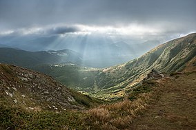
72:
283:
Ministry of
Ecology and Natural Resources of Ukraine
786:
658:
591:
164:
156:
148:
111:
85:
21:
515:. Carpathian National Nature Park. Archived from
395:. Carpathian National Nature Park. Archived from
585:National Conservation Areas of Nature in Ukraine
152:515.7 square kilometres (199.1 sq mi)
569:
8:
576:
562:
554:
487:"Dataset - Koppen climate classifications"
18:
428:"Карпатський національний природний парк"
1088:Categories of protected areas of Ukraine
513:"Territorial features of Carpathian NNP"
387:
385:
383:
381:
188:
180:
422:
420:
418:
416:
414:
377:
237:The area of the park is shared between
207:Карпатський національний природний парк
193:Dawn in Carpathian National Nature Park
28:Карпатський національний природний парк
225:. The headquarters of the park are in
302:Subarctic climate, without dry season
7:
434:from the original on 29 October 2016
84:
1127:Protected areas established in 1980
1117:Geography of Ivano-Frankivsk Oblast
430:(in Ukrainian). Україна Інкогніта.
279:Ukrainian Soviet Socialist Republic
493:from the original on April 7, 2022
14:
467:from the original on June 1, 2010
649:
541:
185:First snow on Chornohirsky Ridge
98:
71:
64:
48:
548:Carpathian National Nature Park
199:Carpathian National Nature Park
163:
22:Carpathian National Nature Park
1112:1980 establishments in Ukraine
393:"Official website of the park"
1:
460:. Gebrüder Borntraeger 2006.
307:Köppen climate classification
54:View from the Mount Hoverla
1148:
296:Carpathian montane forests
1122:National parks of Ukraine
1085:
896:Ivory Coast of Sviatoslav
647:
206:
59:
47:
33:
26:
275:Carpathian State Reserve
16:National park in Ukraine
356:
247:Ivano-Frankivsk Oblast
215:Ivano-Frankivsk Oblast
194:
186:
168:June 3, 1980
94:Ivano-Frankivsk Oblast
906:Karmeliukove Podillia
788:National nature parks
773:Yalta Mountain-Forest
743:Michael's Virgin Land
354:
289:Ecoregion and climate
263:Black Cheremosh River
249:, at the border with
192:
184:
133:48.38278°N 24.54389°E
732:Striltsivskyi Steppe
550:at Wikimedia Commons
245:in the southwest of
223:Carpathian Mountains
921:Kremenets Mountains
293:The park is in the
129: /
727:Stanytsia-Luhanska
593:Biosphere reserves
519:on 31 October 2020
357:
251:Zakarpattia Oblast
195:
187:
138:48.38278; 24.54389
1094:
1093:
1072:Zacharovanyi Krai
1036:Tsumanska Pushcha
996:Pushcha Radzivila
971:Northern Podillia
546:Media related to
310:Subarctic climate
179:
178:
1139:
1132:Verkhovyna Raion
1107:IUCN Category II
1046:Upper Pobuzhzhia
836:Desna-Stara Huta
763:Ukrainian Steppe
722:Provallia Steppe
653:
578:
571:
564:
555:
545:
529:
528:
526:
524:
509:
503:
502:
500:
498:
483:
477:
476:
474:
472:
466:
459:
450:
444:
443:
441:
439:
424:
409:
408:
406:
404:
389:
243:Verkhovyna Raion
208:
175:
173:
144:
143:
141:
140:
139:
134:
130:
127:
126:
125:
122:
104:
102:
101:
75:
74:
68:
52:
19:
1147:
1146:
1142:
1141:
1140:
1138:
1137:
1136:
1097:
1096:
1095:
1090:
1081:
991:Prypiat-Stokhid
981:Podilian Tovtry
841:Dniester Canyon
821:Charming Harbor
782:
778:Yelanets Steppe
660:Nature reserves
654:
645:
631:East Carpathian
587:
582:
538:
533:
532:
522:
520:
511:
510:
506:
496:
494:
485:
484:
480:
470:
468:
464:
457:
452:
451:
447:
437:
435:
426:
425:
412:
402:
400:
399:on 2 April 2015
391:
390:
379:
374:
362:
342:
318:
316:Flora and fauna
291:
255:drainage basins
235:
171:
169:
137:
135:
131:
128:
123:
120:
118:
116:
115:
99:
97:
81:
80:
79:
78:
77:
76:
55:
43:
17:
12:
11:
5:
1145:
1143:
1135:
1134:
1129:
1124:
1119:
1114:
1109:
1099:
1098:
1092:
1091:
1086:
1083:
1082:
1080:
1079:
1074:
1069:
1064:
1059:
1054:
1049:
1043:
1038:
1033:
1028:
1023:
1018:
1013:
1008:
1003:
998:
993:
988:
983:
978:
973:
968:
963:
958:
953:
948:
946:Lower Polissia
943:
941:Lower Dniester
938:
933:
928:
926:Kreminna Woods
923:
918:
913:
908:
903:
901:Kamianska Sich
898:
893:
888:
883:
881:Homilsha Woods
878:
876:Holy Mountains
873:
868:
863:
858:
853:
848:
843:
838:
833:
828:
823:
818:
813:
808:
803:
798:
792:
790:
784:
783:
781:
780:
775:
770:
760:
755:
750:
745:
740:
735:
729:
724:
715:
710:
705:
700:
695:
690:
685:
675:
670:
664:
662:
656:
655:
648:
646:
644:
643:
638:
633:
628:
623:
618:
613:
608:
603:
597:
595:
589:
588:
583:
581:
580:
573:
566:
558:
552:
551:
537:
536:External links
534:
531:
530:
504:
489:. World Bank.
478:
445:
410:
376:
375:
373:
370:
369:
368:
361:
358:
341:
338:
326:European beech
317:
314:
290:
287:
239:Nadvirna Raion
234:
231:
177:
176:
166:
162:
161:
158:
154:
153:
150:
146:
145:
113:
109:
108:
87:
83:
82:
70:
69:
63:
62:
61:
60:
57:
56:
53:
45:
44:
34:
31:
30:
24:
23:
15:
13:
10:
9:
6:
4:
3:
2:
1144:
1133:
1130:
1128:
1125:
1123:
1120:
1118:
1115:
1113:
1110:
1108:
1105:
1104:
1102:
1089:
1084:
1078:
1075:
1073:
1070:
1068:
1065:
1063:
1060:
1058:
1055:
1053:
1050:
1047:
1044:
1042:
1041:Tuzly Lagoons
1039:
1037:
1034:
1032:
1029:
1027:
1024:
1022:
1019:
1017:
1016:Skole Beskids
1014:
1012:
1009:
1007:
1006:Royal Beskids
1004:
1002:
999:
997:
994:
992:
989:
987:
984:
982:
979:
977:
976:Oleshky Sands
974:
972:
969:
967:
964:
962:
959:
957:
954:
952:
949:
947:
944:
942:
939:
937:
936:Lower Dnieper
934:
932:
929:
927:
924:
922:
919:
917:
914:
912:
911:Kholodnyi Yar
909:
907:
904:
902:
899:
897:
894:
892:
889:
887:
886:Hutsulshchyna
884:
882:
879:
877:
874:
872:
869:
867:
864:
862:
859:
857:
854:
852:
849:
847:
844:
842:
839:
837:
834:
832:
831:Derman-Ostroh
829:
827:
824:
822:
819:
817:
814:
812:
809:
807:
806:Boikivshchyna
804:
802:
799:
797:
794:
793:
791:
789:
785:
779:
776:
774:
771:
768:
764:
761:
759:
756:
754:
751:
749:
746:
744:
741:
739:
736:
733:
730:
728:
725:
723:
719:
716:
714:
711:
709:
706:
704:
701:
699:
696:
694:
691:
689:
686:
683:
679:
676:
674:
671:
669:
666:
665:
663:
661:
657:
652:
642:
641:West Polissia
639:
637:
634:
632:
629:
627:
624:
622:
619:
617:
614:
612:
609:
607:
604:
602:
599:
598:
596:
594:
590:
586:
579:
574:
572:
567:
565:
560:
559:
556:
549:
544:
540:
539:
535:
518:
514:
508:
505:
497:September 14,
492:
488:
482:
479:
471:September 14,
463:
456:
449:
446:
433:
429:
423:
421:
419:
417:
415:
411:
398:
394:
388:
386:
384:
382:
378:
371:
367:
364:
363:
359:
353:
349:
347:
339:
337:
335:
334:Huk Waterfall
331:
327:
323:
315:
313:
311:
308:
304:
303:
298:
297:
288:
286:
284:
280:
276:
270:
268:
267:Mount Hoverla
264:
260:
256:
252:
248:
244:
240:
232:
230:
228:
224:
220:
216:
212:
211:National Park
204:
200:
191:
183:
167:
160:National Park
159:
155:
151:
147:
142:
114:
110:
107:
95:
91:
88:
67:
58:
51:
46:
41:
40:national park
37:
36:IUCN category
32:
29:
25:
20:
856:Grand Meadow
815:
688:Dnieper-Oril
682:Swan Islands
668:Cape Martian
601:Askania-Nova
521:. Retrieved
517:the original
507:
495:. Retrieved
481:
469:. Retrieved
448:
436:. Retrieved
401:. Retrieved
397:the original
343:
319:
300:
294:
292:
271:
236:
198:
196:
27:
986:Pryazovskyi
851:Dzharylhach
796:Azov-Syvash
767:Chalk Flora
636:Roztochchia
213:located in
165:Established
157:Designation
136: /
112:Coordinates
1101:Categories
1062:Vyzhnytsia
1057:Verkhovyna
1048:(proposed)
951:Lower Sula
816:Carpathian
801:Bile Ozero
611:Carpathian
372:References
366:Biały Słoń
340:Public use
322:silver fir
259:Prut River
233:Topography
172:1980-06-03
124:24°32′38″E
121:48°22′58″N
1031:Syniohora
846:Dvorichna
826:Cheremosh
693:Drevlians
673:Cheremske
616:Chernobyl
606:Black Sea
355:park logo
203:Ukrainian
1077:Zalissia
1001:Pyriatyn
931:Kuialnyk
871:Holosiiv
811:Bug Gard
753:Polissia
738:Medobory
713:Kazantyp
523:28 April
491:Archived
462:Archived
438:28 April
432:Archived
403:28 April
360:See also
261:and the
227:Yaremche
90:Yaremche
86:Location
1067:Yavoriv
1026:Synevyr
1021:Sloboda
956:Meotyda
718:Luhansk
708:Karadag
698:Gorgany
346:hutsuls
257:of the
219:Ukraine
209:) is a
170: (
106:Ukraine
1011:Shatsk
916:Khotyn
891:Ichnia
866:Hetman
861:Halych
678:Crimea
621:Danube
332:. The
330:spruce
328:, and
103:
966:Nobel
961:Mezyn
758:Rivne
703:Kaniv
626:Desna
465:(PDF)
458:(PDF)
748:Opuk
525:2015
499:2019
473:2019
440:2015
405:2015
241:and
197:The
149:Area
38:II (
1052:Uzh
1103::
413:^
380:^
324:,
285:.
217:,
205::
96:,
92:,
769:)
765:(
734:)
720:(
684:)
680:(
577:e
570:t
563:v
527:.
501:.
475:.
442:.
407:.
305:(
201:(
174:)
42:)
Text is available under the Creative Commons Attribution-ShareAlike License. Additional terms may apply.