27:
55:
281:
39:
308:
62:
255:
because of the belief that those of
Japanese ethnicity had a distinct odor. This particular experiment was totally unsuccessful though dogs proved effective as an aid to sentries and advance scouts. This period of the island's history was featured on a June 2009 episode of the PBS series
265:
The western half and southern tip of the island became part of the Gulf
Islands National Seashore in 2002. The remainder of the island, including most of the beach, is still privately owned. The eastern beach is owned by
555:
636:
277:. In December 2016 Mississippi acquired the 492 acres that BP had purchased from the Brodie family in 2011. This section of East Beach was added to the Cat Island Coastal Preserve.
727:
548:
511:
428:
384:
629:
541:
224:
of the
Gulfport ship channel, however, Cat Island has lost its natural westward flow of sediment which provided material for the island to combat erosion.
564:
193:
133:
732:
722:
622:
200:(which were not introduced to Europe until the 20th century) for cats. It is unknown who discovered Cat Island. It is within the jurisdiction of
416:
220:
currents. Unlike the other
Mississippi islands, Cat Island's sand beaches are backed by dense forests of slash pines and live oaks. Due to the
54:
465:
98:
247:, the island was base for the Cat Island War Dog Reception and Training Center where Americans sent family dogs to be trained by the
686:
427:
Schindler, Sonny. (27 October 2015). "Outdoors Report:Flooded grass reds". Clarion Ledger. (Jackson). Retrieved 27 October 2015.
484:
737:
666:
598:
470:
189:
168:
645:
205:
201:
173:
519:
656:
271:
394:
370:
26:
676:
671:
593:
580:
360:
417:
https://www.hattiesburgamerican.com/story/news/2016/12/09/miss-acquires-492-acres-cat-island-bp-deal/95219380/
460:
603:
343:
515:
248:
492:
365:
313:
293:
258:
284:
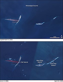
Cat Island (left) before (June 2004, bottom) and after (September 2005, top) Hurricane
Katrina.
280:
321:
289:
252:
444:
292:
shrank the island by eliminating the southern tip. During the foul weather associated with
347:
696:
585:
237:
217:
185:
533:
296:
a commercial fisherman reported abundant redfish in the flooded bayous of the island.
716:
496:
147:
691:
244:
614:
661:
161:
701:
389:
303:
156:
113:
100:
233:
38:
270:, who purchased it in April 2011 to use in assisting cleanup of the 2010
221:
197:
446:
Cat Island: The
History of a Mississippi Gulf Coast Barrier Island
229:
225:
204:. The western half and southern tip of the island is part of the
340:
618:
537:
216:
Cat Island is a unique "T-shaped" island created by colliding
196:. The island's name comes from French explorers who mistook
267:
43:
Historical map of the changing geomorphology of Cat Island
251:
for military service. The dogs were trained to sniff out
167:
155:
139:
129:
92:
84:
79:
385:"BP buys east beach of Cat Island - Long Beach"
512:"Hurricane Katrina Erodes the U.S. Gulf Coast"
630:
549:
8:
19:
637:
623:
615:
556:
542:
534:
37:
25:
18:
728:Landforms of Harrison County, Mississippi
485:"Initial Purchase of Land on Cat Island"
279:
333:
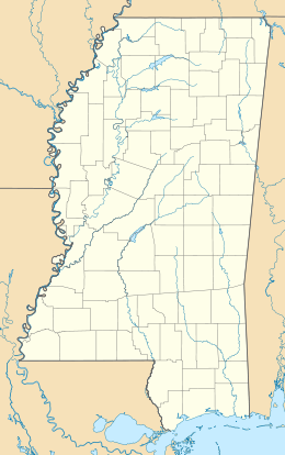
31:Dunes on the south side of Cat Island
7:
565:Mississippi–Alabama barrier islands
466:Geographic Names Information System
350:. US Army Quartermaster Foundation.
194:Mississippi–Alabama barrier islands
134:Mississippi–Alabama barrier islands
415:Hattiesburg American Dec. 9, 2016
61:
14:
687:Fort Massachusetts (Mississippi)
495:. March 28, 2002. Archived from
306:
60:
53:
471:United States Geological Survey
383:Nelson, Karen (April 7, 2011).
190:Gulf Coast of the United States
733:Gulf Islands National Seashore
723:Barrier islands of Mississippi
646:Gulf Islands National Seashore
489:Gulf Islands National Seashore
206:Gulf Islands National Seashore
1:
341:Quartermaster War Dog Program
202:Harrison County, Mississippi
16:US Gulf Coast barrier island
754:
371:Oregon Public Broadcasting
232:on Cat Island are home to
652:
571:
449:. McFarland. p. 205.
144:
48:
36:
24:
369:, Season 7, Episode 1.
738:Beaches of Mississippi
516:NASA Earth Observatory
429:Clarion Ledger website
285:
249:U.S. Army Signal Corps
493:National Park Service
283:
212:Formation and history
499:on February 14, 2005
443:Cuevas, John (211).
110: /
21:
366:History Detectives
346:2013-01-20 at the
314:Mississippi portal
294:Hurricane Patricia
286:
259:History Detectives
253:Japanese Americans
710:
709:
667:Petit Bois Island
657:Santa Rosa Island
612:
611:
599:Petit Bois Island
590:
322:Mississippi Sound
290:Hurricane Katrina
273:Deepwater Horizon
179:
178:
114:30.217°N 89.100°W
745:
639:
632:
625:
616:
588:
558:
551:
544:
535:
530:
528:
527:
518:. Archived from
507:
505:
504:
480:
478:
477:
450:
431:
425:
419:
413:
407:
406:
404:
402:
397:on 10 April 2011
393:. Archived from
380:
374:
359:Zuber, Tukufu. "
357:
351:
338:
316:
311:
310:
309:
125:
124:
122:
121:
120:
115:
111:
108:
107:
106:
103:
64:
63:
57:
41:
29:
22:
753:
752:
748:
747:
746:
744:
743:
742:
713:
712:
711:
706:
648:
643:
613:
608:
586:Isle of Caprice
567:
562:
525:
523:
510:
502:
500:
483:
475:
473:
459:
456:
442:
440:
438:Further reading
435:
434:
426:
422:
414:
410:
400:
398:
382:
381:
377:
358:
354:
348:Wayback Machine
339:
335:
330:
312:
307:
305:
302:
238:migratory birds
214:
174:Harrison County
151:
119:30.217; -89.100
118:
116:
112:
109:
104:
101:
99:
97:
96:
75:
74:
73:
72:
71:
70:
69:
65:
44:
32:
17:
12:
11:
5:
751:
749:
741:
740:
735:
730:
725:
715:
714:
708:
707:
705:
704:
699:
697:Fort Barrancas
694:
689:
684:
679:
674:
669:
664:
659:
653:
650:
649:
644:
642:
641:
634:
627:
619:
610:
609:
607:
606:
604:Dauphin Island
601:
596:
591:
583:
578:
572:
569:
568:
563:
561:
560:
553:
546:
538:
532:
531:
508:
481:
455:
454:External links
452:
439:
436:
433:
432:
420:
408:
375:
361:War Dog Letter
352:
332:
331:
329:
326:
325:
324:
318:
317:
301:
298:
236:and refuge to
218:Gulf of Mexico
213:
210:
186:barrier island
177:
176:
171:
165:
164:
159:
153:
152:
145:
142:
141:
140:Administration
137:
136:
131:
127:
126:
94:
90:
89:
88:Gulf of Mexico
86:
82:
81:
77:
76:
67:
66:
59:
58:
52:
51:
50:
49:
46:
45:
42:
34:
33:
30:
15:
13:
10:
9:
6:
4:
3:
2:
750:
739:
736:
734:
731:
729:
726:
724:
721:
720:
718:
703:
700:
698:
695:
693:
690:
688:
685:
683:
680:
678:
675:
673:
670:
668:
665:
663:
660:
658:
655:
654:
651:
647:
640:
635:
633:
628:
626:
621:
620:
617:
605:
602:
600:
597:
595:
592:
587:
584:
582:
579:
577:
574:
573:
570:
566:
559:
554:
552:
547:
545:
540:
539:
536:
522:on 2006-10-04
521:
517:
513:
509:
498:
494:
490:
486:
482:
472:
468:
467:
462:
458:
457:
453:
451:
448:
447:
437:
430:
424:
421:
418:
412:
409:
396:
392:
391:
386:
379:
376:
372:
368:
367:
362:
356:
353:
349:
345:
342:
337:
334:
327:
323:
320:
319:
315:
304:
299:
297:
295:
291:
282:
278:
276:
274:
269:
263:
261:
260:
254:
250:
246:
241:
239:
235:
231:
227:
223:
219:
211:
209:
207:
203:
199:
195:
192:, one of the
191:
187:
183:
175:
172:
170:
166:
163:
160:
158:
154:
150:
149:
148:United States
143:
138:
135:
132:
128:
123:
95:
91:
87:
83:
78:
56:
47:
40:
35:
28:
23:
692:Fort Pickens
681:
575:
524:. Retrieved
520:the original
501:. Retrieved
497:the original
488:
474:. Retrieved
464:
461:"Cat Island"
445:
441:
423:
411:
399:. Retrieved
395:the original
388:
378:
364:
355:
336:
287:
272:
264:
257:
245:World War II
242:
215:
181:
180:
146:
677:Ship Island
672:Horn Island
662:Perdido Key
594:Horn Island
589:(submerged)
581:Ship Island
162:Mississippi
130:Archipelago
117: /
93:Coordinates
717:Categories
702:Fort McRee
682:Cat Island
576:Cat Island
526:2006-05-04
503:2006-05-04
476:2006-04-13
390:Sun Herald
328:References
234:alligators
182:Cat Island
68:Cat Island
20:Cat Island
275:oil spill
80:Geography
401:29 April
344:Archived
300:See also
288:In 2005
222:dredging
198:raccoons
188:off the
85:Location
243:During
230:marshes
105:89°06′W
102:30°13′N
226:Bayous
169:County
184:is a
157:State
403:2011
228:and
363:".
719::
514:.
491:.
487:.
469:.
463:.
387:.
268:BP
262:.
240:.
208:.
638:e
631:t
624:v
557:e
550:t
543:v
529:.
506:.
479:.
405:.
373:.
Text is available under the Creative Commons Attribution-ShareAlike License. Additional terms may apply.